Planina pod Golico - Koča na Golici
Starting point: Planina pod Golico (980 m)
| Latitude/Longitude: | 46,47060°N 14,05990°E |
| |
Walking time: 1 h 30 min
Difficulty: easy marked way
Elevation gain: 602 m
Elevation difference along the route: 602 m
Map: Karavanke - osrednji del 1:50.000
Recommended equipment (summer):
Recommended equipment (winter): ice axe, crampons
Views: 62.177
 | 4 people like this post |
Access to starting point:
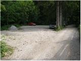
From the highway Ljubljana - Jesenice we take the exit Lipce (also possible Hrušica) and follow the road ahead in the direction of Jesenice, where signs for Planina pod Golico direct us onto an ascending road (the turn-off is marked and is located at the health center in Jesenice). The relatively steep road soon brings us to the mentioned village, where in May we can admire the blooming of daffodils on the surrounding meadows. From Planina pod Golico we drive ahead to the next crossroad, where we notice numerous signposts. Here we continue right and drive another good 50 meters to the parking lot below the Savske jame.
Route description:
At the beginning of the parking lot we notice the signposts, which direct us left along an asphalt road upwards. After a short ascent the path brings us to agrotourism Betel and behind it to a crossroad, where we continue right in the direction of Golica. After a few more minutes of walking along the road we arrive at the hut Pri Fencu. Here be attentive, as just a few steps ahead a wide marked path branches off to the right, leading to Golica.
The path ahead ascends across a short meadow, behind which we reach pleasant shade through which the path continues. After approximately half an hour of walking we step onto a macadam road, which we follow to the right, but only to the lower station of the cargo cableway.
From the cableway we continue towards the Koča na Golici along a path that ascends quite steeply through increasingly sparse forest. After a good hour of walking the path brings us out of the forest onto unvegetated slopes from which we already see the hut ahead. A little further we reach a junction, where we continue left (right to Struška, Markljev and Pusti Rovt). We follow this path, quite steep in the final section, to the hut.

Photos:
 1
1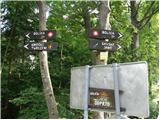 2
2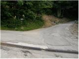 3
3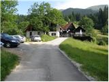 4
4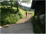 5
5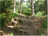 6
6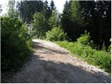 7
7 8
8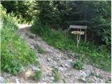 9
9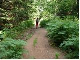 10
10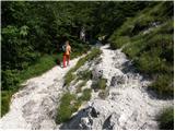 11
11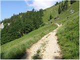 12
12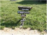 13
13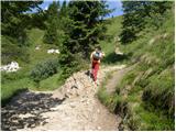 14
14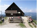 15
15
Discussion about the trip Planina pod Golico - Koča na Golici
|
| kolesar14. 03. 2007 |
We plan to visit the hut on Sunday. Does anyone know if it's open at all (for the weekend of course)
|
|
|
|
| Gost14. 03. 2007 |
On the PD Jesenice website it says it's closed.
|
|
|
|
| Gost16. 03. 2007 |
the hut is closed at this time, it opens around May
|
|
|
|
| Gost17. 03. 2007 |
Still I recommend a nice tour, snack in the backpack and path under the feet. It's worth it.
|
|
|
|
| heinz28. 10. 2009 |
alex, aren't you that person yourself??
|
|
|
|
| Fazo29. 10. 2009 |
Really, this hut keeper at the Koča na Golici is ... speechless, just don't know why someone takes on something they're not into and is always in a bad mood. Everything is a burden to him. As if you owe him something. ... speechless, just don't know why someone takes on something they're not into and is always in a bad mood. Everything is a burden to him. As if you owe him something.
|
|
|
|
| dore29. 10. 2009 |
What's wrong with you? Do you want a five-star hotel on Golica with pool, hot water, Viennese schnitzels...
Like a real guest, pack lunch in the backpack and hit the trail.
|
|
|
|
| turbo29. 10. 2009 |
Dore, no no!
Just two stars, cold shower and pancakes!  And no trail under feet, rather some two or four stinky cyclists And no trail under feet, rather some two or four stinky cyclists 
We understand each other, don't we?!?
|
|
|
|
| Fazo30. 10. 2009 |
No, just the greeting when ordering at the counter doesn't have to be "what do you want?" and when I reply "Hello, I'd like a tea." he snaps "just that or what?" throws the tea on the counter (I won't talk about it spilling) and issues the bill. I pay, leave and of course say goodbye. He doesn't.
Anyway, everyone has their own conscience. I know that I never pass a person in the mountains without greeting them. I don't "demand" much, a fair treatment is enough for me. And from a person who decides to run a hut, I rightfully expect that.
And Dore, as you see, I don't expect a pool and Viennese schnitzels anywhere.
|
|
|
|
| Mojcej30. 10. 2009 |
The benches around the hut were probably originally not intended as a storage area for crates of empty bottles of various drinks. Or were they? Hikers should stand or sit on the grass... My experiences with the staff friendliness vary depending on the person. Pleasant and 'less pleasant'.
|
|
|
|
| klavdy66. 04. 2011 |
Is the hut possibly already open on weekends? Thanks for the answer
|
|
|
|
| oakley_sf6. 04. 2011 |
No, the hut is open from May 1st
|
|
|
|
| bostjan856. 04. 2011 |
what about one day before May 1st?
|
|
|
|
| heinz6. 04. 2011 |
I wouldn't know for this year, but usually on 30.4. they light a bonfire.
|
|
|
|
| marezt22. 02. 2016 |
Is the path to the hut well-trodden? Are crampons and gaiters needed?
|
|
|
|
| Kranj26. 02. 2016 |
marezt this is the same as asking if you can go in shorts and t-shirt!!!!! I don't know why you go hiking if in mid-winter you ask about crampons and gaiters!! No one needs an ice axe anyway!!! Waste of words!!
|
|
|
|
| jprim26. 02. 2016 |
@ Kranj
So much arrogance for one perfectly simple question.
LP!
|
|
|
|
| Kranj27. 02. 2016 |
Early in July I'm going to the sea, is it smart to take swimsuits with me
|
|
|
|
| jprim27. 02. 2016 |
@Kranj
If you're macho, you can leave them at home.
|
|
|
|
| Pelca1. 09. 2016 |
Yesterday I was at Golica. I agree with some comments - service could really be better. We're not demanding a five-star hotel, but I think a hut keeper can't be just anyone, just like a regular innkeeper can't be just anyone. If you deal with people, you have to be someone who has feeling for people. I had the feeling that I was bothering and disturbing the peace because I came to order. Everything so without energy or completely without good mood. The food isn't anything special either.
|
|
|
|
| Ljubljana1. 09. 2016 |
Have they opened the toilets in the hut? Or do they still send people to the field WC? As for the comment "Pelce" - pure truth.
|
|
|
|
| Pelca2. 09. 2016 |
The toilets have been opened, yes.
|
|
|
|
| AlesV6228. 05. 2025 20:03:35 |
Has anyone been to Golica this weekend? How are the narcissi and how far is car access possible? Until what time in the morning do you need to be at the location to still get free parking spaces. We would go on Saturday. Thanks Aleš
|
|
|
|
| franca29. 05. 2025 09:35:42 |
Since yesterday: narcissi are there and will be for some time. We went on foot from Planina pod Golico down to Pristava. Quite a few cars were parked at the Suha saddle.
|
|
|
|
| Martin Dercar17. 11. 2025 21:11:30 |
Nice here, been 2x already, but folks really no offense I have nothing against animals just dogs don't belong on the table dogs walking on the table and I didn't make it up I have a picture think that someone will eat from that table really dogs on benches and then on tables no go think about children and everyone who doesn't know that your dog had its butt on the table licked the table yuck in plain terms
|
|
|
|
| sla18. 11. 2025 08:11:50 |
Can you express yourself in Slovenian? This is completely unreadable.
|
|
|
|
| Martin Dercar21. 11. 2025 09:00:23 |
Learn it yourself, brother, have a nice weekend and safe steps
|
|
|
|
| saram21. 11. 2025 19:46:22 |
Next time when I come to the hut with a baby and it's soiled I'll change it on the table and see your comments you who have pets on tables in huts. If it's a house pet keep it at home.
|
|
|
|
| 1muha22. 11. 2025 20:47:21 |
And left the diaper on the table or under the table. Wasn't just once I came across such a diaper stash. Greetings.
|
|
|
|
| ppegan23. 11. 2025 20:39:52 |
Brane, no people aren't like that it doesn't occur to us to do or leave such things in the mountains. Only and exclusively dogs are the problem of the modern world their owners are pure evil whose only meaning in life is to walk dogs on tables because there's no space elsewhere. That mice martens weasels foxes and numerous birds walk/urinate/defecate on these same tables is not noteworthy. Ah yes how some up here are hostile towards dogs which also save lives give people support are helpers in hospitals nursing homes and various illnesses that's completely negligible. I just hope these rare individuals never need dog help in the mountains or anywhere else.
|
|
|
To post a comment you must log in:
If you do not yet have a username, you must first
register.