Planina Podvežak - Kocbekov dom na Korošici
Starting point: Planina Podvežak (1500 m)
| Latitude/Longitude: | 46,33190°N 14,67260°E |
| |
Walking time: 2 h 15 min
Difficulty: easy marked way
Elevation gain: 308 m
Elevation difference along the route: 460 m
Map: Kamniške in Savinjske Alpe 1:50.000
Recommended equipment (summer):
Recommended equipment (winter):
Views: 142.554
 | 12 people like this post |
Access to starting point:
First, we drive to Luče, then continue driving into the Podvolovjek valley (direction Kamnik and Kranjski Rak). At the road marker between 11 and 11.5 km, we will arrive at a smaller intersection, where the road towards the farm Planinšek and mountain pastures Podvežak, Ravne and Vodole branches off to the right (the turn-off is marked). We head onto this initially still asphalted road, which we follow at the intersections in the direction of the mountain pasture Podvežak. After a relatively long and in the upper part also poorer macadam road, we will reach the parking lot below the mountain pasture Podvežak (at the starting point there is a barrier and numerous mountain signposts).
From Kamnik we drive towards the mountain pass Črnivec, but only to the intersection where the road towards Kranjski Rak branches off sharply to the left (the turn-off is marked and is located only 500 m before the mentioned pass). At the intersection at Kranjski Rak we continue straight on the main road, which starts descending into the Podvolovjek valley. In the mentioned valley, only 100 m past the Gams bar, we will come to an intersection, where the road towards the farm Planinšek and mountain pastures Podvežak, Ravne and Vodole branches off to the left (the turn-off is marked). Further, follow the above description.
Route description:
From the parking lot, we head onto the footpath (or road) in the direction of the mountain pasture Podvežak. Both the road and the footpath, which during the ascent crosses the forest road, bring us in 15 minutes of moderate ascent to the shepherd's hut on the mountain pasture Podvežak, from which a beautiful view opens towards Rogatec and Lepenatka.
From the mountain pasture, we continue on the marked but initially poorly visible path, which soon enters the forest. The path through the forest ascends somewhat more steeply, then transitions into a smaller unvegetated valley, above which it completely flattens. This is followed by a few minutes of crossing the slopes below the side ridge of Deska, then the path brings us to a less noticeable junction, where an unmarked path branches off to the left towards Deska and Vodotočno jezero. We continue straight on the marked path, which descends into a pleasant grassy plain, then turns somewhat to the right and ascends through a belt of dwarf pines. At the top of the ascent, the path from the mountain pasture Vodole joins from the right; we continue left, cross the grazing fence, and after a few more steps we reach Inkretov studenec, which is located just a few meters from the path.
This is followed only by a slight ascent, then the path flattens again and brings us below the relatively steep and in snow avalanche-prone slopes of Tolsti vrh. A little further, the pleasant path brings us to a marked junction, where we continue slightly left in the direction of Korošica (slightly right: chapel on Molička peč (mountain pasture)). The path ahead crosses the slopes below Tolsti vrh for some time longer, then transitions onto the plateau-like terrain of Dleskovška planota, which is riddled with numerous abysses and pits. The path, continuing with some shorter ascents and descents, then quickly brings us to a junction, where the path from Robanov kot and mountain pasture Ravne joins from the right side.
We continue in the direction of Korošica on the path which ascends across to the saddle between the less known Koroški vrh on the left and Mala Ojstrica on the right. We continue straight downhill (left Prag, right Ojstrica via Mala Ojstrica) on the marked path, which starts descending towards Korošica. After a few minutes of descent, we step onto the expansive grassy slopes of Korošica, along which we then walk in a few minutes to the mountain hut.

Along the route: Sedelce (1900m)
Photos:
 1
1 2
2 3
3 4
4 5
5 6
6 7
7 8
8 9
9 10
10 11
11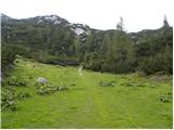 12
12 13
13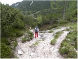 14
14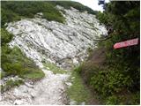 15
15 16
16 17
17 18
18 19
19 20
20 21
21 22
22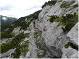 23
23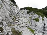 24
24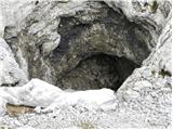 25
25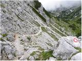 26
26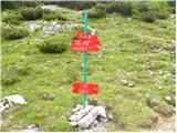 27
27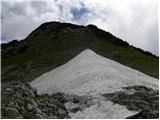 28
28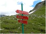 29
29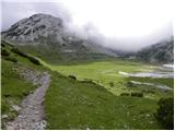 30
30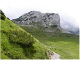 31
31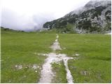 32
32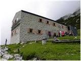 33
33
Discussion about the trip Planina Podvežak - Kocbekov dom na Korošici
Show older messages
|
| Gost27. 10. 2006 |
The trip was long and quite strenuous but pleasant.
|
|
|
|
| Gost24. 06. 2007 |
Brane V. Was here 23.06.2007 from Kamniška Bistrica. Uncleared path-branches. Hut is being renovated.
|
|
|
|
| Gost2. 07. 2007 |
I was at Kocbekov dom, but I have to tell you that everything is complete chaos. WC so neglected, dirty; I can't find a single nice word for Kocbekov dom. A few years ago it was all different.
|
|
|
|
| Gost2. 07. 2007 |
I agree with the visitor's opinion. I also have not a single nice word, everything dirty, neglected. I saw that the hut is being renovated, but still they could at least clean the outdoor toilets a bit. Horribly dirty and neglected. We were horrified even to eat there!
|
|
|
|
| Gost2. 07. 2007 |
The trail from Planina Podvežak is personally one of the most beautiful to me in the Kamnik Alps - very picturesque and relaxing. Last year there were two extremely friendly caretakers in the hut. I think it will be the most beautiful again once they renovate the cottage.
|
|
|
|
| Gost3. 07. 2007 |
We were also there recently in Korošica. Everything is really wrong and neglected. The society that owns the hut? should help a bit with a work action and clean both the house and the surroundings. Otherwise, the hut will lose its good reputation and all the effort and work will be in vain. What a pity! Because last year it was really nice in the hut, really a bit neglected and old, but really nice, especially towards the end of the season, the weather was nice and the two older caretakers were really fine.
|
|
|
|
| Gost8. 07. 2007 |
For those going for the first time: access to the starting point via Kranjski Rak requires 8km descent on macadam and from the mentioned "bar at Gams" another 10km macadam ascent. A bit shocking if you don't know beforehand, otherwise with persistence even an ordinary car makes it to the top. The trail to Korošica is super, a bit up and down throughout.
|
|
|
|
| Gost8. 07. 2007 |
Greetings!
3 years ago I was at Korošica and was pleasantly surprised. About 10 minutes from the hut at Korošica, two marmots were curiously looking around. I haven't seen such beautiful animals in nature until now. When I arrived at the mentioned hut, they were already playing around the tables.
Can they still be seen?
|
|
|
|
| Gost8. 07. 2007 |
You were lucky, because the marmot is shy and hides quickly. To play around the tables, that means domesticated. But you can see them at Trupeje, above bivouac Nogara, in Suhor rušje... but you have to be lucky. I once saw 12 of them piled up on one rock basking in the sun. Family with young ones.
|
|
|
|
| Gost9. 07. 2007 |
The description of the "road" from Gams onwards deterred me from trying to drive there, but I'm interested if perhaps someone knows how the "road" to that other pasture is, I think it's called Ravne? Is there more hope to reach the goal by car if I have a small, not very powerful car, I'm a long-time driver otherwise, but I don't tackle extremely bad roads.
Maybe it wouldn't be bad at all if in the trail descriptions - access to starting point - where the road is so-so, it was regularly written, so that a few of us "rabbits" wouldn't turn around when we got there?
|
|
|
|
| Gost9. 07. 2007 |
Roads to Planina Podvežak and Ravne are approximately equally "quality" - that's my experience from last year, but maybe worse this year due to rain? Last year I slowly reached both planinas with Citroen C3 (in 1st and 2nd gear).
|
|
|
|
| Tadej9. 07. 2007 |
Accesses to starting points are described up to where any personal car can reach, but indeed sometimes slower and more careful driving is needed. In winter many roads are impassable due to snow, in summer a thunderstorm can make even the nicest road impassable. Sometimes many hikers get stuck on the upper side of the road. To Podvežak and Ravne the roads are relatively nice, only thicker stones on the road and occasionally deeper ruts bother. PP: road over Kranjski rak being prepared for asphalt.
|
|
|
|
| Gost15. 07. 2007 |
The road to Planina Podvežak is this year, compared to previous years, nicely drivable, given the road status. Kocbekov dom has obviously been successfully renovated in a few days, cleaned the surroundings and WC. Already at first glance you can see that windows and doors have been replaced. Building materials and old equipment are stacked under the hut and nothing disturbs hikers outside at the tables. The interior of the hut is also exemplary arranged.
|
|
|
|
| Gost2. 08. 2007 |
With children we plan a circular path Planina Podvežak, Kocbekov dom, Molička peč, Planina Podvežak. Do you have any experience? Is it feasible in one day? How are the signposts and markings? Thanks.
|
|
|
|
| Gost2. 08. 2007 |
The path is easy and not strenuous. Time-wise it can also be done in one day. Podvežak, Korošica, Ravne around 5h and another good hour to the car by road. Good luck!
|
|
|
|
| Gost3. 08. 2007 |
You can also go back to Podvežak, i.e. not to planina Ravne, although the path Ravne-Korošica is much nicer to me than the one from Podvežak to Korošica. So: Podvežak-Korošica-chapel below Molička peč-Podvežak. As far as I remember the markings were worse from Molička back to Podvežak - who saves on tongue, starves for bread...
|
|
|
|
| mare123. 08. 2007 |
Regarding the path from Kamniška Bistrica. The path is quite nice and maintained all the way to Presedljaj. Then there are really a few pine branches that can scratch you. You also have to watch out for cows that don't like to move out of the path. The hut is nice and maintained (renovated). I think the opening is 01.09.07 (visited 19.08.07)
|
|
|
|
| Gost23. 08. 2007 |
Even a renovated hut won't help if the cooks don't know how (read: skimp on coffee) to brew something even remotely resembling coffee...
|
|
|
|
| oliva21. 04. 2008 |
Is the winter room in Kocbekov dom open?
|
|
|
|
| Tadej21. 04. 2008 |
In winter, an equipped winter room with gas stove, gas lamp, bed and kerosene stove (for 5 people) is available to winter hikers and ski tourers. The winter room key is reserved at PD Celje-Matica and picked up from farmer Mlinar, Podveža 44, Luče - Planinšek na Planici - (03 584 42 54), where users must leave ID and sign a statement with safety instructions for proper and safe use of heating and lighting appliances. Payment 25 € per day (from pickup to return of keys) for 1 to 5 visitors (for each person over 5, additional 4 € per day). Members of PD Celje-Matica get 50% discount. We also ask that at the end of use, check the condition of the winter room and report any deficiencies to farmer Mlinar or PD Celje-Matica. We wish you a pleasant stay in the winter room.
Source: http://www.planinsko-drustvo-celje.si/korosica.htm
|
|
|
|
| počasni27. 08. 2008 |
I was at Korošica last year at the end of August and they were renovating the hut. It didn't seem anything so terrible that I could criticize. Service was friendly and fine, beer cold... that's enough for me.
Now the hut is probably already renovated. Can someone describe how it is now?
|
|
|
|
| vojko17. 10. 2008 |
The hut is closed for this year, the path is quite demanding on ice. If anyone plans to extend the tour to Ojstrica, count 6 hours.
|
|
|
|
| NEIC00822. 05. 2009 |
What are the current conditions?? Snow??
|
|
|
|
| reina14. 06. 2009 |
I was there yesterday, bad weather, the higher I went towards the summit, the more the fog swirled around. Quite cold. Still quite a few snow patches in some places that need to be crossed. A bit slippery, especially in the afternoon when the sun might shine.
From Korošica I continued to Molička planina, also quite a lot of snow there. The hut on Molička is still closed.
|
|
|
|
| GričarA23. 11. 2009 |
Is there any path from below Podvolovljek (not climbing)?
|
|
|
|
| lepenatka24. 11. 2009 |
From Lučka Bela... there is an easier path.
In "Vseznamu gora - Kamniško-Savinjske Alpe" you have this path described (beyond Lončem - Kocbekov dom na Korošici).
Enjoy!
|
|
|
|
| MatevžRebernak12. 01. 2010 |
Nice greetings to all!
I have one question, namely how is this tour in winter or is any additional equipment needed besides good footwear and fitness?
|
|
|
|
| pikec112. 01. 2010 |
Hi
What falls under mandatory winter equipment???
Is it needed or must you have it with you!
Best regards
|
|
|
|
| geppo12. 01. 2010 |
I haven't walked here after such heavy snow yet (up to 15cm). I don't know the current condition either? The trail is marked with winter markers (iron poles). I advise you to stick to that trail, because in this part of the trail there are quite a few sinkholes that are now covered with snow....!!
It's better to tackle the winter trail if you know the summer one. Otherwise, there are no severe ascents and descents. I advise you: wait for a track that someone will have broken before you. There are quite a few visitors here.
Best regards
and calculate that the road is plowed only to the Planinšek farm - from there to Planina Podvežak (starting point) it's quite far!!
|
|
|
|
| MatevžRebernak12. 01. 2010 |
Thanks for the information geppo and pikec. I was last August on Ojstrica via this trail so I already know it. So pikec1, without crampons, snowshoes, ice axe this tour is not feasible?
|
|
|
|
| geppo12. 01. 2010 |
Even though you asked the question to "pikec1" I will try to answer you again.
You asked about this tour in winter!!
In winter it depends on the conditions that will be there when you tackle this route. I walked it in winter (December) and didn't need anything. In current conditions I would take snowshoes, for this trail I think crampons would not be needed nor ice axe. Usually you carry these things if you tackle winter trails. Maybe soon someone on the forum will describe the trail and conditions and you'll know exactly what awaits you!
Best regards
|
|
|
|
| MatevžRebernak12. 01. 2010 |
Geppo, many thanks for the detailed information.
lp
|
|
|
|
| Wine14. 01. 2010 |
Hi!
How much walking time from Planinšek farm to Podvežak? Possible to reach Planinšek by car without chains?
|
|
|
|
| geppo14. 01. 2010 |
I don't know current road conditions (chains or not). I'd say: mountain roads usually better plowed than in valley and if you drive first two km, then you'll make it to Planinšek. Or call Planinšek's phone and ask for info. From Planinšek it's surely one hour good walking.
Lp
|
|
|
|
| Kriška12. 07. 2010 |
I'm interested in the current condition of the forest road to the parking lot at Planina Podvežak?
|
|
|
|
| jprim12. 07. 2010 |
The road is in quite good condition, maybe watch out for some potholes, otherwise no issues.
Best regards!
|
|
|
|
| Fazo13. 07. 2010 |
btw. we were up there last week and it's quite solid for a gravel road.
|
|
|
|
| bostjan8514. 07. 2010 |
well-maintained path, a bit long
as for the hut, I wasn't disappointed at all, friendly service, only the beer is a bit expensive, but what can you do 
|
|
|
|
| jprim14. 07. 2010 |
Perfectly understandable that it's long, around 14 km, and since you drive very high, you look at Rogača almost at the same height.
But you can start lower, Za Loncem, Robanov kot, those are starting points that I say are the real path to Ojstrica, since from Podvežak to Korošica is already a short walk for some.
LP!
|
|
|
|
| bostjan8515. 07. 2010 |
I'm not saying it was strenuous, just for us Prekmurje folks who only know walking on flat land even this is something, especially since you have to drag a child along 
|
|
|
|
| stanko115. 07. 2010 |
I think every ascent is praiseworthy. Some are capable of more, others less, but all are trying.
|
|
|
|
| DADA8. 07. 2011 |
How long do you drive on that torn-up road? Judging by the pictures there's not much shade, is it doable to hike in that heat?
|
|
|
|
| geppo8. 07. 2011 |
The road isn't even that torn up...
Sometimes after heavy rain there are some ditches and stones, otherwise it's OK for those conditions.
If it's 14 km then calculate the approximate driving time yourself.
|
|
|
|
| LukaSLO8. 07. 2011 |
The road is OK at least in my view, exceptions are some heavy downpours, but you get there quite normally with a regular car.
|
|
|
|
| izi_30. 07. 2011 |
The road is really poor, but the whole excursion is really great. In the hut they are especially friendly, the whole team is super.
|
|
|
|
| helsinki18. 08. 2012 |
Very nice excursion, beautiful nature, easy path.
|
|
|
|
| matbal10. 09. 2012 |
Access is fine (quite long drive on gravel) - for slightly lower cars like mine, very slow driving is needed
The girl is a complete beginner in hiking and has a bit of fear of hills, so this path was more than excellent. After the initial hour where you have to tackle a relatively steep slope, the continuation is a pleasant walk.
The destination itself, Korošica, is worth seeing anyway. No complaints about the hut and service.
I recommend this tour to families and beginners
|
|
|
|
| slavko26. 10. 2012 |
Really interesting tour, only 300 meters of ascent, in reality due to descents a full 600 up and 300 down. We were on Sunday the last day of operation of the hut, in fairy-tale weather. The hostess friendly, served refreshments of all kinds and....charged nothing. "Next year when you come again", she said. And we will.
The road? It goes, but it's really a bit long...
|
|
|
|
| mic21. 06. 2013 |
If anyone has driven this road recently, please write to me what condition it's in now. I have a smaller car. LP
|
|
|
|
| culetto321. 06. 2013 |
Drove up on Saturday and the road to Planina Podvežak is in super condition for macadam. Quick into the car and a jump to the grassy slopes of Korošica
|
|
|
|
| mic22. 06. 2013 |
culetto3
Thank you very much for the reply. Best regards
|
|
|
|
| Francek6528. 07. 2013 |
on Sunday, July 4th we're going up, if the weather permits.
|
|
|
|
| Lisica31. 07. 2013 |
Yesterday walked this path. Easy walking trail with nice flowers along the path. Since I didn't want to go back I walked a bit more around the alpine pasture and met a marmot.
On the whole trail (6h hiking) I only saw one hiker from afar. No crowds in the hut either.
Path to starting point is approx 10 km from main road of which 8.5km gravel but road is in good condition.
|
|
|
|
| luigi2. 08. 2013 |
First let me say I'm not some spoiled person or similar but regarding the hut at Korošica and its food I can say I've never eaten anything so bad, tasteless and more nowhere in the mountains.
And I've walked a good part of our mountains.
|
|
|
|
| Francek655. 08. 2013 |
LOST!!! On Sunday, 4.8.2013, a group of hikers went from the parking area at Podvežak, past the shepherd's hut - Inkretov studenec - towards Korošica. We returned past Molička peč, again past the spring to the parking lot. A friend lost his car keys, VW golf, on this route. If anyone finds them, please call: 041-763-648. Thanks in advance.
|
|
|
|
| balon11. 08. 2013 |
how passable is the road to the starting point of the ascent?
Thanks,
Balonček
|
|
|
|
| sergejom11. 08. 2013 |
At the parking lot below Podvežak you see all sorts of cars from Clios to Land Rovers, everything gets up there, the road is mostly good, solid everywhere.
|
|
|
|
| balon11. 08. 2013 |
thanks for the answer
|
|
|
|
| balon15. 08. 2013 |
given the rainfall, I'm wondering how passable the road is?
Thanks and best regards,
Balon
|
|
|
|
| kranjskalilija111. 09. 2013 |
On Friday, August 30th, my colleagues and I made a mini union trip and conquered Korošica. We drove with a van to the parking lot in Podvežak, the road was nicely passable. The trail was beautiful, up and down a bit, with wonderful views, we recommend it to everyone, we also detoured to the chapel on Molička planina. At the hut the kitchen welcomed us nicely. Due to the comments here we were a bit worried about the food, but the jota and ričet were excellent. We met quite a few interesting hikers, including a sympathetic 86-year-old gentleman who is a regular visitor to Korošica. We had a really good time, Ojstrica tempted us too. For next time!
|
|
|
|
| balon19. 05. 2014 |
I'm wondering if the path is suitable for a 5-year-old.
Nice regards,
Baloncki
|
|
|
|
| nacka.19. 05. 2014 |
My opinion is that the path is too long for a five-year-old. Primož A., what do you think?
Nacka
|
|
|
|
| otiv19. 05. 2014 |
It holds that it's a good two hours of walking too much for a child. But you can shorten the path, as there are plenty of opportunities to sit along the path.
|
|
|
|
| megalodon19. 05. 2014 |
I don't want to be smart but it's impossible to give a useful opinion because we don't know how much your five-year-old walks otherwise. Ours at not quite four made it from Pokljuka to Debelo peč (more elevation and about the same walking time), but we hike a lot. On the other hand, many a 10-year-old can hardly "climb" Šmarno . Believe me, I work in a school. To sum up, a "seasoned" five-year-old won't have trouble, otherwise better gradually.
|
|
|
|
| mukica20. 05. 2014 |
If the five-year-old is somewhat used to hiking there shouldn't be any problems with this path, no strenuous or difficult sections (not much elevation gain either)...it's very nicely laid out and in summer you can see a lot...flowers and animals, I recommend also a loop to the church at Moliška peč
|
|
|
|
| nacka.20. 05. 2014 |
Otiv and Balon,
good two hours of walking one way - then you have to go back and overcome some elevation gain again right above the mountain hut.
My grandson is also a five-year-old, quite well-hiked, but I would wait at least another year with this path so that the mountains don't completely resent him.
Nice regards and enjoy hiking in these beautiful days. Some of us still have to work a few more years, then we'll join you!
Nacka
|
|
|
|
| franca20. 05. 2014 |
Two years ago I went on this path with my granddaughters, aged 3 and 4.5 years. The path is completely suitable, just no time limits - we walked 7 hours , stayed overnight at Korošica and returned the next day past Vodotočni jezero over Tolsti vrh. Hostess Mojca also took good care of them.
They were thrilled with the trip, so they are already looking forward to summer and a new outing.
|
|
|
|
| balon20. 05. 2014 |
Thank you very much for the detailed answers and alpine greetings. HOORAY.
Baloncki
|
|
|
|
| francimedved12. 06. 2015 |
On Sunday I plan to do a circular tour from Podvežak to Kocbekov dom, but I saw somewhere that the road to Podvežak is closed due to asphalt paving. Does anyone know about this? Thanks.
|
|
|
|
| rozka12. 06. 2015 |
The road is closed until 15.06.2015, but there is an alternative via Lučko Belo
|
|
|
|
| francimedved12. 06. 2015 |
Thanks, this alternative will be good too.
|
|
|
|
| GričarA12. 06. 2015 |
Does anyone perhaps know up to where they will asphalt to Mlinar?
|
|
|
|
| irja13. 06. 2015 |
We were there on Sunday and we managed to drive normally to Podvežak.
|
|
|
|
| francimedved22. 06. 2015 |
Yesterday I drove on the new asphalt, excellent. It's asphalted to Planinšek and another few hundred meters further. No problem with drivability now, they're just reinforcing the verges.
|
|
|
|
| ločanka25. 10. 2015 |
Currently the junction to Podvolovjek below the Črnivec pass is closed. Apparently due to road collapse.
|
|
|
|
| Barentoter5. 11. 2015 |
After many years I'm tempted again to upgrade my SPP logbook a bit with stamps, so I'm wondering where the Kocbekov dom stamp is located when the hut is closed?
|
|
|
|
| lauratr28. 12. 2015 |
You get the stamp in the winter room. You have to go up the ladder. But it's open. I was there yesterday.
|
|
|
|
| sasgittariusvz24. 08. 2016 |
Hello, what is the condition of the road to Planina Podvežak?
|
|
|
|
| Sini24. 08. 2016 |
The road is maintained, a large part is asphalted. The last part where there is no asphalt needs to be taken more slowly.
|
|
|
|
| Pelca27. 08. 2016 |
Nice trail, easy access to start. Disappointed with the hut above. Exorbitant prices and poor service. If returning same way, better stop at Planina Podvežak where they serve you better and much cheaper. True, hut supplied by helicopter, but it's PZS helicopter, no reason for such prices.
|
|
|
|
| garmont28. 08. 2016 |
PZS has no helicopter.
Cargo transport with it for hut needs is quite expensive for the manager, that's why...
|
|
|
|
| jana196628. 08. 2016 |
I also got the idea for the trip through the road question... but I rounded it off at Molička planina from the start, where prices are acceptable and staff, Korošica as usual. Planina Podvežak commendable, as well as the beautiful Saturday, road ok 
|
|
|
|
| jerni4. 10. 2016 |
Hello, I'm wondering if the hut on Korošica is still open?
|
|
|
|
| lepenatka4. 10. 2016 |
Yes, but they close this weekend.
Info from today.
|
|
|
|
| gula20. 07. 2017 |
Info for 16 July 2017
-Road newly asphalted up to the intersection above the Planinšek farm.
-Gravel road further to parking lot is wide and trodden.
-Shepherd's hut on Planina Podvežak was open (weekend?).
-Path to Kocbekov dom on Korošica is extremely beautiful, suitable also for older children. Inkretov spring had no water.
-At the hut everyone super friendly-beer 3.20 EUR
|
|
|
|
| UrOs_9527. 04. 2018 |
Has anyone hiked this trail in the last few days? Dry? Can you drive to Planina Podvežak by car?
|
|
|
|
| Janez110. 07. 2018 |
Does anyone have information on how it is now with the SPP stamp at Korošica. Are the logbook and stamp perhaps somewhere near this really unfortunate fire site? Thanks!
|
|
|
|
| aditaker14. 08. 2018 |
I'm also wondering where the SPP stamp is now that there's no hut anymore?
|
|
|
|
| Lisica14. 08. 2018 |
If you look at the PZS page and search for Kocbekov dom it says this:
Kocbekov dom na Korošici is not operating indefinitely due to fire. It is also not possible to use the winter room. Nearest mountain hut is Kamniška koča na Kamniškem sedlu (3 h - via Srebrno sedlo).
SPP stamp is located at ORLOVO GNEZDO near Rinka waterfall.
|
|
|
|
| crnistane30. 09. 2019 |
Is the replacement hut already closed... and where do you get the SPP stamp now.... thanks..
|
|
|
|
| sh30. 09. 2019 |
The stamp is mounted on the living container near the burned-down hut and is therefore always accessible. Unfortunately the containers are locked.
|
|
|
|
| crnistane1. 10. 2019 |
Janez Seliškar....post from 2018, after that a replacement hut was built where they also had the SPP stamp......thanks sh...
|
|
|
|
| zvezdica_zaspanka27. 10. 2019 |
I was there today, the road is more than super for gravel standards, only no one will convince me that it's only 403 meters of elevation What someone wrote, that there are about 600m ascent and 300m descent to get there (so 600m up there and another 300 back) is more accurate!
I was aiming for Dedec too, but missed a junction on the way and then ran out of time because of that - I would appreciate some additional sign, say above Vodotočno jezero (where you go right) and further where two roads branch off seemingly in the same direction towards Kocbekov dom, then the left one turns into the valley.
Otherwise a very nice varied trip and it's a shame that only the skeleton remains of the old hut :/
|
|
|
|
| zvezdica_zaspanka27. 10. 2019 |
Hmhm, now looking at the pictures again, it seems to me that I took a completely different path anyway
|
|
|
|
| dleskovec28. 10. 2019 |
"poor little star"; don't hike alone on unknown paths, especially not now, when the beautiful Dleskovška plateau is surrounded by the golden larch needles. Come back to these beautiful mountains sometime and may your step and eye serve you well!
|
|
|
|
| zvezdica_zaspanka28. 10. 2019 |
I'll definitely come back, dleskovec! Whether there are signs or not, paths known or unknown. Thanks for the good wishes - same to you!
|
|
|
|
| morje31. 08. 2020 |
I'm interested in how long the gravel road is and what condition it's in. Could I go with a lower car, e.g. Corso?
|
|
|
|
| geppo31. 08. 2020 |
The road is about 6 km asphalt and about the same gravel. The road is usually in such solid condition that you can nicely drive up to Podvežak as well as Planina Ravne with Opel/Corso at slow speed.
regards
|
|
|
|
| lubadar31. 08. 2020 |
Was there on Friday 28.08.2020, the road was in solid condition also for lower vehicles.
|
|
|
|
| dk3313. 06. 2021 11:46:32 |
Hello,
Trail hiked today from Podvežak towards Mali Ojstrica and via Velika Ojstrica. There's still quite a lot of snow (southern and wet) in certain sections and proper caution is needed, especially the last scree section (before spotting Kocbek).
For family outings with small children, it's better to wait a bit longer.
Safe travels
|
|
|
|
| balon18. 09. 2023 13:31:45 |
Hello,
how is the access to the starting point after the floods?
Thank you for the answers.
|
|
|
|
| zokipoki19. 09. 2023 08:09:01 |
The road from where the asphalt ends is worse, but slowly passable.
|
|
|
|
| balon19. 09. 2023 11:03:16 |
|
|
|
|
| naznaznaz6. 02. 2024 10:29:11 |
Is the road to the starting point drivable? If yes, what's its condition (ice, snow, damaged,..)
|
|
|
|
| Klinar276. 02. 2024 20:44:00 |
On 31.1. it was clear to the Planinšek farm. I myself got to Podvežak, with 4x4 drive, without it I wouldn't have tried (20cm snow on the road) .
|
|
|
|
| DKregar12. 09. 2024 22:38:22 |
Hello! In the near future, I will go to Korošica from Podvežak for the first time. What is the road to the parking lot like? Thanks for the answers
|
|
|
|
| DVas13. 09. 2024 08:03:31 |
|
|
|
|
| docepe213. 09. 2024 08:04:02 |
Up to the last farm there is asphalt, then 3 km of washed-out macadam. It goes slowly with any car.
|
|
|
To post a comment you must log in:
If you do not yet have a username, you must first
register.