Planina Podvežak - Mala Ojstrica
Starting point: Planina Podvežak (1500 m)
| Latitude/Longitude: | 46,33190°N 14,67260°E |
| |
Walking time: 2 h 30 min
Difficulty: easy marked way
Elevation gain: 517 m
Elevation difference along the route: 650 m
Map: Kamniške in Savinjske Alpe 1:50.000
Recommended equipment (summer):
Recommended equipment (winter): ice axe, crampons
Views: 74.784
 | 2 people like this post |
Access to starting point:
First, we drive to Luče, then continue driving into the Podvolovjek valley (direction Kamnik and Kranjski Rak). At the road marker between 11 and 11.5 km, we will arrive at a smaller intersection, where the road towards the Planinšek farm and mountain pastures Podvežak, Ravne and Vodole branches off to the right (the turn-off is marked). We head onto this initially still asphalted road, which we follow at the intersections in the direction of the Podvežak mountain pasture. After a relatively long and in the upper part also worse macadam road we will reach the parking lot below the Podvežak mountain pasture (at the starting point there is a barrier and numerous hiking signposts).
From Kamnik we drive towards the Črnivec pass, but only to the intersection where the road towards Kranjski Rak branches off sharply to the left (the turn-off is marked and is located only 500 m before the mentioned pass). At the intersection at Kranjski Rak we continue straight on the main road, which starts descending into the Podvolovjek valley. In the mentioned valley only 100 m after the Gams bar we will come to an intersection, where the road towards the Planinšek farm and mountain pastures Podvežak, Ravne and Vodole branches off to the left (the turn-off is marked). Further, follow the above description.
Route description:
From the parking lot, we head onto the footpath (or road) in the direction of the Podvežak mountain pasture. Both the road and the footpath, which during the ascent crosses the forest road, bring us in 15 minutes of moderate ascent to the shepherd's hut on the Podvežak mountain pasture, from which a beautiful view opens towards Rogatec and Lepenatka.
From the mountain pasture we continue on the marked but initially poorly visible path, which soon enters the forest. The path through the forest ascends somewhat more steeply, then transitions into a smaller bare valley, above which it completely flattens. There follows a few minutes of crossing the slopes below the side ridge of Deska, then the path brings us to a less noticeable junction, where an unmarked path branches off to the left leading towards Deska and Vodotočno jezero. We continue straight on the marked path, which descends into a pleasant grassy plain, then turns somewhat to the right and ascends through a belt of brushwood. At the top of the ascent the path from the Vodole mountain pasture joins us from the right, we continue left, cross the grazing fence and after a few more steps come to Inkretov studenec, which is located just a few meters from the path.
There follows only a slight ascent, then the path flattens again and brings us below the relatively steep and in snow avalanche-prone slopes of Tolsti vrh. A little further the pleasant path brings us to a marked junction, where we continue slightly left in the direction of Korošica (slightly right chapel on Molička peč (mountain pasture)). The path ahead crosses the slopes below Tolsti vrh for some time longer, then transitions to the plateau-like terrain of the Dleskovška planota, which is riddled with numerous sinkholes and caves. The path, continuing with some shorter ascents and descents, then quickly brings us to a junction, where the path from Robanov kot and the Ravne mountain pasture joins us from the right side.
We continue in the direction of Korošica on the path which ascends laterally to the saddle between the less known Koroški vrh on the left and Mala Ojstrica on the right.
From Sedelce (1900 m) we continue right on the Kocbekova pot in the direction of Ojstrica and Mala Ojstrica (straight down Kocbekov dom na Korošici). From the saddle the path first slightly descends across a pleasant grassy slope, then turns right, where it begins to ascend laterally towards the east. After a short ascent the path brings us to the ridge of Mala Ojstrica (here the path from Molička planina joins us from the right), where it sharply turns left and continues ascending along a very panoramic ridge. The path, which further ascends on the left side of the ridge, brings us in a few more minutes of walking below the indistinct summit of Mala Ojstrica, which we recognize by the miniature Aljažev stolp. When we step right below the summit of Mala Ojstrica, we leave the marked path leading to Ojstrica and continue right on the steep path, by which in less than a minute of further walking we ascend to the summit of Mala Ojstrica.

The trip can be extended to the following destinations: Ojstrica (1 h)
Photos:
 1
1 2
2 3
3 4
4 5
5 6
6 7
7 8
8 9
9 10
10 11
11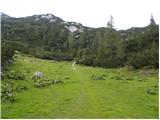 12
12 13
13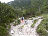 14
14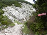 15
15 16
16 17
17 18
18 19
19 20
20 21
21 22
22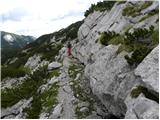 23
23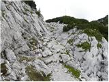 24
24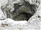 25
25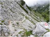 26
26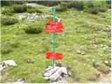 27
27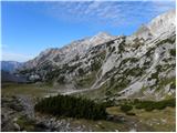 28
28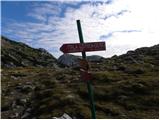 29
29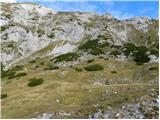 30
30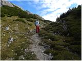 31
31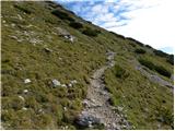 32
32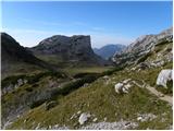 33
33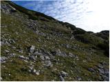 34
34 35
35 36
36 37
37 38
38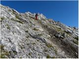 39
39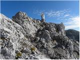 40
40 41
41
Discussion about the trip Planina Podvežak - Mala Ojstrica
|
| Peter-hribi29. 07. 2010 |
The path from Planina Podvežak is very nice, as you quickly rise above the forest line (for more comments see Planina Podvežak - Kocbekov dom na Korošici). The path from Sedelca ascends a nice grassy slope with beautiful views ... also from the summit to Robanov kot and surroundings.
Definitely a very nice and undemanding summit!
|
|
|
|
| eka15. 06. 2011 |
Is there still snow at this altitude now?
|
|
|
|
| petruša17. 06. 2011 |
From Planina Podvežak there is no more snow problem, here and there from Korošica to Ojstrica there are snow patches that can be avoided and at the top of Ojstrica there is still a little. No problem, you can go without issue, just safely and slowly. lp
|
|
|
|
| seinfeld12. 09. 2011 |
We did the trail on Saturday, September 10th, two adults, two children 9 and 11 years old. From Mala Ojstrica we went to Kocbekov dom, back to Planina Podvežak via Prag, past Vodotočno jezero, and via the saddle between Tolsti vrh and Deska, where there are no markers but the path is clearly visible. Altogether 13 km of trail, completed in just over six hours. The trail is wonderful, varied, scenic, with lots of karst phenomena. Only right at the top of Mala Ojstrica the legs shake a bit (for me). Recommended.
|
|
|
|
| gorskarozica19. 08. 2012 |
These days I visited Vodotočnik, Ojstrica, Mala Ojstrica, Molička peč. Shame on the one who came to Mala Ojstrica and stole the stamp that was attached to the chain. This is not a mountaineer, this person has no business in our mountains. Doesn't need the stamp, but caused damage to PD and us hikers! Otherwise the path is nice, thanks to our path markers. Otherwise the path is nice, thanks to our path markers.
|
|
|
|
| Stamp1. 08. 2016 |
Can one climb to Mala Ojstrica without problems directly from the east from the direction of Stara Kocbekova Koča and Church of Cyril and Methodius? thanks
|
|
|
|
| Stamp1. 08. 2016 |
Found out on forum.. Yes..
|
|
|
|
| golica4. 07. 2017 |
I'm inquiring about the following: from Podvežak I plan to Veliki vrh, Zelenica... is there then a marked path to Molička peč (chapel) from V. vrh or Zelenica down, I haven't seen that description, if one can descend because I would continue to Mala Ojstrica and to Korošica. Thanks for info
|
|
|
|
| otiv4. 07. 2017 |
The junction for Veliki vrh and Zelenica is from the Podvežak - Molička peč path, so just go back to the junction and continue towards the chapel and old Kocbek hut and from there to Mala Ojstrica and Ojstrica...
|
|
|
|
| golica4. 07. 2017 |
thanks a lot, yes that's the info I wanted. Regards
|
|
|
|
| kr ena28. 09. 2017 |
Is there a nice drivable road to Planina Podvežak?
|
|
|
|
| zlatica28. 09. 2017 |
Sure, was there 7.9. lp
|
|
|
|
| kr ena28. 09. 2017 |
How is the path to Mala Ojstrica, any snow?
|
|
|
|
| Blazz0914. 05. 2018 |
Yesterday we went on this trail.
The road to the starting point is in very good condition, possibly a bit torn up in places due to forest tractors. The beginning of the trail is very demanding due to hundreds of uprooted spruces. (probably storm)
There's quite a lot of snow in places, even more than 2m, starting 300m above the shepherd huts.
Unfortunately, we didn't reach the summit because we didn't dare cross the steep slope before the ascent to Mala Ojstrica.
The snow is melting incredibly fast, but in my opinion the trail is demanding and dangerous due to the snow.
|
|
|
To post a comment you must log in:
If you do not yet have a username, you must first
register.