Planina Podvežak - Ojstrica (via Kocbekov dom)
Starting point: Planina Podvežak (1500 m)
| Latitude/Longitude: | 46,33190°N 14,67260°E |
| |
Route name: via Kocbekov dom
Walking time: 4 h
Difficulty: difficult marked way
Elevation gain: 850 m
Elevation difference along the route: 1200 m
Map: Kamniške in Savinjske Alpe 1:50.000
Recommended equipment (summer): helmet
Recommended equipment (winter): helmet, ice axe, crampons
Views: 116.380
 | 9 people like this post |
Access to starting point:
First, we drive to Luče, then continue the drive into the Podvolovjek valley (direction Kamnik and Kranjski Rak). At the road marker between 11 and 11.5 km, we will arrive at a smaller intersection, where the road towards the farm Planinšek and mountain pastures Podvežak, Ravne and Vodole branches off to the right (the turn-off is marked). We head onto this initially still asphalted road, which we follow at the intersections in the direction of the mountain pasture Podvežak. After a relatively long (9.5 km) and in the upper part also worse macadam road, we will arrive at the parking lot below the mountain pasture Podvežak (at the starting point there is a barrier and numerous hiking signposts).
From Kamnik we drive towards the Črnivec pass, but only to the intersection where the road towards Kranjski Rak branches off sharply to the left (the turn-off is marked and is located only 500 m before the mentioned pass). At the intersection at Kranjski Rak we continue straight on the main road, which starts descending into the Podvolovjek valley. In the mentioned valley, only 100 m behind the Gams bar, we will arrive at an intersection where the road towards the farm Planinšek and mountain pastures Podvežak, Ravne and Vodole branches off to the left (the turn-off is marked). Further, follow the above description.
Route description:
From the parking lot, we head onto the footpath (or road) in the direction of the mountain pasture Podvežak. Both the road and the footpath, which during the ascent crosses the forest road, bring us in 15 minutes of moderate ascent to the shepherd's hut on the mountain pasture Podvežak, from which a beautiful view opens towards Rogatec and Lepenatka.
From the mountain pasture we continue on the marked but initially poorly visible path, which soon enters the forest. The path through the forest ascends somewhat more steeply, then transitions into a smaller unvegetated valley, above which it completely flattens. This is followed by a few minutes of traversing the slopes below the side ridge of Deska, then the path brings us to a less noticeable junction, where an unmarked path branches off to the left towards Deska and Vodotočno jezero. We continue straight on the marked path, which descends into a pleasant grassy plain, then turns somewhat to the right and ascends through a belt of dwarf pines. At the top of the ascent, the path from the mountain pasture Vodole joins from the right; we continue left, cross the pasture fence, and after a few more steps arrive at Inkretov studenec, which is located just a few meters from the path.
This is followed only by a gentle ascent, then the path flattens again and brings us below the relatively steep and in snow avalanche-prone slopes of Tolsti vrh. A little further, the pleasant path brings us to a marked junction, where we continue slightly left in the direction of Korošica (slightly right the chapel on Molička peč (mountain pasture)). The path ahead crosses the slopes below Tolsti vrh for some time, then transitions to the plateau-like terrain of Dleskovška planota, which is riddled with numerous sinkholes and caves. The path, continuing with some shorter ascents and descents, then quickly brings us to a junction where the path from Robanov kot and the mountain pasture Ravne joins from the right side.
We continue in the direction of Korošica on the path that ascends traversely to the saddle between the less known Koroški vrh on the left and Mala Ojstrica on the right. We continue straight downhill (left Prag, right Ojstrica via Mala Ojstrica) on the marked path, which starts descending towards Korošica. After a few minutes of descent we step onto the expansive grassy slopes of Korošica, along which we then walk in a few minutes to the mountain hut.
From Kocbekov dom we continue on the marked path in the direction of Ojstrica. The path already a few meters above the hut enters a belt of dwarf pines, where it gradually begins to ascend ever more steeply. After a good 20 minutes of ascent from Kocbekov dom the path flattens, transitioning to grassy slopes which are soon replaced by scree. The path ahead crosses two successive gullies, then begins to ascend more steeply on the increasingly panoramic slope. The path ahead leads past two less noticeable junctions (in both cases we continue right in the direction of Ojstrica, left Planjava and Škarje) and gradually begins to turn further to the right. Higher up the path becomes even steeper and transitions to a quite scree-covered slope. Further on the path flattens briefly and brings us through a narrower passage to the main ridge of the Kamniško-Savinjske Alpe. Once on the ridge we continue right on a very steep path, which further ascends through rugged rock. We follow this very steep path, aided by a few pegs, all the way to the summit of Ojstrica, which we reach after approximately 15 minutes of further walking (in the final section there is a high risk of falling rocks).
planina Podvežak - Korošica 2:15, Korošica - Ojstrica 1:45.

Photos:
 1
1 2
2 3
3 4
4 5
5 6
6 7
7 8
8 9
9 10
10 11
11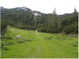 12
12 13
13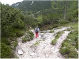 14
14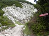 15
15 16
16 17
17 18
18 19
19 20
20 21
21 22
22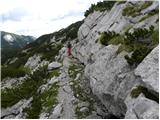 23
23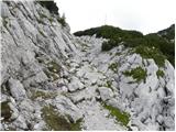 24
24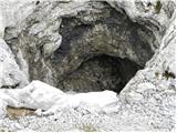 25
25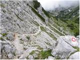 26
26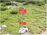 27
27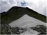 28
28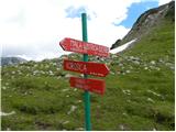 29
29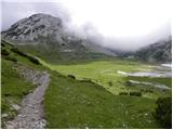 30
30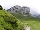 31
31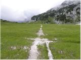 32
32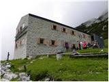 33
33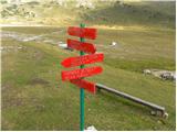 34
34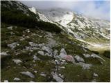 35
35 36
36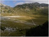 37
37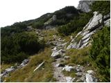 38
38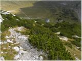 39
39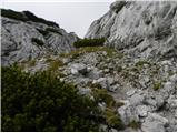 40
40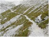 41
41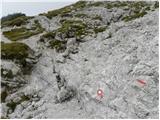 42
42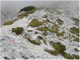 43
43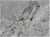 44
44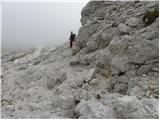 45
45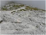 46
46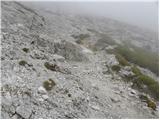 47
47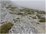 48
48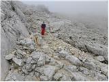 49
49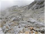 50
50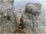 51
51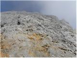 52
52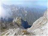 53
53 54
54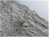 55
55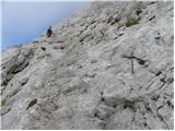 56
56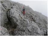 57
57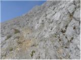 58
58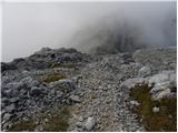 59
59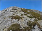 60
60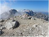 61
61
Discussion about the trip Planina Podvežak - Ojstrica (via Kocbekov dom)
Show older messages
|
| Gost19. 07. 2007 |
Sorry!
Not through Kocbekov dom, but past Kocbekov dom.
|
|
|
|
| Gost24. 07. 2007 |
We stayed overnight at Kocbekov dom this weekend, the service was REALLY friendly!! All praise to the hostess 
|
|
|
|
| Gost27. 07. 2007 |
I don't agree, the offer is poor, soup very thin and too lukewarm
|
|
|
|
| andrej76730. 07. 2007 |
what bothers me more is that they don't have really cold beer - it's more lukewarm than the soup I read about well, it'll be ok.
|
|
|
|
| jurs25. 08. 2007 |
It's sad when you reach the top of Ojstrica but there's no logbook or stamp! Kocbekov dom is just fine though, I got an ice-cold beer!
|
|
|
|
| Gost2. 09. 2007 |
At the top of Ojstrica there is no summit logbook, but there is definitely a stamp (1.9.07). We too were treated to friendly service and cold beer at Kocbekov dom.
|
|
|
|
| Gost3. 09. 2007 |
Only criticisms about soups and beer and..., but nowhere any praise for the people who try to make hikers feel comfortable in the mountains.
|
|
|
|
| Gost3. 09. 2007 |
We read about the lukewarm soups etc. Well, the food is tasty. We ate ričet and pasta with beans, both very good. We haven't eaten such tasty one-pot dishes for a long time. Thanks to the staff, your faithful Celjani!
|
|
|
|
| Gost14. 09. 2007 |
The stamp is at the top. On almost all summits now the stamps are "set in concrete" and no longer in a box.
|
|
|
|
| simonaplanina18. 07. 2008 |
It was one of the nicer outings, varied landscape. From Kocbekov dom to Ojstrica quite a steep path. Those who like climbing on rocks will be thrilled! Return along the ridge past Mala Ojstrica is a feast for the eyes, views left and right. Overall super!
|
|
|
|
| vojko17. 10. 2008 |
The hut is closed for this year. If anyone goes to Ojstrica, count 6 hours from the hut and back.
|
|
|
|
| urosl12. 10. 2008 |
Today we were on Ojstrica. We had excellent weather, and some luck too, as we found the hut at Korošica open, too bad there was no more Laško and we had to drink Union
Otherwise first league!!!
|
|
|
|
| proplayer1118. 08. 2009 |
So the path is a bit steep but nowhere exposed?
|
|
|
|
| gasilec8. 08. 2009 |
Indeed, the path from Kocbekov dom to Ojstrica has no exposed sections, but towards the top it's a bit gravelly - caution on descent!
|
|
|
|
| Lisa10. 08. 2009 |
Hello firefighter,
Please tell me which is the better variant for descent from Ojstrica??? I heard that towards Kocbekov dom it's not exactly!?
Thanks for the answer
|
|
|
|
| geppo10. 08. 2009 |
Sorry to interrupt Lisa!
Depends on where you're headed and from where you approached the summit?
DESCENTS
- Korošica
- Škarje and Klemenčeva jama
- Škarje and then Planjava
- Kopinškova ( demanding!! )
Regards
|
|
|
|
| Lisa14. 08. 2009 |
Hi Geppo,
Sorry for the slightly late reply  . .
Yes, that's it....we're going on Sunday from the direction of Korošica. We'll probably descend back to Korošica too. What do you suggest?  Please note we're a group prone to vertigo, so various exposed narrow sections aren't the best choice. Please note we're a group prone to vertigo, so various exposed narrow sections aren't the best choice.
Otherwise I'm familiar with those paths up there you listed. Kopinškova definitely out of the question.
Ciao
|
|
|
|
| gasilec14. 08. 2009 |
Lisa - if returning to Korošica, I suggest descending the same path you'll ascend (southern path from Kocbekov dom), as it'll already be familiar.
Another option is descent via Mala Ojstrica (see portal description!), but it probably won't suit you (right at the start need to scramble a bit, if you manage that the rest is no problem).
And one more thing - the easiest approach to Ojstrica is exactly the path past Kocbekov dom, as mentioned no pronounced exposed sections, but be prepared at the saddle for the first vertigo view into Logarska dolina!
If your group is physically prepared and properly equipped, the planned tour is quite suitable, so boldly on the way!
Best regards!
|
|
|
|
| Lisa15. 08. 2009 |
Fireman, thank you, you explained this to me briefly and nicely!.
Yes, we'll go from Korošica and return here too. Mala Ojstrica also appeals to me, but it wouldn't be suitable for one person at all, so.. where up-there down.
Thank you once again for your insightful explanation.
Good luck!
|
|
|
|
| Mirko0118. 08. 2009 |
Yesterday I was on Ojstrica (starting point parking lot below Planina Podvežak. For quite some time I didn't know if I was at the right starting point. When I returned, I saw others were also confused. Therefore, I would supplement the starting point description.
"After a relatively long (addition 1: 9.5 km) and in the upper part also worse gravel road, we arrive at the parking lot below Planina Podvežak (at the starting point there is a barrier and numerous alpine signs)." Addition 2: "The most noticeable sign is for Mališka planina. On the side is a sign for Korošica by road. The marked footpath to Korošica is by the wooden shed."
|
|
|
|
| PUHI18. 08. 2009 |
Maybe this doesn't belong here, but a somewhat easier access is from Planina Ravne, which is a higher starting point, clearly visible on the map and also signposted at junctions. From the hut on Pl. Ravne, go another 1 km to the end of the road by car, then on foot around Dleskovec towards V. vrh and along its foot towards the path coming from Planina Podvežak. In short, there are many nice variants on the Dleskovška planota. Best regards.
|
|
|
|
| mojcej'7215. 08. 2010 |
On Tuesday 10.8. we did with my 9-year-old daughter the tour Planina Podvežak - Kocbekov dom, ate something, observed the construction of the new helipad for 2 hours, then decided also for a trip to the top of Ojstrica, due to approaching clouds we didn't hesitate with descent. Together with about 20 Czechs we overnighted, admired the sunset and then sunrise in the morning and slowly headed back down on Wednesday. Super trip!
|
|
|
|
| ZOJA2. 10. 2010 |
Hello hikers!
I'm curious about the path to Planina Podvežak? Is the hut open at Korošica? Is there any snow on Ojstrica yet? Please reply as soon as possible, as we plan to head to Ojstrica tomorrow.Best regards
|
|
|
|
| jprim2. 10. 2010 |
If you check the Alpine Association of Slovenia, you have info on huts, now marked OSPN, open Saturdays, Sundays, holidays, which probably means it's open tomorrow since the weather is fine too, otherwise there are phone numbers so you can call, regarding the road I don't know how it is now after this rain, but I think there shouldn't be problems, the road is gravel about 14 km, need to be careful, advice, if the car is low and loaded, it might scrape the undercarriage somewhere.
We're also planning Ojstrica for tomorrow ... or ...
Best regards!
|
|
|
|
| ZOJA2. 10. 2010 |
Thanks, jprim. And where are you coming from?
|
|
|
|
| vkl27. 06. 2011 |
Hi,
I'm wondering if the path to Ojstrica is also suitable for a dog? From the pictures, it seems more no than yes.
lp
|
|
|
|
| Paintball27. 06. 2011 |
If anywhere, then this path to Ojstrica is also suitable for a dog, the others in my opinion are not. From Korošica to the top it's practically only scree, which is steep but I think it's doable. There are no overhangs or difficult sections secured with pegs or cables on the path.
|
|
|
|
| vkl27. 06. 2011 |
thanks for the help.
|
|
|
|
| jvali12. 08. 2011 |
ju3 I would go with my husband to Ojstrica. I read all statements and descriptions of both paths (from Korošica or through Little Ojstrica). We like to go up one way, down another. What do you suggest: up through Little Ojstrica, because it's a quick ascent and easier to climb up than down and then descent towards Korošica? This year we have already been to Grintovec and Storžič through Žrelo, two days ago I was also at Krofička. So, is Ojstrica a suitable choice?
|
|
|
|
| otiv12. 08. 2011 |
Of course it is, just be early, because thunderstorms are forecast for the afternoon. Definitely first up Kocbek's path to the top and then down the easier one from Ojstrica towards Korošica.
Good luck!
|
|
|
|
| jvali12. 08. 2011 |
otiv: thanks. the weather should hold, at least that's what it looks like on the net. but it's true, in the mountains you never know.
|
|
|
|
| kristijan15. 08. 2011 |
I just returned from Ojstrica, back to the summit from the hut via Kocbek's path to the Podvežak valley. Nice path, not too strenuous, well marked. Only someone should bring a stamp pad, there isn't one at the top, so you improvise something, and I have the feeling that there won't be many stamps anymore
|
|
|
|
| Sam.volk15. 08. 2011 |
A real mountaineer has a stamp pad in the backpack.lp
|
|
|
|
| IgorZlodej15. 08. 2011 |
I know more and more such people for whom the stamp is the last thing when hiking in the mountains
|
|
|
|
| GregorC15. 08. 2011 |
I rarely collect stamps, but if I do, the stamp pad is always in the backpack. I always have the stamp with me anyway.
|
|
|
|
| otiv15. 08. 2011 |
With age, the passion for collecting stamps fades a bit, only the desire for beautiful experiences among the mountains remains.
|
|
|
|
| Marta15. 05. 2012 |
On Tuesday we went to Ojstrica past Kocbekov dom. Up to Sedelce there is still quite a bit of snow on the path, which sinks in places. The track we followed went straight through the scree several times, we climbed through the blueberries. Gaiters might come in handy.
|
|
|
|
| ŽigaB29. 06. 2012 |
Did the described path in two stages, the hostess at Kocbekov dom is exceptionally friendly and obliging, the path is wonderful, the logbook at Ojstrica so full that even all covers are written on... And a tip: if you stay on Korošica a day longer, I recommend also a jump to Lučkega Dedca (2023m), short but interesting tour.
|
|
|
|
| juhejnaprej7. 07. 2012 |
Today I went from Planina Vodole over Mala Ojstrica to the summit of Ojstrica, then past Kocbekov dom back between Tolsti and Črni vrh towards the starting point. The weather was excellent, we met quite a few people, and on the return around 3 pm we watched a helicopter rescue slightly below the summit on the side towards Škarje. There were lots of people on the ridge, and the helicopter circled the area for about an hour. Maybe someone knows what happened?
|
|
|
|
| planinka eva22. 08. 2012 |
today I was on Ojstrica up I went via Mala Ojstrica back via Kocbekov dom the path is excellent maybe it could have a few more pegs in places but still it's great
|
|
|
|
| dima3. 09. 2012 |
I'm curious what the macadam to Planina Podvežak is like? Thanks everyone for the info :-)
|
|
|
|
| Gizmo3. 09. 2012 |
I drove this road about 3 weeks ago. The road is especially in the upper part quite damaged, but it's passable. Slowly and carefully, where there are shallow ditches across the road. Sometimes you have to drive diagonally too, otherwise the car's underbody can touch the ground, which I don't recommend, given that large stones stick out in places.
Good luck...
|
|
|
|
| pohodnica535. 09. 2012 |
dima@ the road is fully passable, we've been there 2x in the past 3 weeks, but I agree with Gizmo that you really need to drive slowly and carefully; last time the parking was full to the last spot, and quite a bit along the road up and down, which surely wouldn't be the case if the road were a bigger issue; it's very nice "up there", don't let the macadam fear stop you;lp
|
|
|
|
| Gizmo5. 09. 2012 |
Pohodnica53 I second that statement. It really is nice up there. Queen Ojstrica beckons. The road surely won't be an obstacle.
Happy trails.
|
|
|
|
| Saš196728. 07. 2013 |
Yesterday we did this wonderful tour. The parking lot was already almost full at eight in the morning. We headed to Korošica via the path past Deska and Vodotočnik, which took us a bit more than two hours. We returned via Sedelce and past Inkretov studenec, completing a nice loop. The markings to Korošica are renewed, but towards the top of Ojstrica they are already quite faded. The caretaker at Korošica kindly provided all the information. Also thanks to two friendly hikers at the top who lent us the ink pad for the stamp, otherwise our son would have been without the desired stamp.
|
|
|
|
| tamea27. 10. 2013 |
Hello,
today on the path between Korošica and Ojstrica I lost my phone (Motorola flip with pink cover). Presumably it was left on the southern clearing by Kocbekov dom. If anyone finds it, please write to matejka.z@gmail.com
|
|
|
|
| Borut129. 08. 2014 |
Hello, what's the road to Planina Podvežak like?
|
|
|
|
| Keko29. 08. 2014 |
Solid and normally drivable.
|
|
|
|
| jesen29. 08. 2014 |
Yesterday (28.8.2014) shortly after the junction I came across a sign (something like): due to logging the road is closed. Open at 10, 12 and 14 o'clock. Nevertheless, I continued and actually encountered the barrier. The friendly gentleman allowed me to pass. Just so you know. All the best!
|
|
|
|
| nordkap21. 09. 2014 |
Is there still a notice up to the mountain pasture regarding cutting and transport times, or is it now normally open, I mean around 6:00 a.m. or earlier.
So we don't drive in vain and then transport wouldn't be possible.
How is it now with that?
|
|
|
|
| nordkap21. 09. 2014 |
And one more thing, how is it now with the stamp at Ojstrica, is there one and where?
|
|
|
|
| MPS7. 05. 2015 |
On Sunday 10.5. I plan to go to Ojstrica via this route, so I'm wondering about the snow? Is there still a lot? Thanks for the reply. Best regards
|
|
|
|
| Grenaleva8. 05. 2015 |
last year there was snow until the end of June up to Cojzove, but well trodden, this year from afar it looks significantly less and the summit almost snow-free - and a hiker just reported conditions on Kalški greben at 2224 m.a.s.l. and photographed that it is bare
|
|
|
|
| MPS9. 05. 2015 |
Thanks Grenaleva and klemenb for the reply! We'll try it!
|
|
|
|
| Mark014. 06. 2015 |
I just got back from the hike, really nice tour, but the fresh laid asphalt on the road to the starting point nicely surprised me. They did a great job, you glide on the asphalt like on butter, well except the last 5 km, those you just endure a bit. As I heard, the road used to be awful.
At the top of Ojstrica there is only a worn triangular stamp, so I stamped a smudge in the logbook, the hut keeper below in the hut said they took it away the last Sunday of the previous season  . The hut keeper is very friendly, lots of hikers, great views, recommended! . The hut keeper is very friendly, lots of hikers, great views, recommended!
|
|
|
|
| alpin14. 06. 2015 |
Then a bike tour will also be possible with a fully, since there's asphalt!!
|
|
|
|
| Jurcekk1. 07. 2015 |
Hello! We're just filling the booklet and heading to Ojstrica.. How is it now with the stamp, is there or not? If not at the top, is there at least at the hut on the ridge from the top of Ojstrica? lp
|
|
|
|
| garmont9. 07. 2015 |
In this path description, the only significant descent worth mentioning is from Sedelca (1900m) to Dom na Korošici (1808m), so the total elevation difference is at most 150m and not 350m as in the description.
|
|
|
|
| Tadej11. 07. 2015 |
Thanks for the warning, I've corrected it. Best, Tadej
|
|
|
|
| Zdenkob31. 07. 2016 |
Was on Ojstrica yesterday. Gorgeous weather, lots of people, but beautiful views and pleasant atmosphere. The path to Planina Podvežak is now really better, only the last 4 km are still gravel.
|
|
|
|
| Stamp1. 08. 2016 |
Can one climb to Mala Ojstrica without problems directly from the east from the direction of Stara Kocbekova Koča and Church of Cyril and Methodius? thanks
|
|
|
|
| Stamp1. 08. 2016 |
found out on forum.. possible
|
|
|
|
| awirex6. 08. 2016 |
Was on Ojstrica today. Very bad weather at the summit, thick fog and strong wind. Most hikers turned back. At the top there's a problem with the stamp as it's very worn, so only the outline is visible and even that requires hard pressing. In Kocbekova koča the staff is friendly.
|
|
|
|
| DarkoZ8. 08. 2016 |
Yesterday on the summit it was similar, no views and windy.
|
|
|
|
| rodica3. 07. 2017 |
Can someone tell me what the condition of the road to Podvežak is like, please.
|
|
|
|
| geppo3. 07. 2017 |
I didn't drive there. A colleague was two days ago. No special issues, occasional ditch from downpours. As usual.
regards
|
|
|
|
| Hribolazec8124. 06. 2018 |
Hello, how about the stamps from Kocbekov dom, can they still be obtained? I plan to go to Ojstrica these days.
|
|
|
|
| maks5729. 06. 2018 |
Regarding the Kocbekov dom stamp, I'm also interested in where to get it. And I will be very grateful for the answer.
|
|
|
|
| NYG1. 07. 2018 |
There is no stamp at Korošica.
If PZS were a serious organization, they would have ensured by 1 July that the stamp is up there for this largest Slovenian long-distance trail. But I can't say I'm surprised, given PZS's attitude to SPP in the past period.
|
|
|
|
| garmont1. 07. 2018 |
The stamp is exclusively the responsibility of the PD managing the hut, in this case Celje - Matica. PZS has nothing to do with it.
That the Dom na Korošici is part of SPP is of the greatest interest to the mentioned mountaineering club, as it increased traffic to the hut this way.
Of course, when it was still standing.
|
|
|
|
| NYG1. 07. 2018 |
That's how it is in practice, yes, PZS has determined the control points, everything else is left to the clubs. A bit more activity from PZS wouldn't hurt.
|
|
|
|
| maks571. 07. 2018 |
Today we were at Ojstrica. Of course we didn't get the Kocbekov dom stamp. At the place where the stamp should be, I already entered today's date. For me the matter is clear and it doesn't even occur to me to repeat this tour because of the sloppiness of certain responsible people. It is really ridiculous, unacceptable and inadmissible that from 20 October last year, when the hut burned down, until today, no one has taken care of the stamp. About the ruins of the hut, which I can only understand as a great shame, I might speak on the forum and attach some photos I took today?
|
|
|
|
| Mara6619. 04. 2019 |
Nice greetings,
We are planning a hike to Korošica and further to Ojstrica and back. We are interested in the conditions on Ojstrica? Snow? So we can prepare.
Regarding the stamp at Korošica. How is that?
Thanks
|
|
|
|
| garmont19. 04. 2019 |
There is of course still a lot of snow on the trail to Ojstrica, so no comment on necessary equipment.
The SPP stamp was last year in Orlovo gnezdo at Rinka waterfall, where Mojca brought it.
|
|
|
|
| Blazina29. 10. 2019 |
On Saturday I was on Ojstrica. There was no summit register at the top.
|
|
|
|
| ljubitelj gora2. 01. 2020 |
On Ojstrica 2.1, up to around picture 50 it was fine to walk. Further on pure icy conditions. Climbed a bit more but it was a bit risky (standard gear) and turned back a little, traversed to the SW ridge and up it to the summit. Returned via SW ridge then under the Ojstrica wall towards Mala Ojstrica. In the evening conditions change, snow freezes before sunset and ice starts falling from the walls.
http://shrani.si/f/24/13g/a7dOEXU/img2285.jpg
http://shrani.si/f/a/69/mTnPIOf/img2289.jpg
[img>http://shrani.si/f/1G/X/3PMiTg1t/img2304.jpg[/img]
|
|
|
|
| Amadeja11. 06. 2022 00:41:42 |
Hey, on Sunday I plan to go to Ojstrica. Has anyone been to the summit recently and can tell if there's still any snow?
|
|
|
|
| ovi3. 07. 2023 15:36:25 |
...a year and a month (almost) later - how is the access (road) - is the walking time realistic for the averagely experienced? Is it possible to take a dog ("Pohorski serpentinar") along?
thanks for answers - safe steps!
btw. watched videos from You..ba - they say it goes - but not easily (avoiding Male Ojstrice)...
|
|
|
|
| Muškercva4. 07. 2023 09:05:23 |
@above
The road is normally drivable - nicely maintained. The time can, at normal pace, perhaps be shortened by half an hour/hour. Years ago I went to the top with my little dog. This Sunday I met two who went to the top with a dog (for a 'mountain' dog it shouldn't be too difficult).
Good luck!
|
|
|
|
| ovi4. 07. 2023 18:33:06 |
Thanks. Let's see ;-)- this weekend, btw...
|
|
|
|
| Jusk4. 07. 2023 20:56:27 |
Guys, it's enough if you write under one path that you're going. Unless you're going multiple paths at once
|
|
|
|
| garmont7. 07. 2023 12:37:12 |
With the attached post, you told us that your two guides haven't done the necessary scouting trips. If you think that a scouting trip can be replaced by Googling... you're mistaken.
|
|
|
|
| ovi7. 07. 2023 15:13:25 |
you are partially right; but you "skipped" the point: one would expect (if Google "throws up" the main mountaineering website (besides PZS's) slightly more up-to-date data (that's why the forum - if nothing else, admin should contact mountaineering societies at least a few times a year about access to starting points) - is that too difficult? Obviously.
and - the guy is right - can you please attach relevant (as much as possible) links where visitors can get updated data on trail conditions, impassability/inaccessibility of roads, landslides etc.?
Don't get me wrong - constructive criticism.
Safe steps /btw - they are not our guides - I'm from MB and not a member of PZS or any society...
|
|
|
|
| ovi7. 07. 2023 16:07:00 |
addition (many don't know) - to be "first choice in the Google search engine, you have to pay for it - and not a little - so one would expect such a website to offer updated data - after all, they can be misleading and rescue operations follow (God forbid injuries - even death of hikers who blindly trust what's written).
Isn't it true?
I'll report on Monday - will it go through, admin?
|
|
|
|
| Jusk7. 07. 2023 20:24:09 |
Yeah bravo, for every described trail up here you'd want completely fresh data on the entire trail, from start to finish for every meter of path?? Good luck what about so-called scouting trips to familiarize yourself with the path? come on admin? By Monday get this sorted
|
|
|
|
| balon8. 08. 2023 13:34:58 |
Hello,
I plan to go to Ojstrica. I'm interested if there are any changes/obstacles...on the path to the destination? Is the road to the starting point drivable???
Thank you for the answers.
Balon
|
|
|
|
| Enka8. 08. 2023 16:34:24 |
How do you plan to get to the starting point?
|
|
|
|
| Kafetarca8. 08. 2023 20:12:44 |
Enka, Balončka is also interested in that, whether he can even get to the starting point. It's too much work to check promet.si himself, so he'd rather ask on the mountains.
Balon, for now it seems that visiting Ojstrica will either be unfeasible or a very very long and strenuous journey from Suhadolnik.
|
|
|
|
| Enka8. 08. 2023 23:46:49 |
Kafetarca, I fear he hasn't even thought about the fact that currently no road leads to this area. He was interested in the road to Planinšek and further to Podvežak.
|
|
|
|
| balon9. 08. 2023 08:39:52 |
Hello,
thank you both for the answers. Enka, that's what interested me, the road from Planinšek to Podvežak. We'll postpone the adventure.
|
|
|
|
| Enka9. 08. 2023 10:01:36 |
Balon, since I see you're asking in other threads too (by the way, questions about current conditions belong in the forum called that way - Current Conditions, and not here in path descriptions): Kamnik-Savinja Alps are (and will be for some time) accessible only from the western side (Jezersko, Kokra valley, via Krvavec).
|
|
|
|
| balon9. 08. 2023 11:54:37 |
Thanks for the info. I asked in other threads because I was interested if it's passable or not. In the future I'll check under Current Conditions.
|
|
|
|
| 12a3bc6. 08. 2024 00:34:46 |
Has anyone gone up this path recently? Is the path in good condition? Do you recommend this path more for ascent or descent?
|
|
|
|
| garmont6. 08. 2024 09:53:31 |
Usually used for descent, although the path over Mala Ojstrica is not much more demanding either.
There are no peculiarities on either path.
|
|
|
|
| Tina A. 8017. 10. 2025 17:45:38 |
Is this path completely dry after the snowfall two weeks ago?
|
|
|
|
| felix19. 10. 2025 11:14:22 |
If not too late, yesterday I was in the area, snow aplenty in some hollow. Lp
|
|
|
To post a comment you must log in:
If you do not yet have a username, you must first
register.