Planina Podvežak - Ojstrica (via Mala Ojstrica)
Starting point: Planina Podvežak (1500 m)
| Latitude/Longitude: | 46,33190°N 14,67260°E |
| |
Route name: via Mala Ojstrica
Walking time: 3 h 30 min
Difficulty: difficult marked way
Elevation gain: 850 m
Elevation difference along the route: 900 m
Map: Kamniške in Savinjske Alpe 1:50.000
Recommended equipment (summer): helmet
Recommended equipment (winter): helmet, ice axe, crampons
Views: 257.480
 | 14 people like this post |
Access to starting point:
First, we drive to Luče, then continue the drive into the Podvolovjek valley (direction Kamnik and Kranjski Rak). At the road marker between 11 and 11.5 km, we arrive at a smaller intersection, where the road towards the farm Planinšek and mountain pastures Podvežak, Ravne and Vodole branches off to the right (the turn-off is marked). We head onto this initially still asphalted road, following it at intersections in the direction of the mountain pasture Podvežak. After a relatively long and in the upper part also worse macadam road, we arrive at the parking lot below the mountain pasture Podvežak (at the starting point there is a barrier and numerous hiking signposts).
From Kamnik we drive towards the pass Črnivec, but only to the intersection where the road towards Kranjski Rak branches off sharply to the left (the turn-off is marked and is located only 500 m before the mentioned pass). At the intersection at Kranjski Rak we continue straight on the main road, which starts descending into the Podvolovjek valley. In the mentioned valley, only 100 m past the Gams bar, we arrive at an intersection where the road towards the farm Planinšek and mountain pastures Podvežak, Ravne and Vodole branches off to the left (the turn-off is marked). Continue as per the description above.
Route description:
From the parking lot, we head onto the footpath (or road) in the direction of the mountain pasture Podvežak. Both the road and the footpath, which during the ascent crosses a forest road, bring us in 15 minutes of moderate ascent to the shepherd's hut on the mountain pasture Podvežak, from which a beautiful view opens towards Rogatec and Lepenatka.
From the mountain pasture, we continue on the marked but initially poorly visible path, which soon enters the forest. The path through the forest ascends somewhat more steeply, then transitions into a smaller unwooded valley, above which it completely flattens. This is followed by a few minutes of crossing the slopes below the side ridge of Deska, then the path brings us to a less noticeable junction, where an unmarked path branches off to the left towards Deska and Vodotočno jezero. We continue straight on the marked path, which descends into a pleasant grassy plain, then turns somewhat to the right and ascends through a belt of dwarf pines. At the top of the ascent, the path from the mountain pasture Vodole joins from the right; we continue left, cross the grazing fence, and after a few more steps arrive at Inkretov studenec, which is located just a few meters from the path.
This is followed only by a gentle ascent, then the path flattens again and brings us below the relatively steep and in snow avalanche-prone slopes of Tolsti vrh. A little further, the pleasant path brings us to a marked junction, where we continue slightly left in the direction of Korošica (slightly right the chapel on Molička peč (mountain pasture)). The path ahead crosses the slopes below Tolsti vrh for some time, then transitions to the plateau-like terrain of Dleskovška planota, which is riddled with numerous sinkholes and caves. The path, continuing with some shorter ascents and descents, quickly brings us to a junction where the path from Robanov kot and the mountain pasture Ravne joins from the right.
We continue in the direction of Korošica on the path which ascends transversely to the saddle between the less known Koroški vrh on the left and Mala Ojstrica on the right.
From Sedelce (1900 m) we continue right on Kocbekova pot in the direction of Ojstrica and Mala Ojstrica (straight down Kocbekov dom na Korošici). From the saddle, the path first gently descends across a pleasant grassy slope, then turns right, where it begins to ascend transversely towards the east. After a short ascent, the path brings us to the ridge of Mala Ojstrica (here the path from Molička planina joins from the right), where it turns sharply left and continues ascending along a very panoramic ridge. The path, which further ascends along the left side of the ridge, brings us in a few more minutes of walking below the indistinct summit of Mala Ojstrica, which we recognize by the miniature Aljažev stolp (ascent to Mala Ojstrica is just one minute from the path). The marked path bypasses the mentioned summit on the left side and a little further brings us back to the ridge, where we cross steep and slippery-prone slopes. Further, the path withdraws from the ridge to the left, crosses a short very steep slope, then emerges onto pleasant grassy slopes. After a few minutes of pleasant walking, we enter a short crumbly but not too steep section of the path. Further, the path flattens again, crosses another grassy slope, then in a moderate ascent over an increasingly rocky slope brings us below the summit slope of Ojstrica. The path ahead begins to ascend steeply through rugged rocky terrain and starts turning increasingly to the left. Further, the path gently flattens, crosses very steep slopes, then with the aid of pegs begins to ascend steeply again. The path, which provides numerous (mainly) natural holds, soon brings us below the fore-summit, from which follows a relatively difficult descent into the notch between the two summits. From the notch follows a short steep ascent over a crumbly slope, and the increasingly panoramic path quickly brings us to the summit of Ojstrica.
Planina Podvežak - Sedelce 2:00, Sedelce - Ojstrica 1:30.

Photos:
 1
1 2
2 3
3 4
4 5
5 6
6 7
7 8
8 9
9 10
10 11
11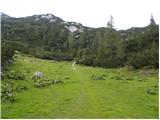 12
12 13
13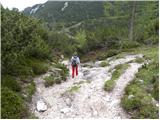 14
14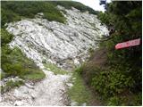 15
15 16
16 17
17 18
18 19
19 20
20 21
21 22
22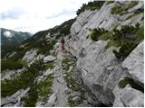 23
23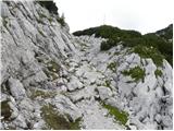 24
24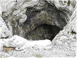 25
25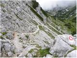 26
26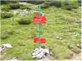 27
27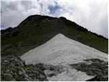 28
28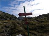 29
29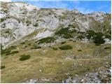 30
30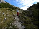 31
31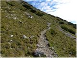 32
32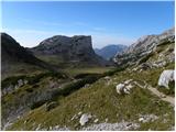 33
33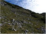 34
34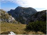 35
35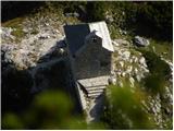 36
36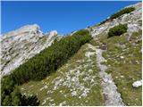 37
37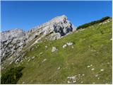 38
38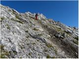 39
39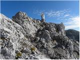 40
40 41
41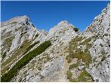 42
42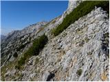 43
43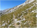 44
44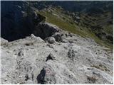 45
45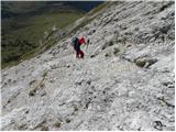 46
46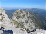 47
47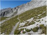 48
48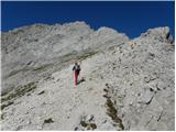 49
49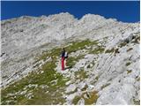 50
50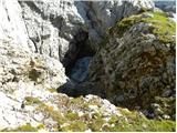 51
51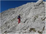 52
52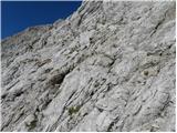 53
53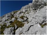 54
54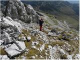 55
55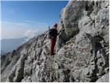 56
56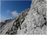 57
57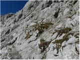 58
58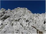 59
59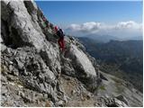 60
60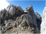 61
61 62
62 63
63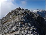 64
64 65
65
Discussion about the trip Planina Podvežak - Ojstrica (via Mala Ojstrica)
Show older messages
|
| Gost3. 09. 2006 |
Whoever decides to start from Planina Podvežak will find a beautiful and interesting path to Korošica, mostly through scree. Note that to the starting point just below Planina Podvežak there is about 1.5 km of narrow asphalt road and another 8 km of gravel. The gravel road is not like the one to Velika Planina. Watch for protruding rocks from the ground, and prepare for stones hitting the undercarriage. I do not recommend it at all for a car with very low ground clearance.
The path to Ojstrica via Mala Ojstrica or directly from Korošica is quite poorly secured. Be aware that the last 300-500 m (depending on direction) below the summit requires climbing several poorly secured rocky sections. The direct path from Korošica leads straight into the wall and rocks, while the path via Mala Ojstrica continues through scree for a while. Most hikers who don't want to ascend and descend the same path choose ascent from Korošica and descent via Mala Ojstrica. Of course, in the style: easier to climb rocks up than down. :)
In short, Ojstrica is definitely not suitable for Sunday excursionists, but those sufficiently prepared will be more than thrilled with the view in good weather. Less fit hikers will probably be happy just with the 'trip' from Planina Podvežak to Korošica.
|
|
|
|
| Gost5. 09. 2006 |
Nice not too strenuous but not too demanding tour. To me, only the last 10 min were demanding, where you have to climb a bit on steep exposed terrain (slowly and carefully it goes). When the path reaches the eastern ridge of Ojstrica it's a bit less recognizable so we must watch the marks (there are enough thank God) and know that the path always follows the ridge top, or runs just a few meters below the ridge on the south side.
|
|
|
|
| Gost24. 05. 2007 |
It would be nice if someone described the path from Logarska as well, past the koča at Klemenči jami, then via Kopinškova pot to the summit of Ojstrica, I think this path is very interesting and worth mentioning. Unless this site is meant only for Ljubljančani and surroundings, then I understand and hope the domain changes to www.hribi-ljubljana.net. Best regards!
|
|
|
|
| Tadej24. 05. 2007 |
Every registered website visitor can describe hikes. Otherwise, we also venture into Styria and Carinthia, perhaps less frequently but descriptions from that area will be published gradually. Best regards
|
|
|
|
| Gost14. 09. 2007 |
Last time I went to Ojstrica from Logar Valley past Klemenčeva Cave, up Kopinškova Path, we returned via Škarje. Altogether about 8 hours of pure walking. Quite long. Otherwise, Kopinškova Path is extremely beautiful, well secured.
|
|
|
|
| Gost17. 10. 2007 |
MT-Path from Planina Podvežak to Mala Ojstrica nice, further along the ridge well marked, for the last meters to the summit some skill required in places. Shoes with good grip recommended. Return to Kocbekov dom without issues. Well marked. (21.6.2007)
|
|
|
|
| Gost23. 10. 2007 |
The path from Robanova planina is also very well secured, and very adrenaline-pumping, at least I found it so! I recommend it but be careful, because in the early morning hours it's very slippery until the sun hits it! I walked it in summer time. Best regards
|
|
|
|
| Bizy28. 07. 2009 |
As already described in one of the comments, this path requires some skill only in the last 10 minutes to the summit. Otherwise no problems. On Mala Ojstrica there is a mini Aljažev stolp, right behind it the north wall and slopes towards Logarska and Robanov kot, super view, scenic.. From Ojstrica the easiest return is downhill towards Korošica, making a nice circular route. From Ojstrica the easiest return is downhill towards Korošica, making a nice circular route.
|
|
|
|
| mukica28. 07. 2009 |
We hiked the trail on Sunday. Nice day with wonderful views, caution needed towards the top, wonderful hike.
|
|
|
|
| acjom28. 07. 2009 |
What about the path to Planina Podvežak?
|
|
|
|
| mukica28. 07. 2009 |
You probably mean the road, which is well maintained, with a smaller car slowly no problem. Maybe at about three places more caution is needed so you don't get stuck.
|
|
|
|
| acjom28. 07. 2009 |
Thanks, yes I meant the road to the planina.
|
|
|
|
| beton8. 08. 2009 |
I'm going tomorrow, so I'll see
|
|
|
|
| upanje13. 08. 2009 |
Hello. Does anyone know at what time the mass is on Moliški peči on Saturday, 15.8.09. Thanks.
marjeta
|
|
|
|
| spelii15. 08. 2009 |
Today I took this path to Ojstrica and I have to say it's fantastic. Wonderful views From Ojstrica I returned via another path that leads to Kocbekov dom on Korošica.
There were tons of people at the summit, and also at Kocbekov dom, where they had a soccer tournament.
|
|
|
|
| Pohodnik1112. 09. 2009 |
I took the same route as described and find it a very nice and easy trail. The trail is only partially difficult on the way to the summit, in the last few minutes. The descent to Korošica doesn't seem dangerous to me, as there are no cliffs anywhere. Recommended!
|
|
|
|
| šerpa2. 09. 2009 |
I join the opinion of Pohodnik111. The trail is a bit more demanding only in the upper part, last 10 minutes or so somewhat more dangerous due to stonefall from hikers, say in the last 150 meters below the summit. Highly recommended helmet. When my wife and I were up there (30.8.), a hiker about 15 meters above us triggered a sizable stone that luckily missed us by 2 to 3 meters.
We did the tour from Podvežak past Inkretov studenec, over Sedelca to Kocbekov dom, to Ojstrica and back the same way. Quite a hefty undertaking if you're not a really fit hiker.
|
|
|
|
| aleš434. 10. 2009 |
I went past Moliščkove peči to see the chapel and Kocbekova koča! Both are renovated and neat. Only the evidence booklet is in poor condition! Then went from there along the Slovenian Mountain Trail (Kocbek paths) to Mala Ojstrica. Adrenaline-pumping and unsuitable for Sunday hikers! This weekend was wonderful in the mountains! The wind wasn't even that annoying because of the other "mountain delights".
|
|
|
|
| kozica835. 06. 2010 |
Hello,
I'm interested in the current conditions on Ojstrica, is there still snow, has anyone been up there recently? Thanks
|
|
|
|
| agopes8. 09. 2010 |
Hi,
what's the road to Planina Podvežak like? Is the road in very poor condition or have they renovated it at all? Thanks for answers.
|
|
|
|
| geppo8. 09. 2010 |
For many years I have occasionally used this road for the approach. The situation is always the same.
It is 12 km of macadam and you have to be prepared for that. Sometimes after a storm there are more ditches carved out by water and that is it. So you can expect a larger stone on the road or a ditch over which you drive more carefully.
Regards
|
|
|
|
| hitranoga8. 09. 2010 |
agopes, the road to Planina Podvežak is in good condition, I drove it on Sunday 5.9.
|
|
|
|
| Marky16. 08. 2011 |
On Sunday was on Ojstrica.. couldn't believe how many people. Kocbekov dom packed, likewise quite a few people on the summit itself..
Pictures of the conquered summit can be viewed at M-foto.si
|
|
|
|
| Zvonček25. 08. 2011 |
Hello,
which path to Ojstrica is easier for the descent, the one from Kocbekov dom or via Mala Ojstrica. Descending unsecured paths, on loose terrain or scree etc. gives me some trouble. From the published photos, there is quite a bit of that on the path to Ojstrica. Thanks for the answer
|
|
|
|
| jprim25. 08. 2011 |
You can get different answers to this question.
Quite common is the variant via Mala Ojstrica to the summit, then down towards Kocbekov dom. There is indeed quite a bit of scree on this path, best to decide when you're at the top.
Or is the ascent to Ojstrica questionable at all?
But only by gaining experience—with mileage these problems go away.
LP!
|
|
|
|
| Zvonček29. 08. 2011 |
Hi,
anyone who has a similar question about Ojstrica as I did on 25.8., I recommend the ascent via Mala Ojstrica and descent on the other side to Kocbekov dom. LP
|
|
|
|
| Jure8728. 09. 2011 |
With colleague Tone we did the tour on 25.09.2011:
Planina Podvežak - Mala Ojstrica - Ojstrica - Škarje - Lučka Brana (Baba) - Planjava - Korošica (Kocbekov dom) - Planina Podvežak.
Tour: unique
Weather: fantastic (especially regarding temperatures)
Visit to the hut on the last day of the year when it was open: priceless
|
|
|
|
| šela172. 10. 2011 |
Hi,
could you please tell me how much time you needed for the whole thing. I have the same idea for Tuesday
best regards
|
|
|
|
| Zvonček10. 10. 2011 |
Jure and Tone,
your feat on 28.9.11 deserves all congratulations. Šela17 asks how much time you needed. I think you managed the path in 8-9 hours, and you even rested in between.
Good luck!
|
|
|
|
| Jure8711. 10. 2011 |
Sorry for the late reply.
According to hribi.net norms, total walking time on the mentioned path is 9h 15min. We needed that much time with long breaks at Ojstrica summit, Planjava and Kocbek hut on Korošica. Subtracting those three breaks, we walked 7h 15min, and we walked quite fast on some sections.
Best regards! Jure
|
|
|
|
| otiv11. 10. 2011 |
I usually went first to Veliki vrh then to Mala Ojstrica and Ojstrica all the way to Planjava and back to Podvežak. It's a full-day tour, especially now with shorter days. Probably some difficulties due to snow, otherwise one of the best tours for me, repeated many times and highly recommended.
|
|
|
|
| ZOJA14. 10. 2011 |
Is the mentioned trail snowy due to last Friday's snowfall? Has anyone been to Ojstrica this week? thx for info and best
|
|
|
|
| _sandra_18. 01. 2012 |
what's the situation like on the mountain pasture, can you reach the starting point by car?
|
|
|
|
| jax18. 01. 2012 |
There's little snow now, which might change the situation, so I don't know. Maybe someone will post with current information. Generally, in winter you can only drive to Planinška, and even there the road can be icy and problematic. But how it is now, as I said, I don't know.
|
|
|
|
| Jonny_18. 01. 2012 |
What's the path to Ojstrica like - are crampons and one ice axe enough or do you need two, maybe a rope, ...?
|
|
|
|
| Jonny_20. 01. 2012 |
if no one answers quickly, I can check myself tomorrow morning
|
|
|
|
| Jonny_21. 01. 2012 |
OK, we saw it ourselves today. Yesterday, 5 to 10 cm of snow fell on the road to the starting point. It was possible to drive almost to the starting point - 5 min walk from the described starting point.
Along the path, 20 to 30 cm of snow fell, so we were breaking trail alternately with other groups. If you're carrying KG already I suggest waiting a day for the path to be trodden, as it sank up to my butt for me.
Otherwise, very nice today, cloudy at first, then the sun came out. We went only to Mala Ojstrica ... others to the top
|
|
|
|
| pelican22. 01. 2012 |
Hi, we met and you even caught us in the lens .
We were watching from the top if you would come, no footprints were visible either, obviously we were the only ones up there yesterday... We went along that path behind Kocbekov dom, trudging further, sinking in places, towards the top the snow was wind-blown, so we stepped on some rocks here and there, otherwise hard snow between the rocks, sometimes a bit of ice showed up, otherwise a super winter tour!
|
|
|
|
| Jernej_K22. 01. 2012 |
@ Janez Nastran
Hi! Super photos, we can find ourselves in some shots. My colleague and I (and dog) were at Lučkem dedcu.
|
|
|
|
| Jonny_23. 01. 2012 |
Well, nice that we all found each other, both on the path and on the forum.
@pelican: we all went first in that direction, so we went straight up from the sign. We learned about Kocbekov dom when we saw it in the pictures. For the descent we looked to go to the hut, but we didn't know if and where the path goes, so we rather went back the same way.
|
|
|
|
| garmont24. 01. 2012 |
Jonny, you should remember not to hike in winter where you haven't hiked in summer! Especially in the high mountains. Your story ended happily, but it could have been different.
Regards
|
|
|
|
| zmaJ24. 01. 2012 |
Maybe that's true, but to Mala Ojstrica there's nothing particularly dangerous.. and don't start now with that, that something can happen on every "little hill", because then there's no point in going up.
|
|
|
|
| garmont25. 01. 2012 |
The path along the eastern ridge is generally not used in winter at all, and the ascent to Ojstrica from Korošica is considered in winter to be a very demanding winter climb. Only a layperson believes that prior familiarization with the route in summer is not needed for such an ascent.
|
|
|
|
| sla26. 01. 2012 |
Irina has attached an article from GRS Kamnik in General discussions, which was actually published on Gore-Ljudje. Read it....
|
|
|
|
| Marta15. 05. 2012 |
On Tuesday we went to Ojstrica past Kocbekov dom. Up to Sedelce there is still quite a bit of snow on the path, which sinks in places. The track we followed went straight through the scree several times, we climbed through the blueberries Gaiters might come in handy.
|
|
|
|
| Janiel7414. 06. 2012 |
Does anyone know the condition of the road to Podvežak? I plan to go to Ojstrica on Saturday...thanks
|
|
|
|
| _sandra_14. 06. 2012 |
The road to Podvežak is ok, no special features..
|
|
|
|
| čemšeničan24. 06. 2012 |
Today at 7:30 fog and wind, the logbook has been full for quite some time. Lp.
|
|
|
|
| kosov26. 06. 2012 |
24.6.....after 13 the sky cleared, light wind.....sometimes it's worth sleeping longer :-))))
|
|
|
|
| Gurenski pohodnk22. 10. 2012 |
Yesterday we were up. Weather super, summit view fantastic, no wind so hat stayed on, enjoyed far from daily bustle. Road to Podvežak ok, just bit long to parking. Parking to Korošica easy terrain, from Korošica steeper so careful steps good. Good luck
|
|
|
|
| anej20. 05. 2013 |
Has anyone been up this path recently? lp
|
|
|
|
| anej29. 05. 2013 |
Was up there today. A bit of snow left and it's really south-facing, so quite slippery.
|
|
|
|
| gorvhribe4. 06. 2013 |
On Saturday I plan to take this path. Does anyone know about snow conditions? Thanks
|
|
|
|
| Igor8313. 06. 2013 |
Does anyone know the current snow conditions, is there still snow on this path?
|
|
|
|
| gorvhribe13. 06. 2013 |
Was up there on Saturday, there's still some snow but no winter gear needed
|
|
|
|
| frajer19. 06. 2013 |
The path Planina Podvežak - Mala Ojstrica - Ojstrica is passable with summer gear (checked 18.6.2013)... on the way up there is still one small snowfield, which can be bypassed. Just before the summit there is a section a bit exposed to climb, but nothing serious.
The path is nice, wonderful views... not too strenuous ascent as you mostly follow the ridge, but it drags a bit...
Ojstrica - Koča na Korošici... some snowfields below, which can be crossed normally... descent to the hut quick and nice...
And a warning: the path is quite long almost 15 km!!!
|
|
|
|
| wanyola22. 07. 2013 |
On Saturday, 20.7.2013, we visited Ojstrica. Towards the summit I missed some more pegs or cables, otherwise it was great, weather too, not too hot, so it was quite walkable. I definitely recommend it to everyone who is not too dizzy.
It is true, as the predecessor writes, the path is quite long, you have to consider that you still have to get back to the car...
1
|
|
|
|
| pabo22. 07. 2013 |
I also visited Ojstrica on Saturday, ... I agree with the predecessor that it's not for the dizzy, but the effort is rewarded with a beautiful view into the valley.
|
|
|
|
| Potohodnik3. 09. 2013 |
I also walked this path, went with my son and an acquaintance who also has a son, we planned to sleep in the hut at Korošica and the next day towards Planjava, but reach Ojstrica in the same day. There was no space in the hut so we hurried to the summit and had to do the full descent (the path to Korošica drags a bit). Towards the top you have to scramble a bit. Probably we somehow missed the path a little as we only encountered 3 pegs, one a bit loose. It's worth taking a helmet, because many people go up the face and a stone can fall.
|
|
|
|
| Keko3. 09. 2013 |
I think you didn't miss anything, there are really only three or four pegs.
|
|
|
|
| tamea27. 10. 2013 |
Hello,
today on the path between Korošica and Ojstrica I lost my phone (Motorola flip with pink cover). Presumably it was left on the southern clearing by Kocbekov dom. If anyone finds it, please write to matejka.z@gmail.com
|
|
|
|
| smatjaz1. 11. 2013 |
Tamea, I was up there yesterday and looked for the phone but didn't find it, I hope someone before me did and you've already got it. Otherwise a fantastic trail. Pity that there are too few directional signs for the different paths to the summit, given that there are quite a few and from the Podvežak pasture, so if you don't know them you can stick to only one direction. From the map I then found the return path past the pasture where there is a beautiful little lake (Vodotočne or Vodotočine), which is also not marked with signs neither from the direction of Kocbekov dom nor from Podvežak, I found one extremely nice sign only at the top of the saddle between Tolsti vrh and Deska, which is already quite off the directed path, but I must note that nevertheless all paths are extremely well marked. I attach a photo of the place where the path from Planina Podvežak branches off past the lake to Korošica and another in the opposite direction from Korošica, the third is from the saddle above the lake. Safe steps to everyone and good luck. And also a photo of yesterday's ascent.
|
|
|
|
| katja871. 07. 2014 |
On Saturday (28.6.2014) we did a beautiful circular tour: Planina Podvežak - Mala Ojstrica - Ojstrica - Kocbekov dom na Korošici - Lučki Dedec - Vodotočnik - Planina Podvežak 
The tour took us 9 hours. There are quite a few snow patches on the path, but they are not difficult or dangerous to cross. The path via Mala Ojstrica to the summit is completely snow-free.
You can view pictures from the tour on the website of Planinsko društvo Matica Murska Sobota: http://www.mojalbum.com/pdmaticams/20140628-m-ojstrica-ojstrica-lucki-dedec/pot-cez-planino-podvezak/21802649
|
|
|
|
| tomislavo30. 10. 2014 |
Hi,
on Sunday I'm heading from planina Podvežak to Ojstrica, Mala Ojstrica maybe to Lučkega Dedca and I'm interested if someone can give me some info on the conditions on the path
|
|
|
|
| Barentoter5. 03. 2015 |
Hello, I'm curious if anyone knows after whom or what Inkretov studenec (watering place for livestock along the path) is named? Thanks and happy hiking.
|
|
|
|
| Stefano9110. 08. 2015 |
Today we were on Ojstrica
I have to say the path is very beautiful, a bit dangerous towards the top but doable
Very nicely marked path.
|
|
|
|
| markohorvat10. 11. 2015 |
Hello,
I would need information about the conditions on this path or how it is with winter equipment?
Thanks and best regards
|
|
|
|
| garmont10. 11. 2015 |
You don't need winter equipment, there is no snow.
|
|
|
|
| Barentoter11. 11. 2015 |
The road towards Kranjski Rak (turn left before Črniwiec, if coming from Kamnik) is closed. I think they're repairing a landslide. Need to go via Luče.
Conditions are almost summery
|
|
|
|
| jax11. 11. 2015 |
There is also a detour around the closure. However, the road is quite tricky, very steep gravel, narrow road, meeting on that section would be very tricky. So I won't give directions on where this detour is, let everyone find it themselves if interested. Otherwise, the road is planned to be closed only until tomorrow, so it's pretty pointless anyway.
|
|
|
|
| grega_z_brega11. 11. 2015 |
As far as I know, the closure is until 12.11.2015
|
|
|
|
| grega_z_brega11. 11. 2015 |
I completely overlooked that you wrote...
|
|
|
|
| dkrajnc2722. 12. 2015 |
Hello.
On Sunday my friend and I are going on this trail, if anyone wants to join please contact taxxi3@gmail.com
Starting from Celje, more info by email
Best regards
|
|
|
|
| jvali11. 07. 2016 |
On Friday we were heading to Ojstrica via this trail, wanted to repeat the ascent from a few years ago, but this time there was no sign-junction for Mala Ojstrica anywhere. Since we hike marked trails, we continued to the hut at Korošica and then ascent to the top. At the hut we learned that last Saturday they were installing new signs and several hikers already reported that the sign for M. Ojstrica is missing. So, path markers... Nevertheless we had a nice day.
|
|
|
|
| matea28. 07. 2016 |
jvali,
on Saturday we're heading out on this trail. I'm curious about the condition of the road to Planina Podvežak...
Thanks and best regards
|
|
|
|
| ločanka28. 07. 2016 |
Road is nice, was there last week. Even asphalted to the Planinšek farm, since June apparently.
|
|
|
|
| zokipoki28. 07. 2016 |
It's been asphalted since June 2015. Regards
|
|
|
|
| matea28. 07. 2016 |
Oh, great. Many thanks for the information. Regards
|
|
|
|
| dkrajnc2725. 05. 2017 |
Tomorrow I plan to go on the mentioned path, if anyone wants to join, write to me for more info via private message.
Good luck
|
|
|
|
| seinfeld26. 08. 2017 |
Today my son and I walked this path. We started at half past five, at the summit at half past eight. The path is not demanding in terms of fitness, but some climbing on natural holds is required, and there are quite a few. There are few pegs, and they are unnecessary, no belay. The path is not exposed, but it approaches Robanov kot at some points. For me, who is afraid of precipices, the path is wonderful, and the weather and views were beautiful. We returned towards Kocbekov dom, over the saddle under Lučki dedec past Vodotočni jezero to the starting point. Altogether 1245m ascent, 13.5km distance, in just over six hours.
|
|
|
|
| franjo6628. 09. 2017 |
I'm interested in what condition the road to Planina Podvežak is in...
Thanks and best regards
|
|
|
|
| franjo6628. 09. 2017 |
Thank you very much for the information
|
|
|
|
| maks5729. 06. 2018 |
Is there any snow danger on this tour?
If not, I would like to do it this Sunday, for which pleasant weather is forecast.
|
|
|
|
| maks5730. 06. 2018 |
Thanks for the good news, franjo66.
|
|
|
|
| Hribovc829. 07. 2018 |
8.7.2018
We set off for Ojstrica via the circular route.
We started from Planina Podvežak through Maličko planina, towards Mala Ojstrica, Ojstrica, Korošica, Lučki dedec, vodotočno jezero, Deske and then descent back to Dolina Podvežak.
Video:
https://youtu.be/jJa-kAfT4KY
|
|
|
|
| dleskovec9. 07. 2018 |
Hribovc; shame that on this beautiful trail you "lost" all Slovenian and spelling!
|
|
|
|
| geppo9. 07. 2018 |
Really sad how some on this website mistreat spelling and the Slovenian language.
They don't even appreciate the names of our peaks enough to capitalize them. Come on, "hribovci"
lp
|
|
|
|
| pohodnik389. 07. 2018 |
Yesterday on Sunday 8.7. I did the mentioned path which is without special features but lately it's worth starting the tour earlier than at 6, at least two hours because at the end you're rewarded with exceptional impressions.
PICTURES and personal impressions from the tour
Best! Tone
|
|
|
|
| gregorjaunik29. 08. 2018 |
Yesterday with the kids walked the mentioned path (loop back past Kocbekov dom). Super path in excellent weather. Unfortunately we and others missed the summit logbook at the top of Ojstrica, also the stamp is already in poor condition, since even though we had the pad with us and moistened it, nothing is visible except the triangle. Otherwise super hike!
|
|
|
|
| Jodlar12. 09. 2018 |
Hello
First time planning to head to Ojstrica. I'd ask for your help. Since I want to go via different paths (via Mala Ojstrica and via Kocbekov dom) I'm interested which direction is better for ascent and which for descent. Where there's more "climbing", I'd rather ascend that path.
Thanks
|
|
|
|
| djimuzl12. 09. 2018 |
Up via Mala Ojstrica and down past Korošica is the usual variant.
|
|
|
|
| Jodlar12. 09. 2018 |
Thanks for the quick reply
|
|
|
|
| mornar3. 11. 2018 |
Has anyone recently gone to Ojstrica from Planina Podvežak or from Planina Ravni? I'm interested in how the access roads to these starting points are. Regards.
|
|
|
|
| panoramik3. 11. 2018 |
The path towards Planina Ravne is muddy in the upper part but drivable
|
|
|
|
| lepenatka3. 11. 2018 |
On 31.10. there was a sign at the turn-off for Podvežak prohibiting traffic due to timber extraction, so there were a lot of cars at Planina Ravni.
|
|
|
|
| mornar3. 11. 2018 |
Thanks to both for the reply.
|
|
|
|
| vemubr28. 06. 2019 |
How is the snow situation on Ojstrica? Has anyone gone to the summit with a doggy? We'd take him along, if it's not too much climbing.
Thanks for the reply.
|
|
|
|
| garmont28. 06. 2019 |
No more snow on this path.
For the doggy I'm not sure it's the best path. Maybe better for him via the southern path from Korošica direction.
|
|
|
|
| noname28. 06. 2019 |
For a dog this path is very demanding (from picture 57 onwards) and very hot in summer. If it's not very agile or a smaller dog, then better not.
|
|
|
|
| Enka28. 06. 2019 |
With a dog better via the direct path from Korošica. I wouldn't take him here.
|
|
|
|
| jprim28. 06. 2019 |
I always cringe when I meet irresponsible dog owners on demanding paths. The dog follows the owner in various situations because it's loyal to the owner. The owner doesn't think at all about the troubles his dog has.
Sometimes I feel like reporting someone straight to some society.
Some time ago two gentlemen went to Skuta, they had a dog with them that slipped down the rocks several times. Shameful for such behavior.
Lp!
|
|
|
|
| mapi603. 08. 2020 |
On 1.8. my friend and I walked this path. To the top we hurried a bit in case the weather worsened in the afternoon, on the way back we took time to enjoy the beautiful views, photography and admiring the beautiful flower carpets. But I was a bit surprised at the top when I asked two hikers who came up via Kopinškova path what the path is like... if it's very exposed... and the still shaken one said she didn't even know what path she had taken and would never go again, and what other descent options there are... I don't want to criticize anyone, but with all the information, photos and comments about individual paths available today, you don't know what path you've taken and if it's suitable for you? For myself I know I would never go up Kopinškova path and get stuck in the middle "frozen" in fear and call GRS because I wouldn't dare go neither forward nor back. I have the feeling that hiking has become like some fashion hit for many - let's conquer some peak!
|
|
|
|
| Amb29. 06. 2021 12:35:50 |
Hey. We're heading to Ojstrica soon, where I haven't been yet. I'm curious about the path via Mala Ojstrica.
Is it very exposed and steep?
Thanks everyone for the answers!
|
|
|
|
| trdi29. 06. 2021 17:30:38 |
It's not that bad, the last hundred meters you need to hold onto the rock a bit, but nothing overly demanding, of course harder than the direct path from the hut at Korošica
|
|
|
|
| alesfon30. 06. 2021 10:44:35 |
Yesterday I walked this path. Between Planina Podvežak and the saddle there are some snow patches that can be carefully crossed without issues. The path itself to Mala Ojstrica and Ojstrica is completely snow-free. The descent towards Korošica is snow-free (upper part), lower down you cross one snow patch and bypass a few. The hut or container is still closed, you can't get water there either.
|
|
|
|
| Amb5. 07. 2021 16:25:58 |
Hi.
What are the conditions like on the path now?
|
|
|
|
| Majmr12. 07. 2021 22:25:39 |
I'm curious where the SPP stamp for Korošica is??
|
|
|
|
| žuli13. 07. 2021 10:00:12 |
Over the weekend I was (first time) on Ojstrica. I really enjoyed it, but below the summit I was surprised at how much "climbing" or hand use was required, how much exposed terrain there was, and how many "hidden" dangers like crumbly holds, wobbly rocks that at first glance look suitable for pushing off, and even loose pitons. I think this should be more emphasized in the trail description. Of course, for someone with climbing experience, no fear of exposed terrain, knows how to place their foot, grip the rock, shift weight, the trail is nothing but fun. However, people not used to it also head there and based on the description can't expect it. On Saturday I met quite a few obviously frightened faces, both female and male, with of course inappropriate gear...
|
|
|
|
| Climber9113. 07. 2021 10:25:13 |
Oh boy, there really is demanding terrain where you really have to climb. To me the description seems perfectly fine, the problem is people who go on such mountain tours. Now even tour descriptions are wrong
|
|
|
|
| trdi13. 07. 2021 15:08:54 |
It clearly states that it is a demanding marked trail.
|
|
|
|
| biba14. 07. 2021 09:49:40 |
The stamp for Kocbekov dom na Korošici is at the "emergency hut" in a box that is fixed to one of the containers.
|
|
|
|
| Majmr14. 07. 2021 10:05:36 |
|
|
|
|
| žuli14. 07. 2021 12:53:12 |
CLimber91 and trdi, try to put yourselves in the shoes of someone who is not as experienced as you two. My comment is not intended for those for whom the trail is "a little thing", but for those for whom it would be good not to set off on it, or mainly to prevent someone from having a bad experience.
|
|
|
|
| trdi14. 07. 2021 14:15:16 |
No offense, but Kocbekova pot is rated as demanding, not easy or partially demanding, but demanding and one must act accordingly. It's simply not a walk to Šmarna gora. Otherwise, it's better to choose the direct path from Kocbekov dom. But this trail cannot be rated as very demanding, because it is incomparable to, say, Kopinškova pot, which also leads to Ojstrica.
|
|
|
|
| žuli16. 07. 2021 13:16:00 |
No hard feelings. There's no dilemma about the difficulty rating either. The suggestion regarding the description remains. I just think it's better to write a few more words (and a warning) than to later speculate why someone ended up in an unpleasant situation and didn't rather stay "on the couch". Probably (I hope) this debate will already be useful to someone and they'll choose another path instead.
|
|
|
|
| Lazo4. 08. 2021 08:53:49 |
Hello
Here, I'm sharing my journey to Ojstrica, hope the video helps with your decision whether to go up or not yet. Safe steps!
https://youtu.be/-JaK3-eizAA
|
|
|
|
| Kanjanez3. 09. 2021 23:02:57 |
The path to Mala Ojstrica is really a little path, but further on it's really not to go in "supergicahs" = the difficult rating is justified. We chose a circular return to the hut.
For a bit more enjoyment in climbing / faster descent I recommend doing this path in the opposite direction (knees though )
|
|
|
|
| Tomaž0012. 07. 2022 16:44:24 |
How is the road to the parking lot, is there a crowd at the parking lot on weekends, thanks for the kind answers
|
|
|
|
| garmont12. 07. 2022 17:43:05 |
The road is perfectly fine, slowly but surely.
If you are early enough, even on weekends you shouldn't have parking issues.
|
|
|
|
| Tajka6716. 10. 2022 07:55:17 |
Yesterday up this trail. Well marked trail with wonderful views. A few drops of rain were just right. Down to Kocbekov dom, to Vodotočnik to see the heart-shaped pond. From there along an unmarked, less visible trail under Lastovec towards the hunting hut, then along the track to Podvežak parking. Downhill trail interesting, loooong, with views deep into sheer pits. If you don't know the terrain you quickly go astray.
|
|
|
|
| ovi1. 07. 2023 20:11:08 |
..well, let's see...
|
|
|
|
| ovi24. 07. 2023 18:34:08 |
Why wasn't my comment from a couple of days ago published? The road was (and still is) impassable btw...
Am I lying maybe?
|
|
|
|
| amarko14. 06. 2024 10:47:34 |
Hello, is the road to the parking lot drivable?
How is the path to Ojstrica, is there still a lot of snow, can it be done without crampons yet?
|
|
|
|
| Spelcarocket14. 06. 2024 16:38:57 |
The road is drivable. There is currently a detour via Radmirje, if you meant to go via Kranjski Rak from Kamnik. For the path via Mala Ojstrica I would say passable, I don't know. Maybe the hiker who was up there today will say. From the Korošica direction there still seems to be quite a bit of snow.
|
|
|
|
| Klinar2714. 06. 2024 22:24:49 |
Over the weekend there is no road work and the road via Kranjski Rak is normally drivable. Via Mala Ojstrica to the top the path is dry.
|
|
|
|
| amarko23. 05. 2026 21:24:19 |
Has anyone been up today, is the path dry?
|
|
|
To post a comment you must log in:
If you do not yet have a username, you must first
register.