Planina Zapleč - Krnčica (unmarked mule track)
Starting point: Planina Zapleč (1201 m)
| Latitude/Longitude: | 46,28330°N 13,63080°E |
| |
Route name: unmarked mule track
Walking time: 3 h
Difficulty: partly demanding unmarked way
Elevation gain: 941 m
Elevation difference along the route: 941 m
Map: Bovec 1:25000, Julijske Alpe -Triglavski narodni park 1:50000
Recommended equipment (summer):
Recommended equipment (winter): ice axe, crampons
Views: 28.206
 | 1 person like this post |
Access to starting point:
From Drežnica an asphalt road leads to Drežniške Ravne, then macadam, in places worn-out forest road to the mountain pasture Zapleč. Some space for parking is just before the entrance to the mountain pasture.
Route description:
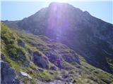
A beaten footpath from the parking lot leads into grassy slopes, where a well-preserved mule track follows, which ascends in zigzags to the saddle Vrata. A little below the saddle, the footpath branches off into the slope, through a short tunnel, onto the ridge and to the summit. On the summit there is a bigger cairn. The footpath, actually a level mule track, continues on the southwest slope right below the ridge towards Srednji vrh and in the direction of Krn, where it is not possible without harder climbing.
Along the route: sedlo Vrata (1938m),
Lopatnik (2012m), Skutnik (2074m), ostanki italijanskih vojaških položajev (2000m)
Photos:
 1
1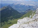 2
2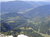 3
3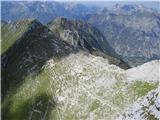 4
4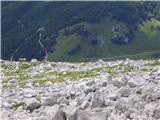 5
5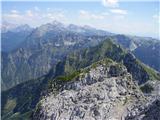 6
6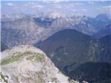 7
7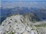 8
8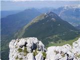 9
9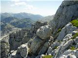 10
10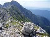 11
11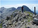 12
12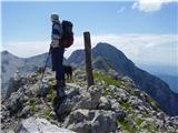 13
13
Discussion about the trip Planina Zapleč - Krnčica (unmarked mule track)
|
| mili3. 10. 2011 |
We did the tour on Sunday, the view from the summit is superb. The path is completely freshly marked, which is very helpful when transitioning from the mule track to the summit. The road to the mountain pasture is not in the best condition though.
|
|
|
|
| CarpeDiem2471. 01. 2015 |
If anyone wants to go to Krnčica tomorrow (2.1.) and maybe has no transport, let's meet at 7:30 at Petrol in Kobarid and hop in the blue off-road vehicle, then we'll drive together to Planina Zapleč.
|
|
|
|
| David M2. 01. 2015 |
I plan to go up tomorrow. What are the conditions on the path like - snow amount, is it trodden at all? Is the road to the planina passable for a regular car (Fiat Scudo van)?
|
|
|
|
| CarpeDiem24711. 08. 2015 |
Yesterday we visited Krnčica from Planina Zapleč and I have to say that the gravel road is in quite good condition, e.g. my R Clio didn't get stuck anywhere or encounter any problems. The path is suitable for everyone, as it's not particularly exposed and no major hazards are encountered anywhere on the entire path to Krnčica (I'm talking about the return on the same path to Zapleč).
Perhaps it would be worth updating the summit photo, as there is now a quite prominent cross on the top.
|
|
|
|
| darinka45. 05. 2017 |
Has anyone been to Krnčica this year? What's the road to Planina Zapleč like?
|
|
|
|
| palček plezalček6. 05. 2017 |
Darinka, a month ago I drove to the trough, which is indeed a bit above Drežniške Ravne, but I saw a car returning from the alpine pasture. I think they were foresters because I could hear sawing. It wasn't an off-road vehicle.
|
|
|
|
| darinka46. 05. 2017 |
Aha, probably doable. I asked because I planned to go up there today. But then I chose Krn. I've been to Krnčica only once and it was a nice tour. Thanks anyway.
|
|
|
|
| keti121. 06. 2017 |
Yesterday we did this tour (from Drežniške Ravne). The road isn't the best for lower vehicles. Above Planina Zapleč the path is exemplarily marked and very beautiful. Despite the great steepness of the slope to Vrata it is routed comfortably throughout and nowhere steep. What excited me most was the continuation from Vrata, where a wide and comfortable path continues, just occasionally narrower, nowhere truly exposed. The view from the top is wonderful. Further towards Krn there were still markings. Wondering if the difficulty increases further to Krn?
Definitely a nice tour, but quite demanding due to the large elevation difference.
|
|
|
|
| rozka22. 06. 2017 |
Hi @keti1... I hiked the path beyond Krnčica last year and it's marked all the way to the "notch" between Batognica and Krn. I really liked it, no dangers, wide enough and comfortable to walk, so... go for it boldly
|
|
|
|
| Enka22. 06. 2017 |
Interesting, but the path description says that to Krn "difficult climbing" is required 
|
|
|
|
| mirank22. 06. 2017 |
Of course, the describer meant the direct ascent to the summit from the notch between Krn and Srednji vrh, and even there it's not really panic, just know the right passages. The path crosses the scree slope to the left onto the path from the lake a few meters below the notch between Krn and Batognica...
|
|
|
|
| ljubitelj gora22. 06. 2017 |
The road to Planina Zapleč was very bad 2 weeks ago. I don't recommend it, leave the car at the end of the asphalt.
|
|
|
|
| keti122. 06. 2017 |
Rozka, thanks for the reply. I also read before that the continuation towards Krn is very demanding, so I was surprised that such a "climbing" path would be so nicely marked.
We'll try it next time
|
|
|
|
| rozka23. 06. 2017 |
@keti1... I checked the photos from that hike again, just in case, , too bad I can't upload them here... the path that branches left from the top of Srednji vrh under the wall, onto the scree and joins the marked one from K. lake below the notch, nice, easy, with wonderful views, where you can stray a bit off the path or stick to the marks... I think you'll enjoy it, but it's really good to have two cars, otherwise the return is looong
good luck...
|
|
|
|
| gor in dol19. 08. 2017 |
The road to pl. Zapleča was very bad 2 weeks ago. Please some newer info on the condition of this road? Thanks
|
|
|
|
| gor in dol19. 08. 2017 |
mountain lover: "The road to pl. Zapleč was very bad 2 weeks ago"... Please provide some newer info regarding the condition of this road? Thanks
|
|
|
|
| maks5716. 08. 2018 |
Please, can I have some information about the condition of the road to Planina Zapleč.
|
|
|
|
| julika16. 08. 2018 |
3 weeks ago very bad, not for low cars
|
|
|
|
| maks5717. 08. 2018 |
Thanks for the answer, Julika! I will definitely follow your advice, as I (unfortunately) have a low car.
|
|
|
|
| darinka427. 08. 2018 |
So where do you park the car then? In Drežniške Ravne? How much longer is the walk to the top of Krnčica then?
|
|
|
|
| mirank27. 08. 2018 |
At the trough above Ravne; the tour is extended by about an hour - all depending on the pace
|
|
|
|
| keti128. 08. 2018 |
Immediately after the trough there is a junction: right points to pl. Zapleč and Vrata, left to pl. Zaprikraj and Krasji vrh. I recommend the left variant, it is much more pleasant, almost the whole time in the shade, and from pl. Zaprikraj you then descend 5 min towards pl. Zapleč to the junction for Vrata.
|
|
|
|
| darinka430. 08. 2018 |
We were yesterday. We left the car at the trough, although the road seemed quite fine to us. And with ordinary low cars they were driving to the planina. We decided to go straight across the grass to the ridge. It didn't look so steep towards the summit as it was in reality. Even on all fours it was nicely passable. There was no such high grass. Then walking along the ridge all the way to the top of Krnčica.
|
|
|
|
| piamhrob5. 07. 2019 |
Very nice path. I recommend starting the path on the macadam road from the Drežniške ravne parking lot to Planina Zapleč, then on the well-marked path towards Lopatnik and further towards Krnčica. The path is easily passable.
|
|
|
|
| winni23. 06. 2020 |
It's a shame there's no trough near the summit itself, it could be one of the most beautiful military paths among us, especially with such views. 
|
|
|
|
| mirank23. 06. 2020 |
yeah and what else, asphalt to Zapleč and a bit more on the mulatiera
|
|
|
|
| winni4. 07. 2020 |
Especially, they could fix the road to Zapleč, because in some places it's really desperate.
|
|
|
|
| Jure1914. 09. 2020 |
Hi. So is the path marked afterwards? I'd gladly head to the summit next week, but unmarked paths don't attract me.. how are the markings then, is the path well marked or not? Thanks for the answers!
Best, Jure
|
|
|
|
| darinka414. 09. 2020 |
The path from Zapleč is visible. At least we had no problems. The road, however, is full of potholes.
|
|
|
|
| Enka19. 09. 2020 |
From Planina Zapleč the path is visible, basically marked but not richly. However, there is no chance to get lost. From the junction to the right (towards the tunnel) onwards the path is excellently newly marked all the way to the top.
|
|
|
|
| 12a3bc15. 06. 2021 11:13:56 |
On the map there is a drawn path to the middle peak (below Krn) but I can't find instructions to it. I'm interested if anyone has hiked this path and if there is a path or if it's passable off-trail between the peaks middle peak, Krnčica, Skutnik, Lopatnik, Oblo brdo, Vrh Ruš, Vršič and Kal?
Thanks for answers.
|
|
|
|
| mirank15. 06. 2021 11:53:10 |
These are former positions of the first combat line of the Italian army and as such can be passable. The path-clearly visible under the north face of Krn-leads to the Lepena-Krn trail right below the notch in the main ridge. Everything is clearly visible on the terrain and you can't get lost.
|
|
|
|
| darinka415. 06. 2021 11:58:04 |
Yes, Srednji vrh is a bit further from Krnčica, if you go from Lopatnik. A couple of years ago we hiked from Planina Zapleč to Lopatnik Vrata, Krnčica Srednji vrh Krn. Also from Planina Zaprikraj you can find a path to Vrh Ruš Vršič and Oblo brdo. It is possible to go along the ridge. At least as I remember a few years ago. Now I don't know how it is. But if you plan to go from Krn to Skutnik and Griva I advise you to take someone with you who has been there before. There are some bushes along the paths. In some places there isn't even a path anymore I think. And most importantly. Never in fog. And watch out for snakes. I remember on Kal there were two adders not far from each other. Black and patterned. They have peace there from us.
|
|
|
|
| 12a3bc17. 06. 2021 13:38:06 |
If anyone is interested in the path along the far right mule track, which is supposed to lead to the middle summit. It is drawn on the map on hribi.net as well as on Google maps.
Yesterday we set off along the mentioned path which unfortunately time has overtaken due to winters and lack of maintenance. Initially the path on the meadow and through the little forest is well preserved. Then we reach a snowfield behind which the path is occasionally visible but overgrown with tall grass, low bushes. The passability and visibility of the path is further hindered by tall bushes and small trees that have overgrown it. With the help of Google maps and location enabled, we managed to reach the top of the bends where the path should continue transversely to the left. But there the path ends. In principle we could try to cross the wall but due to unsuitable equipment, some snowfields, risk of slipping and falling rocks we preferred to return to the valley. The path itself would be pure guesswork.
It's a pity the path wasn't preserved as it offers really fantastic views.
|
|
|
|
| Tf5621. 06. 2021 18:08:08 |
The trail is well preserved and visible and also marked. But along the ridge at certain points there is still some snow so winter gear is not superfluous.
|
|
|
|
| lepenatka18. 09. 2021 15:56:04 |
This beauty has been tempting me for some time too.
How much time is needed for the path from Krnčica over Srednji Vrh to Škrbina (normal walking)?
|
|
|
|
| j.19. 09. 2021 15:37:51 |
Hello, Lepenatka! About an hour and a half of normal walking. Depends on how tired you are from the previous hike. The path that branches off towards the summit of Krnčica crosses that summit and later rejoins the lower path. I didn't notice it and therefore went back about 150 m on the same path to the lower one and thus lost 5 to 10 minutes.
Good luck!
|
|
|
|
| lepenatka19. 09. 2021 17:44:05 |
Super, thanks.
I hope I manage to reach these very remote ends this year too.
|
|
|
|
| Primozz_9415. 06. 2022 20:13:52 |
Hello!
Has anyone done the ridge between Lopatnik Krnčica and the middle summit this year, interested in remaining snow in the gullies. Best, Primož
|
|
|
|
| taja322. 06. 2022 16:52:58 |
No snow between Lopatnik and Krnčica - checked on 20.6., I think there's no more snow further along the ridge to Srednji vrh either.
|
|
|
|
| Aleksanh28. 06. 2024 22:23:18 |
Hello, I'm interested in the path to Krničica, is it snow-free and how is it marked.
|
|
|
|
| tadej123423. 09. 2024 19:37:18 |
the road to the pasture was quite okay in July (for me). Actually the macadam is very nice, some places on one bend are a bit dug up but you can go around, because it's quite a wide bend. the only problem are large and in a few places also deeper ditches for water drainage, but if you go smartly through with the car (turn so that the tires are diagonally on the ridge) it's no problem. my car has 13-18 cm ground clearance
|
|
|
|
| Evjuna24. 09. 2024 17:23:06 |
On 4 September the road (for me) was very bad to desperate. Diagonal up or down, I drove mostly in 1st gear and even then it rattled a few times down there somewhere.
|
|
|
|
| Darxta25. 09. 2024 11:06:13 |
On Sunday (22.9.) it went without problems with an urban SUV with 21 cm ground clearance and only front-wheel drive. As tadej wrote, there are a couple of ditches where you need to go slower. My companion and I figured that with his Kia Ceed it probably wouldn't go without scraping the bottom.
But that's why the mulatjera is so much nicer to walk. There aren't many peaks where access to the starting point is more demanding than the hiking path to the summit
|
|
|
To post a comment you must log in:
If you do not yet have a username, you must first
register.