Podkraj - Vojkova koča na Nanosu
Starting point: Podkraj (798 m)
| Latitude/Longitude: | 45,86170°N 14,05960°E |
| |
Walking time: 4 h 30 min
Difficulty: easy marked way
Elevation gain: 442 m
Elevation difference along the route: 600 m
Map: Nanos 1:50.000
Recommended equipment (summer):
Recommended equipment (winter): crampons
Views: 7.764
 | 1 person like this post |
Access to starting point:
A) From the highway Ljubljana–Koper, we take the exit Logatec and continue to Logatec. From the roundabout, where we reach the old road, we continue in the direction of Idrija and Tolmin. We drive on the main road towards Idrija, and at the end of the settlement of Kalce we turn left towards Podkraj and Col (this crossroads is located only a few tens of meters beyond the turn-off for Planina and Postojna). From Kalce onwards the road becomes quite winding, and we follow it all the way to Podkraj. Here we turn left towards the center of the village and after a short descent sharply left in the direction of Nanos. When the village ends, we drive into the forest and park at an appropriate place by the road.
B) From the highway Nova Gorica–Razdrto, we take the exit Ajdovščina, then we follow the road towards Col and Idrija. At the beginning of Col we turn right towards Podkraj and Logatec and continue to Podkraj. Here we turn right towards the center of the village and drive past the church to the crossroads, where we continue straight in the direction of Nanos. When the village ends, we drive into the forest and park at an appropriate place by the road.
Route description:
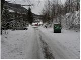
From the starting point we continue along a macadam road to which the marked path from the center of Podkraj already joins from the right after a few minutes. We continue along the road which, past a smaller sign in a gentle descent, brings us to the first crossroads. Here we continue straight in the direction of Nanos (right Bela and Sanabor). From the crossroads the road leads into a dense forest and transitions from the slopes onto the plateau terrain of Nanos. In the forest we soon arrive at the second crossroads, where we continue sharply right (left Bukovje). The road then continues with some ascents and descents all the way to the crossroads below the 905-metre-high peak of Soline.
Here we continue straight in the direction of Abram (left Trška ravan, right Sanabor) and follow the macadam road which gradually transitions onto the predominantly western slopes. When the road rises slightly, it brings us to a smaller hamlet Blažon, from where a view opens towards the sea and, in good visibility, also to the Dolomites. We bypass the hamlet on the right side, after which the road gradually begins to descend into the forest, through which we descend to a somewhat larger crossroads. Here we continue left in the direction of Abram (right Vipava) and follow the slightly ascending road, which leads us through increasingly sparse forest to Furlanovo zavetišče pri Abramu. We reach it after a good twenty minutes of walking.
We bypass Furlanovo zavetišče pri Abramu on the left side and continue along the road, along which after a few tens of steps we arrive at the hunting lodge, in front of which there is a large parking lot.
From the parking lot we continue along the road in the direction of Vojkova koča and Podnanos. The gentle road quickly brings us to a smaller hamlet, where we continue along the upper left road. The road leads us along the edge of the forest, from where a beautiful view opens to the Dolomites. A little further on the road enters a dense forest and brings us to the next crossroads, where we continue straight. We walk through the forest for a few more minutes, then the road brings us to increasingly panoramic slopes. Here we notice the signs for Vojkova koča, which direct us left onto a marked but in places somewhat overgrown footpath. After the initial ascent the path quickly levels out and brings us onto the plateau terrain. A little further we cross a short strip of scrub, then the path continues for some time across extensive and partly overgrown karst meadows. A short ascent follows and the path brings us to the next road, which we follow right downhill. After a short descent we leave the road again and continue the ascent left onto a marked cart track, along which we first ascend relatively steeply, then gently. Further on we ascend along the edge of the indistinct valley Ječmenovec, higher up the path enters the forest, through which it ascends to the bare saddle northwest of Laniški vrh (1236 m).
From the saddle a descent follows to the nearby road leading to Vojkova koča, but we only cross it and continue on the marked mountain path. The path soon turns slightly left and higher up returns to the aforementioned road. The moderately steep path, from which occasional views open up, then continues alternately through the forest and partly along the macadam road. We follow this path all the way to Vojkova koča na Nanosu.
Podkraj - Abram 2:30, Abram - Vojkova koča 2:00.

Photos:
 1
1 2
2 3
3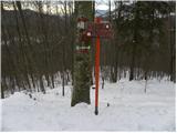 4
4 5
5 6
6 7
7 8
8 9
9 10
10 11
11 12
12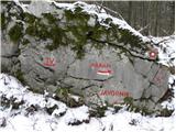 13
13 14
14 15
15 16
16 17
17 18
18 19
19 20
20 21
21 22
22 23
23 24
24 25
25 26
26 27
27 28
28 29
29 30
30 31
31 32
32 33
33 34
34 35
35 36
36 37
37 38
38 39
39 40
40 41
41 42
42 43
43 44
44 45
45 46
46 47
47 48
48 49
49 50
50 51
51 52
52 53
53 54
54 55
55 56
56 57
57 58
58 59
59 60
60 61
61 62
62 63
63 64
64 65
65 66
66 67
67 68
68 69
69 70
70 71
71 72
72 73
73 74
74
Discussion about the trip Podkraj - Vojkova koča na Nanosu
|
| sportnick2. 05. 2012 |
The path from Podkraj to Furlanovo zavetišče pri Abramu is terrible. It runs along a macadam road the whole time, which drags on for a good 2 hours. Unfortunately, the transverzala runs exactly along this path. Much nicer access to Abram is from Vipava.
|
|
|
|
| sportnick2. 05. 2012 |
The path from Furlanovo zavetišče pri Abramu to Vojkova koča na Nanosu is one of the nicer ones in this area. Wonderful views, nicely routed path, and at the end excellent food awaits you in Vojkova koča.
|
|
|
To post a comment you must log in:
If you do not yet have a username, you must first
register.