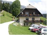
Podolševa (Rogar) - Potočka zijalka
Starting point: Podolševa (Rogar) (1240 m)
| Latitude/Longitude: | 46,43550°N 14,65950°E |
| |
Walking time: 1 h 5 min
Difficulty: easy marked way
Elevation gain: 420 m
Elevation difference along the route: 420 m
Map: Kamniške in Savinjske Alpe 1:50.000
Recommended equipment (summer):
Recommended equipment (winter):
Views: 44.119
 | 2 people like this post |
Access to starting point:
A) We drive to Luče (to here from Mozirje or from Kamnik over the mountain pass Volovljek (Kranjski Rak)), and then we continue driving towards Logarska dolina. In the village Solčava we leave the main road towards Logarska dolina and continue driving right in the direction of Podolševa, mountain pass Spodnje Sleme and Črna na Koroškem. Further on, the road loses its asphalt covering, and after a few kilometers at the crossroads in Podolševa we turn left in the direction of the panoramic road (right mountain pass Spodnje Sleme and Črna na Koroškem). Further, we drive towards the church of the Holy Spirit, and we park a few 100 m before the church at an appropriate place by the road near the farm Rogar.
B) We drive to Črna na Koroškem (to here from Ravne na Koroškem or from Šoštanj through the mountain pass Spodnje Sleme), and then we continue driving towards Luče. Initially still asphalt road, higher it becomes macadam and brings us to the crossroads of several roads on the mountain pass Spodnje Sleme. From the mountain pass we continue towards Solčava, then already somewhat lower we turn right in the direction of the panoramic road (by the left road we arrive in Solčava). Further, we drive towards the church of the Holy Spirit, and we park a few 100 m before the church at an appropriate place by the road near the farm Rogar.
Route description:
From the starting point we first walk to the tourist farm Rogar, from there we continue left on the cart track, which starts to ascend through the forest. A little higher a cart track also joins us from the left, which comes from the church of the Holy Spirit, and we continue right on the marked path which leads towards Olševa. The cart track then changes into a footpath which quickly brings us to the national border. Further, we ascend for some time along the national border, and then we arrive at a marked junction, where we continue right in the direction of Potočka zijalka (left Remšenik / Remschenig).
From the junction follows approximately 10 minutes of steep ascent and we are already at the karst cave named Potočka zijalka.
Photos:
 1
1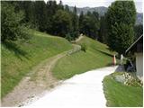 2
2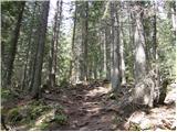 3
3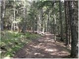 4
4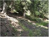 5
5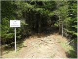 6
6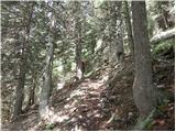 7
7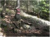 8
8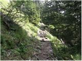 9
9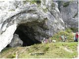 10
10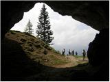 11
11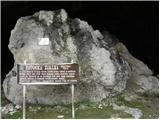 12
12
Discussion about the trip Podolševa (Rogar) - Potočka zijalka
|
| JTrogar8. 02. 2010 |
The road from Solčava to Rogar is normally drivable, also ideal for sledding. I parked below Rogar, then on skis all the way to Potočka zijalka. The trail is also nicely trodden. In Zijalka it's a fairytale. Further towards Govec there is no trail, and conditions are not safe enough yet. I skied down the gully below Zijalka. I had to take off my skis for a couple of meters just below and poke a bit with the ice axe, because there isn't enough consolidated snow to fill that drop. Further on it's ok again.
Best regards from below the beautiful Mozirska planina, Janez.
|
|
|
|
| Mr.Dani15. 03. 2010 |
Yesterday 14.3. (PI day) my wife and I went to see the ice stalactites in Zijalka. The road from Solčava to Rogar nicely plowed, same further to Logarska dolina. Parked below Rogar, where there is a plowed spot. The path to Zijalka was not yet trodden in the morning. Quite a lot of new snow. Crossed avalanches at a couple of places. In the cave a fairy-tale view of the "forest" of ice stalactites. On the descent we met a few more hikers. Unforgettable morning trip.
LP
|
|
|
|
| Mr.Dani15. 03. 2010 |
Some more photos of the ice fairy tale:
|
|
|
|
| Mr.Dani16. 03. 2010 |
Tadej, thanks for the explanation. I'm even "greener" on the forum. I see that Janez has posted wonderful photos. I just wanted to attach a couple of pictures when the path was still "innocent"
Best, Dani
|
|
|
|
| EUGEN16. 03. 2010 |
It's nice to visit the windows on the Austrian side as well.
|
|
|
|
| Jure S1. 08. 2010 |
I also walked this trail today, but on a slightly different variant. I then returned on the one described.
I parked at the guesthouse, whose name I forgot, and immediately right up the slope. Then for a while on the forest road, then onto the forest path, which for quite some time runs exactly along the border. The path then joins the usual one described above.
Nice trail, very well maintained. I also liked the cave
I will return in winter time to see the ice fairytale in the cave
|
|
|
|
| miskec8. 06. 2015 |
Today I was cycling on the Solčava panoramic road. At the church of St. Duh I left the bike and right into the forest past the tourist farm. After a few minutes I reached a gravel forest path (still markings) and continued along it hoping I was on the right path. After about a kilometer, a narrower path continues into the forest, but the gravel turns sharply right. Since the markings were not visible or absent, I continued on the gravel. After ten minutes I reached a no-entry sign and barrier, shortly after crossing the marked bear path. After about 30 minutes of walking I reached a wall and since I didn't know the further path, I didn't continue. Can someone who knows the path explain where I went wrong? Thanks
|
|
|
|
| pixelator197618. 08. 2025 11:14:17 |
The trail is very poorly marked at a key point. Namely, about 20 minutes above Rogar homestead, you need to turn from the gravel road (which is wider and looks like the main correct path) onto a narrower forest trail. It is marked with a "Medvedova pot" sign, but unfortunately nowhere does it say that "Medvedova pot" is the one leading to Potočka zijalka. The marks are also deficient there and it's really easy to make a mistake. If you continue on this wrong (but very wide) gravel road, it simply ends in the forest after about a kilometer. We were there with a group of 10 people, including 4 children, and we got lost that way. Then follows "bushwhacking" through the forest and searching for the right path with GPS on our phone. We eventually found the trail, but only after someone in our group fell in the forest and got badly injured with bleeding. This spoiled our trip and only half of our group made it to Potočka zijalka. Really a shame that the trail is so poorly marked. Please, fix the markings so they are clear also for those who are on this path for the first time!
|
|
|
|
| pixelator197618. 08. 2025 11:16:25 |
@miskec See my post, the same happened to you in 2015 as to us 10 years later!!
|
|
|
To post a comment you must log in:
If you do not yet have a username, you must first
register.