Povlje - Krničarjeva koča na planini Javornik
Starting point: Povlje (710 m)
| Latitude/Longitude: | 46,32960°N 14,37680°E |
| |
Walking time: 2 h
Difficulty: easy marked way
Elevation gain: 680 m
Elevation difference along the route: 680 m
Map: Karavanke - osrednji del 1:50.000
Recommended equipment (summer):
Recommended equipment (winter):
Views: 14.378
 | 1 person like this post |
Access to starting point:
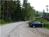
a) From the Ljubljana-Jesenice motorway take the Brnik exit, then when reaching the Mengeš-Kranj road continue left towards Kranj. Drive along the main road towards Kranj to the first roundabout, from where continue on the first right exit towards Šenčur. Continue through Šenčur on the main road, then when reaching the Kranj-Zgornje Jezersko road continue right towards Jezersko. When arriving in Preddvor leave the main road and continue left towards the centre of the mentioned place, from there follow the signs to the Bašelj settlement. Somewhat after the Bašelj settlement the road descends to the Milka stream and crosses it over a bridge. Here a road first branches right to the village Babni Vrt, a good 100 m further also to the village Povlje. Continue on the ascending road towards Povlje, park on a small parking lot above the village. At the starting point there is a small intersection, several hiking direction signs and a large information board of the Trstenik walking-educational trail "path under Storžič".
b) From the Jesenice-Ljubljana motorway take the Kranj west exit, then continue driving towards Golnik. When arriving in Tenetiše leave the main road towards Golnik and continue right towards Trstenik. Approximately 1 km after the Trstenik settlement arrive at a small intersection, where continue left towards the village Povlje. Continue on the ascending road towards Povlje, park on a small parking lot above the village. At the starting point there is a small intersection, several hiking direction signs and a large information board of the Trstenik walking-educational trail "path under Storžič".
Route description:
From the parking lot continue on the left road, from it go immediately slightly right onto the footpath towards Storžič, Kališče, Planina Javornik and Dolenčeva path to Velika Poljana. The path ahead first gently, then moderately ascends through the forest, soon leading us to a forest road. Continue the ascent on the occasionally steeper forest road, where due to numerous junctions carefully follow the markers, leave the forest road several times as the markers occasionally lead us also along a trail. For some time we still walk on the trail and alternately on the forest road, on the slope heavily damaged by weather disasters, so there are several large clearings along the path.
Higher, at the marked junction continue towards Storžič, Kališče and Planina Javornik (the forest road continues to Velika Poljana). From the junction the path becomes quite steep, as the already steep old path became impassable due to numerous fallen trees, then the path turns right and temporarily flattens. A few-minute traverse to the right follows, then we step out of the forest and arrive at the south-western gully of Storžič, along which we ascend to the nearby marked junction.
From the junction continue left (straight is the path to Storžič which bypasses Krničarjeva koča and is about one minute shorter) and ascend transversely across the scenic slope to Krničarjeva koča na Planini Javornik.
Starting point - first refreshment point 0:45, first refreshment point - junction below Planina Javornik 1:10, junction below Planina Javornik - Planina Javornik 0:05.
Description and photos refer to the condition in 2016 (June).

Along the route: Prva okrepčevalnica (998m), Razpotje pod Planino Javornik (1355m)
Photos:
 1
1 2
2 3
3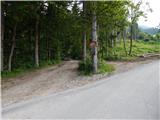 4
4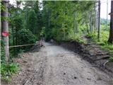 5
5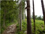 6
6 7
7 8
8 9
9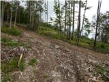 10
10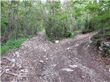 11
11 12
12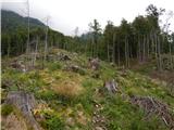 13
13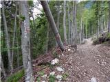 14
14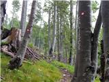 15
15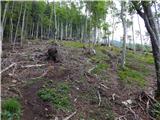 16
16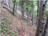 17
17 18
18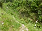 19
19 20
20 21
21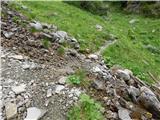 22
22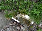 23
23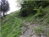 24
24 25
25 26
26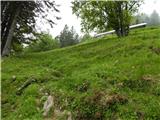 27
27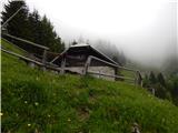 28
28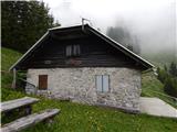 29
29
Discussion about the trip Povlje - Krničarjeva koča na planini Javornik
|
| pelican4. 11. 2010 |
Is the hut open?
What about Krničarjeva hut?
|
|
|
|
| pelican4. 11. 2010 |
or rather the hut on Velika or Mali Poljana?
|
|
|
|
| hribolazecales15. 02. 2020 |
Last summer Krničarjeva koča was closed and looks neglected.
|
|
|
|
| Daaam15. 02. 2020 |
On Velika Poljana it's supposedly open every weekend. But not quite certain. On Mala poljana it's open when Joža is grazing cows 
|
|
|
|
| letenar8. 08. 2022 09:28:31 |
At the Povlje parking lot, the sign to Planina Javornik is currently down. At the beginning of the path into the forest (which goes left from the parking lot), you need to go right immediately on an overgrown path. The path goes in the upper part along the road and in the sun and is not the nicest. If you're lucky, during the grazing season there might be a caretaker at the hut in the morning.
|
|
|
|
| di19. 08. 2025 16:12:53 |
"We haven't walked a more annoying path in a long time," says the companion who goes on tours several times a week and who a few years ago summited 150 different Slovenian 2000ers in a season.
Returning via Krničarjeva koča, due to the confusion of the marked path (where does it actually go?), one group prefers to detour via V. Poljana (and reaches the goal sooner) than the other group which descends down there (for the loop), of course on unmarked terrain since the marked path fades (wasting time and energy searching).
On the higher path toward Storžič, two chamois were seen.
|
|
|
To post a comment you must log in:
If you do not yet have a username, you must first
register.