Povlje - Velika Poljana (Dolenčeva pot)
Starting point: Povlje (710 m)
| Latitude/Longitude: | 46,32960°N 14,37680°E |
| |
Route name: Dolenčeva pot
Walking time: 1 h 45 min
Difficulty: easy marked way
Elevation gain: 675 m
Elevation difference along the route: 700 m
Map: Karavanke - osrednji del 1:50.000
Recommended equipment (summer):
Recommended equipment (winter):
Views: 27.652
 | 3 people like this post |
Access to starting point:
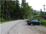
a) From the Ljubljana - Jesenice motorway take the Brnik exit, and when reaching the Mengeš - Kranj road, continue left towards Kranj. Drive along the main road towards Kranj to the first roundabout, from where continue on the first right exit towards Šenčur. Through Šenčur continue on the main road, then, upon reaching the Kranj - Zgornje Jezersko road, continue right towards Jezersko. When arriving in Preddvor leave the main road and continue driving left towards the centre of the mentioned place, from there follow the signs to the Bašelj settlement. Somewhat after the Bašelj settlement the road descends to the Milka stream and crosses it over a bridge. Here to the right first branches the road to the villages Babni, Vrt, some 100 m further also to the village Povlje. Continue on the ascending road towards Povlje, park on the small parking lot above the village. At the starting point there is a small intersection, several mountaineering direction signs and a larger information board of the Trstenik walking-educational trail "path under Storžič".
b) From the Jesenice - Ljubljana motorway take the Kranj west exit, then continue driving towards Golnik. When arriving in Tenetiše leave the main road towards Golnik and continue driving right towards Trstenik. Approximately 1 km after the Trstenik settlement arrive at a small intersection, where continue left towards the village Povlje. Continue on the ascending road towards Povlje, park on the small parking lot above the village. At the starting point there is a small intersection, several mountaineering direction signs and a larger information board of the Trstenik walking-educational trail "path under Storžič".
Route description:
From the parking lot continue on the left road, from it go immediately slightly right onto the footpath towards Storžič, Kališče, Planina Javornik and Dolenčeva pot to Velika Poljana. The path ahead first gently, then moderately ascends through the forest, soon bringing us to a track. Continue the ascent on the occasionally steeper track, where due to numerous junctions carefully follow the blazes, leave the track several times as the blazes occasionally lead us also on a trail. For some time we still walk on the trail and alternately on the track, on the slope severely damaged by weather disasters, so there are several larger clearings along the path.
Higher, at the marked junction, at the first refreshment point continue left towards Dolenčeva pot (right Planina Javornik, Storžič and Kališče).
Follows a traverse ascent to the left, in a few minutes arrive at a pleasant arranged spring, behind it the path gradually more steeply ascends and higher joins the track, which we follow to the left, along it quickly arrive at the Petelinc ridge and junction, where we also join another path from the starting point in Povlje and a path from the starting point in Zalog.
Continue right upwards on the initially gentle track, which leads us past the "second refreshment point". After the refreshment point the track continues straight ahead, we from the track continue slightly right onto a parallel trail that ascends somewhat above the track. Higher cross the track and some kind of pasture fence, then gradually also pass from the forest to grassy slopes. A little further step again onto the track, and ahead we already see the Koča na Veliki Poljani, to which only a short, increasingly panoramic ascent separates us.
Starting point - first refreshment point 0:45, first refreshment point - second refreshment point 0:30, second refreshment point - Koča na Veliki Poljani 0:30.

Along the route: Prva okrepčevalnica (998m), Druga okrepčevalnica (1198m)
Photos:
 1
1 2
2 3
3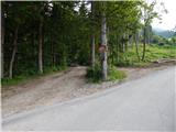 4
4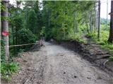 5
5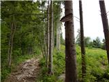 6
6 7
7 8
8 9
9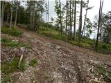 10
10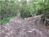 11
11 12
12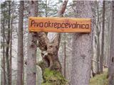 13
13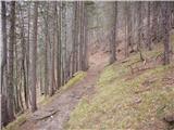 14
14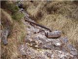 15
15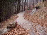 16
16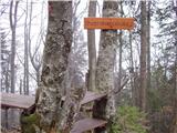 17
17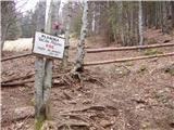 18
18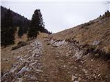 19
19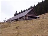 20
20
Discussion about the trip Povlje - Velika Poljana (Dolenčeva pot)
|
| milosj4. 03. 2007 |
Nice hike! If the trail were longer and better marked, it would be kitschy. The trail is really nicely maintained, and at the end rewarded with the friendliness of the hut keeper.
|
|
|
|
| vladopohodnik7. 08. 2007 |
As an occasional hiker, it wasn't hard to find the hut that still has an unspoiled mountain soul and naturally friendly caretakers. Above all, however, the wonderful sour milk and buckwheat bread, because of which it won't be hard for me to return to this mountainous area of beautiful Slovenia.
|
|
|
|
| velkavrh7. 08. 2008 |
Easy hiking trip, really suitable for building fitness for more demanding tours. Went along the so-called Dolenčeva path, which is nicely maintained by PD Kokrica, there's even a small spring equipped in the middle, even with a cup for drinking - very original. Unfortunately, the hut seems to be open only on weekends, so you have to go to Kališče or Kriška for tea or some 0.5l, which are about equally distant from here - two hours. On Mala Poljana, the shepherd can also serve something. It's only a good ten minutes away from here and he'll even show you his latest creations. A well-known Kranj painter pastures there.
|
|
|
|
| maja_dercar4. 10. 2009 |
At the parking lot I followed the sign VELIKA POLJANA - I don't recommend it if you don't like adventure and tireless uphill walking through the forest and rocky section. I arrived at Mala Poljana - closed - and then to Velika Poljana - praise to the friendly caretaker, he really tries with service and pleasant chat. Autumn is also a recommended time for Storžič!
|
|
|
|
| Ajda_Zitnik26. 12. 2011 |
Today I walked the path, which is only a bit slippery on the meadow under the hut (trodden snow), otherwise still dry.
I have to join the opinion that the caretaker is friendly and the food tasty.
|
|
|
|
| Kokta15. 04. 2013 |
Bear spotted in the forests around Velika Poljana. Caution is not superfluous.
|
|
|
|
| bozon27. 05. 2013 |
Nice outing. Really suitable for building fitness or a nice family trip.
|
|
|
|
| enanejka20621. 12. 2014 |
Today I climbed to Velika Poljana in the sun. Since the locals told me that Dolenčeva pot is not completely cleared yet, I prefer to go past the reservoir and sand pit - also marked. Super path. At the sign for V. Poljana you just go a bit further on the cart track with the car, lots of space to park. Otherwise the marks guide you already in the car.
Up there peace and quiet, hut open all weekends - talked to the new caretaker. Except if heavy rain or snow drifts.
Good goulash and flancati. I'll come again.
|
|
|
|
| karlos10125. 10. 2015 |
Where to go for a weekend trip? To Velika Poljana..!! Sunday 18.10.2015 nice day in good company with sun on the top .. The path itself climbs nicely and steadily, but it's definitely worth the effort as excellent food awaits at the end and a very friendly hostess and a wonderful hut with exceptionally decorated details... I can hardly wait for full snow as I'm sure to go ski touring... 
|
|
|
|
| jermi25. 02. 2019 |
Nice spring ascent to the Velika Poljana highland.
The smiling caretaker awaits me there. Whatever she put on the table was good. First košutnik to get the blood flowing through the veins, then ričet and gibanica from that old "Šporget". Yum. Then such a lawn that even Krvavec hides. And Bar coffee.
At this location, what I like most of all is the peace; paradise for those who need to stop time and for dog lovers.
Nice!
|
|
|
|
| Guinevere18. 11. 2023 16:27:21 |
First time visiting the hut, went up a fairly steep path, well marked, very pleasant sunny side in autumn time.
Hut owner Jerneja very friendly, cooks excellently, rabbit stew with polenta and cracklings, dessert also excellent. Got žganje odrivnik for the way home. Worth visiting!
Dogs welcome!
|
|
|
To post a comment you must log in:
If you do not yet have a username, you must first
register.