Pred Belo - Ojstrica (čez Skok in Šraj pesek)
Starting point: Pred Belo (571 m)
| Latitude/Longitude: | 46,31880°N 14,60050°E |
| |
Route name: čez Skok in Šraj pesek
Walking time: 6 h
Difficulty: very difficult unmarked way, difficult marked way
Elevation gain: 1779 m
Elevation difference along the route: 1779 m
Map: Grintovci 1: 25.000
Recommended equipment (summer): helmet
Recommended equipment (winter): helmet, ice axe, crampons
Views: 11.812
 | 6 people like this post |
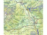
Access to starting point:
From Kamnik or Stahovica we drive into the valley of Kamniška Bistrica, approx. 2 km ahead from the parking lot by the bottom station of the gondola for Velika planina we drive to a bridge over the stream Kamniška Bela and approx. 100 m ahead on the right side of the road in the forest we turn onto a smaller parking lot, where we notice mountaineering markers and the beginning of the marked path to Presedljaj, Konj and Korošica.
It is also possible before the bridge to turn onto the forest road and after about 100 m park above the stream, but this path is often muddy, and further you have to cross the stream, which because of higher water levels sometimes is not possible.
Route description:
From the parking lot, we continue first on a marked path into the forest, which soon joins a wide cart track and runs more or less along the bed of Kamniška Bela, which at first still has water, further on but has no water on the surface. After approx. half an hour of comfortable walking we arrive at a marked junction, where we turn left onto the unmarked path to Slap Orglice and the hunting path over Skok and Šraj pesek, right or straight leads the marked path to Presedljaj, Konj and Korošica.
Further, the cart track slowly narrows into a comfortable path that runs right along the usually dry bed of Kamniška Bela and in good 10 min brings us to the lower pool of Slap Orglice. Before it we turn right upwards onto a less trodden path that runs along another smaller dry bed of a torrent and after about 200 m we cross it to the left and turn into a steeper forest slope. Usually at this spot there are already cairns, as this approach is also the closest for many climbers under Vežica from the Kamnik side.
At the beginning quite steep and narrow, the path soon flattens and turns left and runs for some time parallel above the bed of the torrent that also brings water for the aforementioned waterfall. The path is further well followable, slightly ascends and runs over grass and sparse forest, a little to the right, a little to the left side of the bed and we follow it all the way to the end, when we come to large rocks and to the head of the valley. There we cross the bed to the right and head again into a steeper forest slope, which then in zigzags in good 15 min brings us under Skok, which has three smaller consecutive stepped chimneys (climbing grade good II, perhaps II to III). In summer and when there is drought the rock is usually dry, wet however causes additional inconveniences when climbing, but with some experience and sense for climbing you will manage it; for descent however it is recommended to use a rope (30 m suffices) and abseil, as for this purpose at two key spots there are driven pitons with rings.
When we have climbed Skok, above it we turn left again onto a well visible path, which now stands even steeper upwards, first among grasses, then over the last remnant of forest. On this section there is also some small loose stones on the path and since we make zigzags, it is necessary to be careful not to dislodge them onto eventual followers on the ascent.
When we come out of the forest, in front of us and then on the right we see mighty walls of Vršakov and Vežice and the scree of Šraj peska. Going up we walk more to the right and closer to the walls, at the end of the scree - opposite a larger rock cavity, we climb over a rock step, then also over a belt of dwarf pines. Soon after that a nice view opens onto Petkove njive below us and onto the entire Ojstrica from the south side. Petkove njive at this elevation are really huge, flat and green meadow, from the left the path descends onto them from Srebrnega sedla (and from Koča na Kamniškem sedlu), on the right we can admire compact walls of Lučkega Dedca. The path from Petkovih njiv to Kocbekov dom na Korošici is otherwise short, but from this side also not yet marked and if you tackle it on the principle: the shortest is the closest, you will again have to struggle with high dwarf pines.
From the once nicely arranged Dom na Korošici (burned in 2017), to Ojstrica it is nicest to do a circular tour, up the eastern (right) ridge and back along the western or southern to the hut, from the hut onwards everything is marked and signposted.
The described path from the valley upwards is suitable also in summer, as you have the larger part of the forenoon in shade under Vršaki and Vežica and pleasant coolness, in the afternoon plenty of sun returns to you on the descent, but the path downwards is still less strenuous.
Walking length: approx. 4 hours to Korošica and another 1.5 to 2 hours to the summit.

Photos:
 1
1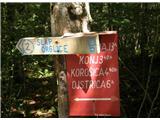 2
2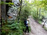 3
3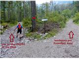 4
4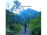 5
5 6
6 7
7 8
8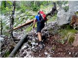 9
9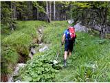 10
10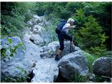 11
11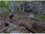 12
12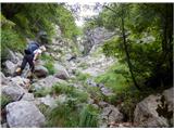 13
13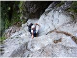 14
14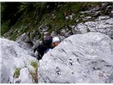 15
15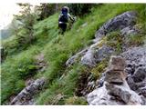 16
16 17
17 18
18 19
19 20
20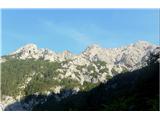 21
21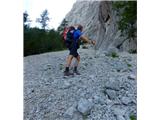 22
22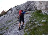 23
23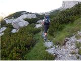 24
24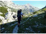 25
25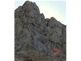 26
26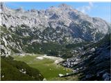 27
27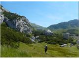 28
28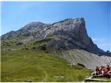 29
29 30
30 31
31 32
32 33
33 34
34 35
35 36
36 37
37
Discussion about the trip Pred Belo - Ojstrica (čez Skok in Šraj pesek)
|
| ljubitelj gora11. 07. 2015 |
Also missing under difficulty: Very demanding pathless terrain at least where you have to climb, pictures 14-15 before these jumps and above jumps there is really a path. Picture 13 really is a path to the left but it ends at the edge of a precipice. Probably the path to the left is there because most don't find an easier passage to Korošica and return to the valley. Return via Korošica, Presedljaj and to the valley.
|
|
|
|
| franca12. 07. 2015 |
Picture 13: the path ends. If we follow it to the end, we climb a couple of meters straight up (right) (easy) and we're in steep forest. This is a bypass for the jump when the rock is wet. This forest ascent is not really easy either, the slope is considerable, but no climbing. Just at the end it's a bit harder to find the passage through the scrub.
|
|
|
|
| klacki12. 07. 2015 |
My girlfriend and I did this path recently, as that part was still unexplored for us and we went, and before Skok we also went to Kamniška jama (nice path, but steep as hell, you really bite into that slope), then down and up again towards Šraj pesek, we didn't go straight out over the jumps but took the path left and then climbed a bit (those not used to a little traversing shouldn't go here without a rope, so nothing gets tangled  !!!), then full speed along that entire ridge and we reached Šraj pesek, but to the left side scree then straight to Korošica for a schnapps and beer , then over Presedljaj back to Kamniško Great for hiking, peaceful, you don't meet a soul... really nice end to Kamniško-Savinjskih. !!!), then full speed along that entire ridge and we reached Šraj pesek, but to the left side scree then straight to Korošica for a schnapps and beer , then over Presedljaj back to Kamniško Great for hiking, peaceful, you don't meet a soul... really nice end to Kamniško-Savinjskih.
|
|
|
|
| gams113. 07. 2015 |
As far as I have seen, you can avoid this Skok by going via Najnar štant, but how demanding and how orientationally problematic that is compared to the described route, which is very well and logically described.
|
|
|
|
| garmont13. 07. 2015 |
The hunting trail through Najnar štant is more orientationally demanding than the path described above. On one shorter section you scramble (1st degree), on larger sections it is exposed. I could say exactly as someone else on this forum already did: Whoever is not grown up to Skok, won't feel best on this trail either.
|
|
|
|
| franca14. 07. 2015 |
In the comments (on picture 13 etc.) we are not talking about the path through Najnar štant, but about the (non-)path that goes through the forest left of Skok. There where we reach the gully with the jump, we go a bit further left on the path, scramble a few meters on rocks to the right and search for the best passages through the forest. In wet safer than through Skok, also a bit easier.
|
|
|
|
| garmont14. 07. 2015 |
@Gams1 asks about the path through Najnar štant and not about the bypass of Skok.
|
|
|
|
| gams114. 07. 2015 |
Is there anywhere on this forum or portal something more specifically written than what's under the title: Korošica through Šraj pesek and Najnar štant?!, I have read Garmont's descriptions and looked at the pictures, but I admit I probably wouldn't find the start of this path.
|
|
|
|
| dprapr14. 07. 2015 |
Here is a description of both paths (V. Habjan: Brezpotja).
And it is rated II, which is of course a realistic rating for the Skok.
|
|
|
|
| Volk14. 07. 2015 |
The hunting path through Najnar štant is of course incomparably easier than the Skok. Even the bypass, which franca describes well, is slightly more difficult than the path through Najnar štant. The Skok itself is actually grade II climbing (smooth, fairly unusable old pitons). In the descent (especially when wet), the Skok without a rope can cause serious problems. Just for information - GRS has intervened there several times already. Best regards.
|
|
|
|
| gams116. 07. 2015 |
Thanks to everyone for the comments and advice; so, to simplify: up through Skok is still somehow climbable, but for the descent, the average hiker without a rope should better avoid it, and since those bypasses around Skok to the right downhill are not safe and the path through Najnar štant isn't either, it's best from Korošica back to take time for the easier and longer walking variant on the marked path past Lučki dedec through Presedljaj into the Kam.Bele valley.
|
|
|
|
| garmont17. 07. 2015 |
Exactly so.
Along the path through "Skok" you can also see the natural landmark...Velb, which is not mentioned in the route description.
|
|
|
|
| subaru13. 08. 2015 |
Walked this path yesterday. Fairly easy to follow, steep and quite long. No issues except the jump.
The jump itself is quite tricky, mainly due to smooth rocks. For the average hiker not used to "climbing fun" I recommend roping up. Even when dry. I personally wouldn't tackle the descent over the jump without a rope.
Otherwise a wonderful hike, peace, different views of Zeleniške špice.
|
|
|
|
| sebastjan25. 06. 2025 17:34:59 |
Hello. Today I went on a tour to Lučki dedec. Start Pred Belo, Orglce, Skok, Šraj pesek, Durce, Lučki dedec. 3.5h back via Čohavnca and Presedlaj, back to the Kamniška Bela valley.
I went for the first time and I must say Skok didn't cause any major issues. Two details, but nothing very demanding. And I'm not an alpinist . Further along Šraj pesek the path is nicely followable, although I preferred going right under the wall for easier walking. Then to Lučki dedec no issues. Back via Čohavnca, the path is again nicely followable and you reach the path to Presedlaj nicely.
I must say the entire path is wonderful, solitary (didn't meet a single person on the path), so I recommend it to anyone wanting wilderness in our mountains. From the junction to Orglice on the way back, "100" people. 
|
|
|
To post a comment you must log in:
If you do not yet have a username, you must first
register.