Ravenska Kočna - Ledinski vrh (hunter's way)
Starting point: Ravenska Kočna (1000 m)
| Latitude/Longitude: | 46,38500°N 14,53640°E |
| |
Route name: hunter's way
Walking time: 3 h 30 min
Difficulty: partly demanding marked way
Elevation gain: 1108 m
Elevation difference along the route: 1110 m
Map: Kamniške in Savinjske Alpe 1:50.000
Recommended equipment (summer):
Recommended equipment (winter): ice axe, crampons
Views: 39.887
 | 6 people like this post |
Access to starting point:
From the Ljubljana - Jesenice highway we take the exit Kranj - East and follow the road ahead in the direction of Jezersko. In Zgornje Jezersko just a little after the gas station, we will notice a road which branches off from the main road to the right (direction Planšarsko jezero). The road then leads us past the mentioned lake and behind it steeply ascends for a short time. Higher, the road flattens and at the beginning of a large meadow loses its asphalt surface. We then follow the macadam road to a larger marked parking lot.
Route description:
From the parking lot, we continue on a macadam road following the signs »Češka koča, Ledine« and after approximately 15 minutes of walking, we come to a cargo cableway.
From the former parking lot, we go on the path which runs on the left side of the cableway to Ledine (bottom station of the mentioned cableway burned down in June 2015). The path ahead at first runs through the forest, but soon passes into dwarf pines, where it gently ascends by the edge of a mighty torrent. The path follows this torrent all the way to the beginning of the steeper part of the path. The path then steeply ascends, and we also get help from some steel cables, with the help of which we ascend a level higher (in wet, danger of slipping). The difficulties then ease, and the path continues steeply ascending, mostly on the northern slopes. After an hour and a half of walking, we come to a pleasant resting place, where a bench and table delight us. Near the resting place, which is also a nice viewpoint, there is a memorial plaque in memory of the victims of the crashed helicopter. From here to the hut, which we reach after a good 20 minutes of additional walking, there are no more technically demanding spots.
From the mountain hut, we continue left towards the east in the direction of Ledinski vrh, Mrzla gora and Babe. The path, which is at first quite gentle, brings us in a few minutes to a junction, where we take the right path (left climbing path to Babe). The path ahead only slightly becomes steeper and brings us to a somewhat more difficult passage over a rocky section. Here a steel cable helps us, but the passage in dry is not difficult. The path then brings us to wide slopes below Ledinski vrh from which there is a nice view towards the glacier below Skuta, which we can see on the right side. The path then brings us in a moderate ascent to Jezersko sedlo, which borders on neighbouring Austria. We continue left in the direction towards Baba and Ledinski vrh on the path which moderately ascends along the ridge. After a few minutes, the path to Babe branches off to the right downwards, and we continue slightly left on a panoramic ridge path. Further, the path steeply ascends and after additional 10 minutes of walking brings us to Ledinski vrh.
Ravenska Kočna - Ledine 2:15, Ledine - Ledinski vrh 1:15.

Photos:
 1
1 2
2 3
3 4
4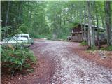 5
5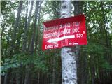 6
6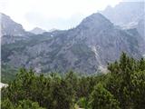 7
7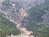 8
8 9
9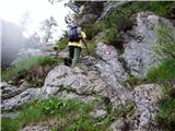 10
10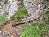 11
11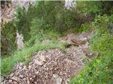 12
12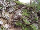 13
13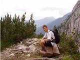 14
14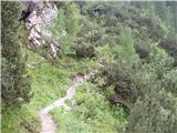 15
15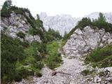 16
16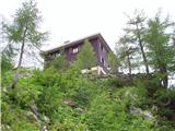 17
17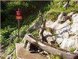 18
18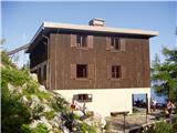 19
19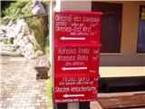 20
20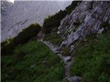 21
21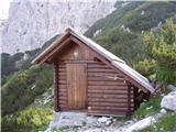 22
22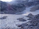 23
23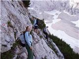 24
24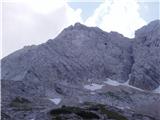 25
25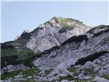 26
26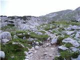 27
27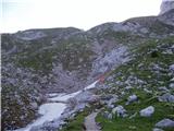 28
28 29
29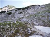 30
30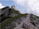 31
31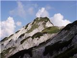 32
32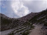 33
33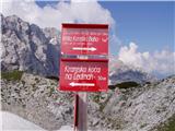 34
34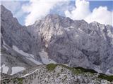 35
35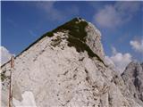 36
36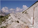 37
37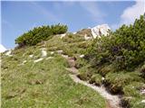 38
38 39
39 40
40
Discussion about the trip Ravenska Kočna - Ledinski vrh (hunter's way)
|
| MartinaZ26. 06. 2008 |
I'm wondering if there is any more exposed section on this trail? I'm a bit prone to vertigo and don't feel good above cliffs.
|
|
|
|
| Tadej26. 06. 2008 |
A short 5-minute section on the way to Kranjska koča is somewhat more difficult, no major cliffs, but quite steep. Since there are safety features on this part of the trail, I think it will be okay. From the hut to Ledinski vrh the trail is easy except for a short passage, which is easier than the ascent to Kranjska koča.
|
|
|
|
| MartinaZ26. 06. 2008 |
Aha, I've already been to Kranjska koča once and there was no problem. I was more worried about the part after the hut. Thanks for the reply, Tadej.
|
|
|
|
| michael6626. 06. 2008 |
At the lower cable car station there are crazy flies. As soon as you step out of the car, they attack you.
|
|
|
|
| klukc291. 07. 2008 |
is this path very demanding?
|
|
|
|
| klukc293. 07. 2008 |
I wonder if there's still any snow on that mountain
|
|
|
|
| Biser gora4. 07. 2008 |
Klukc29, the path is dry and almost not challenging at all.
|
|
|
|
| Vera6. 07. 2008 |
Would a dog that has already been to the Czech hut about 6 times without any problems (via ferrata, cables...) manage this path (to Ledinski vrh)? Thanks!
|
|
|
|
| Bali7. 07. 2008 |
Ask the dog
the hunting path is marked as easier....
|
|
|
|
| Vera14. 07. 2008 |
Dog - barely - just manages the whole path, although from Ledin downwards there are a couple of difficult spots (slippery), where we delayed a bit to get him down...
|
|
|
|
| sanja474. 10. 2008 |
Does anyone perhaps know until when Krajnska koča is open? And how much snow has fallen? Thanks
|
|
|
|
| jersy4. 10. 2008 |
The hut is at least in my opinion already closed, quite some snow has fallen as Kravvec at 1400m was whitened today too and old snow and ice is surely still there so I think winter gear is needed at least ice axe and crampons
|
|
|
|
| sebanakis5. 10. 2008 |
the hut is closed, but take winter gear anyway, maybe not needed, maybe very useful.
|
|
|
|
| andrejjerina14. 07. 2009 |
Today there was a beautiful day on Ledinski vrh with excellent views! Worth it! The protections on the hunting path and on the Slovesnki poti are in impeccable condition. Best regards Andrej
|
|
|
|
| velikanka21. 08. 2009 |
I'm asking experienced hikers if it's sensible to go to Ledinski vrh tomorrow due to the not-so-good weather forecast?
|
|
|
|
| andrejjerina21. 08. 2009 |
Tomorrow especially in the KS Alps quite some precipitation is forecast. You won't get anything from the trip or ascent if you're wet. It's worth postponing, because the ascent itself is nice. LP Andrej
|
|
|
|
| dioklecian4. 10. 2009 |
Today was our second high mountain tour with my son. I would praise the people who arranged the path and the aids for easier climbing on the path (hunter's path). I would only criticize the metal box with the summit register. It has no pen and a more or less destroyed book (I assume from rain). In my opinion, it is of wrong construction because it has no lid, but is just inserted into the compartment.
|
|
|
|
| Saten15. 10. 2009 |
Today I went to Ledinski vrh via the Lovska pot to Ledine. Snow started quite low, perhaps around 1200 to 1300 m.a.s.l. Some ice in places, but nothing more than caution was needed. Although I had crampons in my backpack, I didn't need them. At the start near the cable car loading -1 degree, at Ledine -6 degrees. At the summit I don't know, but it was a bit windy, so hat and gloves came in handy. Otherwise clarity, sun and peace; and the mix of autumn and winter - an extraordinary combination of colors and feelings.
|
|
|
|
| Saten15. 10. 2009 |
I join the previous report: at Ledinski vrh there is a summit log box without a lid, and what should have been the logbook was a block of ice today. Perhaps something could be done about both.
|
|
|
|
| nofix22. 05. 2010 |
What kind of information about conditions.
Thanks
|
|
|
|
| peterhaf14. 06. 2010 |
Is the path to Ledinski vrh already passable without winter gear (crampons and ice axe)?
Thanks for the information
|
|
|
|
| gj16. 06. 2010 |
no, or rather to the hut on Ledine without snow. That's already a nice hike. Further on you check the conditions. BEST REGARDS AND GOOD LUCK
|
|
|
|
| Parkeljc16. 06. 2010 |
On 10.06.2010 I went from below the cable car over Ledine and Jezersko sedlo to the memorial plaque on Okrešlju. Where the path is secured with pegs and wire rope THERE IS NO SNOW. A little higher than Ravenska Kočna, roughly above the markers' shelter, there are patches of snow and no problem crossing. Between Jezersko and Savinjsko sedlo there is still quite some snow, and also much lower towards Okrešlju, but as said, crossable. I recommend gaiters, as during faster descent on snow it "squirts" up the legs, i.e. into the boot tongue, which can be quite annoying.
|
|
|
|
| miha18810. 06. 2015 |
Hello,
has anyone been hiking around here recently - asking because of snow, if there's any left on exposed sections.
Thanks
|
|
|
|
| garmont11. 06. 2015 |
There is no more snow on this path.
|
|
|
|
| miha18824. 06. 2015 |
With delay, thanks for the info.
|
|
|
|
| Edi3430. 05. 2016 |
Does anyone know about the conditions on the trail from the hut towards the saddle?
|
|
|
To post a comment you must log in:
If you do not yet have a username, you must first
register.