Razdrto - Suhi vrh (Nanos) (steep way)
Starting point: Razdrto (575 m)
| Latitude/Longitude: | 45,75910°N 14,06190°E |
| |
Route name: steep way
Walking time: 3 h 20 min
Difficulty: difficult marked way
Elevation gain: 738 m
Elevation difference along the route: 950 m
Map: Nanos 1:50.000
Recommended equipment (summer): helmet
Recommended equipment (winter): helmet, ice axe, crampons
Views: 59.695
 | 2 people like this post |
Access to starting point:
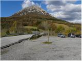
From the Ljubljana - Koper or Ljubljana - Nova Gorica highway we turn onto the Razdrto exit. We follow the road further into the village of Razdrto and then in the center of the village continue in the direction of the villages Strane and Veliko Ubeljsko. Just above the village we arrive at a large parking lot where we park.
Route description:
From the parking lot we cross the bridge over the highway, then at the intersection we continue left in the direction of Vojkova koča and Abram. After a few dozen steps on the gravel road, the signs for Nanos direct us right onto a moderately steep footpath that begins to ascend across a scenic grassy slope. After a short ascent the path passes into a belt of shrubs that higher up turns into forest. The path then turns slightly to the left and leads us to a marked junction where we continue right in the direction of the steep path towards Vojkova koča (straight or slightly left lead the gentle path and the path towards Saint Jerome).
We continue ascending moderately for some time, then the path begins to climb ever more steeply. Higher up we notice an interesting verse, and the marked path leads us to a nearby indistinct viewpoint where it turns sharply right (here an unmarked Janezova pot branches off straight ahead).
Next follows a traverse across a short scree slope. The path becomes increasingly steep and leads us to the first protections where with the help of a cable we cross a short somewhat exposed ledge. The path continues steeply up the slope surrounded by sparse forest (on this section especially when wet and during descent some extra caution is needed to avoid slipping). When higher up the forest thins even more we reach the next protections which are quite unusual for Slovenian mountains since these are not cables but chains. A short ascent over dissected rock with the help of a chain follows after which we arrive at an exceptional viewpoint from which a wide view opens.
Here the path turns slightly left and we continue ascending over bare slopes. At a few difficult spots a few more protections help us which are especially useful in winter when part of the path may be icy due to low temperatures.
A little further the path and slope level out and the path forks. We continue on the slightly right marked path (the left path leads past transmitters) which a little further is joined by the marked path from the settlement Veliko Ubeljsko.
We continue in the direction of Vojkova koča which we quickly reach through a belt of forest.
From the hut we continue on the marked path in the direction of Suhi vrh and Strane where across a meadow with a few trees we enter the forest and there ascend for a short time. A few easy walks with some short descents and ascents follow leading us to a scenic grassy slope. After the scenic section we return to the forest and begin to descend more steeply. After a few minutes of descent we reach a marked junction where we turn left following the signs for Suhi vrh (straight down leads to Strane).
A few minutes further we reach a forest road and follow it right downhill in the direction of the markings (even if we continue left on the road we can reach Suhi vrh since the paths later rejoin). At the point where we join the path from Strane we turn left onto the footpath which then ascends through the forest and returns to the road. We follow the road once more to the right and continue on it to the nearby hunting hut.
We continue the ascent for some time on the forest road then the signs for Suhi vrh – strma pot direct us right downhill (straight on the road leads the gentle path). The path first descends steeply to the bottom of a doline then begins to ascend through the forest. After a few minutes of more intense ascent we reach an emergency bivouac set up in a former military tunnel after which the path levels slightly. Only a short ascent remains and the path leads us to the scenic Suhi vrh.
Razdrto - Vojkova koča 1:45, Vojkova koča - Bukova dolina 0:35, Bukova dolina - razpotje Boljunov vrh 0:15, razpotje Boljunov vrh - razcep pod Suhim vrhom 0:25, razcep pod Suhim vrhom - Suhi vrh 0:20.

Along the route: Vojkova koča na Nanosu (729m), Odcep Janezove poti (871m), Reševnik (941m), Razpotje pod Plešo (1236m),
Vojkova koča na Nanosu (1240m), Bukova dolina (1155m), Oglarsko naselje (1162m), Razpotje Boljunov vrh (1128m), Razcep pod Suhim vrhom (1230m), Bunker pod Suhim vrhom (1297m)
Photos:
 1
1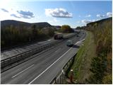 2
2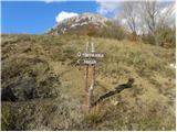 3
3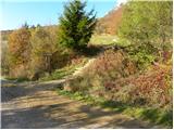 4
4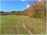 5
5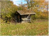 6
6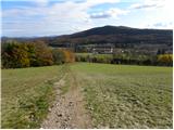 7
7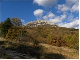 8
8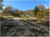 9
9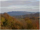 10
10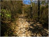 11
11 12
12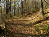 13
13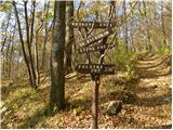 14
14 15
15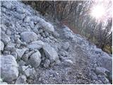 16
16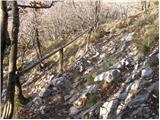 17
17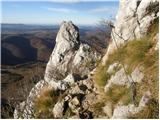 18
18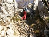 19
19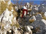 20
20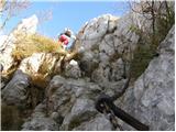 21
21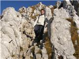 22
22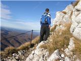 23
23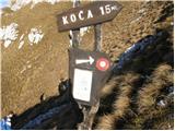 24
24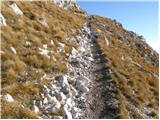 25
25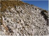 26
26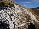 27
27 28
28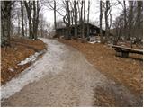 29
29 30
30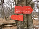 31
31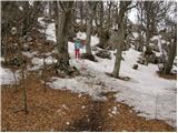 32
32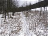 33
33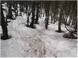 34
34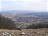 35
35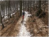 36
36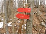 37
37 38
38 39
39 40
40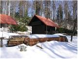 41
41 42
42 43
43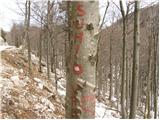 44
44 45
45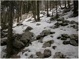 46
46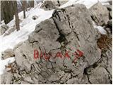 47
47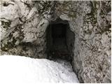 48
48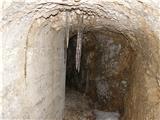 49
49 50
50 51
51
Discussion about the trip Razdrto - Suhi vrh (Nanos) (steep way)
|
| Tadej18. 03. 2009 |
If you are already on Nanos (Pleši) and have time and there is no strong wind, it is worth extending the trip to Suhi vrh, which is an hour and a half away. A nice view will open towards the Julian Alps, Postojna Basin and the Notranjska hills.
|
|
|
|
| alfaromeo1557. 02. 2010 |
I'm interested in how the path is in winter, as I saw today there is quite a bit of snow on Nanos from the ascent and the summit is in fog
best regards
|
|
|
|
| rjudnic7. 02. 2010 |
Nanos is often icy in winter, so don't go up without crampons. And if you plan to go up, choose the gentler path.
|
|
|
|
| polde17. 02. 2010 |
Hello!
Interested in the possibility of a circular path Razdrto-Vojkova koča-Suhi vrh-Strane, leaving the car above Razdrto. How much time for the path Strane - parking above Razdrto?
Thanks for answers and possible advice!
|
|
|
|
| Murglovc18. 02. 2010 |
From Stran to Razdrto about 1 hour, if you're fast even less.
|
|
|
|
| Biggie9. 05. 2010 |
Today we spent a super day on Nanos. The goulash is perfect 
|
|
|
|
| ciklama30. 10. 2010 |
My husband and I went on Thursday, 28.10.2010, along the steep path to Nanos. A strong bora wind was blowing, which became unbearable when we left the forest edge. The last 15 minutes we literally crawled on our knees; for every move, we had to wait until the gust of wind was a bit weaker. On that section, you can't turn back anymore; you simply have to persevere to the end. To top it off, the hut was closed, so we descended immediately, this time via the easier path, which was no easier either, as a strong bora was blowing there too, and the narrow trail was icy. In short, one experience and above all a test of endurance.
|
|
|
|
| Janiel743. 09. 2011 |
Today it was full at Vojkova koča as part of Zlatorogova Transverzala. Went the steep path...less detour and the goal was reached Weather fantastic! Weather fantastic!
|
|
|
|
| barbytek13. 10. 2011 |
Yesterday I was up there, no stamp anywhere...  So I wonder, where else could I get a stamp? Thanks for the answer So I wonder, where else could I get a stamp? Thanks for the answer
|
|
|
|
| Stumby24. 02. 2012 |
Is there still any snow on Nanos?... I'm planning a little walk around there on Sunday, curious about the conditions...
|
|
|
|
| miri24. 02. 2012 |
On Saturday from the Kp-Lj road it looked completely snow-free. Can send you the pic by mail, can't attach here. Regards Miri
|
|
|
|
| brinta26. 02. 2012 |
From Vojkova koča to Suhi vrh mostly snow 20-30 cm, but today the trail is already broken. Recommend gaiters. Yesterday we had to break the trail first!
|
|
|
|
| klavdipo16. 03. 2012 |
Is there already a new stamp at Suhi vrh?
|
|
|
|
| Loni16. 03. 2012 |
We're going up tomorrow, so we can check, otherwise call PD Postojna and ask, as it probably falls under that PD.
|
|
|
|
| B216. 03. 2012 |
A new stamp and new box (mounted on a post, green color) with logbook was placed on Suhi vrh on the occasion of the markers' course in Vojkova koča in May last year. During my visit in August last year, everything was still fine. Suhi vrh belongs to PD Postojna anyway. Have a nice day!
|
|
|
|
| B216. 03. 2012 |
I forgot to write earlier that the stamp was mounted on the front side of the box. Otherwise, there would be nothing strange if it was in the way of some "enthusiastic hiker". It wouldn't be the first time... Nice day!
|
|
|
|
| klavdipo16. 03. 2012 |
Thanks!
I'm also going up tomorrow!
LP
|
|
|
|
| Loni17. 03. 2012 |
The stamp is definitely there. But someone replaced the old box with a trash can. Otherwise a fun trip, just right for the morning. We returned via the gentle path. Still quite some ice in shady sections, especially towards the summit and somewhere in between under the leaves.
|
|
|
|
| klavdipo17. 03. 2012 |
I checked today and also stamped in the booklet. Otherwise a nice tour, too bad the weather was "wimpy" and didn't offer long views. LP
|
|
|
|
| B218. 03. 2012 |
I'm really surprised how Barbytek didn't see the stamp on the summit on 13.10.2011... On which summit was she looking for it, since it's been on Suhi vrh since May 2011... And a new logbook box too... Unfortunately, during my visit there was still the old logbook box - turned into a trash can - shameful for hikers!
|
|
|
|
| Kigeot24. 10. 2014 |
Route instructions:
After a few minutes of further walking we reach a forest road, which soon brings us to the hunting hut.
When we reach the forest path, do we go left or right? I didn't see the hunting hut... and the path didn't seem steep to me...
|
|
|
|
| valerija11224. 10. 2014 |
The well-marked path takes us along the road past the hunting hut, which is on the left side of the road as we ascend. A little further from the hut, there is a marked turn-off to the right onto the steep path. Did you perhaps go straight on the gentle one? I wish you many beautiful moments in the mountains.
|
|
|
|
| B225. 10. 2014 |
At the directional signs (in picture 25), which have not been "leaning" against the tree for at least three years - but are mounted on a metal pole, we go left and after about 10 minutes of almost flat walking we reach the access road. Here we turn right (there are also old wooden signs on the beech tree) and follow it for about a kilometer to the hunting hut right next to the road on the left side. A little further on, we watch for the turn-off to Suhi vrh (sign on the beech tree, picture 33, which we can easily miss when the trees are leafy). You probably went straight at the signs and later left through the valley, where there is also a fairly trodden path that runs almost flat, which was once marked (some markings can still be found). In this case, the forest road and the hunting hut were high above you.
|
|
|
|
| Kigeot25. 10. 2014 |
Yeah, somewhere at picture 28 I probably took the other path... Along the access road at the old signs I went right downhill (towards Suhi vrh) for a good 500-800m, then there was a sign for Suhi vrh to the left, a slightly ascending path..
It doesn't matter, next time I'll find this path too.. Autumn is very beautiful in those forests, especially when it's sunny.
|
|
|
|
| B225. 10. 2014 |
Exactly, you missed the path. You went too far ahead. But the path you took is also very nice...
|
|
|
|
| Hribolazec816. 03. 2021 |
For adrenaline lovers, it's worth extending (to bypass the via ferrata), start at the other end, namely via Gradiska tura (Furlanova and Otmarjeva route), to Furlanovo zavetišče pri Abramovu, then towards Suhi vrh, from Suhi vrh to Nanos, Grmada na Nanosu and down to the valley (True, you need two cars)
|
|
|
|
| padez6. 03. 2021 |
For this tour you mentioned, you need two cars if there are 10 participants in the group.
You start at Kamp Tura in Gradiscu pri Vipavi and ascend via Gradiska tura or via Plaz and continue to Abrama and further to Suhi vrh and then to Vojkova koča and via Grmada and past the church to the hunting hut and past the church Sv. Miklavza to the starting point
But here there's walking for the whole day...
|
|
|
|
| padez6. 03. 2021 |
For this tour you mentioned, you need two cars if there are 10 participants in the group otherwise not.
You start at Kamp Tura in Gradiscu pri Vipavi and ascend via Gradiska tura or via Plaz and continue to Abrama and further to Suhi vrh and then to Vojkova koča and via Grmada and past the church to the hunting hut and past the church Sv. Miklavza to the starting point, where your car is waiting.
But here there's walking for the whole day...
|
|
|
To post a comment you must log in:
If you do not yet have a username, you must first
register.