Razdrto - Vojkova koča na Nanosu (gentle path)
Starting point: Razdrto (575 m)
| Latitude/Longitude: | 45,75910°N 14,06190°E |
| |
Route name: gentle path
Walking time: 2 h 15 min
Difficulty: easy marked way
Elevation gain: 665 m
Elevation difference along the route: 665 m
Map: Nanos 1:50.000
Recommended equipment (summer):
Recommended equipment (winter): ice axe, crampons
Views: 289.544
 | 4 people like this post |
Access to starting point:
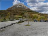
We leave the Primorska motorway at the Razdrto exit; upon reaching the regional (old) road, we follow the signs for Razdrto. A little further on, after the bus station, we turn right towards the centre of the settlement; at the intersection there are also signs for Nova Gorica (straight ahead on the old road towards Koper). In Razdrto we then turn right once more, this time towards Strane and Veliki Ubeljsek; before crossing the motorway we park at the large gravel car park.
Route description:
From the car park we cross the bridge over the motorway, then at the junction we continue left towards Vojkova koča and Abram. After a few dozen steps on the gravel road, the signs for Nanos direct us right onto a moderately steep footpath that begins to ascend across a scenic grassy slope. After a short climb the path enters a belt of shrubs that higher up turns into forest. The path then turns slightly left and brings us to a marked junction, where we continue left or straight towards St. Jerome and the gentle path to Vojkova koča (right leads the steep path to Vojkova koča).
A little further the path leads across a scenic meadow from which we have a fine view of the surroundings, then returns to the forest through which it continues to ascend transversely to the left. The gentle path mostly leads us northwest; higher up it brings us out of the forest onto more grassy slopes where it becomes somewhat steeper. With beautiful views of the hilly landscape we then reach the edge of the Nanos plateau, where paths from Lozice and Podnanos join from the left.
We continue right towards Vojkova koča (left the church of St. Jerome, 3 minutes) along the path that a few steps further brings us to a less noticeable junction where an unmarked path to Grmada branches left. We continue slightly right on the marked path that for some time ascends parallel to the road. The path then moves a little further right away from the road and passes onto the scenic north-western edge of Nanos. Here the so-called Janezova pot joins almost imperceptibly from the right, and we continue straight on the wide trail that leads us towards the transmitters on Nanos. Just before the transmitters the path turns left, descends into a belt of forest and then, passing the monument to Janko Premrl - Vojko, brings us to Vojkova koča on Nanos.
Razdrto - Žingarca 0:25, Žingarca - edge of the Nanos plateau 1:15, edge of the Nanos plateau - Vojkova koča 0:35.

Along the route: Žingarca (729m), Rob nanoške planote (1057m), Razgledišče (1191m)
Photos:
 1
1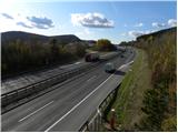 2
2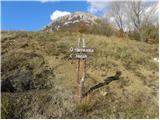 3
3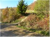 4
4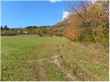 5
5 6
6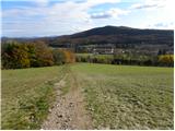 7
7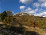 8
8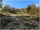 9
9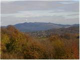 10
10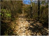 11
11 12
12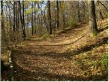 13
13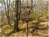 14
14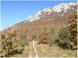 15
15 16
16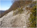 17
17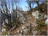 18
18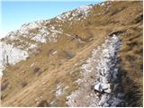 19
19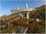 20
20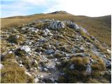 21
21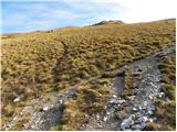 22
22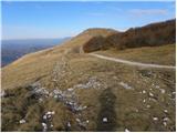 23
23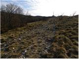 24
24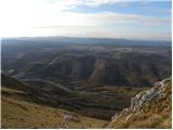 25
25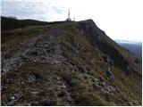 26
26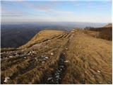 27
27 28
28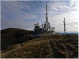 29
29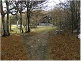 30
30 31
31
Discussion about the trip Razdrto - Vojkova koča na Nanosu (gentle path)
|
| Darxta18. 06. 2012 |
WARNING:
On Saturday we went up, great weather, but when we returned to the parking lot, the neighboring car had a broken window.
The parking lot is probably very attractive to various burglars, so I recommend not leaving anything valuable in visible places or put everything in the trunk, and close the windows completely. Better to have a 10 degrees hotter car and wait a bit longer to air it out than risk a break-in.
Best
|
|
|
|
| robi196617. 10. 2012 |
On Nanos there is Vojkova koča, I should praise the staff, they are very friendly, obliging, food is excellent, prices great, cleanliness top-notch, in short keep it up.
CONGRATULATIONS!!!
|
|
|
|
| TFerarri26. 01. 2013 |
What is the gentle path like now in winter time, how much snow is there and are crampons necessary for descent?
Thanks for the info.
|
|
|
|
| laik1. 02. 2013 |
I'm also interested in conditions...going Sunday and given unfamiliarity (see nick) better check beforehand how it is...thanks 
|
|
|
|
| stasa_t2. 02. 2013 |
I was up there yesterday, but conditions on the path tomorrow will probably be quite different compared to yesterday's (according to the weather forecast). The path yesterday was quite muddy (slippery), especially in the initial part, there was still some snow in places, and the last part towards the plateau was actually completely covered with snow. Crampons tomorrow will probably not be superfluous, above all take care and have some experience
|
|
|
|
| laik2. 02. 2013 |
thanks a lot.... I'd rather wait a bit more
|
|
|
|
| lann15. 05. 2013 |
What kind of food do they offer in the hut? And what are the prices?
|
|
|
|
| Karletto16. 05. 2013 |
goulash, farmer's platter, beans, dumplings, potica, struklji etc.
prices from 4 eur onwards
|
|
|
|
| Becar17. 05. 2013 |
Are these already the new caretakers? Namely, there was a tender this year.
|
|
|
|
| urarrr17. 05. 2013 |
They extended the old ones for one year. Because there are few who would live up there and work properly. In short, they didn't get anyone else... But they got two patients who didn't even know how to get to the hut...
|
|
|
|
| Becar17. 05. 2013 |
I will also say hats off to the current ones, because as I read that tender, you have to be a real master to survive financially.
|
|
|
|
| maja.vlah116. 03. 2014 |
Are there any fixed cables on the path, I'm asking because I would take my dog with me.
|
|
|
|
| Strucko16. 03. 2014 |
There are no fixed cables, this path is also suitable for children.
|
|
|
|
| markulin27. 12. 2014 |
Today a hunting dog of German pointer breed got lost under Vojkova koča. If anyone meets or sees it, it has the owner's number under the collar (Petra, 040 370 828). Thanks everyone!
|
|
|
|
| polo1113. 05. 2015 |
On Sunday we would like to go to Nanos, what are the conditions like?
|
|
|
|
| lumi15. 05. 2015 |
If anyone is doing the RTV traverse, please write if the stamp at the tower has already been replaced with a new one - the old one was destroyed by idiots who walk undisturbed through our beautiful Slovenian land!?
|
|
|
|
| BenečijaHrib28. 11. 2015 |
We often saw Nanos from the highway, but today we went up with our almost 9-year-old son via the gentle path. Above 800 m ca. 20 cm snow, but wind blew it off the top. Wonderful - view, sun and wind playing with snow, at the top near the hut ice on the trees.
Don't go up without hiking poles, occasionally slippery on steeper parts. Chains for shoes would be excellent.
|
|
|
|
| frover18. 03. 2017 |
Were up there yesterday. Nice path, well marked. Hut pleasant. Food under criticism (goulash and dumplings), small and uneatable  Shame! No wonder there's more and more food from the backpack Shame! No wonder there's more and more food from the backpack 
|
|
|
|
| cdgk11. 06. 2017 |
End of May we were at Nanos. The hut keeper was very unfriendly. In the hut we asked if they had another stamp, as the one attached to the hut is not the "real" stamp from the traverse. The keeper replied quite rudely "the one you like to steal so much?!" and literally yelled at us (for an unknown reason) in front of the other guests. After she gave us a series of comments on how we would ruin the stamp if we stamped the booklet ourselves, how hikers steal stamps, and if we realize it costs the keeper 30 euros, she finally stamped our booklets.
We have conquered quite a few mountains, but we have never experienced such behavior... I think hikers don't deserve such treatment either. We don't deserve generalizations that all hikers ruin everything and steal everything. We would rather give everything away than intentionally harm anyone. If we entered the hut friendly and in good spirits, we ended up with a somewhat bitter day.
|
|
|
|
| an_4. 09. 2017 |
Yesterday we set out on the described path. It's very beautiful, in places it was still a bit slippery in the morning due to the rain the previous day, but that was to be expected. Despite walking very leisurely and stopping twice, we reached the top in 1h 45min. The views are indescribably beautiful, so we'll definitely come back.
|
|
|
|
| Aysa1013. 01. 2018 |
Today we did the ascent on this path, super satisfied despite bad weather at the top. Icy wind and fog made us ask the caretakers if we could enter with two dogs, even though the sign prohibits it. The no answer was expected, but here's the criticism, there were two dogs inside. Double standards? In the end we were allowed to warm up with the dogs in the hallway, where they lay quietly even during hikers entering/exiting and were interesting to most people. Hut's loss, we went for lunch in the valley... Plus the fact that the lady refused the piece of foil on the returned tray, saying it's not theirs. Shameful. Great mountain, great weather experience, hut failed completely.
|
|
|
|
| D3nta12. 04. 2019 |
Nice gentle trail, little rocky terrain, nice weather, only on the return we made a mistake. We descended a steep path, not for everyone. Very dangerous. Only for the experienced.
|
|
|
|
| masker11. 05. 2019 |
Hello!
Anyone heading to the top of Nanos at this time should take into account that the hut is currently closed (almost a month already!). If not, at least call the caretaker of Vojkova koča: Tel: 031 791 002.
|
|
|
|
| masker11. 05. 2019 |
But if this news is too much for some passionate hiker or female hiker (come on, who cares!!), then ....... safe steps with sun in the eyes and wind in the hair!!!!
|
|
|
|
| zlatica11. 05. 2019 |
masker, the information is certainly useful. Thanks.
|
|
|
|
| turbo12. 05. 2019 |
I apologize  I overlooked that it will open only from June onwards I overlooked that it will open only from June onwards 
|
|
|
|
| mirank12. 05. 2019 |
Those up there throw white bread around, as it's full there all year round. As for me, I won't cross the threshold until they change the staff of that tavern. It must have been a few years ago when I ordered a beer and a glass to share with my wife. She told me it could be plastic because they have no water and you can burn the plastic. It really lifted me; you're not in the Himalayas; there's a nice drivable road to the hut and that's how the caretakers should be?
|
|
|
|
| BaroA13. 05. 2019 |
One piece of information regarding the above writing. The hut on Nanos has a new caretaker since last weekend, who with his team is already taking care of visitors. Go check it out yourselves The link to the schedule was already posted by user sh before me.
|
|
|
|
| Krux1. 11. 2024 17:38:09 |
🐶 With a dog that's otherwise used to hiking in the mountains, it was a bit dangerous for my taste. The path is mostly on the side of the slope that's quite exposed - cliff on the left all the time. When you come out of the forest to the clearing, two dogs can hardly meet, better leash them then. Also because there's a cliff at the viewpoint and mine of course went rolling right next to the cliff and it was quite close ... I don't recommend this ascent with a playful young and disobedient dog.
|
|
|
To post a comment you must log in:
If you do not yet have a username, you must first
register.