Robanov kot - Kocbekov dom na Korošici
Starting point: Robanov kot (650 m)
| Latitude/Longitude: | 46,39480°N 14,70300°E |
| |
Walking time: 4 h
Difficulty: difficult marked way
Elevation gain: 1158 m
Elevation difference along the route: 1300 m
Map: Kamniške in Savinjske Alpe 1:50.000
Recommended equipment (summer): helmet
Recommended equipment (winter): helmet, ice axe, crampons
Views: 32.837
 | 3 people like this post |
Access to starting point:
Through the Volovljek pass (Kranjski Rak) or from Mozirje we drive to Luče, then we follow the signs for Solčava and Logarska dolina. When we arrive in the settlement Robanov Kot, the signs for the alpine valley Robanov kot direct us left onto a side road, along which we drive to the parking lot near the farm Roban, where we park. We can also park already 500 m lower, where there is another organized parking lot, but we must not park on the parking lot of the pension Govc-Vršnik, because consequently there is no space for the guests of the pension.
Route description:
If we've parked on the lower parking lot we continue on the road to the parking lot at the farm Roban, and only a few meters ahead from the last parking lot we arrive at a crossroads, where we continue straight ahead on the road where there is a barrier (right Strelovec).
The road towards Robanova planina then goes into the forest and brings us to a junction, where we continue straight ahead further on the road (left partisan hospital 45 min).
The road then brings us out of the forest onto Robanov travnik, where a nice view opens up on the surrounding walls. On the other side of the meadow the road goes back into the forest and ascends somewhat more steeply. This is followed by crossing a pasture fence and soon after we come out of the forest onto the panoramic Robanova planina.
From the planina we continue following the signs "Korošica, Ojstrica" and the wide path brings us into the forest already after a few meters. After a short ascent the path turns left and crosses several torrent beds. We ascend again through the forest and soon reach a small waterfall below the slopes of Molička peč and Velika Zelenica. Here the path turns right and begins to ascend quite steep slopes with the aid of a steel cable and some pegs. This is followed by another short ascent through the forest on somewhat gentler slopes, then we reach a somewhat more rocky section of the path. The path then ascends for quite some time on steep slopes above the torrent gully. The path here is routed through nice passages and is very well secured with a steel cable, so the ascent does not cause major difficulties. The path is also assisted by numerous pegs and steps carved into the rock. This is followed by a few more steeper ascents with the aid of the steel cable and pegs, then the path brings us to gentle slopes covered with dwarf pines. The path then through the dwarf pines in a short descent brings us to a junction, where we continue straight in the direction of Korošica (right Molička planina 10 minutes). This is followed by a short ascent and we join the path from Planina Podvežak, which after a further short traverse ascent brings us to Sedelce. From Sedelce we descend towards the Korošica plain. After this descent only a ten-minute walk to the hut remains.
Robanov kot - Robanova planina 1:00, Robanova planina - Korošica 3:00.

Photos:
 1
1 2
2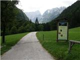 3
3 4
4 5
5 6
6 7
7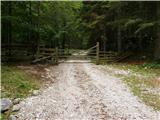 8
8 9
9 10
10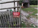 11
11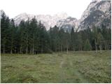 12
12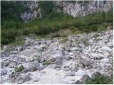 13
13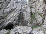 14
14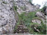 15
15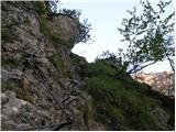 16
16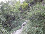 17
17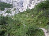 18
18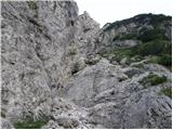 19
19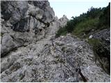 20
20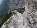 21
21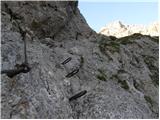 22
22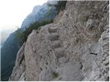 23
23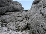 24
24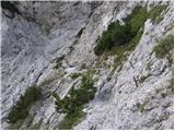 25
25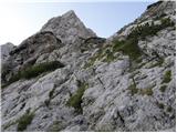 26
26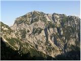 27
27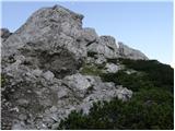 28
28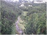 29
29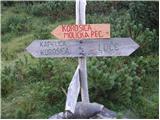 30
30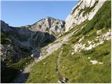 31
31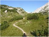 32
32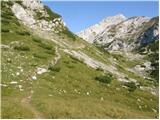 33
33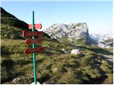 34
34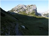 35
35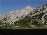 36
36 37
37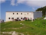 38
38
Discussion about the trip Robanov kot - Kocbekov dom na Korošici
|
| Luciano678. 09. 2009 |
Beautiful hike, varied but not too demanding, impressions are unique...
|
|
|
|
| petruša19. 05. 2010 |
On Saturday we plan to go to Korošica, I'm interested if there's still any snow on this path or if the path is nicely walkable. lp.
|
|
|
|
| geppo19. 05. 2010 |
I see you don't have an answer yet!
I haven't walked there, but I assume there are patches of snow in the upper part (based on experiences from previous years). For someone a bit experienced and accustomed, it's no problem. Still, if you're not quite used to such conditions, I'd rather go from Podvolovjeka (Planina Podvežak). There at least you're not in steep terrain. Here every slip can be dangerous.
Maybe someone who has been wandering there will answer you.
It's a very shady side there...
Lp
|
|
|
|
| lily5. 06. 2013 |
On Sunday I'd like to go to Korošica from Robanov kot. I'm interested if anyone knows if there's still any snow on the path. lp
|
|
|
|
| KORENINC17. 07. 2013 |
Nice greetings to all, I'm interested if the path is dangerous as they say. Is it really well secured.
Best regards.
|
|
|
|
| ms_primoz17. 07. 2013 |
Recently we discussed on the portal that there are no dangerous paths. Only man is dangerous. Of course, you have to be careful on all paths. Good luck and safe steps.
|
|
|
|
| Zebdi17. 07. 2013 |
KORENINC, the path is well secured throughout and will not pose a problem for the experienced.
|
|
|
|
| dvojcica15. 12. 2016 |
Experts in this matter, please give your opinion: where could the comments from a week ago have disappeared to. Thanks and best regards
|
|
|
|
| redbull15. 12. 2016 |
Where else, into pieces
|
|
|
|
| mukica15. 12. 2016 |
Where they belong, skeletons are not pulled out of closets... it will be necessary to put up a sign in the hut too....
Solve problems, inconveniences immediately, later complaints will not be considered
|
|
|
|
| redbull15. 12. 2016 |
That's right Marty
|
|
|
|
| jprim15. 12. 2016 |
@dvojcica
Comments, including my 2, went to the trash, maybe you didn't read my post ... , as I myself suggested that the moderator delete the stuff.
It's not possible to comment publicly on the forum about some person and their problems.
LP!
|
|
|
|
| korl16. 12. 2016 |
jprim and mukica - the caretakers' problems are our troubles. But do we have to be silent because of that? Just like in families long ago, when children cried because of abuse, and neighbors nicely said they should sort it out themselves 
|
|
|
|
| jprim16. 12. 2016 |
Korl
You're talking nonsense, there's a lot of abuse today, ... I'm just saying that a discussion about some grievance or problem with the hut keeper can't be public in this way - on this forum, because in that case we're talking about public mudslinging.
Best regards!
|
|
|
|
| mukica17. 12. 2016 |
korl... I agree that it's necessary to speak about the matter, but half a year later it's a bit late... firstly looking at sokriva because she knew about it and didn't react
|
|
|
|
| Simona97. 07. 2017 |
And does anyone perhaps know the street of this parking lot?
|
|
|
|
| dr_6357. 07. 2017 |
@ Simona9
This is not a town. In villages there are only house numbers which usually don't follow each other. Sometimes from 5 to 6 there are already kilometers, and five others in between
You're probably interested in the exact position of the starting point. Coordinates of the starting point are at the top of the page.
Tourist farm Govc-Vršnik (picture 2 from the description) is at the address Robanov kot 34.
I hope I helped you.
|
|
|
|
| Janez110. 07. 2018 |
Does anyone have information on how it is now with the SPP stamp at Korošica? Are the logbook and stamp perhaps somewhere near this really unfortunate fire site? Thanks!
|
|
|
|
| Hribovc8210. 07. 2018 |
Janez1
On 8.7 we passed by Korošica and there is no stamp anywhere nearby.
|
|
|
|
| UROS110. 07. 2018 |
I was also there that Saturday 7.7.2018 and can confirm that there is neither a logbook nor a stamp! Unfortunately...
|
|
|
|
| danielenidoma21. 07. 2018 |
Hi, is there near the site of the burned-down hut on Korošica some shepherd's hut or anything to shelter from a storm? Thanks for info, best regards
|
|
|
|
| coffee21. 07. 2018 |
About 30 minutes away there is an old hut and a chapel, but they are probably locked, so only getting wet remains for you there.
|
|
|
|
| ma&pa5. 10. 2018 |
Exactly this tour we hiked with a friend on Saturday ... I recommend it to everyone, even though the hut is currently closed and we had a bit bad weather at the top. #coffee#res is an old hut and little church, but it's worth stopping to drink coffee from the backpack and enjoy.
|
|
|
|
| Mara6619. 04. 2019 |
We are planning a hike to Korošica and further to Ojstrica and back. We are interested in the conditions on Ojstrica? Snow? So we can prepare.
Regarding the stamp at Korošica. How is that?
Thanks
|
|
|
|
| Jani33326. 02. 2020 |
Hello,
I'm interested where to get the SPP stamp?
Some say in the eagle's nest, others that it's somewhere at the burned hut.
thanks for reply
|
|
|
|
| magacoprnon26. 02. 2020 |
The stamp is placed on a container near the burned hut on Korošica.
|
|
|
|
| Jani33326. 02. 2020 |
magacoprnon
thanks
|
|
|
To post a comment you must log in:
If you do not yet have a username, you must first
register.