Rudno polje - Mali Triglav (via Kredarica)
Starting point: Rudno polje (1347 m)
| Latitude/Longitude: | 46,34580°N 13,92360°E |
| |
Route name: via Kredarica
Walking time: 6 h 5 min
Difficulty: very difficult marked way
Elevation gain: 1378 m
Elevation difference along the route: 1630 m
Map: Triglav 1:25.000
Recommended equipment (summer): helmet, self belay set
Recommended equipment (winter): helmet, self belay set, ice axe, crampons
Views: 58
 | 1 person like this post |
Access to starting point:
From the Ljubljana - Jesenice highway, we exit at Lesce and continue on the road towards Bled. In Bled, at the traffic light, signs for Pokljuka direct us right. We then drive through Gorje and past the abandoned ski resort Zatrnik to Rudno polje on Pokljuka (large parking lot, barracks and shooting range).
Route description:
At the end of the parking lot, a gravel road branches off to the right, along which there are signposts for Triglav. We head onto the mentioned road, which gently ascends and after ten minutes of walking brings us to the Viševnik ski resort. We continue along the road, from which a marked path to Triglav soon branches off to the left.
We continue in the direction of Triglav and after a few minutes of moderate ascent, we arrive at a forest road, which we follow for only a few meters (until here, it was sometimes possible by car). The marked path then turns right and steepens for a short time, after ten minutes the steepness eases, and the path slowly transitions to steep slopes. Across the steep slopes, the path mostly gently descends and turns more and more to the right. A bit further, we will notice the Konjščica pasture left below us. Our path then stops descending and transitions from the forest to dwarf pines. The path, which ascends again, then leads us under steep cliffs and soon after brings us to a crossroads, where we join the path from Konjščica pasture.
From here, a short ascent follows, and the path brings us to a beautiful small valley called Jezerce, where it splits. There are also signposts that direct us left (right Srenjski preval, Viševnik Blejska koča na Lipanci...), and in the continuation, the initially gentle path brings us to the spring below Studorski preval. After the spring, the path gradually becomes steeper, from the left side of the torrent it crosses higher to the right side, where we transition to a grassy slope, the path along which we ascend is still stony. There follows an ascent in a few switchbacks and we ascend to Studorski preval, from which a beautiful view opens to the mountains above Bohinj.
Here, a demanding path from Srenjski preval joins us from the right, and from our path, unmarked tracks to Ablanca and Veliki Draški vrh also branch off.
From the saddle, we first descend steeply for a short time, then the path turns to the right direction, and then for a longer time with some short easy ascents and descents, we traverse the slopes to the left. From the slopes of Veliki Draški vrh, we gradually arrive at the slopes of the massive Tosc, and with beautiful views, we continue past the branch of the path to Tosc and the crossroads, where the path from Uskovnica joins us from the left.
At all crossroads, including the one where the partially abandoned path that leads over Zgornji Tosc pasture joins us, we continue straight, the path gradually brings us to the steeper and also precipitous southwest slopes of Mount Tosc, where there was a landslide years ago, so some additional caution is needed due to falling rocks. Over the precipitous part, a fairly wide path leads, so there are no special difficulties in this part, when the slope becomes less steep, the path from Stara Fužina or Voje valley joins us from the left.
We continue straight along the wider marked path towards Triglav, which continues north, leading us along the western slopes of Tosc, the still gentle path then brings us over a few screes to Vodnikov dom on Velo polje, where there is the next crossroads.
Here too, we continue straight in the direction of Triglav, the path begins to ascend transversely along the slopes of Vernar, higher it also becomes technically demanding. There follows some traversing, where a steel cable helps us, higher we arrive at a steep jump, where with the help of numerous pegs and steel cable, we ascend stone stairs.
The path ahead flattens, the slope becomes less steep and near Konjsko sedlo also somewhat more grassy.
To Konjsko sedlo, we descend easily, from the marked crossroads on the saddle, we head straight on the path in the direction of Triglavski dom na Kredarici and Staničev dom under Triglav (left Dom Planika under Triglav, right Krma valley), just a few steps further, the path splits again.
We continue slightly left in the direction of Kredarica (slightly right Dom Valentina Staniča) and in the continuation, we ascend transversely over numerous gullies, but crossing them is mainly not demanding. In the continuation, the path becomes technically more difficult and in some parts, some safety devices help us for easier and safer progress, mainly steel cables, there are also some pegs.
At an altitude of a bit less than 2300 meters, we merge with the technically easier path from Krma valley, we continue left in the direction of Kredarica and Triglav.
When a few minutes further the path flattens even more, to the left branches the path past Snežna konta and over Štapce towards Dom Planika under Triglav, we continue right and initially continue quite gently, then we ascend to the ridge above Vrh Snežne konte, the peak which during the ascent over Kalvarija we looked at from below upwards.
Here the path becomes steeper again, we follow such path all the way to Triglavski dom na Kredarici.
In front of the hut, at the chapel of Marija Snežna, the path from Kot valley joins us from the right, which leads past Dom Valentina Staniča, we continue along the left side of the hut and behind the hut, the path from Vrata valley joins us from the right, namely the paths over Prag and Tominškova pot.
We continue left in the direction of Triglav and along the technically still undemanding path, we descend to Ledeniški preval, from where we start ascending towards the wall of Mali Triglav. Here we follow the markings and the larger marking visible from afar, near which the very demanding path to Triglav begins.
Initially, we ascend the still not very steep slope with the help of some pegs and individual steel cables, but when we arrive at the wall of Mali Triglav, we start ascending transversely to the left, where years ago steel cables were added to the pegs, so it is possible to self-belay with a self-belay set. There follow some quite steep and exposed ascents, where we are careful not to slip, in the part where there is stones on the path, we must also be careful not to trigger stones as this can be deadly dangerous for hikers below us. The path ahead is quite narrow and with a larger number of visitors, traffic jams can occur due to difficult passing between mountaineers.
Higher, the steepness eases and from the left, the path from Dom Planika under Triglav joins us, namely the path over Mali Triglav, which we reach just a little further.
Starting point - Taborni prostor 0:10, Taborni prostor - Klanci 1:25, Klanci - Jezerce 0:05, Jezerce - Studorski preval 0:30, Studorski preval - Planina Zgornji Tosc 0:35, Planina Zgornji Tosc - Na Zagonu 0:20, Na Zagonu - Vodnikov dom 0:20, Vodnikov dom - Konjsko sedlo 0:30, Konjsko sedlo - Kalvarija 0:55, Kalvarija - Triglavski dom 0:35, Triglavski dom - Ledeniški preval 0:05, Ledeniški preval - Mali Triglav 0:35.

Along the route: Taborni prostor (1369m), Klanci (1678m), Jezerce (1719m), Izvir pod Studorskim prevalom (1746m),
Studorski preval (1892m), Planina Zgornji Tosc (1849m), Na Zagonu (1819m),
Vodnikov dom (1817m), Konjsko sedlo (2020m), Kalvarija (2288m),
Triglavski dom na Kredarici (2515m), Ledeniški preval (2484m)
Photos:
 1
1 2
2 3
3 4
4 5
5 6
6 7
7 8
8 9
9 10
10 11
11 12
12 13
13 14
14 15
15 16
16 17
17 18
18 19
19 20
20 21
21 22
22 23
23 24
24 25
25 26
26 27
27 28
28 29
29 30
30 31
31 32
32 33
33 34
34 35
35 36
36 37
37 38
38 39
39 40
40 41
41 42
42 43
43 44
44 45
45 46
46 47
47 48
48 49
49 50
50 51
51 52
52 53
53 54
54 55
55 56
56 57
57 58
58 59
59 60
60 61
61 62
62 63
63 64
64 65
65 66
66 67
67 68
68 69
69 70
70 71
71 72
72 73
73 74
74 75
75 76
76 77
77 78
78 79
79 80
80 81
81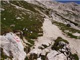 82
82 83
83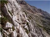 84
84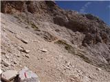 85
85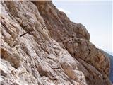 86
86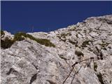 87
87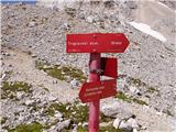 88
88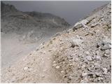 89
89 90
90 91
91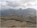 92
92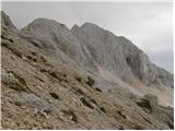 93
93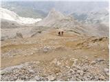 94
94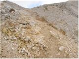 95
95 96
96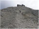 97
97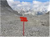 98
98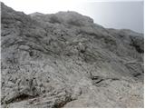 99
99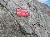 100
100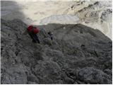 101
101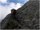 102
102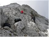 103
103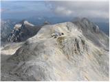 104
104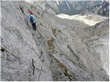 105
105 106
106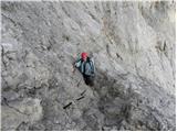 107
107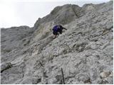 108
108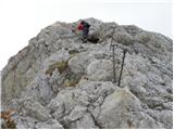 109
109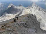 110
110 111
111 112
112 113
113
Discussion about the trip Rudno polje - Mali Triglav (via Kredarica)
To post a comment you must log in:
If you do not yet have a username, you must first
register.