Rudno polje - Triglav (via Kredarica)
Starting point: Rudno polje (1347 m)
| Latitude/Longitude: | 46,34580°N 13,92360°E |
| |
Route name: via Kredarica
Walking time: 6 h 40 min
Difficulty: very difficult marked way
Elevation gain: 1517 m
Elevation difference along the route: 1800 m
Map: Triglav 1:25.000
Recommended equipment (summer): helmet, self belay set
Recommended equipment (winter): helmet, self belay set, ice axe, crampons
Views: 131.651
 | 6 people like this post |
Access to starting point:
From the Ljubljana-Jesenice motorway, take the Lesce exit and follow the road towards Bled. In Bled, at the traffic light with signs for Pokljuka, turn right. Continue through Gorje and past the abandoned Zatrnik ski slope to Rudno polje on Pokljuka (large parking lot, barracks and shooting range).
Route description:
At the end of the parking lot, a gravel road branches off to the right, with signposts for Triglav. Head onto this road, which gently ascends and after ten minutes of walking brings us to the Viševnik ski slope. Continue along the road, from which a marked path to Triglav soon branches off to the left.
Continue towards Triglav and after a few minutes of moderate ascent, we reach a forest road, which we follow for just a few meters (it used to be possible to drive by car up to here). The marked path then turns right and ascends more steeply for a short time, after ten minutes the steepness eases, and the path gradually leads onto steep slopes. Across the steep slopes, the path mostly gently descends and increasingly turns to the right. A bit further, we will notice the Konjščica pasture to our left below us. Our path then stops descending and transitions from the forest into dwarf pines. The path, which ascends again, leads us under steep cliffs and soon brings us to a junction where we join the path from the Konjščica pasture.
From here follows a short ascent and the path brings us to a beautiful valley called Jezerce, where it splits. There are also signposts that direct us left (right Srenjski preval, Viševnik Blejska koča na Lipanci...) and the initially gentle path brings us to the spring below Studorski preval. After the spring, the path gradually becomes steeper, from the left side of the torrent higher up it crosses to the right side, where we reach a grassy slope, the path we ascend is still rocky. Follows an ascent in a few switchbacks and we climb to Studorski preval, from which we get a nice view of the mountains above Bohinj.
Here, a demanding path from Srenjski preval joins us from the right, and from our path, unmarked trails also branch off to Ablanca and Veliki Draški vrh.
From the saddle, we first descend more steeply for a short time, then the path turns to the right direction, and we then cross the slopes to the left for a long time with some shorter easy ascents and descents. From the slopes of Veliki Draški vrh, we gradually reach the slopes of the massive Tosc, and with nice views we continue past the branch to Tosc and the junction where the path from Uskovnica joins us from the left.
At all junctions, including the one where a partly abandoned path leading over the Zgornji Tosc pasture joins us, continue straight, the path gradually brings us to steeper and also exposed southwestern slopes of the Tosc mountain, where there was a landslide a few years ago, so some extra caution is needed due to falling rocks. Across the exposed section runs a fairly wide path, so there are no special difficulties in this part, but when the slope becomes less steep, the path from Stara Fužina or the Voje valley joins us from the left.
Continue straight on the wider marked path towards Triglav, which continues north, leading us along the western slopes of Tosc, the still gentle path brings us over some scree to Vodnikov dom on Velem polju, where the next junction is.
Here too, continue straight towards Triglav, the path begins to ascend transversely along the slopes of Vernar, higher up it also becomes technically demanding. Follows some traversing, where a wire cable assists us, higher up we reach a steep drop, where with the help of numerous pegs and a wire cable we climb up rocky steps.
The path ahead levels out, the slope becomes less steep and near Konjsko sedlo also somewhat more grassy.
We easily descend to Konjsko sedlo, from the marked junction at the saddle we head straight onto the path towards Triglavski dom on Kredarica and Staničev dom pod Triglavom (left Dom Planika pod Triglavom, right Krma valley), just a few steps ahead the path splits again.
Continue slightly left towards Kredarica (slightly right Dom Valentina Staniča) and then ascend transversely across numerous gullies, where crossing them is generally not demanding. Further on, the path becomes technically more difficult and on some sections, some safety devices, mainly wire cables, and some pegs assist for easier and safer progress.
At an altitude of just under 2300 meters, we join the technically easier path from the Krma valley, and we continue left towards Kredarica and Triglav.
When a few minutes ahead the path levels out further, a path branches left past Snežna konta and over Štapce towards Dom Planika pod Triglavom, we continue right and first continue fairly gently, then ascend to the ridge above Vrh Snežne konte, the summit of which we saw from below during the ascent over Kalvarija.
Here the path becomes steeper again, and we follow it all the way to Triglavski dom on Kredarica.
In front of the hut, at the chapel of Marija Snežna, the path from the Kot valley joins us from the right, passing Dom Valentina Staniča, we continue along the left side of the hut and behind the hut the path from the Vrata valley joins us from the right, namely the paths over Prag and Tominškova pot.
Continue left towards Triglav and descend on a still technically undemanding path to Ledeniški preval, from where we begin to ascend towards the ridge of Mali Triglav. Here we follow the marks and the larger one visible from afar, near which the very demanding path to Triglav begins.
Initially, we ascend a not yet very steep slope with the help of some pegs and individual wire cables, when we reach the ridge of Mali Triglav, we begin to ascend transversely to the left, where wire cables were added to the pegs a few years ago, allowing self-belaying with a via ferrata set. Follows some quite steep and exposed ascents, where we must take care not to slip, on the section with loose rocks we must also be careful not to dislodge stones as this can be deadly dangerous for hikers below us. The path ahead is fairly narrow and with a larger number of visitors, congestion can occur due to difficult passing between hikers.
Higher up the steepness eases and from the left the path from Dom Planika pod Triglavom joins us, namely the path over Mali Triglav, which we reach just a little further.
From Mali Triglav follows some gentle descent along occasionally less exposed ridge, when we begin ascending again the ridge narrows, the path becomes precipitous on both sides. Further on follows some quite steep ascents, the path is mainly well protected with wire cables and individual pegs, and on nice days congestion is possible due to passing all the way to the summit. Below the summit the path becomes less demanding, but still precipitous. Just below the summit, a path branches slightly left towards Staničevo zavetišče (emergency bivouac carved into the Triglav massif), we follow the still cautious but last few meters less steep path to Aljažev stolp, located on the summit of Triglav, the highest mountain of the Julian Alps and Slovenia.
Starting point - Taborni prostor 0:10, Taborni prostor - Klanci 1:25, Klanci - Jezerce 0:05, Jezerce - Studorski preval 0:30, Studorski preval - Planina Zgornji Tosc 0:35, Planina Zgornji Tosc - Na Zagonu 0:20, Na Zagonu - Vodnikov dom 0:20, Vodnikov dom - Konjsko sedlo 0:30, Konjsko sedlo - Kalvarija 0:55, Kalvarija - Triglavski dom 0:35, Triglavski dom - Ledeniški preval 0:05, Ledeniški preval - Mali Triglav 0:35, Mali Triglav - Triglav 0:35.

Along the route: Taborni prostor (1369m), Klanci (1678m), Jezerce (1719m), Izvir pod Studorskim prevalom (1746m),
Studorski preval (1892m), Planina Zgornji Tosc (1849m), Na Zagonu (1819m),
Vodnikov dom (1817m), Konjsko sedlo (2020m), Kalvarija (2288m),
Triglavski dom na Kredarici (2515m), Ledeniški preval (2484m),
Mali Triglav (2725m)
Photos:
 1
1 2
2 3
3 4
4 5
5 6
6 7
7 8
8 9
9 10
10 11
11 12
12 13
13 14
14 15
15 16
16 17
17 18
18 19
19 20
20 21
21 22
22 23
23 24
24 25
25 26
26 27
27 28
28 29
29 30
30 31
31 32
32 33
33 34
34 35
35 36
36 37
37 38
38 39
39 40
40 41
41 42
42 43
43 44
44 45
45 46
46 47
47 48
48 49
49 50
50 51
51 52
52 53
53 54
54 55
55 56
56 57
57 58
58 59
59 60
60 61
61 62
62 63
63 64
64 65
65 66
66 67
67 68
68 69
69 70
70 71
71 72
72 73
73 74
74 75
75 76
76 77
77 78
78 79
79 80
80 81
81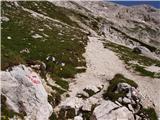 82
82 83
83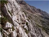 84
84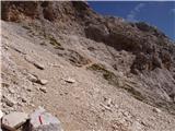 85
85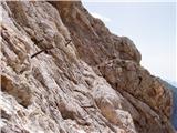 86
86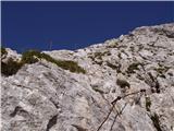 87
87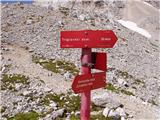 88
88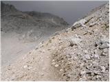 89
89 90
90 91
91 92
92 93
93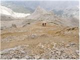 94
94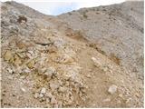 95
95 96
96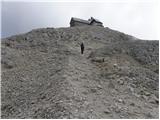 97
97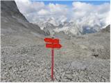 98
98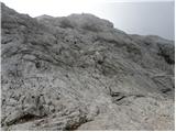 99
99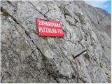 100
100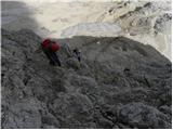 101
101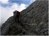 102
102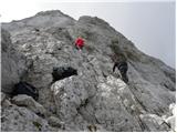 103
103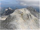 104
104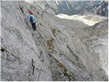 105
105 106
106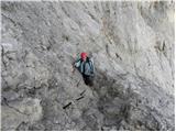 107
107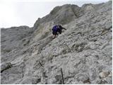 108
108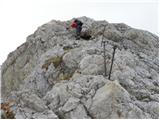 109
109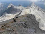 110
110 111
111 112
112 113
113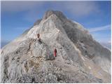 114
114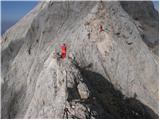 115
115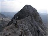 116
116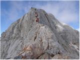 117
117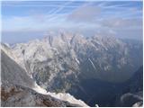 118
118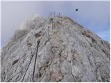 119
119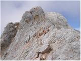 120
120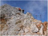 121
121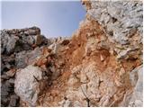 122
122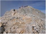 123
123 124
124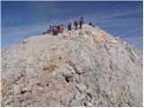 125
125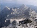 126
126 127
127
Discussion about the trip Rudno polje - Triglav (via Kredarica)
|
| Gost7. 09. 2007 |
This year in July we decided to conquer Triglav via this path. The path is very nice, well-maintained and safe. We recommend it also for families with children.
|
|
|
|
| Gost7. 11. 2007 |
I agree
|
|
|
|
| Nacek8. 03. 2008 |
I agree it is a nice path because I also went along it last year. But whether it is also for children I don't know... The child must not be afraid of heights and precipices. That's about it.
|
|
|
|
| urosl12. 07. 2008 |
Can anyone recommend a three-day hike in the Julian Alps? We'd go the first week of August!
Best regards, Uroš
|
|
|
|
| andrej jerina12. 07. 2008 |
Are you interested in this as a family trip or just for adults? Hint a bit at direction, goals where you want to hike! Options are plenty. LP Andrej
|
|
|
|
| začetnik14. 07. 2008 |
What about a two-day hike via Triglav and the Seven Lakes for a family with 7 and 8 year old children, is there anything suitable? Thanks for help.
|
|
|
|
| Klin14. 07. 2008 |
A very nice tour is start at Planina Blato continuation via Planina pri Jezeru to Triglav Lakes. Second day to Zasavska koča and return via valley za Kopico. If you have enough fitness, first day to Zasavska koča, second day also ascent to Kanjavec.
|
|
|
|
| urosl15. 07. 2008 |
Four adults would go, with quite good fitness!
Since we're doing the Slovenian Mountain Trail, it would be good if we got as many stamps as possible!
Best mountain regards, Uroš
|
|
|
|
| Tadej15. 07. 2008 |
Day 1 From Vrata to Staničev dom (stamp 1) then via Kredarica (stamp 2) to Triglav summit (stamp 3), descent to Dolič and to Prehodavci (stamp 4), overnight there. (approx. 10 hours walking without breaks)
Day 2 From Prehodavci descend to Dvojno jezero (stamp 5) and on to koča pod Bogatinom (stamp 6), continue to Krnska jezera (stamp 7) and ascend to Krn summit, overnight at Gomiščkovo zavetišče (stamp 8). (approx. 10-12 hours)
Day 3 From Krn continue to koča na planini Razor (stamp 9) and from there to Vogel (stamp 10). From Vogel to cable car and then down by cable car to the valley. (approx. 10-12 hours).
|
|
|
|
| Nickster21. 07. 2008 |
In September I'm going up and I can't wait since it's my first time on this route! 
|
|
|
|
| sash8914. 08. 2009 |
I'm wondering if it's possible to climb Triglav independently? There are probably detailed maps to guide you to the top along the path from Rudno polje. Are there affordable overnight stays and where to get information about them? I'm interested in a two-day tour, day 1 to Triglav, day 2 descent past Triglav Lakes.
Thanks for the info! LP
|
|
|
|
| PUHI14. 08. 2009 |
Of course it's possible, the paths are marked, and you wouldn't go on an unknown path without a map anyway. You get maps in every bookstore. Good luck, the path is beautiful.
|
|
|
|
| John14. 08. 2009 |
What a question? With such questions I advise you not to climb Triglav yet in "independent organization", even though there are "detailed maps that help you to the top".
|
|
|
|
| _mitja_29. 08. 2009 |
I have one logistical question. Maybe someone knows if buses still go to Pokljuka, and where to get the timetable. I searched all websites, including Alpetour's, but - nothing.
Thanks for help.
|
|
|
|
| serajko29. 08. 2009 |
Mitja
try alpetur 04 578 04 20, but if I remember correctly there is no sensible connection (maybe it's different this year)
lp
|
|
|
|
| robter30. 08. 2009 |
It will be difficult regarding the bus.
|
|
|
|
| šalovci26. 07. 2012 |
This year I bought a motorhome. When I wanted to go to Triglav from Bohinj with my wife in the summer, I found out that you can't leave a motorhome parked anywhere in Bohinj. It seems some people don't distinguish between parking and camping.
In Bohinjska Bistrica there's a nice campsite Danica, where my wife and I also camped, but leaving it there is still too far. About Zlatorog campsite - gold it is indeed - at astronomical prices.
How about parking at Rudno polje?
|
|
|
|
| turbo26. 07. 2012 |
Regarding motorhome parking, there are major issues in Triglav National Park (source: www.tnp.si )
Is it allowed to park a motorhome at parking lots marked with »P« in TNP, and is overnight parking allowed?
The Triglav National Park Act prohibits parking of motor vehicles, tourist trailers or motor vehicles used for habitation outside designated areas (item 42 of Article 13 of the Triglav National Park Act - Official Gazette RS, No. 52/10).
There are no parking lots in the park area equipped for motorhome parking, overnight stops or servicing. Therefore, the only regulated places in the TNP area where motorhomes can be parked overnight are currently campsites.
The decree on traffic regime for motorhomes and parking regime at motorhome sites, according to our data, among the municipalities in TNP is only held by the Municipality of Bovec
http://www.uradni-list.si/1/content?id=81219
|
|
|
|
| sasajo24. 08. 2013 |
Yesterday I reached the summit.
They also replaced part of the fixed protection on the way.
Good luck to all hikers heading to Triglav
|
|
|
|
| denist10. 01. 2017 |
Could someone perhaps recommend a path to the summit that would be the easiest for a dog? If possible, via Kredarica.
From the pictures, it's hard to judge how high the 'steps' are.
Please, don't reply if you are hikers who don't like dogs
|
|
|
|
| subaru10. 01. 2017 |
Given the current conditions on the path Kredarica - Triglav and your intention to drag a dog up there, I think you are the first one who doesn't like dogs.
|
|
|
|
| ljubitelj gora10. 01. 2017 |
In summer via Planika, Mali Triglav, but preferably without a dog.
|
|
|
|
| grega_z_brega10. 01. 2017 |
Seriously... leave the dog at home in the warm.
My dog hides when he sees me with a backpack.
|
|
|
|
| redbull11. 01. 2017 |
Now it's too risky that he wouldn't slip. Better wait until March, when the ground will firm up a bit and better footprints.
Good luck
|
|
|
|
| denist11. 01. 2017 |
I had warm days in mind and not in winter anyway, I'm only interested in the last ascent, so I ask.
|
|
|
|
| denist11. 01. 2017 |
correcting myself, anyway I'll go check it out alone, because I see that on other forums they also criticize dog owners who ask similar things.
thanks for the above answers 
|
|
|
|
| Daaam11. 01. 2017 |
You'll probably have to train the dog a bit. Don't take him first time on the rocks to Triglav. Take him somewhere else before. Just like with people, it applies to dogs too, that you increase the difficulty. Definitely test him on less crowded paths.
|
|
|
|
| denist11. 01. 2017 |
@Daaam
almost daily we hike 1700m, several times already combined routes of multiple peaks and up to 30km together - no problem
experience is not lacking only on Triglav we haven't really gone yet..
best regards
|
|
|
|
| Daaam11. 01. 2017 |
OK condition he has.. but what about movement in a very demanding environment? You didn't write anything about that. ..
|
|
|
|
| grega_z_brega11. 01. 2017 |
But don't take a dog on a leash on exposed sections.
About 10, 12 years ago, a girl was pulled into a precipice by her dog in Repov kot. Apparently, she was building stamina and experience for Triglav.
|
|
|
|
| redbull12. 01. 2017 |
Given the statement that they've only not been to Triglav together yet, then it won't be a problem, especially since they've already hiked Jalovec, Mangart and some mountain above Martuljek.
|
|
|
|
| BOSTJAN3425. 09. 2025 10:40:50 |
I'm interested if anyone has data on the length of the path from Rudno polje past Planika to Triglav and descent via Kredarica?
|
|
|
|
| DVas25. 09. 2025 10:54:11 |
Approx. 26 km and 2150 m elevation gain.
|
|
|
To post a comment you must log in:
If you do not yet have a username, you must first
register.