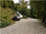
Starting point: Rutarski gozd (1030 m)
| Latitude/Longitude: | 46,21560°N 13,88950°E |
| |
Walking time: 2 h 30 min
Difficulty: easy marked way
Elevation gain: 936 m
Elevation difference along the route: 936 m
Map: TNP 1:50.000
Recommended equipment (summer):
Recommended equipment (winter): ice axe, crampons
Views: 75.109
 | 5 people like this post |
Access to starting point:
From Podbrdo we drive towards Tolmin or vice versa, but only to the village of Koritnica. In Koritnica we will notice a sign for the village Rut, which directs us right (from Tolmin sharply left). We then follow the mostly ascending road to the mentioned village, where there is also a smaller crossroads. We continue straight (left village Grunt) on the road which soon loses its asphalt covering. The wide macadam road quickly ascends above the village and turns right. Three hairpin turns follow, at the third or second left a marked path from Stržišče joins us from the right, and from here onwards we pay attention to possible parking along the road, because driving from the next crossroads onwards is forbidden.
Route description:
From the parking lot we continue on the macadam road, then quickly arrive at an unmarked intersection, where we continue on the upper right road, beside which there is a barrier and a traffic sign that prohibits further driving. Further on we ascend steeply on the increasingly poor road which slowly turns into a wide mostly rocky cart track, passing a hunting observatory and soon bringing us to a junction, where we continue right in the direction of Rodica (straight to mountain pasture Razor). Further we ascend on a relatively well-preserved mule track, first through the forest, then through dwarf pines. Moderately steep and increasingly scenic path, then crosses a few gullies and gets closer and closer to the summit (Jehlc), which we have been seeing in front of us for some time. When the path gets very close to the aforementioned summit, it turns right and then ascends the southern slopes of Rodica. Higher up the path turns west again and brings us to a side ridge of the Lower Bohinj Mountains, from where a nice view opens towards Kneške Ravne. The path soon leaves the ridge for the southern slopes, which we then follow to the point where we join the path from the Bohinj side. We continue right on the panoramic ridge path, which brings us to the panoramic summit in a good 10 minutes of further walking.

Photos:
 1
1 2
2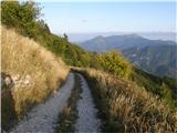 3
3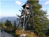 4
4 5
5 6
6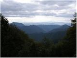 7
7 8
8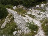 9
9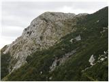 10
10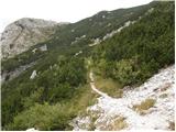 11
11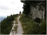 12
12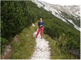 13
13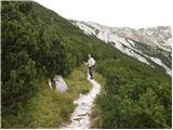 14
14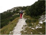 15
15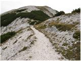 16
16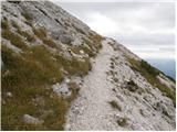 17
17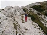 18
18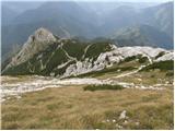 19
19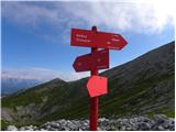 20
20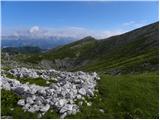 21
21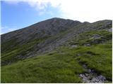 22
22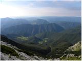 23
23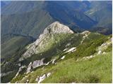 24
24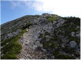 25
25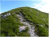 26
26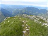 27
27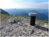 28
28 29
29
Discussion about the trip Rutarski gozd - Rodica
|
| Tadej29. 09. 2008 |
Easy path suitable for a family trip. If you have some time left, I recommend extending the trip to the nearby Jehlc which takes less than 1 hour (both ways).
|
|
|
|
| EUGEN10. 09. 2009 |
With dog Tayo to the summit, extended to mali Raskovec, Raskovec, malo Rodica. Nice trip.
|
|
|
|
| pima5. 08. 2010 |
Is it possible that from this starting point there is also a marked circular path to Rodica-Črna prst-Kal and back to the parking lot?
|
|
|
|
| m.marmota5. 08. 2010 |
Yes, there is, a very nice path, but also long. You can see my report here with the difference that we started in Stržišče.
|
|
|
|
| Okmodko23. 02. 2011 |
From the village Grant it's POORLY marked.
|
|
|
|
| starakapa13. 05. 2011 |
Yesterday my colleague and I were on Rodica. No snow anywhere on the path. Now they have put up a RAMP on the road so the path is extended by cca. 20 minutes. Weather nice sunny only on top windy. Nice view from top on both sides. Snow melting like crazy. All paths in this part of Julijcev passable. On the path we ran into a VIPER
|
|
|
|
| squash25. 06. 2012 |
On 24.6. we did this path and continued to Črna prst. Between Rodica and Črna prst, 2 vipers greeted us. From Črna prst we then descended to Stržišče and continued the path to the beautiful village of Rut. Beautiful day
|
|
|
|
| lubadar6. 01. 2013 |
Today from Ruta to Rodica, in the morning ideal conditions, prepared with full winter gear, but crampons from Veriga Lesce were sufficient
|
|
|
|
| ljubitelj gora9. 06. 2013 |
The ramp is at about 1000 m above sea level. From the village Rut there is an unpaved road and it was in excellent condition on 9.6. You can leave the car a bit above the village Rut and go up the shortcut.
|
|
|
|
| di16. 06. 2013 |
Hiker who lost a bag with items on the path from Rodica on 15. 6. 2013 at 11am can contact d©clovek.si.
|
|
|
|
| ROBERT S10. 12. 2014 |
Today walked the mentioned path, dry all the way up to around 1700 m, from picture 17 onwards (approx. 1800 m) 5 to 15 cm - requires safe steps, the last ascent from the junction (picture 20) on frozen snow that crunched pleasantly :-)), winter gear essential, weather fantastic, just quite unpleasant wind. Couple ahead made the track. Best thanks to them. :-))),
Unforgettable day.
|
|
|
|
| Čeladarka26. 10. 2015 |
Is the path dry? Thanks for the reply and best regards.
|
|
|
|
| babim26. 10. 2015 |
The path to Rodica is dry, snow-free - on Saturday I was at the summit. Unforgettable view, hot along the trail, a bit of wind at the top and possibly some snow patches for a snowball!
|
|
|
|
| mirank2. 12. 2018 |
We started at the barrier and thus extended the path by 10 min, which at such a short approach doesn't matter - 3 vehicles at the old starting point because the barrier isn't closed. Path completely dry to the base of Jehle, and snow patches from there up pose no obstacle. Above 1800m visibility today about 30m; wind and fine ice blasting contributed to a quick return to sheltered spots.
|
|
|
|
| lojz26. 05. 2021 17:17:38 |
Has anyone been up from Ruta recently? Is there snow only on the last ridge or also lower down?
|
|
|
|
| črow27. 05. 2021 08:07:40 |
On the southern side it is snow-free, only in the gullies there is still snow.
|
|
|
|
| lojz27. 05. 2021 09:29:35 |
|
|
|
|
| darinka427. 01. 2022 13:44:02 |
When you get along the gravel road from the barrier to the turn-off for Rodica there's a sign for planina Razor. That's the E7 path that Tolmin markacists were fixing last year. It's quite interesting of course when there's no more snow. On Tuesday it was visible from the top of Rodica trodden further along the ridge.
|
|
|
|
| lojz29. 01. 2022 15:40:38 |
Darinka, do you have more information about E7? Have the Tolminci fixed the path? Namely, this bypass past Huda stopnja was quite tricky.
|
|
|
|
| Milan6129. 01. 2022 16:40:09 |
I hiked the E7 section from Planina Razor to Rutarski gozd last fall, it's fixed and nicely secured where needed. Thanks to the Tolmin markacists.
|
|
|
|
| darinka429. 01. 2022 17:16:47 |
Yes, it really is interesting. Last year we hiked it just when the Tolminci were fixing this path. I remember we talked with them for quite a while. The downside of last year's hike was that there were a lot of mice. Especially from Planina Podkuk. We filled water at the trough. Better not to. Because that's where Marijan most likely caught mouse fever. Renato and I got through fine. I hope there won't be a mouse invasion this year. Because recovery is no fun at all. And in the end you can be glad you have no consequences.
|
|
|
|
| lojz29. 01. 2022 20:23:27 |
Oh, that's great that the path is fixed. Such beautiful and wild areas. A few years ago someone told me that this section would surely be arranged, because the Tolmin markacists take care of it  . .
@Darinka4: uff, that was nasty. And you think the water was the cause?
|
|
|
|
| darinka429. 01. 2022 20:51:12 |
We're just guessing. Maybe just dust from leaves where there was mouse urine. That's because we were just filling water there. And Marijan filled the last one and had bad luck. Yeah, nothing pleasant when high fever just won't go down.
|
|
|
|
| darinka45. 04. 2023 20:26:11 |
We went from Rutarski gozd today. The only hikers. And seven skiers from the direction of Vogla.
|
|
|
|
| cofka5. 04. 2023 22:36:21 |
Darinka, you two are really diligent hikers
|
|
|
|
| daisy666. 04. 2023 06:12:06 |
Darinka4 how is the trail, is there a lot of snow?
|
|
|
|
| darinka46. 04. 2023 09:03:16 |
Cofka thanks. Just set off and go. Daisy66 the trail at least yesterday was fine. Because we used crampons and ice axe only in the last section, in that steep part under the sign and to the top. The snow packs well. And yesterday it was okay for walking. We had trouble only about 1 km to the barrier, because there was a tree, a spruce on the road. Later they removed it. It seems that in the previous days it was quite windy around here, because the hunting stand ended up somewhere below under the trail.
|
|
|
|
| lubadar7. 05. 2023 11:52:22 |
Path passable without winter gear.
|
|
|
|
| darinka414. 03. 2024 18:34:49 |
Today we went on the known path. Weather as forecasted. A bit windy at the top. Otherwise temperatures from 6 to 22 degrees. Everything has already slid down. We needed winter gear. Snow was fine for walking. We met no one.
|
|
|
|
| babica 515. 08. 2024 17:55:50 |
Does anyone have info if this gravel road to the starting point is suitable for a low car (Peugeot)?
|
|
|
|
| mirank15. 08. 2024 19:15:03 |
I was there around May 1st, but the road, although gravel, is almost better than the main road through Baška grapa
|
|
|
|
| darinka427. 12. 2024 20:49:02 |
If anyone might be going to Rodica. We left the car in Rut today because the gravel road to Rutarski gozd was snowy and icy in places. We needed winter gear around 1800 meters. To the top quite icy, but doable. Not much snow. Some wind-packed snow where caution is needed. Didn't meet anyone. Beautiful day. With some wind.
|
|
|
|
| darinka43. 02. 2025 20:03:07 |
Rodica today. Looks like there were many hikers yesterday, as there were many tracks. Views beautiful. With some wind that didn't bother too much. We met no one. At 1700 m altitude we used winter gear.
|
|
|
|
| darinka42. 04. 2025 20:01:30 |
Rodica today 2.4. Quite a lot of snow has accumulated. But we had no problems. Weather as forecasted.
|
|
|
To post a comment you must log in:
If you do not yet have a username, you must first
register.