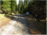
Starting point: Sežanje (1317 m)
| Latitude/Longitude: | 45,57020°N 14,45420°E |
| |
Walking time: 1 h 40 min
Difficulty: easy marked way
Elevation gain: 479 m
Elevation difference along the route: 525 m
Map: Snežnik 1:50.000
Recommended equipment (summer):
Recommended equipment (winter): ice axe, crampons
Views: 23.462
 | 1 person like this post |
Access to starting point:
A) From Cerknica or Nova vas na Blokah, we first drive to Bloška Polica, from there we continue driving in the direction of Lož and Babno Polje. In the settlement Pudob, we turn right in the direction of Snežnik, Ilirska Bistrica, Knežak and the nearby settlement Kozarišče. In Kozarišče, we continue slightly left in the direction of Snežnik and also in the following crossroads we follow the road in the direction of Snežnik. When Kozarišče ends, the asphalt also ends, and we immediately after the bridge over Mali Obrh continue left in the direction of Mašun and Knežak. There follows a relatively long drive on a macadam road, which we follow for approximately 11 km or to Leskova dolina. From Leskova dolina we continue on the main road a little less than 1.5 km or to the spot where signs for Gašperjev hrib 7 km direct us left onto a somewhat steeper road. After more than 5 km of additional driving we arrive at a marked crossroads, where the road branches off to the right towards Gašperjev hrib, and we continue straight on the road which past Meželišče and Vodna draga after additional 5.5 km brings us to a crossroads in Sežanje (on the right side of the crossroads we notice a wooden hut). At the crossroads we continue right, and we follow the road only a short time because it quickly brings us to a sign that prohibits further driving.
B) We drive to Pivka, from there we continue driving towards Knežak. In Knežak at the marked crossroads we continue left in the direction of Mašun and settlements Bač and Koritnice. A little further we go right in the direction of Mašun and Koritnice (straight Bač). After Koritnice the road starts to ascend noticeably, and after 18 km from the main crossroads in Knežak it brings us to Mašun, from where we continue driving right in the direction of Sviščaki. After approximately 2 km of macadam road from Mašun we arrive at a crossroads, where we continue on the left lower road (the right road leads towards Sviščaki), along which we drive approximately another 4 km, or to the crossroads located immediately after the 12 km road sign. At the mentioned crossroads we continue right onto the side forest road (straight to Kozarišče and Leskova dolina), along which we continue approximately 1.3 km, then we join the road from Leskova dolina. There follows less than 4 km of driving, then we arrive at a marked crossroads, where the road branches off to the right towards Gašperjev hrib, and we continue straight on the road which past Meželišče and Vodna draga after additional 5.5 km brings us to a crossroads in Sežanje (on the right side of the crossroads we notice a wooden hut). At the crossroads we continue right, and we follow the road only a short time because it quickly brings us to a sign that prohibits further driving.
C) First we drive to Ilirska Bistrica, then we continue driving towards Sviščaki (the turn-off is in the middle of Ilirska Bistrica and is marked, perhaps a little less noticeable). At first we ascend on an asphalt road, then after less than 12 km of ascent the asphalt changes to macadam. There follows approximately 7 km of macadam, then we arrive at a crossroads in the immediate vicinity of the Planinski dom na Sviščakih mountain hut, where we continue right in the direction of Snežnik. We continue driving on the road along which the marked path to Snežnik also runs, and we drive along it to the marked crossroads below Lom at 1330 m (another 2.5 km). Here we continue right, then after 5.7 km right again. The next crossroads is after 1.7 km, where we continue straight, then after 1.2 km left towards the area named Sežanje. There follows approximately 2.7 km of driving and the road brings us to Sežanje, where at the crossroads by the wooden hut we continue left. Further we drive only a short time, then we come to a sign that prohibits further driving.
Route description:
From the starting point, we continue on the forest road closed to public traffic, which continues through the forest. After a few minutes of easy walking, it starts to descend moderately and brings us into the large grassy hollow Grčovec. Here, where the road almost ends, we continue right and continue the path along the bottom of the valley, where we soon step on an older cart track. Along the cart track we notice some rare blazes, and we soon come to the edge of the forest, where on a rock we notice the inscription Snežnik.
We continue in the direction of Snežnik and continue on an increasingly poor cart track, which soon changes into a poorly trodden but well-marked footpath. Further we ascend through dense forest, then the path brings us into a smaller valley, through which we soon step out of the forest onto slopes overgrown with dwarf pines. The valley through which we ascend becomes ever narrower, the path on which we ascend ever steeper. Higher, the path for a short time rises very steeply through a narrow passage, then gradually widens but still leads us through a smaller valley. The increasingly panoramic path, which runs between dwarf pines, higher flattens and brings us to a junction, where we join the path from Leskova dolina.
We continue in the direction of Snežnik and continue the ascent on the marked path, which brings us from the dwarf pines onto the unvegetated summit slopes of Snežnik. We follow this increasingly panoramic path all the way to the summit, which we reach after a few minutes of further walking.

Along the route: Grčovec (1290m)
Photos:
 1
1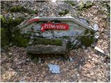 2
2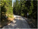 3
3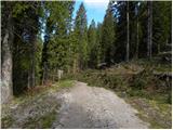 4
4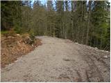 5
5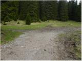 6
6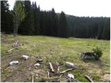 7
7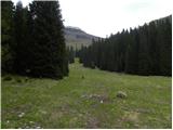 8
8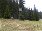 9
9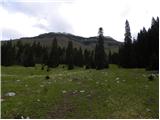 10
10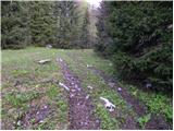 11
11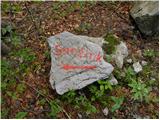 12
12 13
13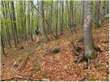 14
14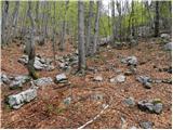 15
15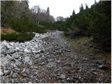 16
16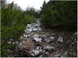 17
17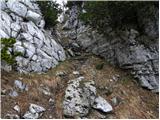 18
18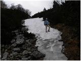 19
19 20
20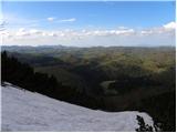 21
21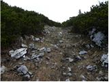 22
22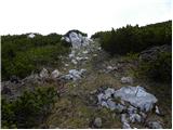 23
23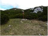 24
24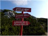 25
25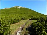 26
26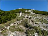 27
27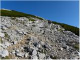 28
28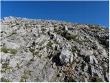 29
29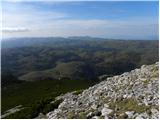 30
30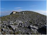 31
31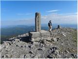 32
32 33
33
Discussion about the trip Sežanje - Snežnik
|
| rs5631. 07. 2011 |
When we reach the grassy valley of Grčovec, we head right towards the hunting observation post. Just before the post, we go left into the hill on a poorly visible trail. No markers across the grassy slope. At the top of the grassy slope, right before the forest, we veer slightly left where we spot markers for Snežnik. These markers are renewed and well followable to Snežnik summit. The steep section from Grčarc to the fork below Snežnik is quite demanding and offers no respite. Walking time 1h 44min
After the strenuous ascent, nice tea warmed us in the hut along with delicious Janja's štruklji
|
|
|
To post a comment you must log in:
If you do not yet have a username, you must first
register.