Solkan - Sabotin (northern way)
Starting point: Solkan (100 m)
| Latitude/Longitude: | 45,97510°N 13,64840°E |
| |
Route name: northern way
Walking time: 2 h
Difficulty: partly demanding marked way
Elevation gain: 509 m
Elevation difference along the route: 509 m
Map: Goriška 1:50.000
Recommended equipment (summer): helmet, lamp
Recommended equipment (winter): helmet, lamp
Views: 69.277
 | 6 people like this post |
Access to starting point:
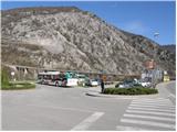
First, we drive to Nova Gorica and then continue driving towards Tolmin. At the end of the village Solkan, we turn left onto a large parking lot, which is located before the Solkan bridge.
From Tolmin we drive towards Nova Gorica, but only to the village Solkan. At the beginning of the village, we turn right and park on a large parking lot, which is located behind the Solkan bridge.
The starting point is on the parking lot at the end of Solkan, to which we can get by city bus from Nova Gorica or Šempeter.
Route description:
From the parking lot, we cross the Solkan bridge and then on its other side we notice signposts for Sabotin (south and north path). For the ascent to Sabotin on the north path, we first descend under the bridge, then walk on the path that runs along the Soča River and the railway upwards. The gentle, or level path, then takes us past HE Solkan and after approximately half an hour of walking from the starting point brings us to the mountain signposts, where we continue left upwards. The path ahead ascends moderately along an old military mule track to a nice viewpoint with a bench. Here the path turns left and after a further few minutes of ascent brings us to a path junction, where we have two options for continuing. We continue right in the direction of Sabotin (left to Sabotin, past the ruins of St. Valentin), on the path that gradually starts to ascend ever more steeply. The increasingly steep path brings us below the cliffs of the summit slope of Sabotin. The path then, with the help of steel cables in a moderate ascent, crosses the steep slope (undemanding) and then ascends to numerous caverns (it is good to have a lamp with you to walk through the tunnels). Before the caverns the path turns left and again with the help of steel cables ascends the steps. A steep ascent through military tunnels follows and the path brings us to the mountain hut Dom na Sabotinu. From the hut, we continue in the direction of the summit and the moderately steep and increasingly panoramic path brings us, after 15 minutes of walking from the hut, to the panoramic summit.

Photos:
 1
1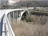 2
2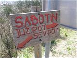 3
3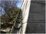 4
4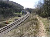 5
5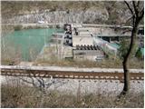 6
6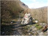 7
7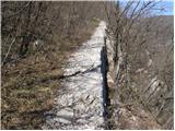 8
8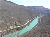 9
9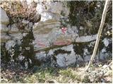 10
10 11
11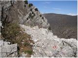 12
12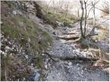 13
13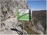 14
14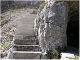 15
15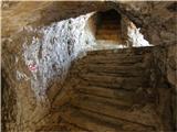 16
16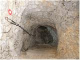 17
17 18
18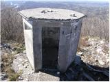 19
19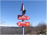 20
20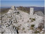 21
21
Discussion about the trip Solkan - Sabotin (northern way)
|
| nofix21. 04. 2009 |
For the starting point of the northern path we can also take the parking area at the Solkan cemetery. We continue 100 m NE on the asphalt path where a view opens to the railway line and further to the Solkan bridge. We cross the bridge without the slightest fear (even if a train surprises us there are side fenced areas on the bridge where we can retreat) and on the other side we join the previously described course of the path.
Secondly, I would like to warn about many adders on Sabotin in the summer months, so then I recommend being a bit louder so there are no surprises.
LP
|
|
|
|
| pier22. 04. 2009 |
Walking on the Solkan railway bridge is strictly prohibited. A bit irresponsible to lure hikers to use this bridge when they can cross the ordinary bridge without any danger.
LP
|
|
|
|
| Enka22. 04. 2009 |
Hello! This northern path interests us, but since we go on outings with our dog, I'm wondering if the path through the tunnels is suitable for a dog (especially if there are no ladders or anything similar)? Thank you very much for the answers!
|
|
|
|
| pier22. 04. 2009 |
No problem in the tunnels, just steep stairs. For the dog it might be a bit harder in the last part before the caverns (short section), where the path is steep and slightly exposed.
Best regards
|
|
|
|
| ksena23. 04. 2009 |
I go to Sabotin often with my dog, who conquers the path without problems. Up the northern and down the southern side, or even up and down the circular path on the northern side. Well, the only problem is sharper stones in certain places that are not friendly to dog paw pads. But still she doesn't resist going up there.
|
|
|
|
| Enka24. 04. 2009 |
Pier and ksena, thanks! I think we'll muster up courage soon because these little pictures are quite tempting  . .
|
|
|
|
| dsusnik23. 04. 2010 |
Really nice and relatively easy path. b/p.
|
|
|
|
| darh27. 04. 2010 |
We descended to the valley via the northern path on Sunday. We were only disturbed by the fresh works on the section between the road bridge and the point where the path descends from the forest, where now instead of the footpath and cart track from the upper pictures a freshly churned up road and construction machinery awaits us. You can read more about our impressions here.
|
|
|
|
| katjuša227. 04. 2010 |
darh-
I saved your blog.
You describe the trails very nicely. And that trail description of the Glinščiče valley I'll try in the near future.
|
|
|
|
| VanSims18. 10. 2010 |
The signpost for southern and northern path is misleading at first glance. So once again:
- for NORTHERN path go UNDER THE BRIDGE
- for SOUTHERN path go straight
|
|
|
|
| Enka22. 02. 2011 |
This is one extremely pleasant trail to an extremely pleasant hill. Just steep enough that at the top you feel you've hiked, just demanding enough (slightly) that it's not boring. And definitely completely suitable for dog friends (pier and ksena, thanks again for the encouragement from two years ago!). Highly recommended!
|
|
|
|
| VanSims11. 04. 2011 |
FOR VISITING THE CAVERNS I recommend a HELMET even more than a flashlight!!! The ceiling is really low and the risk of hitting your head is high. I would have too if I hadn't had a helmet.
The trail is fairly flat at the beginning then steeply ascends, otherwise I'd say it's easy technically.
As for dogs, the cavern and exposure (which isn't that crazy) aren't so problematic yet, more like the scree on the trail for dog paws. We also need to watch that the dog doesn't trigger rocks on those walking below.
|
|
|
|
| Dimitri Tabaj13. 02. 2012 |
Was up there yesterday! -8, wind gusts up to around 150! Soča at the dam between Sabotin and Sveta Gora is frozen over.
|
|
|
|
| Ted29. 08. 2013 |
Ascent along the northern path is in my opinion better than along the southern side.
I must also praise the hut keepers for their friendliness and helpfulness as they allowed me to view the museum even though it was closed.
|
|
|
|
| Maja M.27. 09. 2014 |
Today, 27.9.2014, I left my collapsible hiking poles at the gravel parking lot by the Obcina Brda sign  . Please, finder, contact me. I will be very happy. . Please, finder, contact me. I will be very happy.
|
|
|
|
| dejan6816. 03. 2015 |
One question for Sabotin experts. If there's bora over 100 in Vipava valley, how is it on Sabotin, the same or less? Best, Dejan
|
|
|
|
| SuzanaM16. 03. 2015 |
On the ridge itself it can blow so strongly that it's hard to stay on your feet. How many km/h that is, hard to say. In case of strong wind, you can go on the path that goes right under the ridge on the Italian side. Already just a meter below the ridge on the south side you can walk normally, even if on top it blows to carry away. Tested several times.
|
|
|
|
| dejan6816. 03. 2015 |
Thanks. Just so I know what to expect if strong bora is forecasted for Vipava valley. Otherwise we plan north up and south down. Lp
|
|
|
|
| Majdag9. 04. 2018 |
Thanks for the info Carpinus, very interesting.
|
|
|
|
| Marjas8. 06. 2020 |
Is the path in the northern direction suitable for a 6-year-old child? Is it very exposed? To the extent that there is a risk of slipping?
|
|
|
|
| mirank8. 06. 2020 |
You know your child and his abilities best. This path is wide and safe enough for normally mobile people, there's no talk of exposure, getting into trouble can happen almost anywhere in the world. Just cheerfully on the path
|
|
|
|
| dako8. 06. 2020 |
The northern path starts gently along the Solkan-Plave cycle path, where after two kilometers it branches left onto the mule track. The mule track path ascends moderately to a viewpoint and a bit further a junction where we decide; left-Sv. Valentin and along the ridge to the summit or right-past caverns to the summit. After this junction the path past caverns is quite steep, but with safe walking, unproblematic. If the child is used to hills I think there shouldn't be problems. The easier route in all respects is the southern path.. Best
|
|
|
|
| jax9. 06. 2020 |
The easiest path to Sabotin is the ascent along the northern path to the junction, then along the road to Valentin. This way you reach the ridge on a kind of mulatiera. There really shouldn't be any problems (well, then on the ridge it gets a bit steeper, but really nothing serious).
|
|
|
|
| Ted21. 01. 2023 12:51:56 |
For the lady from Jesenice, the path to Sabotin is normally passable and dry.
Regards, the group from the train
|
|
|
|
| Majdag21. 01. 2023 16:35:28 |
Many thanks, Ted.
|
|
|
To post a comment you must log in:
If you do not yet have a username, you must first
register.