Solkan - Sabotin (southern way)
Starting point: Solkan (100 m)
| Latitude/Longitude: | 45,97510°N 13,64840°E |
| |
Route name: southern way
Walking time: 1 h 30 min
Difficulty: easy marked way
Elevation gain: 509 m
Elevation difference along the route: 509 m
Map: Goriška 1:50.000
Recommended equipment (summer):
Recommended equipment (winter):
Views: 84.022
 | 6 people like this post |
Access to starting point:
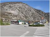
First, we drive to Nova Gorica and then continue driving towards Tolmin. At the end of the village Solkan, we turn left onto a large parking lot, which is located before the Solkan bridge.
From Tolmin we drive towards Nova Gorica, but only to the village Solkan. At the beginning of the village, we turn right and park on a large parking lot, which is located behind the Solkan bridge.
The starting point is located on the parking lot at the end of Solkan, to which we can get by city bus from Nova Gorica or Šempeter.
Route description:
From the parking lot, we cross the Solkan bridge and then on its other side we notice the signposts for Sabotin (south and north path). For the ascent to Sabotin via the "south" path we continue along the edge of the asphalt road, which after a few minutes of ascent brings us to a sharp right turn.
In the middle of the turn, we will notice a signpost for Sabotin, which directs us onto a steep footpath that ascends through a belt of bushes. A little higher, the marked path crosses the road and then on the other side ascends via steep stairs. Ahead the steepness slightly eases and the path, after a few more minutes of walking, brings us to an old military mule track, which we follow only briefly. During the short walk along the mule track, the path brings us to a pleasant "resting place" and viewpoint, after which the path again starts to ascend steeply. Ahead we ascend along a partly rocky path, which occasionally offers nice views of Goriška.
After approximately 1 hour of walking, the path brings us to the main ridge of Sabotin, where we notice the ruins of the church of St. Valentin.
Further, the path slightly descends and through a sparse belt of bushes brings us to the next secondary peak of Sabotin. We continue the ascent along a very panoramic ridge from which beautiful views open up onto the Soča River and Sveta gora. The path, along which we notice numerous remains from the First World War, brings us after an hour and a half to the summit of panoramic Sabotin.
We can extend the trip to the nearby mountain hut and then descend via the "northern" path (during the descent via the northern path, a lamp and helmet are recommended).

Photos:
 1
1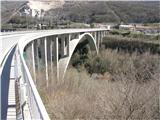 2
2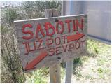 3
3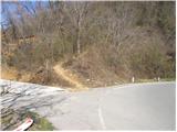 4
4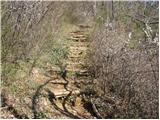 5
5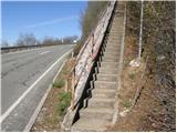 6
6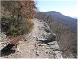 7
7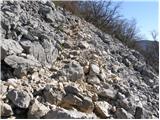 8
8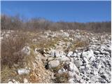 9
9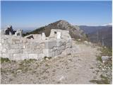 10
10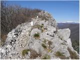 11
11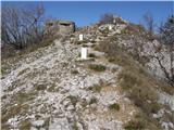 12
12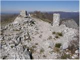 13
13
Discussion about the trip Solkan - Sabotin (southern way)
|
| Gost16. 09. 2007 |
Nice trip, but it's worth extending to the former guardhouse and viewing the caverns. As for the walking time, 1 hour is for fast hikers, for more average ones it takes a good hour and a half
|
|
|
|
| zgonikov8. 10. 2007 |
I've already gone up there a second time, but I'm interested where the stamp is.
Can I get an answer?
Thanks
|
|
|
|
| akvarij17. 01. 2010 |
A bit late reply; the stamp is at the top... (but the top is not where the church ruins are)
Otherwise, the path is a bit poorly marked for those who are there for the first time. For the descent we went past the guardhouse and got a bit lost (female intuition helped)
|
|
|
|
| krsto7120. 11. 2011 |
Today we were up there - ascent via the northern trail, descent via the southern trail...Both trails are quite well marked, the signposts are almost new, so no problems with orientation. The stamp is at the top, specifically halfway between the hut and the church ruins (otherwise it's also in the hut when open). Caution is needed on both trails due to loose rock, the northern trail is quite damp at this time and requires good footwear (especially grip).
Otherwise a wonderful trip with beautiful views and points of interest along the way...
|
|
|
|
| KARAMELICA7. 04. 2013 |
Today we went on this path. Beautiful sunny weather. True, it was windy at the top, but it didn't bother us at all, as we saw the sunshine after a long time. Great, only we didn't find the hut. Apparently it's further from the stamping point. 
|
|
|
|
| jax7. 04. 2013 |
Yes, that's how it is, to the hut you have to go from the top further along the ridge - about 15 minutes. If you go via the northern path, you pass by it.
|
|
|
|
| d1licen7. 04. 2013 |
KARAMELICA, next time also up the northern one.
It takes you directly to the hut.
It also takes you past the excellently restored caverns. They have also nicely equipped that section of the path with a steel cable.
The hut keeper told me today that members of various PDs fixed this just last week. PRAISEWORTHY
|
|
|
|
| KARAMELICA7. 04. 2013 |
Jax and d1licen thanks for both replies. We'll definitely come back, as we couldn't believe the magnificent view of the Soča river from the top. Yes, we also missed the caverns, so you're right, next time via the northern path.
|
|
|
|
| laik7. 04. 2013 |
good evening... so for a beginner (see nickname) you recommend the southern path more? THANKS
|
|
|
|
| Kokta7. 04. 2013 |
Just choose the southern one for the first time. Sabotin is really beautiful, you won't regret it
|
|
|
|
| jax7. 04. 2013 |
Well, I think that for an averagely skilled person (and I don't mean special mountaineering experience) even the circular route (northern up, southern down) shouldn't pose too much of a problem. True, it's a bit steeper up top and goes through that cavern, but it's very nicely made and secured, so you really have nothing to fear.
|
|
|
|
| laik7. 04. 2013 |
Thanks to both.... I'll take the southern path first and save the northern for later.... so, when you go up the southern one, can you also check out the caverns? THANKS
|
|
|
|
| SuzanaM8. 04. 2013 |
I also recommend the circular variant, which doesn't have to be north-south or vice versa. It all depends on how many hours you want to hike and what you want to see. Sabotin is interwoven with numerous paths on both the Slovenian and Italian sides, which also intersect. You can read more about it in the descriptions of the paths Beyond the corridor. Orientation is no problem either, so just boldly put one foot in front of the other.
The southern path is the most crowded and perhaps the most interesting for the first time. For viewing the caverns, inquire at the refreshment point (another 5-10 min walk from the top), where you can also arrange a guided tour lasting about 1 hour.
Otherwise, Sabotin is an extremely interesting and very special hill, so it will enchant you regardless of the path you take.
But don't delay the visit, as the weather forecasters are predicting warming. Usually at this time it's already pleasantly warm here (except this year, when winter just won't leave). For the ascent via the southern path, in about a month it will already be almost too hot (except very early in the morning). For carefree wandering on the numerous trails, it won't be the right time anymore either, as you might disturb a butterfly.
|
|
|
|
| Maja M.27. 09. 2014 |
Today, 27.9.2014, I left my collapsible hiking poles at the gravel parking lot by the Obcina Brda sign  . Please, finder, contact me. I will be very happy. . Please, finder, contact me. I will be very happy.
|
|
|
|
| majasvagelj29. 09. 2014 |
Sabotin - Peace Park ... along the ridge there are boards of natural science and cultural-historical curiosities; path (- I chose: up - southern (past restored ruins of St. Valentine church), down - northern (- both nicely marked)), surroundings, everything - wonderful! One more proof that - nature heals.
P.S. The stamp is at Sabotin summit - next to the box with the logbook. Can also get it at the mountain hut.
|
|
|
|
| ElBombinho22. 09. 2016 |
The crossing over the Solkan - Goriška Brda road in the lower part of the path is unprotected and unmarked. A "zebra" crossing and some sign wouldn't hurt, it's sad that it's not arranged yet.
|
|
|
|
| marinka6714. 08. 2018 |
Yesterday up the southern and down the northern. Since it was Monday, the museum was unfortunately closed, but no problem, everything is on display outside too. After the path, debate on what would be better: up S and down J or vice versa. We'll probably never find out. Or..... let's be surprised. Definitely a mountain worthy of respect! Or..... let's be surprised. Definitely a mountain worthy of respect!
|
|
|
To post a comment you must log in:
If you do not yet have a username, you must first
register.