Sopota - Kum (Nežina pot)
Starting point: Sopota (544 m)
| Latitude/Longitude: | 46,06416°N 15,05664°E |
| |
Route name: Nežina pot
Walking time: 2 h
Difficulty: easy marked way
Elevation gain: 676 m
Elevation difference along the route: 687 m
Map: Posavsko hribovje - zahodni del (PZS)
Recommended equipment (summer):
Recommended equipment (winter):
Views: 47.960
 | 4 people like this post |
Access to starting point:
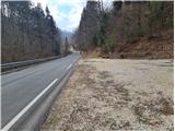
To the settlement of Sopota in the valley of the Sopota River we can arrive via Radeče or via Šmartno pri Litiji. From Šmartno we drive in the direction of Mirna and Gabrovka, paying attention when the road turns left in the direction of Radeče – we follow this road to the settlement of Sopota, where soon beside the road on the left side we notice an arranged parking lot, on which we park. The starting point of the path is approximately 100 m further along the road, where signs for Nežina pot and Kum direct us to the path, at the starting point there is also a large board with the map of the path. From Radeče we drive straight through the center in the direction of the paper mill and Sopota, in the settlement of Sopota on the right we will notice the described starting point and drive another 100 m to the arranged parking lot on the right.
Route description:
At the starting point, we can read the legend about Nežka, Jošt and Jernej on the board with the map, and excerpts from the legend are also written on boards at individual points from the story that we encounter along the path. The signposts for Nežina pot (red signboard) and for Kum (wooden sign), which will show us the way almost to the top, first direct us to the right. Soon before the first house, however, the signpost directs us to the left, where the path ascends across a grassy slope and takes us into the forest. There we continue along the cart track as indicated by the signs, which soon lead us slightly to the left, from the cart track onto a forest path. This takes us to the stream that flows through the forest, and we cross it over a wooden bridge. After the bridge, the path leads more steeply to the left and soon takes us to a wooden fence, and we are already at the first point from the legend, where even today Neža's tears flow from the rock. At this point there is also a cross by the tears of St. Neža. We continue along the path, which ascends through the forest and after a short time takes us to a grassy slope, where we spot the first houses of the village Borovak, which we approach along the right side of the meadow. Just below the first house, the sign directs us left under the house, which we bypass from its left side, and the path then takes us between a few houses to the next point, the filial church of St. Uršula. Above the church, the path joins the road, where we first encounter Knafelc blazes, which we follow to the right. The somewhat less interesting section of the path between Borovak and Mali Kum runs along the road, which we follow in the village of Mali Kum past the tourist farm, after which the signs lead us back into the forest. The path now begins to ascend somewhat more steeply; after a short ascent, which in spring is adorned by snowdrops and crocuses, we reach the rock with the imprints of Neža's knees and the chapel of St. Neža. Above the chapel, the path turns to the right and continues ascending, and when wet it is somewhat slippery on a few steeper sections. The path ascends through the forest towards the right, where at the top we join the path from Radeče and Zidani Most. At the junction, where we continue left along the forest path, there is also the chapel of St. Jošt. After a short, not too steep ascent through the forest, we first spot the transmitter, then also the mountain hut and the church of St. Neža on Kum.
Nežina pot is well marked throughout, with signposts as well as yellow-white blazes. There are no orientation problems. Unlike the paths leading to Kum from Zasavje, this path is shorter, and since it involves overcoming a smaller elevation difference, it is also less demanding. The described condition refers to March 2021.

Along the route: Borovak (707m), Mali Kum (811m)
Photos:
 1
1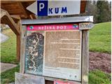 2
2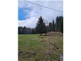 3
3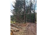 4
4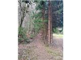 5
5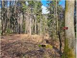 6
6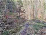 7
7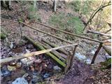 8
8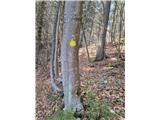 9
9 10
10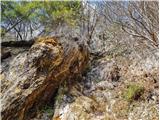 11
11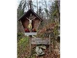 12
12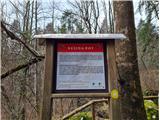 13
13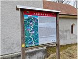 14
14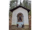 15
15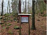 16
16 17
17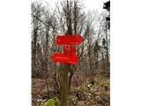 18
18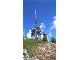 19
19 20
20 21
21
Discussion about the trip Sopota - Kum (Nežina pot)
|
| darkom31. 10. 2021 17:25:59 |
On 31/10/21 I walked the mentioned path.
The path is very well marked, without peculiarities and normally passable.
|
|
|
|
| Savinja112. 10. 2022 19:06:24 |
Today on this path. The path is accurately described, everything matches on the terrain and it's really super marked. It's interesting and at the top the not too strenuous effort is rewarded with really nice views and goodies in the hut. A half-day hiking trip is suitable for everyone. For smaller or younger children, and also for others, we can shorten the hike if we park at smaller parking lots in the hamlets Borovak (at the church of sv. Uršule - 707m) or in Mali Kum (left at the beginning of the hamlet - 812m). It's a peaceful and beautiful rural corner of Slovenia. The path mostly runs through the forest, on asphalt road only between the mentioned hamlets.
|
|
|
|
| Krux1. 11. 2024 17:33:38 |
With a dog that's used to hiking in the mountains, you can nicely reach the top via this path - no special dangers like cliffs etc. There's a village in between with sheep, probably cows on pasture in season too - then definitely tie it up if the dog likes to chase. The path also crosses a narrow courtyard where they have a dog chained. When we passed by, there was no dog, which was quite lucky, otherwise I don't know how we would have bypassed that courtyard.
|
|
|
|
| kofe30. 11. 2025 12:52:17 |
Beautiful path. With a little snow, it's still very pleasant to hike on 30.11. On the MaPZS app GPX track, it deviates from the markings on the grassy slope and leads you through the homestead instead of left. To avoid conflict with the local who blocked the road there, it's better to stick to the road as described here. The signpost is slightly hidden there.
|
|
|
To post a comment you must log in:
If you do not yet have a username, you must first
register.