Spodnja Kokra - Javorov vrh
Starting point: Spodnja Kokra (530 m)
| Latitude/Longitude: | 46,30270°N 14,47540°E |
| |
Walking time: 2 h 20 min
Difficulty: easy marked way
Elevation gain: 904 m
Elevation difference along the route: 904 m
Map: Karavanke - osrednji del 1:50.000
Recommended equipment (summer):
Recommended equipment (winter):
Views: 27.308
 | 4 people like this post |
Access to starting point:
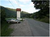
From the Ljubljana - Jesenice motorway take the Kranj - east exit and continue following the road towards Jezersko. Just a few kilometres after the Preddvor turn-off, we will spot a transformer on the right side of the road and a parking lot next to it, where we park. There are also signposts for the Čemšenik hut here.
Route description:
From the parking lot, first carefully cross the road, then head to the footpath towards the Čemšenik hut. The wide path barely rises noticeably to the Polajnar farmstead, where we step onto the road, which we follow to the right.
The road steeply ascends right behind the house, but a little higher it loses the asphalt coating. Further ahead, the road flattens and turns slightly to the left, where it approaches the Čemšeniški stream completely. A bit further on, we cross the mentioned stream and right after it we reach a marked junction, where we continue along the left road towards the Čemšenik hut. The road then begins to ascend more steeply again and after less than 30 minutes of further walking brings us to the Čemšenik hut.
From the Čemšenik hut, continue towards Javorov vrh (signposted Javorjev vrh) along the path that enters the forest after just a few metres. The initially moderately steep path soon leads us to a torrent gully, alongside which it ascends for some time. Higher up, the path turns right and climbs even more steeply. We follow this relatively steep path, which runs through dense forest the whole time, all the way to the junction on the saddle between Potoška gora on the left and Javorov vrh on the right.
Continue right (left to Potoška gora and Sveti Jakob) along the moderately steep path, which after a short ascent brings us to the south-western ridge of Javorov vrh, from which we get some views towards Cjanovci. The path only goes a little further back into the dense forest, where we reach the next well-marked junction.
Here continue slightly right (left to Srednji vrh) along the marked path towards Javorov vrh. The path ahead first ascends moderately, then ever more steeply along the south-western ridge of Javorov vrh. The mentioned path soon brings us to the stamping box, which is located a few steps below the summit.
Starting point - Čemšenik Hut 0:50, Čemšenik Hut - Volčje jame 1:00, Volčje jame - junction below Javorov vrh 0:10, junction below Javorov vrh - Javorov vrh 0:20.

Photos:
 1
1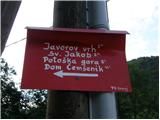 2
2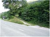 3
3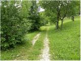 4
4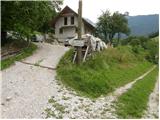 5
5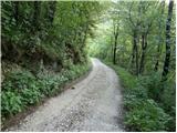 6
6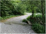 7
7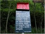 8
8 9
9 10
10 11
11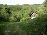 12
12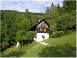 13
13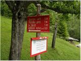 14
14 15
15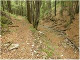 16
16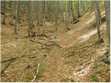 17
17 18
18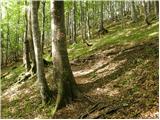 19
19 20
20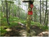 21
21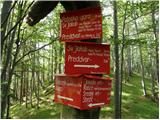 22
22 23
23 24
24 25
25 26
26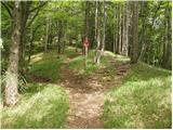 27
27 28
28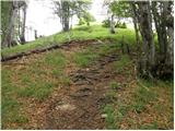 29
29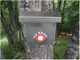 30
30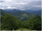 31
31 32
32
Discussion about the trip Spodnja Kokra - Javorov vrh
|
| Gost4. 04. 2007 |
this hike is also suitable for retirees
|
|
|
|
| Gost5. 04. 2007 |
When you are retired, you will be happy if you can get up there. Arrogant.
|
|
|
|
| lubi22. 09. 2008 |
Unripe comment, no doubt. The hike is suitable for everyone who sets out with good spirits and appropriate pace to "conquer" new goals. Don't forget the stop at the Dom na Ćemšeniku, to soothe the soul and stomach with liqueur from pine tips and bite into a delicious fresh donut. For the talkative, a varied debate is guaranteed - the caretaking couple has quite a few "up their sleeves".
Summary - suitable for children, teenagers, young or slightly less young couples (hint for daytime rest), retirees....
Nadka
|
|
|
|
| NEIC00822. 09. 2008 |
Daytime rest??  Where? In the bushes?? Where? In the bushes??
|
|
|
|
| falcon17. 04. 2015 |
Pleasant path. Up via Potoška, down via Jakob.
|
|
|
|
| Branee17. 04. 2015 |
If you went via Potoška you didn't start from Spodnja Kokra (as you're commenting) but from Potok to sv. Jakob and then to Potoška gora and Javorov vrh. Difference if you went there and back
|
|
|
|
| Kranj18. 04. 2015 |
From Turn you go direct to Potoško and back via Jakob!!Circular path
|
|
|
|
| Branee18. 04. 2015 |
From Turn there's nothing there, you have pensioners. From the parking lot at the house you ascend to Jakob then across the road up to Potoško. Even if you don't go to the church it's still Jakob, those few 10m don't make a difference
|
|
|
|
| Gost18. 04. 2015 |
Kranj is right. From the retirees' home, you go towards Jakob, but lower down you turn towards the spring, from there to the right towards the weekend houses on Potoška. If you turn right there, you reach Potoška via Baba; if you turn left, you go past the hunting hut to the top. There you have two options: return to the hunting hut and then to Jakob, or go along the ridge to the saddle, where there is a crossroads of paths to Javorov vrh, Baba, Zaplata, or along the northern side of Potoška to Jakob. LP Miro
|
|
|
|
| Branee18. 04. 2015 |
if you go up via baba it's better to start from spodnja kokra via the čemšenik home I don't see why you would circle around? meanwhile I haven't walked your first variant although I'm born in preddvor. if you go further along the top you reach the junction from spodnja kokra, which also leads to kalisc, of course javor, cjanovca, boršt etc.. I'll go this variant tomorrow, which is not familiar to me (from the spring)
|
|
|
|
| Kranj19. 04. 2015 |
Bravo Miro, one who knows Anyway, Jakob stands on the ridge of Potoška, didn't you know that? safe step
|
|
|
|
| Branee19. 04. 2015 |
And what does that have to do with where something stands.. anyway I run there a lot even though I haven't lived in preddvor for 25 years I do at least 100km of running on the hills there annually (potoče-čanovca sometimes to storžič and back). It's true I haven't gone on the mentioned path. today I'm not going there as I wrote but I'll do it this week already because I'm curious. Is the path older or a new invention? Around jakob there are quite a few new paths which is a pity, especially jakob they've completely ruined..
|
|
|
|
| KARAMELICA19. 04. 2022 14:35:42 |
Yesterday I went along this path. We parked by the main road towards Jezersko (picture 1), then went along the gravel road to the hut at Čemšnik (picture 13) and on to Javorov vrh. On the way back, about halfway, we turned onto the circular panoramic Krems path, which leads back to the mountain hut. Fantastic
|
|
|
|
| Fulcrum16. 02. 2025 13:13:01 |
If you follow the described path, it's good to know that the first markers appear only where the path crosses the stream (photos 7 & 8). Before that, no markers, only the sign at the parking lot (photo 2).
|
|
|
To post a comment you must log in:
If you do not yet have a username, you must first
register.