Spodnje Belopeško jezero - Mala Ponca / Ponza Piccola (on ridge)
Starting point: Spodnje Belopeško jezero (924 m)
| Latitude/Longitude: | 46,48277°N 13,67503°E |
| |
Route name: on ridge
Walking time: 3 h
Difficulty: difficult marked way
Elevation gain: 1001 m
Elevation difference along the route: 1087 m
Map: Julijske Alpe - zahodni del 1:50.000
Recommended equipment (summer): helmet
Recommended equipment (winter): helmet, ice axe, crampons
Views: 2.570
 | 2 people like this post |
Access to starting point:
From Kranjska Gora over the border crossing Rateče we drive towards Trbiž / Tarvisio. Soon after the border crossing, a road branches off to the left towards the Belopeška lakes / Laghi di Fusine, which we then follow in a moderate ascent to the Lower Belopeško Lake. I recommend parking just before the lake, as the starting point of the path is located approximately 100 meters before the lower lake.
Route description:
The marked starting point of the path is located approximately 100 meters before the Lower Belopeško Lake and branches off to the left from the road into the forest. The moderately steep forest path is well marked and mainly leads us along the northern ridge of Mala Ponca. Along the path, there are several beautiful panoramic viewpoints of the Belopeška lakes and surrounding mountains. A few hundred meters before the shelter and the junction, the path flattens, then crosses a gully where ropes and small bridges assist us, before starting to descend gently. When we reach the marked junction at the shelter (located a few tens of meters higher in altitude), we turn sharply left, joining the path from the Upper Belopeško Lake, which passes by the mountain hut Rif. Zacchi.
After a few dozen steps, the path leads us to a torrent stream with a pleasant spring flowing through it. Next follows a short somewhat steeper ascent on a wide stepped path which leads us through larch forest. The path then turns a little to the left and higher brings us to a distinct gully, which descends almost from the peak of Mala Ponca. The marked path here turns right and after further ascent gets completely close to the border ridge. Just a few meters before Škrbina (Vratica), the partially unmarked path (marked only with red dots) turns left and crosses the slopes of the border ridge. The path ahead in a gentle descent crosses a slightly exposed gully, behind which we turn right and then ascend alongside an increasingly steep gully. After a short ascent, the path brings us to the top of the gully between two towers of Mala Ponca. A sign on a rock directs us left onto a steep path, which ascends steeply upwards through dwarf pines. The steep and slightly exposed path brings us to the summit of Mala Ponca in 5 minutes of further walking.

Photos:
 1
1 2
2 3
3 4
4 5
5 6
6 7
7 8
8 9
9 10
10 11
11 12
12 13
13 14
14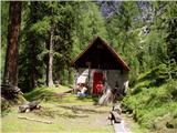 15
15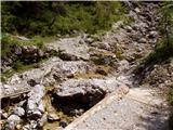 16
16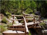 17
17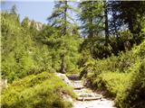 18
18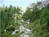 19
19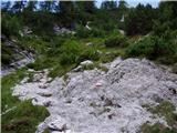 20
20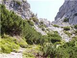 21
21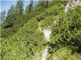 22
22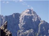 23
23 24
24 25
25 26
26 27
27 28
28 29
29 30
30 31
31
Discussion about the trip Spodnje Belopeško jezero - Mala Ponca / Ponza Piccola (on ridge)
|
| lepenatka25. 08. 2024 12:47:29 |
Apparently this trail is open again.
In the first week of August there was a sign at the beginning of the trail that it was closed.
|
|
|
|
| cybee22. 06. 2025 08:46:16 |
Wonderful path, but unfortunately closed, mainly due to that short passage in the gully. The passage is currently in very poor condition...
|
|
|
|
| mihaoblak25. 06. 2025 17:47:49 |
The path is officially closed. Curiosity won't let go and we go check on 25. 6. 2025. Result: path is normally passable, issue only in the gully (pic 10), where the last little bridge was carried away by a rock. At the wall edge there's a 20cm wide strip allowing very stable footing, wire rope and pegs are practically new (no rust, sealed with two-component mass), middle peg above collapsed bridge into which the wire is clipped wobbles, but its neighbors are 100%. Securing with SVK possible, but not really necessary.
|
|
|
|
| Enka18. 08. 2025 13:48:12 |
On the Locus Map app, a detour is now drawn that path 512 is supposed to take above this "problematic" (closed) section. It seems the path climbs about 50 elevation meters just before the gully and crosses it higher up, then descends back to the normal path right after the closed section. Has anyone checked this up close perhaps?
|
|
|
|
| 2061alessio18. 08. 2025 18:55:50 |
I have, this is a new variant as it replaces the previous secured section, I'll add photos to "current conditions".
|
|
|
To post a comment you must log in:
If you do not yet have a username, you must first
register.