Sporthotel Maltatal - Großer Hafner
Starting point: Sporthotel Maltatal (1933 m)
| Latitude/Longitude: | 47,07890°N 13,34390°E |
| |
Walking time: 4 h 30 min
Difficulty: very difficult marked way
Elevation gain: 1143 m
Elevation difference along the route: 1270 m
Map:
Recommended equipment (summer): helmet, self belay set
Recommended equipment (winter): helmet, self belay set, ice axe, crampons
Views: 43.751
 | 3 people like this post |
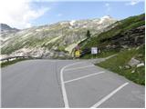
Access to starting point:
From the highway Beljak/Villach - Salzburg, we head to the exit Gmünd and follow the road ahead towards the Maltatal valley. A well-marked road brings us after a few kilometers to the settlement Malta, and only a little further to the spot where toll is paid. The steep and occasionally narrow road, with the help of tunnels and traffic lights, brings us to a large parking lot by the artificial lake (the dam at the end of the lake is 165 m high). While driving, we can observe numerous waterfalls, which, because of a lack of parking spaces, we can view only from the car.
Route description:
From the parking lot by the dam we continue on the road to the signposts at the crossroad. We go right towards the upper parking lot (direction Kattowitzer Hütte). At the upper parking lot then signposts point us to the left on a macadam road on which we are then ascending. After a few turns the road ends, and we continue on a footpath which in gentle descents and ascents crosses slopes towards the southeast. On the path we cross also a few streams and after approximately one hour of walking from the starting point, the path turns slightly to the left through a meadow and crosses a stream. Here the path for the first time starts ascending a little steeper and soon brings us to a crossing. We go right in the direction of Kattowitzer Hütte. Immediately after the signposts follows even a little steeper ascent and we also get help from some ropes, which are not urgently needed. The path brings us to an indistinct saddle and on the right side we will notice the peak Gamsleitenkopf (2346 m) to which we have from the path only a few minutes of walking. From the saddle then follows crossing in a gentle descent all the way to the mountain hut Kattowitzer Hütte.
At the mountain hut, we continue left upwards in the direction of Großer Hafner. The path which ascends over grassy slopes and past smaller streams brings us to a crossroad with signposts. We go left in the direction of Großer Hafner. The right path runs towards the notch Lanischscharte and ahead past lakes Lanischsee. The path from the crossroad then becomes steeper and brings us on the main ridge of the mountain from where a view opens up towards the north. Already after a few meters of walking on the ridge we come again to the signposts. We continue straight on the ridge, while left leads the path past glacier Wastlkarkees and then towards lakes Rotgüldensee. The path then becomes a little more demanding and we also get help from some ropes, which we can use for self-belaying. The demanding part of the path is relatively short; the path on this part leads us on the northern slightly exposed side of the ridge over some smooth rocky slabs and then the path becomes gradually less demanding and brings us on a wide ridge. Here we will notice a specialty of this mountain, namely numerous upright rocks. The majority of the rocks on the mountain are narrow and elongated in shape, and mountaineers who walk past then put them upright. Only a shorter ascent on the wide ridge to the summit follows.

Photos:
 1
1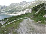 2
2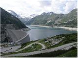 3
3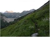 4
4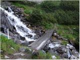 5
5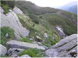 6
6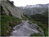 7
7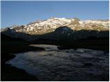 8
8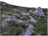 9
9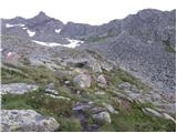 10
10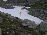 11
11 12
12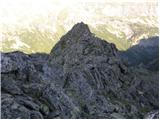 13
13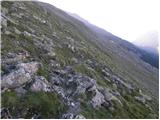 14
14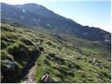 15
15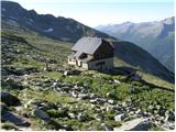 16
16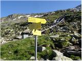 17
17 18
18 19
19 20
20 21
21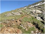 22
22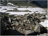 23
23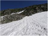 24
24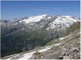 25
25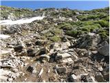 26
26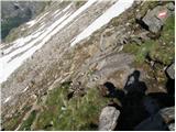 27
27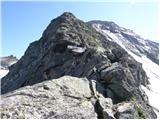 28
28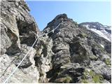 29
29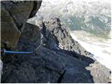 30
30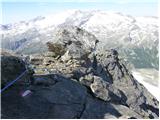 31
31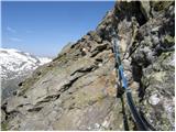 32
32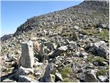 33
33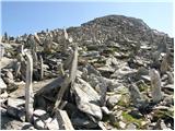 34
34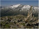 35
35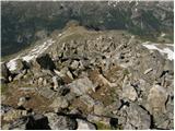 36
36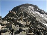 37
37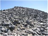 38
38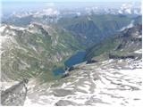 39
39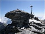 40
40
Discussion about the trip Sporthotel Maltatal - Großer Hafner
|
| velkavrha14. 08. 2009 |
Good hike, which at the start can ascend along the track. Midway a stop at the hut. Nice view of Hochalmspitze and Malte valley.
|
|
|
|
| hribouc14. 08. 2009 |
How long is the drive from Karavanke to the starting point?
|
|
|
|
| velkavrha14. 08. 2009 |
You still have about 1 hour of driving plus a bit from the Karavanke tunnel.
|
|
|
|
| brod2. 09. 2009 |
Yesterday I did the described route. Weather fantastic, water everywhere. Recommend to everyone because the trail is undemanding and suitable for everyone!
|
|
|
|
| velkavrha23. 08. 2010 |
On Sunday I was up there, started at the sign for Kattowitzer hutte (1512m). Weather wonderful.
|
|
|
|
| montura27. 08. 2012 |
The rating "very demanding marked path" in the title of this description is exaggerated; on the ridge the path is indeed somewhat more demanding in places (use of hands for balance when walking over rock blocks, exposure), but the difficulties are moderate and short. Use of a via ferrata set is also not necessary anywhere, as there are no cables, pegs or ladders on the path, only two short ropes which we hold with our hands. Ice axe is welcome in the crumbly steep slope that leads from the hut to the ridge. Otherwise, a magnificent tour with wonderful views and a very friendly hut, not to mention the blueberry plantations 
|
|
|
|
| tutu1. 09. 2012 |
Our group started much before the dam, parking lot about a kilometer below the dam, the path is demanding but not very demanding. Unfortunately we had fog 
I recommend it!
|
|
|
|
| slapan5. 01. 2013 |
Hi.
I plan to travel to the lake along the Maltatal valley. I'm wondering if it's possible to go up with a motorhome, I mean due to height (3.20m), since I read there are also tunnels carved into the rock? Is it even allowed to go up with a motorhome. I'd kindly ask for an answer if anyone knows anything.
|
|
|
|
| turbo5. 01. 2013 |
@slapan,
it'll be fine 
The website says:
....
Beschränkung für Reisebusse: max. 3,85 m Höhe (mit Begleitfahrzeug bis 4,1 m), 14 m Länge...
height matches, and you don't have anything longer than 14m 
Check:
http://www.verbund.com/tm/de/malta-hochalmstrasse
Good luck!
|
|
|
|
| čemšeničan5. 01. 2013 |
Hello! slapan, we happily went on the path years ago with a tourist bus in June. Best regards!
|
|
|
|
| slapan5. 01. 2013 |
Guys thanks for such a quick reply, you really helped me a lot.When I go up there I'll let you know.
Greetings once again.
|
|
|
|
| mini13. 07. 2013 |
Hello, tomorrow we plan to go to Hafner, does anyone know how much snow is left up there??
Thanks and best regards
|
|
|
|
| montura13. 07. 2013 |
Call the Kattowitzer hut at tel. 0043/676/3230100
Enjoy!
|
|
|
|
| main4. 08. 2013 |
The hotel at the water intake is Berghotel Malta and not Sporthotel Maltatal.
|
|
|
|
| robter4. 08. 2013 |
At that time it still was.
|
|
|
|
| Okmodko21. 08. 2013 |
Is the toll paid already before Gmunder hutte or after it? Gmunder hutte is somewhere about halfway up the Maltatal valley.
|
|
|
|
| Buha21. 08. 2013 |
The toll is paid for the last 13-14 km of mountain road and amounts to 18 euros (I was there 2 weeks ago, but I don't know exactly where Gmunder hutte is.
|
|
|
|
| main21. 08. 2013 |
I suspect they collect the toll from 6:00 onwards. We drove past the barrier at 5:50 and there was no one collecting toll.
|
|
|
|
| som6921. 08. 2013 |
I won't claim, but to me it seems they collect it from 7 to 19. In between the traffic light shows red, but for now you can drive past without consequences. The Bohinj people already taught us that with an early hour you also save  . .
|
|
|
|
| VanSims1. 09. 2013 |
TRAIL: I agree too that the 'very difficult' rating is possibly exaggerated. The trail is 'difficult' and nothing more.
To the ridge or to the junction of the trail from Rotgüldensee (the approach to the ridge from that direction is indeed technically more demanding) it's ordinary hiking. From Sporthotel to Kattowitzer hütte it's physically easy (one slightly steeper ascent). From the sign on the road to Kattowitzer hütte, especially from Gmündner hütte it's perhaps steeper (more elevation gain, time roughly the same). From Kattowitzer hütte to the ridge it's physically a bit more demanding
On the ridge we have two fixed ropes (more for protection than progression) and a bit of really easy (I-) climbing, all together no more than 15 min. Then to the summit it's ordinary hiking, somewhat steeper in places. Of course, this applies in good weather without snow, ice,...
What to watch out for (as always on tours) are loose granite rocks and you need to watch the markings a bit, otherwise you can make the route harder for yourself quickly.
ROAD: Toll is collected from 7-18h, 18 EUR, at night it's open (all this August 2013) - so the rule applies: early bird catches the worm. Gmündnerhütte is unfortunately already after the toll. To it from the toll it's about 2h walk but at the start past the beautiful Maltatal waterfalls
|
|
|
|
| ninooos29. 07. 2014 |
Has anyone been up here recently? I'm interested in the snow conditions on the trail?
Thanks, best regards
|
|
|
|
| felix30. 07. 2014 |
At Kattowitzer Hütte they say there's no snow!
|
|
|
|
| gral2. 08. 2014 |
On Friday I was up there and there is definitely no snow.
|
|
|
|
| bačo6. 07. 2015 |
Today we were on the summit in unbearable heat.. wonderful weather at 14 degrees.. at Kattowitzer hütte 23! Toll system still the same....so early.. no more snow on the ridge... below some light snowfields... regarding the difficulty of the tour I would stick with very demanding... that's how the Austrians rate it... with black color... the ridge can be quite awkward if you don't master jumping on granite blocks... those secured spots are good to have and are the least problematic... this year less snow and therefore many loose stones because the snow didn't settle them... recommend the tour ...but surprises me that no one mentions water... we carried it for a whole tank.. but currently there is plenty of water up to 2500 m!.. later when the snow melts you can always get it at the hut lp
|
|
|
|
| felix4. 08. 2015 |
On Saturday we also set out on this trail. Regarding the hiking time, I would rather rely on the times on the signboard, i.e., from the lake to the summit 5 hours. The time estimates published in tour descriptions should take into account average hikers, not personal ones, because those times can be misleading. As for the difficulty, this ascent falls into the demanding trails according to our classification, but by no means among the very demanding ones.
lp.
|
|
|
|
| geppo4. 08. 2015 |
Regarding difficulty, I would add. The path in dry conditions, without fog (fog is common here) is undemanding. But if there is snow (which is common at 3000m even at this time), whether old or new, it's a different story...
Then you need some knowledge, experience and equipment to reach the summit!
lp
|
|
|
|
| Lunca12. 08. 2015 |
We two were at the summit yesterday. There is plenty of water. I also think that the route in current conditions is not very demanding. Caution is definitely not superfluous, as always. Towards Kattowitzer Hütte you can also start a bit lower, there is a junction directly from the road to the hotel. The path from the hotel to the hut drags on quite a bit, lots of descents and ascents, as stated in the description. From the hut onwards the path becomes more varied. Personally, the Ankogel towards the summit was more demanding and also worse marked, but as I wrote, that's just a subjective assessment.
|
|
|
|
| Parkeljc12. 08. 2015 |
Well, the differences in walking times become even more pronounced on longer tours. It drags quite a bit to Kattowitzerhutte, because in just under three hours you gain little elevation. You go up and down quite a bit; after another hour of walking, you look back and see you haven't gained even a meter  , on the contrary , and around every bend you hope to spot it (the hut). But you don't , on the contrary , and around every bend you hope to spot it (the hut). But you don't  . When it first appears from behind the ridge leading to the summit of Großer Hafner, it still takes quite some time to reach it . When it first appears from behind the ridge leading to the summit of Großer Hafner, it still takes quite some time to reach it  . In a short conversation with the hut warden about the weather and polite phrases, I didn't get a feeling of excessive friendliness (subjective). Right after that, he shot out: "Slovenia"? When I nodded, he turned his back and disappeared into the hut . Before that, we had been determined to have something warm to eat in the hut on the way back, but that passed immediately. We treated ourselves to a hot meal after the tour . In a short conversation with the hut warden about the weather and polite phrases, I didn't get a feeling of excessive friendliness (subjective). Right after that, he shot out: "Slovenia"? When I nodded, he turned his back and disappeared into the hut . Before that, we had been determined to have something warm to eat in the hut on the way back, but that passed immediately. We treated ourselves to a hot meal after the tour
Water flows around every corner, and if you're not sensitive, you can drink it. We had it with us, a total of 8 liters. It was good for fitness, but you can get it from nature up to Kattowitzerhutte, and you can get it in the hut for free too. That's what it says on the door!!! Thirst only sets in during the afternoon heat after descending, among the scree.
|
|
|
|
| Janiel7412. 08. 2015 |
I was on this path on Monday, August 10th, and I can only confirm that the path is by no means very difficult in these conditions. Difficult only in that you need to use your hands a bit on the final ridge when you turn right.. As for the warden, I can say he was very friendly and we chatted at length ... he even sat down with me and looked at the Circuit of 60 Peaks of Friendship etc. He also explained all the surrounding peaks and the history of the hut......I happily ate an excellent šmorn in the hut....but our communication was in fluent German
|
|
|
|
| Parkeljc12. 08. 2015 |
We also spoke in "fluent" German. Maybe he just had a bad day or just morning ;-)
|
|
|
|
| haridautovic19. 08. 2018 |
We two visited it on 17.8.2018. We paid 19.5€ for park entry. Starting point at the hotel and dam, towards the Kattowitzer Hütte hut and to the summit. We took less than 4 hours of not fast-paced walking. Yes, I recommend it to everyone who wants to cross the magical 3000-meter line.
|
|
|
|
| ForzaJuve15. 09. 2018 |
Hello,
Has anyone been up there recently? If someone has info on conditions I'd be very glad. Is winter gear needed?
|
|
|
|
| skrba18. 09. 2018 |
I have a plan for 29.9 =)
|
|
|
|
| Bojan_A19. 09. 2018 |
The mountain is snow-free. Winter gear not needed.
|
|
|
|
| ForzaJuve19. 09. 2018 |
Great. Bojan, thanks for the info. I'll head out early Friday morning to start at 5.
|
|
|
|
| ForzaJuve23. 09. 2018 |
On Friday I was at the summit with a colleague. Ideal weather, no clouds, no crowds either. Altogether there were about 10 of us on the mountain all day. To the summit 4 hours of normal walking, as for difficulty, it could easily be marked as difficult. Only about 5 minutes a bit more exposed on the ridge. The way back is a nightmare for the knees, jumping from rock to rock doesn't appeal to me much. I recommend it to everyone, for the first 3-thousander or for a trip to the valley, which is equally beautiful.
|
|
|
|
| enrique26. 09. 2018 |
Hi. Would anyone maybe go up on Friday? Can I join?
|
|
|
|
| UROS126. 09. 2018 |
Not Friday, because I'm working, but one day over the weekend, depending on whether Saturday or Sunday has better weather.
Uroš
|
|
|
|
| ločanka27. 07. 2019 |
On Wednesday on this trail. The trail is by no means very demanding, but requires general caution, as in many places.
I don't know if the same hut keeper is still there, but he greeted nicely in Slovenian, then we spoke in German, which is also in my interest, as whenever there's an opportunity, I like to use it.
Otherwise, the trail is in a very beautiful environment, only the return from the hut back to the lake was a bit too much for me due to countless ups and downs. Perhaps the heat also contributed, as Wednesday was one of the hottest days this year.
|
|
|
|
| J.P.19. 08. 2019 |
We visited the trail on Saturday. It's dry everywhere and not demanding. The start of the trail up to the hut is somewhat less interesting as it's a flat trail with occasional descents and ascents. Personally, I only enjoyed from the hut upwards. For the return, you can avoid the trail to the hut and branch off (already on the ridge) to the western trail, which is secured only with two blue ropes. The trail is not marked and orientation is needed back to the stream and meadow. In any case, I warmly recommend it as the views are simply wonderful.Lp
|
|
|
|
| ločanka19. 08. 2019 |
J.P., good suggestion for the return.
|
|
|
|
| Žigc21. 08. 2019 |
So the via ferrata set is not necessary?
|
|
|
|
| montura28. 08. 2019 |
no, svk is really not needed. celado is nice to have though.
|
|
|
|
| glorija3. 09. 2022 14:44:28 |
The most beautiful and unforgettable well-marked tour over marshy paths that alternate up and down all the way to the descent to the hut, over streams, rocks covered with moss and lichen and waterfalls with wonderful views of the opposite glaciers and starting point at the lake. Friendly hut warden in the hut, onwards over sparkling stones and path strewn with minerals where the steeper ascent begins.
Really no via ferrata kit (helmet recommended) is needed on the ridge, only on the left side of the ridge was the most caution required, as the rocks were already frozen in the shady spot due to temperatures, wind and cold. Obelisks of course, magical! You can't help admiring and photographing these beauties, so the 5h time from start holds true.
Good luck and safe steps in this magical world!
p.s. Yes we were at the starting point before 6h, so entry below via Malt valley to parking didn't need paying, as no one was there yet.
|
|
|
|
| Klinar275. 11. 2024 16:45:06 |
Does anyone know if the road to Sporthotel is currently open to traffic?
|
|
|
To post a comment you must log in:
If you do not yet have a username, you must first
register.