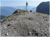
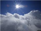
 | Lienzer Dolomitenhütte - Große Gamswiesenspitze (Normalweg)
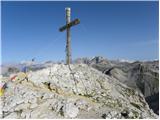
Große Gamswiesenspitze is a 2,488-meter-high mountain located in the heart of the Lienz Dolomites. From the summit, which features a summit logbo...
3 h 30 min |
 | Pecol - Foronon del Buinz / Špik nad Nosom (Ceria Merlone)
Špik nad Nosom is a 2,531 m high mountain located in the ridge between Montaž and Viš. From its rocky summit on a clear day, views open up to the...
3 h 45 min |
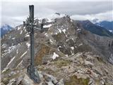
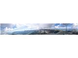
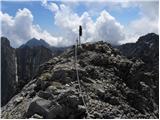
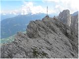
 | Vršič - Prisank / Prisojnik (ridge way)
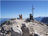
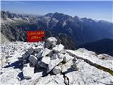
Prisank (also known as Prisojnik) is a 2,547-meter-high mountain situated above the Mlinarica, Krnica, and Suha Pišnica valleys. From the summit,...
3 h 30 min |
| Vršič - Prisank / Prisojnik (Kopiščarjeva pot)
Prisank (also known as Prisojnik) is a 2,547-meter-high mountain situated above the Mlinarica, Krnica, and Suha Pišnica valleys. From the summit,...
3 h 50 min |
| Erjavčeva koča na Vršiču - Prisank / Prisojnik (Kopiščarjeva pot)
Prisank (also known as Prisojnik) is a 2,547-meter-high mountain situated above the Mlinarica, Krnica, and Suha Pišnica valleys. From the summit,...
4 h |
| Erjavčeva koča na Vršiču - Prisank / Prisojnik (ridge path)
Prisank (also known as Prisojnik) is a 2,547-meter-high mountain situated above the Mlinarica, Krnica, and Suha Pišnica valleys. From the summit,...
3 h 45 min |
 | Erjavčeva koča na Vršiču - Prisank / Prisojnik (via Kajzljeva škrbina)
Prisank (also known as Prisojnik) is a 2,547-meter-high mountain situated above the Mlinarica, Krnica, and Suha Pišnica valleys. From the summit,...
5 h |
| Vršič - Prisank / Prisojnik (via Kajzljeva škrbina)
Prisank (also known as Prisojnik) is a 2,547-meter-high mountain situated above the Mlinarica, Krnica, and Suha Pišnica valleys. From the summit,...
4 h 30 min |
 | Maria Waldrast - Lämpermahdspitze (Path over the northern ridge)
Lämpermahdspitze is a somewhat less known mountain located south of the famous and popular Serles. Despite its lower elevation and lesser promine...
3 h 15 min |
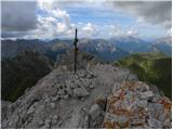
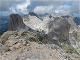
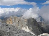
 | Vršič - Razor
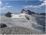
The summit of Razor lies above the alpine valley of Mlinarica. Though not spacious, it offers a superb view. All the peaks above the Kriški podi ...
5 h 30 min |
 | Axamer Lizum - Marchreisenspitze (Lustige Bergler Steig)
Marchreisenspitze is a beautifully shaped and distinctly recognizable mountain and one of the main summits in the Kalkkögel range, the northern b...
3 h 30 min |
 | Colfosco - Sassongher
Cima Sassongher or Sassongher Spitze is a 2665-meter-high mountain that rises steeply above Alta Badia. The mountain is situated in the Puez moun...
3 h 30 min |
 | Türlwandhütte - Hunerkogel
Hunerkogel is a 2,685-meter peak above the Schladming Glacier. From the summit there are beautiful views of the peaks above the glacier, and the ...
4 h |
 | Capanna Alpina - Vallon Bianco
Vallon Bianco (Ladin: Valun Blanch) is a 2,688-meter peak above the Valle di Fanes and Val Travenanzes valleys. From the summit, which has a smal...
4 h 20 min |
| Sant'Uberto - Vallon Bianco
Vallon Bianco (Ladin: Valun Blanch) is a 2,688-meter peak above the Valle di Fanes and Val Travenanzes valleys. From the summit, which has a smal...
5 h 5 min |
| Rifugio Pederü - Vallon Bianco
Vallon Bianco (Ladin: Valun Blanch) is a 2,688-meter peak above the Valle di Fanes and Val Travenanzes valleys. From the summit, which has a smal...
4 h 40 min |
 | Plöckenpass - Creta di Collina / Kollinkofel (path 171)
Creta di Collina (German: Kollinkofel) is a 2,691-meter-high mountain in the Carnic Alps. In the immediate surroundings of the mountain, there ar...
4 h |
 | Plöckenpass - Creta di Collina / Kollinkofel (via Cresta Verde)
Creta di Collina (German: Kollinkofel) is a 2,691-meter-high mountain in the Carnic Alps. In the immediate surroundings of the mountain, there ar...
4 h |
 | Lienzer Dolomitenhütte - Galitzenspitzen
Galitzenspitzen is a 2710-meter-high mountain situated on the ridge between Roter Turm and the highest peak of the Lienz Dolomites, Große Sandspi...
4 h |
 | Alba di Canazei - Colac (path 646)
Colac is a 2715-meter-high mountain located on the western side of the Marmolada mountain group. From the summit, which features a cross, there i...
4 h |
 | Lienzer Dolomitenhütte - Laserzkopf
Laserzkopf is a 2718-meter-high mountain situated near the highest peak of the Lienz Dolomites. From its summit, which has a cross, a nice view o...
3 h 30 min |
 | Türlwandhütte - Kleiner Gjaidstein (via Hunerscharte)
Kleiner Gjaidstein is a 2735-meter-high peak in the Dachstein mountain group. The summit is situated on the ridge between the glaciers Schladming...
4 h 30 min |
 | Prebersee - Roteck
Roteck is a 2742 m high peak located north of Tamsweg in the heart of the Lower Tauern. From the summit, where a cross stands, there is a nice vi...
4 h |
 | Piano Fiscalino / Fischleinboden - Monte Paterno (Ferrata De Luca-Innerkofler)
Monte Paterno is a 2744-meter-high panoramic peak. From the top, there is a breathtaking view in all directions, especially the Tre Cime to the w...
4 h 10 min |
 | Plockenpass - Pilastro del Coglians
Pilastro del Coglians is a 2,750-metre peak east of Monte Coglians on the Austria-Italy border. A summit logbook is located on the compact summit...
4 h 30 min |
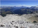
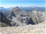
 | Pecol - Jôf di Montasio/Montaž (over Pipan's ladder)
Montaž is one of the most imposing and, at 2,753 m, the second-highest mountain in the Julian Alps. Its authentic Slovenian name is Špik nad Poli...
3 h 30 min |
 | Pecol - Jôf di Montasio/Montaž (via Findenegg couloir)
Montaž is one of the most imposing and, at 2,753 m, the second-highest mountain in the Julian Alps. Its authentic Slovenian name is Špik nad Poli...
3 h 45 min |
 | Plöckenpass - Creta della Chianevate / Kellerspitzen (path 171)
Creta della Chianevate (German: Kellerspitzen) is a 2,769-meter peak in the central Carnic Alps on the AustriaItaly border. From the summit, mark...
4 h 50 min |
| Plöckenpass - Creta della Chianevate / Kellerspitzen (via Cresta Verde)
Creta della Chianevate (German: Kellerspitzen) is a 2,769-meter peak in the central Carnic Alps on the AustriaItaly border. From the summit, mark...
5 h |
 | Lienzer Dolomitenhütte - Große Sandspitze (Ari Schübel)
Große Sandspitze, at 2772 meters, is the highest peak of the Lienz Dolomites. From the summit, which has a summit register box, a breathtaking vi...
3 h 45 min |
 | Pian dei Spiriti - Cima Cadin Nord Est (Via Ferrata Ceria Merlone)
Cima Cadin Nord Est is a 2,788-meter-high peak in the Cadini di Misurina mountain group east of Misurina Pass. From the summit there is a very ni...
3 h 20 min |
 | Capanna Alpina - Furcia Rossa III
Furcia Rossa III is a 2,791-meter-high peak in a somewhat more remote ridge along which the Walk of Peace (Fridensweg / Via della Pace) runs. At ...
4 h 30 min |
| Rifugio Pederü - Furcia Rossa III
Furcia Rossa III is a 2,791-meter-high peak in a somewhat more remote ridge along which the Walk of Peace (Fridensweg / Via della Pace) runs. At ...
4 h 50 min |
| Sant'Uberto - Furcia Rossa III
Furcia Rossa III is a 2,791-meter-high peak in a somewhat more remote ridge along which the Walk of Peace (Fridensweg / Via della Pace) runs. At ...
5 h 15 min |
 | Türlwandhütte - Hoher Gjaidstein (via Hunerscharte)
Hoher Gjaidstein is a 2792-meter-high peak in the Dachstein mountain group. The summit is situated on the ridge between glaciers Schladminger Gle...
5 h |
 | Passo di Costalunga / Karerpass - Cima Latemar / Latemarspitze
Cima Latemar (also Schenon Latemar, German: Latemarspitze) is a 2,800-meter-high peak in the Latemar mountain group. From the summit, where a lar...
3 h 40 min |
| Passo di Costalunga / Karerpass - Cima Latemar / Latemarspitze (via Malga Vallace)
Cima Latemar (also Schenon Latemar, German: Latemarspitze) is a 2,800-meter-high peak in the Latemar mountain group. From the summit, where a lar...
3 h 50 min |
 | Passo di Costalunga / Karerpass - Roda di Vael / Rotwand (Via Ferrata Majare)
Roda di Vael (German: Rotwand) is a 2,806-meter-high mountain in the Catinaccio (Rosengarten) group. The mountain is recognizable mainly by its s...
5 h 30 min |
 | Passo di Costalunga / Karerpass - Roda di Vael / Rotwand (via Passo dal Vaiolon)
Roda di Vael (German: Rotwand) is a 2,806-meter-high mountain in the Catinaccio (Rosengarten) group. The mountain is recognizable mainly by its s...
4 h |
 | Ristorante Pietofana - Cima Formenton (via Rifugio Pomedes)
Cima Formenton is a 2,830-meter-high peak in the Tofana group. The mountain lies north of the better-known Tofana di Dentro, with an unmarked tra...
5 h 5 min |
 | Türlwandhütte - Kleiner Koppenkarstein (via Hunerscharte)
Kleiner Koppenkarstein is a 2,832-meter peak in the Dachstein mountain group. This indistinct summit is located on the Koppenkarstein ridge above...
4 h 15 min |
 | Türlwandhütte - Großer Koppenkarstein (via Hunerscharte)
Großer Koppenkarstein is a 2865-meter-high mountain in the Dachstein mountain group. It is situated above the Schladminger Gletscher glacier. Fro...
4 h 50 min |
 | Zettersfeld - Schleinitz (Klettersteig)
Schleinitz is a 2,905-meter-high peak in the southern part of the Schober mountain group. From the summit there is a very nice view of all the ma...
4 h 30 min |
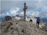
 | Passo Campolongo - Boeseekofel / Piz da Lech
Piz da Lech (German: Boeseekofel) is a 2,911-meter-high peak in the Sella mountain group. From the summit, where there is a cross with a logbook ...
3 h 10 min |
 | Piano Fiscalino / Fischleinboden - Croda Rossa di Sesto (Via Ferrata Croda Rossa)
Croda Rossa di Sesto (German: Sextner Rotwand, also Zehner) is a 2,965-meter-high mountain in the Sexten Dolomites (Dolomiti di Sesto). The mount...
5 h |
 | Rifugio Pederü - Cima Nove / Neunerspitze
The Italian Cima Nove or Sasso delle Nove, German Neuner or Neunerspitze, Ladin Sas dles Nü or Nönör is a 2,968-meter-high peak in the Fanes-Sene...
4 h 50 min |
 | Türlwandhütte - Hoher Dachstein (via Hunerscharte)
Hoher Dachstein is, at 2995 meters, the highest peak of the Dachstein mountain group. The summit is located on the border between the federal sta...
5 h 45 min |
 | Rifugio Gardeccia - Catinaccio d'Antermoia / Kesselkogel
Catinaccio d'Antermoia (German: Kesselkogel, Ladin: Antermoa) is, at 3004 meters, the highest peak and only three-thousander in the Catinaccio (R...
3 h 30 min |
 | Rifugio Gardeccia - Catinaccio d'Antermoia / Kesselkogel (via Passo di Antermoia)
Catinaccio d'Antermoia (German: Kesselkogel, Ladin: Antermoa) is, at 3004 meters, the highest peak and only three-thousander in the Catinaccio (R...
4 h |
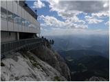
 | Passo Tre Croci - Cristallino d'Ampezzo
Cristallino d'Ampezzo is a 3008-meter-high mountain in the Cristallo group. It is very popular because a cable car reaches almost 3000 meters.Fro...
3 h 40 min |
 | Passo Campolongo - Piz Lech Dlace (Via Ferrata Vallon)
The peak Piz Lech Dlace (German: Eisseespitze, Italian: Piz Lago Gelato) is located above Lake Lech Dlace (German: Eissee, Italian: Lago Gelato) ...
4 h |
| Ossario del Pordoi - Piz Lech Dlace (Via Ferrata Vallon)
The peak Piz Lech Dlace (German: Eisseespitze, Italian: Piz Lago Gelato) is located above Lake Lech Dlace (German: Eissee, Italian: Lago Gelato) ...
4 h 20 min |
 | Alba di Canazei - Cima Ombretta (Via Ferrata Ombretta)
Cima Ombretta is a 3,011-meter-high peak in the Marmolada mountain group. From the summit, where a cross stands, there is the finest view of the ...
5 h 15 min |
 | Rifugio Pederü - Sasso delle Dieci / Zehnerspitze (path 12)
Sasso delle Dieci / Zehnerspitze is a 3,028-meter-high mountain rising steeply above Val Badia valley. Sasso delle Dieci is the highest peak in t...
5 h 30 min |
| Rifugio Pederü - Sasso delle Dieci / Zehnerspitze (path 7)
Sasso delle Dieci / Zehnerspitze is a 3,028-meter-high mountain rising steeply above Val Badia valley. Sasso delle Dieci is the highest peak in t...
5 h 35 min |
| La Crusc - Sasso delle Dieci / Zehnerspitze
Sasso delle Dieci / Zehnerspitze is a 3,028-meter-high mountain rising steeply above Val Badia valley. Sasso delle Dieci is the highest peak in t...
3 h 45 min |
 | La Crusc - Lavarella (via Ju dla Crusc)
Lavarella (also La Varella) is the second-highest peak in the Lavarella group. From the summit, which has a cross, there are excellent views of t...
4 h |
 | La Crusc - Piz dles Conturines
Piz dles Conturines, at 3064 m, is the highest peak in the Lavarella group. From the cross-topped summit, there are fine views of the entire grou...
5 h 30 min |
 | Malga Fosse - Il Nuvolo (Via Ferrata Bolver Lugli)
Il Nuvolo is a 3,075-meter-high peak in the Pale di San Martino mountain group. The mountain is located above the Valle dei Cantoni valley, right...
4 h |
| Malga Fosse - Il Nuvolo
Il Nuvolo is a 3,075-meter-high peak in the Pale di San Martino mountain group. The mountain is located above the Valle dei Cantoni valley, right...
5 h 40 min |
 | Passo Campolongo - Cresta Strenta (Via Ferrata Vallon)
Cresta Strenta is a less prominent peak north of Piz Boè. From the summit there is a superb view over much of the Dolomites. At 3,124 meters, Cre...
4 h 25 min |
| Ossario del Pordoi - Cresta Strenta (Via Ferrata Vallon)
Cresta Strenta is a less prominent peak north of Piz Boè. From the summit there is a superb view over much of the Dolomites. At 3,124 meters, Cre...
4 h 45 min |
 | Passo Campolongo - Piz Boe (Via Ferrata Vallon)
Piz Boe, at 3,152 meters, is the highest peak in the Sella group in the Italian Dolomites. From the summit, there are beautiful views of Marmolad...
4 h 40 min |
| Ossario del Pordoi - Piz Boe (Via Ferrata Vallon)
Piz Boe, at 3,152 meters, is the highest peak in the Sella group in the Italian Dolomites. From the summit, there are beautiful views of Marmolad...
5 h |
 | Malga Fosse - Cima Vezzana (Via Ferrata Bolver Lugli)
Cima di Vezzana is the highest peak in the Pale di San Martino mountain group at 3,192 meters. From the summit there is a very nice view over muc...
4 h 30 min |
 | Seichenbrunn - Glödis
Glödis (or Glödisspitze) is a 3,206-meter-high mountain in the Schober group within Hohe Tauern National Park. The summit, crowned by a large cro...
5 h |
 | Rifugio Dibona - Tofana di Dentro
Tofana di Dentro (also Tofana III or Tofana de Inze) is, at 3,238 meters, the second-highest mountain in the Tofana group. Only the neighboring T...
5 h |
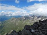
 | Leibnitzbachbrücke - Hochschober (via Staniskascharte)
Hochschober is a 3,240-meter-high mountain in the Schober group. Although it is the fourth highest in the group, the mountain group is named afte...
5 h |
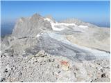
 | Lago di Fedaia - Punta Penia (Marmolada) (Via ferrata Marmolada)
Punta Penia, at 3,343 meters, is the highest peak of Marmolada and the Italian Dolomites. From the summit, where there is a small mountain hut (s...
5 h |
| Lago di Fedaia - Punta Penia (Marmolada)
Punta Penia, at 3,343 meters, is the highest peak of Marmolada and the Italian Dolomites. From the summit, where there is a small mountain hut (s...
4 h |