Axamer Lizum - Marchreisenspitze (Lustige Bergler Steig)
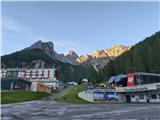
Starting point: Axamer Lizum (1564 m)
| Latitude/Longitude: | 47,19571°N 11,30269°E |
| |
Route name: Lustige Bergler Steig
Walking time: 3 h 30 min
Difficulty: very difficult marked way
Via ferrata: B
Elevation gain: 1056 m
Elevation difference along the route: 1056 m
Map: Innsbruck und Umgebung, 31/5 1:50.000
Recommended equipment (summer): helmet, self belay set
Recommended equipment (winter): helmet, self belay set, ice axe, crampons
Views: 456
 | 5 people like this post |
Access to starting point:
From Ljubljana, we drive on the highway past Salzburg in the direction towards Munich. At the multilevel junction Dreieck Inntal we turn onto the road A93 in the direction of Innsbruck/Kufstein/Brenner. Upon returning to Austria we continue to the junction with the exit Innsbruck-West. There we continue on Egger-Lienz-Straße and turn towards Axams in the direction of Axamer Lizum/Lizum. We continue driving to Axams, where a signpost directs us to a quickly ascending but comfortable asphalt road, which we follow to the free parking lot at the ski area Axamer Lizum. From the center of Innsbruck to Axamer Lizum is approximately half an hour of driving.
Alternatively, driving through northern Italy is offered: in this case from central Slovenia on the highway A2 we drive to one of the border crossings with Austria and continue the journey to Lienz. Here we continue on road 100 and past the crossing Prato alla Drava we drive into Italy. In Italy we follow road SS49 all the way to the junction with highway A22 in the direction towards Brenner Pass. After the pass we continue in the direction towards Innsbruck to the exit Innsbruck-Süd. At the junction we turn onto road B182 and continue driving to Axams. From there we follow the above description.
Route description:
From the parking lot, we go past the center of the ski center Axamer Lizum on the macadam road towards the head of the valley below the rocky peaks of Kalkkögel. Following the signposts for Marchreisenspitze after a few minutes of walking on the road we turn left onto a narrower path which initially crosses the meadow. Soon the path turns right and begins to ascend gently through sparse forest on the southern slope of Schneiderspitze. A little higher the forest thins out, the path horizontally crosses a pasture slope and ascends towards the saddle Halsl, on which there is a junction of numerous paths, among others the alternative path to Marchreisenspitze joins us, which leads to the saddle from Stubai Valley. From the parking lot at Axamer Lizum to the saddle is a little more than an hour of walking.
From Halsl we continue in the direction of Ampferstein and Marchreisenspitze or the path "Lustige Bergler" - the signpost warns that it is suitable only for experienced mountaineers. In the initial part the path moderately steeply ascends in zigzags on the grassy slope of an unnamed elevation in Kalkkögel, but remains technically undemanding. After more than 30 minutes of walking from Halsl we reach a gully that drops deeply towards Axamer Lizum, and along its edge we ascend to the wide ridge of one of the subpeaks of Ampferstein. Continuing, the path leads us easily for some time through panoramic grassy-scree terrain, until after approx. 45 minutes of walking from Halsl we arrive at the foot of the rocky structure of Ampferstein. Before descending into the hollow where the secured part of the path to Ampferstein begins, we cross a slightly exposed passage above the steep gully, then with the help of the first fixed protections on the path (exceptionally some narrow pipes) we descend to the plain in an extremely picturesque environment. From the hollow with the help of a steel cable we ascend along the path that leads across an exposed ledge and continues on a steep slope where fixed protections occasionally help us. A little later the path becomes a continuously secured path, where with the help of a steel cable we ascend over steep rocky jumps. After a short crossing of the corner in the wall of Ampferstein follows an almost vertical ascent over a rocky threshold, where pegs also assist us. After that the steepness eases slightly, and the secured path brings us to the top of the gully below the front of Ampferstein. To the summit of Ampferstein we continue on the path that crosses steep grassy slopes high above Stubai Valley. After approx. 15 minutes of further walking we arrive at the junction right below the summit of Ampferstein, from where to the summit with the traditional large cross it is only a few minutes of ascent.
From the summit of Ampferstein we descend to the junction and continue walking on the path "Lustige Bergler" towards Marchreisenspitze. First we descend to the connecting ridge a few dozen meters lower between Ampferstein and Marchreisenspitze, after which we find ourselves before the key part of the path: a narrow chimney which we climb with the help of a vertically fixed steel cable and pegs that assist us in the demanding crossing. After the chimney we follow a technically less demanding path for some time on the wide panoramic ridge, until the steel cable leads us over a shorter exposed ledge, followed by a descent on crumbly terrain to the foot of the main structure of Marchreisenspitze. From here with occasional help of steel cables we cross locally somewhat airy slopes below the wall of Marchreisenspitze. Soon the path brings us to the exit of a narrow and steep gully, where we head steeply upwards following the mark "Mar". Through the very crumbly gully (as many hikers as are ascending behind us, great caution is needed not to dislodge stones) with the help of a series of steel cables we climb to the point where the path turns sharply right onto the ledge in the wall of Marchreisenspitze. The ledge, from which wonderful views open towards the south, turns over the edge, narrows and exposed crosses the wall of Marchreisenspitze above the precipitous hollow; the path here is well secured with steel cables. After the ledge the path in zigzags continues through a grassy notch that brings us to a rugged and relatively gentle wall, over which with the help of steel cables we ascend to the summit areas of Marchreisenspitze. Here the difficulty and steepness ease, to the summit with the large cross and mighty view we have only a few minutes of easy walking.
Although "Lustige Bergler Steig" is usually presented as part of modern via ferratas, its course and difficulty remind much more of very demanding secured paths in the Slovenian high mountains than of modern sports via ferratas. According to the Austrian scale of secured paths it reaches a relatively modest grade B, nevertheless the use of a via ferrata set is recommended on it, and a helmet due to locally very crumbly terrain in the limestone range is ultimately mandatory. For descent two options are suitable: the demanding marked path which via saddle Malgrubenscharte leads directly towards saddle Widdersberg and to Axamer Lizum, and the longer and somewhat more demanding variant which after Malgrubenscharte ascends to summit Hochtennspitze and descends via a steep gully towards saddle Hoaldl and to the starting point.

Photos:
 1
1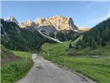 2
2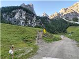 3
3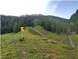 4
4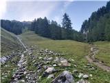 5
5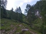 6
6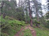 7
7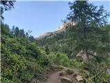 8
8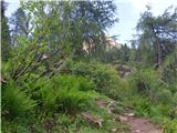 9
9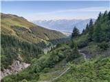 10
10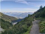 11
11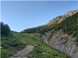 12
12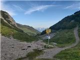 13
13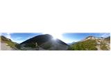 14
14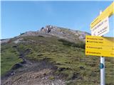 15
15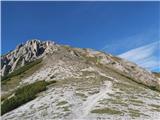 16
16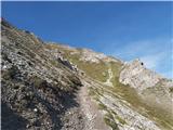 17
17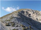 18
18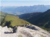 19
19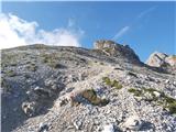 20
20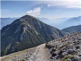 21
21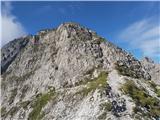 22
22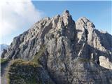 23
23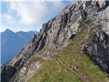 24
24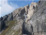 25
25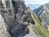 26
26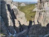 27
27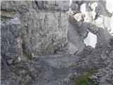 28
28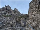 29
29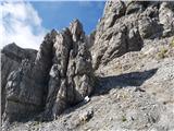 30
30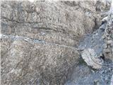 31
31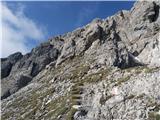 32
32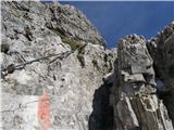 33
33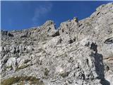 34
34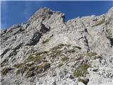 35
35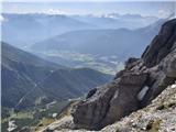 36
36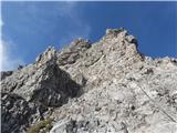 37
37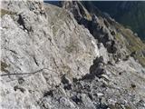 38
38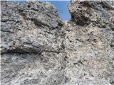 39
39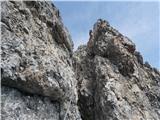 40
40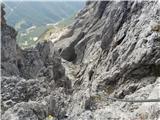 41
41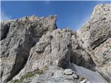 42
42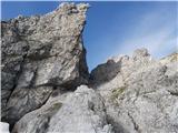 43
43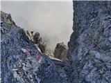 44
44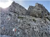 45
45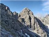 46
46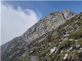 47
47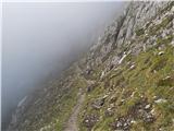 48
48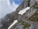 49
49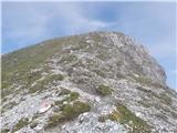 50
50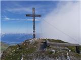 51
51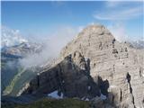 52
52 53
53 54
54 55
55 56
56 57
57 58
58 59
59 60
60 61
61 62
62 63
63 64
64 65
65 66
66 67
67 68
68 69
69 70
70 71
71 72
72 73
73 74
74 75
75 76
76 77
77 78
78 79
79 80
80 81
81 82
82 83
83 84
84 85
85 86
86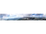 87
87
Discussion about the trip Axamer Lizum - Marchreisenspitze (Lustige Bergler Steig)
To post a comment you must log in:
If you do not yet have a username, you must first
register.