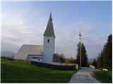
Sveti Janez Krstnik na Ojstrici - Huhnerkogel/Košenjak
Starting point: Sveti Janez Krstnik na Ojstrici (982 m)
| Latitude/Longitude: | 46,61930°N 15,03530°E |
| |
Walking time: 1 h 30 min
Difficulty: easy marked way
Elevation gain: 540 m
Elevation difference along the route: 540 m
Map: Koroška 1:50.000
Recommended equipment (summer):
Recommended equipment (winter):
Views: 38.184
 | 1 person like this post |
Access to starting point:
We drive to the center of Dravograd (to here from Maribor through the Dravska Valley or from Velenje through Slovenj Gradec), where signs for Ojstrica direct us onto the road which after 6.5 km brings us to the church of St. Janez Krstnik on Ojstrica near which we park on the parking lot.
Route description:
From the parking lot at the church, we continue on the asphalt road which quickly brings us to a crossroad by which we notice numerous signposts.
We continue straight in the direction of the mountain hut (sharply right St. Urban) on the road that gently ascends and from grassy slopes passes into a short stretch of forest. The road, which further takes us across panoramic meadows, brings us just a little before the mountain hut to the next crossroad, where we continue sharply right (straight hunting cottage) and in a few further steps arrive at the mentioned hut.
From the mountain hut, we return a few steps back to the information board on which there is a stamping box and a signpost for Košenjak. We continue the ascent in the direction of Košenjak on the path which already after a few further steps of walking enters the forest. The path ahead ascends moderately to steeply through mostly dense forest, which higher brings us to the place where a wider cart track (almost a road) joins.
The mentioned cart track we only cross (left Košenjak gentle path) as the markings direct us onto a wide path which starts to ascend transversely through the spruce forest. Higher the path passes from the forest onto a more extensive clearing at the end of which a path from the chapel of St. Urban joins us from the right and just a little further also the path from Austria. We continue left and follow the gentle path which further runs along the border strip all the way to the top of Košenjak, which we reach after a few further steps of walking.

Photos:
 1
1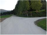 2
2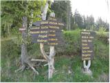 3
3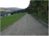 4
4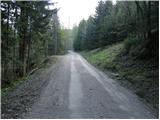 5
5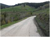 6
6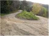 7
7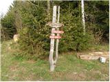 8
8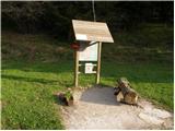 9
9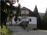 10
10 11
11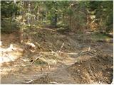 12
12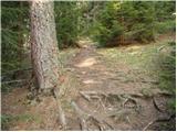 13
13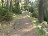 14
14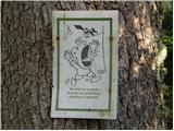 15
15 16
16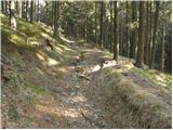 17
17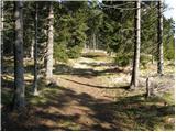 18
18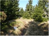 19
19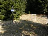 20
20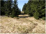 21
21 22
22
Discussion about the trip Sveti Janez Krstnik na Ojstrici - Huhnerkogel/Košenjak
|
| prlekj19. 12. 2009 |
Wow! It was nice! Cold, snowy, so I didn't get to sv. Janez Krstnik by car! But when I arrived at the hut, disappointment again: "HUT IN WINTER OPEN ONLY UPON PRIOR NOTICE"! Cold, snowy, so I didn't get to sv. Janez Krstnik by car! But when I arrived at the hut, disappointment again: "HUT IN WINTER OPEN ONLY UPON PRIOR NOTICE"! Just for those planning to go up in winter! On top -20 plus north wind 30m/s Just for those planning to go up in winter! On top -20 plus north wind 30m/s
|
|
|
|
| Domch27. 01. 2012 |
On Saturday I did a winter tour to Košenjak. Nice path, slippery in places but nothing serious. It would be good to put up another 3 to 4 blazes on the way to the mountain hut (PD Dravograd to action). For this path description it would be best to write that you go straight along the road to the mountain hut and then follow the signs to the summit. There's quite a lot of snow on the summit, a real winter fairy tale.
|
|
|
|
| imori27. 01. 2012 |
PD DRAVOGRAD BETTER THINK ABOUT DISAPPOINTED HIKERS WHO ARRIVE AT THE HUT, BUT THE HUT ON KOŠENJAK IS CLOSED!
|
|
|
|
| Hribovc8827. 01. 2012 |
Who will it be open for during the week unnecessarily For those few souls who go to Košenjak during the week, it's really not worth heating up at home etc... For those few souls who go to Košenjak during the week, it's really not worth heating up at home etc...
|
|
|
|
| imori27. 01. 2012 |
I'm talking about weekends!
|
|
|
|
| Hribovc8827. 01. 2012 |
Well, there aren't that many of us/them even on weekends
|
|
|
|
| Kokta21. 04. 2012 |
Hi everyone... just to mention, from picture 3 onwards to the hut, I only saw two markers. Actually, on that whole section of the path, you hope you haven't missed the trail. From the hut onwards it's great. Yeah, I have to say that in the hut I ate literally the best mushroom soup EVER!. At the top there's a summit book and stamp. Likewise, in the box at the hut you can find the book and hut stamp. One more thing... hut open Fri, Sat and Sun.
|
|
|
|
| Janiel743. 06. 2012 |
Today on this path. Really very nice with beautiful views to the hut and lots of flowers. Steeper after the hut. Plenty of blueberries will be here soon. In short, if it were a bit closer I would go again
|
|
|
|
| imori26. 11. 2012 |
Yesterday on Košenjak, on the circular path from the mountain hut to the summit, back towards Goriški vrh and along the road back to the hut. Nice walk, hut open,...
|
|
|
|
| katja8711. 03. 2013 |
On Sunday 3.3.2013 we set off along this path to the top of Košenjak. We parked at a farm below the village, so we extended the path a bit.
There was about a meter of snow, but no trail was made to the Dom na Košenjaku via shortcuts, so we decided to go along the road instead. From the hut to the top, the trail is well made, so access itself is not difficult. Crampons are therefore not really necessary, but snowshoes are recommended for easier walking.
At the top the sun warmed us nicely. The view of the Kamnik-Savinja Alps was fairy-tale snowy, so we enjoyed an hour at the top
You can see photos from the hike on the website of Planinsko društvo Matica Murska Sobota: http://www.mojalbum.com/pdmaticams/20130303-kosenjak/foto/20578636
|
|
|
|
| Strucko25. 04. 2013 |
Today walked a beautiful path. Very well marked. Nice weather, a little snow on the top.
|
|
|
|
| annuskaananas21. 09. 2014 |
I'm interested in how much walking there is from the hut to the top. Thanks!
|
|
|
|
| marinka6722. 09. 2014 |
Less than an hour, an hour if you're slower.
|
|
|
|
| gregor.cufer28. 02. 2018 |
Today a winter fairy tale. Nice track almost to the top - the last 100 elevation meters now also No stamp to be found at the top
|
|
|
|
| glorija29. 06. 2019 |
Today I walked the path from the chapel of J. Krstnik on Ojstrica to the summit ...Indeed, I didn't find the stamp for the Slovenian mountain trails logbook..not even in the hut, because it was apparently stolen, but the lady in the house under Košenjak is very friendly, I'll return...I must also praise the PD, because from here it's very nicely marked with blazes..Lots of enjoyment to all.
|
|
|
|
| Stamp11. 10. 2019 |
We returned to Sveti Janez, but up we went along trail no. 1 from Iskravcka..
Pictures from this route are on this link..
and gpx track on Wikiloc
|
|
|
|
| Xniinnax8. 01. 2021 |
Hey, does anyone know what the road to the church is like? ☺️
|
|
|
|
| Janezs9. 01. 2021 |
What do you think it will be like? The residents don't move to the valley in winter.
|
|
|
|
| glorija1220. 11. 2021 16:47:53 |
Finally, there's a stamp at the top of Košenjak.
|
|
|
To post a comment you must log in:
If you do not yet have a username, you must first
register.