Suhadolnik - Kamniška koča na Kamniškem sedlu
Starting point: Suhadolnik (901 m)
| Latitude/Longitude: | 46,33520°N 14,51020°E |
| |
Walking time: 8 h 15 min
Difficulty: very difficult marked way
Elevation gain: 963 m
Elevation difference along the route: 1800 m
Map: Kamniške in Savinjske Alpe 1:50.000
Recommended equipment (summer): helmet, self belay set
Recommended equipment (winter): helmet, self belay set, ice axe, crampons
Views: 8.200
 | 4 people like this post |
Access to starting point:
From the Ljubljana - Jesenice motorway, take the Kranj - east exit and follow the road ahead in the direction of Jezersko, but only to the village of Kokra. In the mentioned village, we will notice a few meters before the road crosses the bridge over the Kokra River a road that leads towards Suhadolnik. The road turn-off is located when we are on the right side of the river (left bank), and the road sign is approximately 7 km. We then follow this road to the parking lot, which is located approximately 300 meters before the Suhadolnik farm.
Route description:
At the beginning of the parking lot, we notice hiking signposts, which direct us onto a road, along which in less than 5 minutes of walking we arrive at a smaller crossroads by the Suhadolnik farm. Here we continue along the right road, which we follow for another approximately 5 minutes, or until the point where the blazes lead us onto an ascending cart track. Further on, we ascend the cart track for a short time, then the blazes direct us right onto a footpath that moderately ascends through the forest. Higher up, we return to the cart track, which only a few meters further brings us to a forest road, which we then follow to its end (to here we need approximately half an hour).
At the end of the road, the marked path splits into two parts. We continue along the left path (right somewhat easier "Old path"), which further ascends along a gentle cart track. Somewhat further, the blazes direct us slightly right onto torrent sand deposits, and the path on the other side continues through the forest, where it begins to ascend ever more steeply. Higher, we reach a smaller cavity, and the path behind it becomes technically demanding. With the aid of a steel cable, we ascend one level higher, and the path then continues along a steep slope, where occasionally a peg helps us. Higher, the path turns right, transversely ascends steep and especially in wet slippery-dangerous slopes, and then brings us to an excellently secured passage. With the help of wooden steps or a ladder and the aid of a steel cable, we ascend the steep slope, which without the mentioned protections would be very dangerous. Higher, a few more pegs help us, the path then levels out and crosses a short exposed slope, where an emergency fence aids us. Only a little further, we reach the next ladder, beside which there is no steel cable, but the passage is not particularly demanding. A short descent into a smaller gully follows, and then we cross it too. On the other side of the gully, we steeply ascend (a few staples aid us), then the path gradually levels out and brings us in a few dozen further steps to the place where the somewhat easier "Old path" joins.
A short transverse ascent follows, and the path brings us to a larger plain, where the "old hut" once stood. Through high grass, we walk to the other side of the plain, where we arrive at a marked junction.
We continue straight (left Kočna via Grdi graben) along a moderately steep path, which further ascends through a belt of shrubs. Higher, the path temporarily levels out completely, then brings us among the dwarf pines, where it begins to ascend more steeply. We follow this somewhat steeper path, from which ever better views open up, all the way to Cojzova koča on Kokrsko sedlo.
From the saddle, we continue left towards Grintovec, Kočna, and Skuta. The path steeply ascends immediately above the saddle and a little higher brings us to a junction, where the path to the bivouac below Grintovec and Skuta branches right (straight to Grintovec via Streha and Kočna). We head right onto this initially somewhat less visible pathlet, which in a moderate ascent brings us to the scenic passage over Mala vratca. Behind the narrow passage of Mala vratca, the path begins to descend along a steep and occasionally somewhat exposed slope. At the end of the descent, which takes us about 100 elevation meters, a few pegs aid us. Crossing the gully follows, and then ascent through high-mountain terrain to the bivouac below Grintovec.
Near the bivouac, where there is a junction, we continue right towards Sleme and Turska gora, while left the path leads towards Mlinarsko sedlo and Skuta. The path initially crosses still partly grassy slopes, then brings us onto more scree terrain. The path here is sufficiently well marked so that walking is not orientationally demanding. The path then leads past the summit of Kogel, which we will notice on our right. Further on, there are several short somewhat steeper ascents and descents on the path, which bring us below the slopes of Štruca and Skuta. Along the path on this section there are also a few sinkholes, and from the right an unmarked path joins us, leading over Gamsov skret. When we reach the signpost by the path, the path turns decisively left and begins to ascend more steeply over the scree below the walls of Skuta.
When we approach the wall completely, the path turns right and becomes more demanding. Initially, we cross a steep slope below a rocky overhang, then steeply ascend several times beside the steel cable. The path is secured throughout with a steel cable, and on the shorter section where we cross the gully with pegs. Further in the ascent, we cross steep slopes, and the path brings us to a wider ledge. The scenic path then leads beside a sinkhole in the wall and soon brings us to Sleme, where the path becomes easy again.
The path to Sleme formerly ran somewhat lower, but due to a larger rockfall that occurred in 2003, the path was changed.
From Sleme, where there is a signpost, we continue left and descend along a somewhat steeper slope towards Mali podi. The slope then becomes less steep, and soon left an unmarked shortcut branches off, leading over scree and later joining the path to Skuta. We continue ahead along the marked path, where we occasionally ascend gently. Further on, we walk along the panoramic slopes of Mali podi, where there are also a few sinkholes by the path. By the path, we will then notice a larger cairn where an unmarked path from the bivouac below Skuta joins from the right. To the bivouac from the marked path is approximately 10 minutes of descent.
At the otherwise relatively poorly visible junction, we continue straight, and soon a short somewhat steeper ascent follows, where a few pegs also aid us. The path then becomes leveler again and brings us to a marked junction.
Left upward the marked path to Skuta and Rinke branches off, while we continue straight towards Turska gora. The panoramic path then descends further and brings us to the junction at Vrh Turskega žleba.
Here the path through Turski žleb joins from the left, while we continue slightly right and begin to ascend towards the summit of Turska gora. Initially in a gentle ascent, we cross slopes along the ridge, and occasionally a view opens towards the north, where Mrzla gora stands out. The path then withdraws from the ridge to the right side, and a somewhat steeper ascent towards the summit ridge follows. When we reach the ridge, we continue right and soon reach the summit along the panoramic ridge path. Walking along the ridge when dry presents no major difficulties, but in snow there is a great risk of slipping on the summit ridge.
From the summit, we continue a few meters along the ridge, then the path turns left downward and further descends along the slope on the eastern side of Turska gora. The slope becomes somewhat more grassy for a short time, then the path brings us above a narrow notch. Here the path turns right and steeply descends down the gully. During the descent, a few pegs also aid us. The path then turns left and ascends to a narrow notch. From the notch, a short vertical ascent on staples follows, and then a relatively steep ascent with the aid of a few pegs, which brings us back to a less steep slope. Here we walk for some time mostly along the wide ridge, and the path brings us above the funnel named Sod brez dna.
A more demanding descent through the funnel follows, where we descend almost vertically for a few meters with the aid of steel cables. Below the funnel, a descent along a somewhat crumbly gully follows, then the path turns left and, with the aid of a few protections, crosses a very steep slope. The path brings us to a slightly less demanding slope, from where a view towards the north opens again, with Mrzla gora standing out. Further on, the path becomes demanding again and descends along a steep slope towards the east. Later, the path turns right and crosses an exposed slope secured with pegs, and past the memorial plaque brings us to the ridge above Kotliški graben. Further on, the path briefly crosses a steep slope along the ridge, then descends to the south side of the ridge and descends along a slightly crumbly slope with the aid of a few protections. Later, the path begins to ascend, and a somewhat steeper ascent beside the steel cable follows. The path then turns left and follows a shorter ascent to the Kotliči notch (1949 m).
From the notch, we continue right and then, with the aid of a few protections, in a gentle ascent cross steep slopes on the left northern side of the ridge. The path continues eastwards and brings us below the steep wall on the northwestern side of Brana. Here, from a somewhat cluttered gully, we transversely ascend left upward along a well-secured indistinct groove. The path, secured with a steel cable and a few pegs, then brings us to less steep grassy slopes.
Here the path begins to descend gently again and, crossing scree, brings us to a junction. Right upward the path to Brana branches off, while we continue straight and further cross the slope towards the east. Later, the scree becomes somewhat steeper, and in case of snow, it is also very dangerous. From the scree, we then reach grassy slopes where the path from Okrešelj also joins from the left.
Only a short descent remains along the pleasant grassy slope to the hut on Kamniško sedlo, which we can see ahead for some time.

The trip can be extended to the following destinations: Brana,
Planjava
Photos:
 1
1 2
2 3
3 4
4 5
5 6
6 7
7 8
8 9
9 10
10 11
11 12
12 13
13 14
14 15
15 16
16 17
17 18
18 19
19 20
20 21
21 22
22 23
23 24
24 25
25 26
26 27
27 28
28 29
29 30
30 31
31 32
32 33
33 34
34 35
35 36
36 37
37 38
38 39
39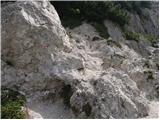 40
40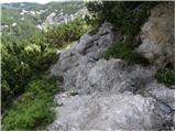 41
41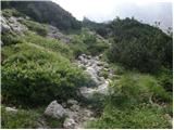 42
42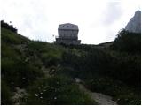 43
43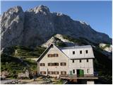 44
44 45
45 46
46 47
47 48
48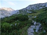 49
49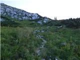 50
50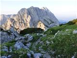 51
51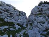 52
52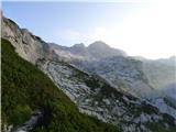 53
53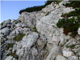 54
54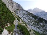 55
55 56
56 57
57 58
58 59
59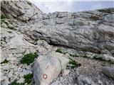 60
60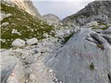 61
61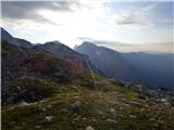 62
62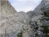 63
63 64
64 65
65 66
66 67
67 68
68 69
69 70
70 71
71 72
72 73
73 74
74 75
75 76
76 77
77 78
78 79
79 80
80 81
81 82
82 83
83 84
84 85
85 86
86 87
87 88
88 89
89 90
90 91
91 92
92 93
93 94
94 95
95 96
96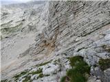 97
97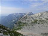 98
98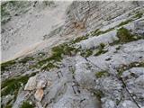 99
99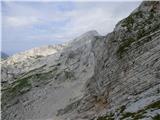 100
100 101
101 102
102 103
103 104
104 105
105 106
106 107
107 108
108 109
109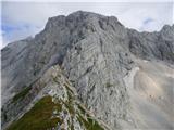 110
110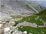 111
111 112
112 113
113 114
114 115
115 116
116 117
117 118
118 119
119 120
120 121
121 122
122 123
123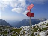 124
124 125
125 126
126 127
127 128
128 129
129 130
130 131
131 132
132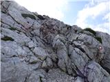 133
133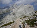 134
134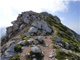 135
135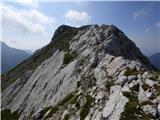 136
136 137
137 138
138 139
139 140
140 141
141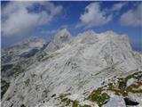 142
142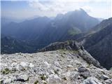 143
143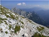 144
144 145
145 146
146 147
147 148
148 149
149 150
150 151
151 152
152 153
153 154
154 155
155 156
156 157
157 158
158 159
159 160
160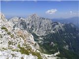 161
161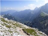 162
162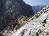 163
163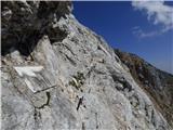 164
164 165
165 166
166 167
167 168
168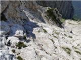 169
169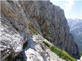 170
170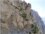 171
171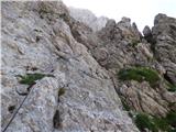 172
172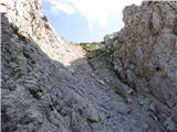 173
173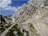 174
174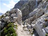 175
175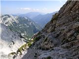 176
176 177
177 178
178 179
179 180
180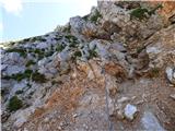 181
181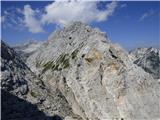 182
182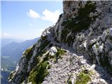 183
183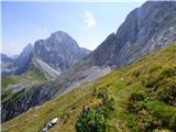 184
184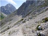 185
185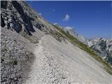 186
186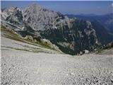 187
187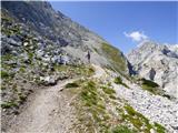 188
188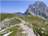 189
189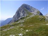 190
190 191
191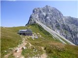 192
192
Discussion about the trip Suhadolnik - Kamniška koča na Kamniškem sedlu
To post a comment you must log in:
If you do not yet have a username, you must first
register.