Suhadolnik - Skuta (via Kokrsko sedlo)
Starting point: Suhadolnik (901 m)
| Latitude/Longitude: | 46,33520°N 14,51020°E |
| |
Route name: via Kokrsko sedlo
Walking time: 5 h 45 min
Difficulty: difficult marked way
Elevation gain: 1631 m
Elevation difference along the route: 1850 m
Map: Kamniške in Savinjske Alpe 1:50.000
Recommended equipment (summer): helmet
Recommended equipment (winter): helmet, ice axe, crampons
Views: 59.168
 | 3 people like this post |
Access to starting point:
From the Ljubljana - Jesenice highway, we take the Kranj - east exit and follow the road ahead in the direction of Jezersko, but only to the village of Kokra. In the mentioned village, a few meters before the road crosses the bridge over the Kokra River, we will notice a road that leads towards Suhadolnik. The road turn-off is located when we are on the right side of the river (left bank), and the road sign is approximately 7 km. We then follow this road to the parking lot, which is located approximately 300 meters before the Suhadolnik farm.
Route description:
At the beginning of the parking lot, we notice hiking signposts, which direct us to a road, along which in less than 5 minutes of walking we arrive at a smaller crossroads at the Suhadolnik farm. Here we continue on the right road, which we follow for approximately another 5 minutes, or to the spot where the blazes lead us onto an ascending cart track. Further on, we ascend briefly along the cart track, then the blazes direct us right onto a footpath that moderately ascends through the forest. Higher up, we return to the cart track, which a few meters further brings us to a forest road, which we then follow to its end (to here we need approximately half an hour).
At the end of the road, the marked path splits into two parts. We continue on the left path (right somewhat easier "Old path"), which further ascends along a gentle cart track. Somewhat further, the blazes direct us slightly right onto torrent deposits of sand, and the path on the other side continues through the forest, where it begins to ascend ever steeper. Higher, we come to a smaller cavity, and the path behind it becomes technically demanding. With the help of a steel cable, we ascend one level higher, and the path then continues along a steep slope, where occasionally some peg helps us. Higher, the path turns right, traverses steeply and especially in wet slippery-dangerous slopes, and brings us to an excellently secured passage. With the help of wooden steps or ladder and help of a steel cable, we ascend the steep slope, which without the mentioned safety gear would be very dangerous. Higher, a few more pegs help us, the path then flattens and crosses a short exposed slope, where an emergency fence helps us. Only a little further we come to the next ladder, next to which there is no steel cable, but the passage is not particularly demanding. Follows a short descent into a smaller gully, which we then also cross. On the other side of the gully, we ascend steeply (helped by some pegs), then the path gradually flattens and in a few dozen steps of further walking brings us to the spot where the somewhat easier "Old path" joins.
Follows a short traversing ascent and the path brings us to a larger plain, where the "old hut" once stood. Through high grass we walk to the other side of the plain, where we arrive at a marked junction.
We continue straight (left Kočna over Grdi graben) along a moderately steep path, which further ascends through a belt of shrubs. Higher, the path temporarily flattens completely, then brings us among the dwarf pines, where it begins to ascend more steeply. This somewhat steeper path, from which increasingly beautiful views open up, we follow all the way to Cojzova koča on Kokrsko sedlo.
From the saddle we continue left in the direction of Grintovec, Kočna and Skuta. The path immediately above the saddle ascends steeply and somewhat higher brings us to a junction, where to the right branches the path to the bivouac under Grintovec and Skuta (straight Grintovec over Streha and Kočna). We head onto this initially somewhat less visible pathlet, which in moderate ascent brings us to the picturesque passage over Mala vratca. Behind the narrow passage of Mala vratca, the path begins to descend along a steep and occasionally somewhat exposed slope. At the end of the descent, which takes us approximately 100 elevation meters, some pegs help us. Follows crossing the gully and then ascent through high-mountain terrain to the bivouac under Grintovec.
From the bivouac we continue along the marked path, which quickly brings us to a junction. We continue straight in the direction of Skuta and Grintovec (right Kamniško sedlo, Rinke and Turska gora) along a relatively gentle path, which soon brings us to the next junction. We continue right in the direction of Skuta (straight Mlinarsko sedlo) along the path that through the karst world of Veliki podi brings us to the foot of a moderately steep wall. Here the path stands vertical and with the help of natural holds we overcome a shorter wall between Dolgi hrbet and Štruca (in wet great slipping danger). At the top of the ascent, the path from Dolgi hrbet joins us from the left. We continue right, where then in a slight descent with the help of some pegs we bypass the summit of Štruca on the left side. The path further brings us to an indistinct little saddle between Štruca and Skuta, from which in 15 minutes along the undemanding summit slope of Skuta we ascend to the summit.
Suhadolnik - Cojzova koča 2:30, Cojzova koča - bivak pod Grintovcem 1:15, bivak pod Grintovcem - Skuta 2:00.

Photos:
 1
1 2
2 3
3 4
4 5
5 6
6 7
7 8
8 9
9 10
10 11
11 12
12 13
13 14
14 15
15 16
16 17
17 18
18 19
19 20
20 21
21 22
22 23
23 24
24 25
25 26
26 27
27 28
28 29
29 30
30 31
31 32
32 33
33 34
34 35
35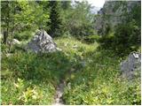 36
36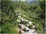 37
37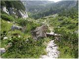 38
38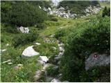 39
39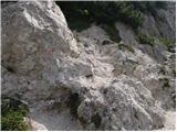 40
40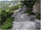 41
41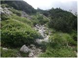 42
42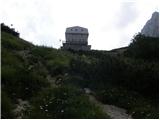 43
43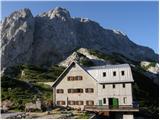 44
44 45
45 46
46 47
47 48
48 49
49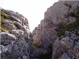 50
50 51
51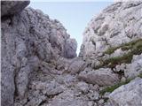 52
52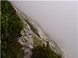 53
53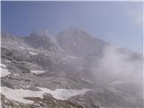 54
54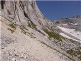 55
55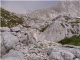 56
56 57
57 58
58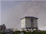 59
59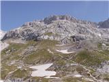 60
60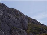 61
61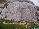 62
62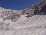 63
63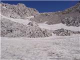 64
64 65
65 66
66 67
67 68
68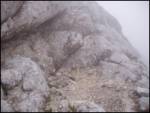 69
69 70
70
Discussion about the trip Suhadolnik - Skuta (via Kokrsko sedlo)
|
| tilenm1. 01. 2009 |
Conditions 31.12.2008: to Mala vrata without problems, then the descent very exposed. We went about 100 m lower earlier, so we crossed under Mala vrata (very steep, risk of slipping), snow soft, sunny side. To Veliki podi and further very tiring terrain due to soft snow base. Then over scree under Štruca to the narrow passage under the wall (picture above). From there onwards for the more daring due to exposed ledge. Half of the 4-member team ended here, 2 made it to Štruca. Further from the mentioned ledge supposedly without problems.
On the way back under Dolge stene directly to Mala vrata, caution needed due to steepness and soft snow.
Crampons recommended on terrain around Mala vrata, otherwise due to nice weather and high temperature that day quite soft base.
Good luck and safe steps in 2009!
|
|
|
|
| NEIC00822. 07. 2010 |
I'm interested in a comparison of the described path from Cojzova koča to Skuta with the path from Češka koča to J. Kočna (Kremžarjeva)?
So, protections, exposure, difficulty..
Thanks
|
|
|
|
| funnyboy22. 07. 2010 |
This trail is easier than Kremžarjeva. There are few exposed sections. Safety features are minimal, or just as many as needed for a trail of this difficulty. Helmet required. Via ferrata kit not necessary. Happy trails.
|
|
|
|
| jvali13. 09. 2011 |
Has anyone hiked this trail in recent days? Can you give me some information? Thanks.
|
|
|
|
| velkavrh14. 09. 2011 |
This described trail is the easiest access to Skuta. Right at the beginning from Suhadolnik, it's better to choose the usual old path, not via Taška, because that path is a bit exposed - also with wire ropes. Then a pleasant path to Zoisova koča and above the hut to the right to the Mala vratca pass and towards the bivouac under Grintavec. Above the bivouac straight ahead, not to the right, next junction to the right, left path to Mlinarsko sedlo. The only slightly more annoying thing is the steep path uphill between Štruca and Skuta. You have to watch the markers so you don't get lost. Otherwise, we can't get completely lost, only risk of slipping on the scree. Special caution is needed here when returning. At the saddle, then to the right to Skuta. I wish you nice weather and great views.
|
|
|
|
| janna14. 09. 2011 |
A few days ago I went on this trail. Where needed, there are wire ropes - in excellent condition, but a bit more caution on the short scree. Beautiful views
|
|
|
|
| jurre15. 03. 2012 |
Has anyone hiked Skuta recently? What are the conditions like? Thanks for the reply.
|
|
|
|
| Domch16. 08. 2012 |
I hiked this very nice tour yesterday. Beautiful and sunny weather, good views and lots of people on all the surrounding peaks. The climbing section towards Štruca is quite interesting - no fixed protections but good holds, great caution is advised on the descent. On the way up, I also visited Štruca. Descent towards Cojzova koča, then I spiced it up with an ascent over Mlinarsko sedlo to Grintovec and down.
|
|
|
|
| Gazela20. 08. 2013 |
This weekend I'm heading to Skuta, so I'm wondering if anyone knows how occupied the bivouac is? Is there a high chance it's occupied? Thanks for any info.
|
|
|
|
| velkavrh21. 08. 2013 |
For our bivouacs in our high mountains you never know if they'll be occupied. Two weeks ago I was here and it wasn't occupied. Higher probability of being occupied in July, lower in August - from my experience and higher that they are occupied in the Julians, less in KSA. But this bivouac is new - in three parts - said colloquially. In the upper two there are bunks - in my opinion for four people each - so enough space. The bivouac is wonderful - I think there's none like it in our mountains. More homely is the one under Kočna, which is also renovated. This one is on the opposite side under Kočna or left of Spodnje Dolce - easily accessible from Zoisova koča via Ovnove čere - we go towards Grintavec to Streha and after about half an hour a path branches left to Dolce, to the bivouac under Kočna and from there to both Kočnas. Walking from the hut to this bivouac is about a good hour. Have a nice day!
|
|
|
|
| Becar21. 08. 2013 |
The bivouac under Grintovec or Pavlet Kemperle's shelter looks really modern on the outside, but inside it feels very cramped to me, as the floor plan square footage is really small. On 18.8.13 I peeked inside a bit (before that 3 Croatians were hanging around the entrance, literally blocking access to the door), the bivouac was not occupied at least until 16:00, later I don't know. What stuck in my memory is the extremely stale air in the bivouac, which in my assessment is a consequence of the instructions that the vent must be closed when leaving. I certainly couldn't fall asleep in such, but that's a matter of individual. Regards
|
|
|
|
| Gazela21. 08. 2013 |
Thanks for the reply. I think I'll take the risk.  I'll report back my opinion. I'll report back my opinion.
|
|
|
|
| matz9. 09. 2013 |
Gazela - how was it in the bivouac under Grintovec? I'm also considering this option...
|
|
|
|
| _sandra_9. 09. 2013 |
the bivouac under Grintovec is super and very nice, if the air is bad, just air it out a bit upon arrival, I mean some Becar comments... if you can't sleep in this bivouac, then it's hard in any other in Slovenia 
|
|
|
|
| Becar9. 09. 2013 |
It's a matter for the individual where they will sleep, I do hikes without bivouacs and huts, so I don't have to deal with the air in bivouacs or any weird bivouac occupiers. I just expressed my opinion, to which I have the right, right? 
|
|
|
|
| Gost9. 09. 2013 |
On Saturday on Dolgi hrbet I spoke with a hiker who spent the night from Friday to Saturday in the bivouac. In the evening three "hikers" from Moravče came with a crate of beer and made a party. Apparently drunkenness is already spreading to bivouacs. Thank God snow will fall soon.
|
|
|
|
| nordkap8. 10. 2014 |
hi,
on Friday I'd go up this path to Skuta, but I'm wondering if there's still snow there as in pictures 63 and 64 at the snowfield crossing, or how it is now, if it's clear or if you can cross without crampons.
Thanks
|
|
|
|
| ravnjak8. 10. 2014 |
Last Saturday there was none, but nice weather those days. If there's any remnant, it ends in a nice pleasant hollow (nothing dangerous - no ice axe needed). No precipice there, just happy trail underfoot and good luck!
|
|
|
|
| nordkap9. 10. 2014 |
okidoki, thnx ravnjak.
Tomorrow I'll tackle Skuta too, then I'm done with Kamnik mountains for this year, actually I've been everywhere, just Skuta missing, which is tomorrow.
Do you maybe know if Cojzova is still open or not.
|
|
|
|
| Hribolazec818. 08. 2024 18:36:52 |
Hello, how is parking in Suhadolnik, parking fee, road?
Thanks
|
|
|
|
| georgia8. 08. 2024 18:40:20 |
As far as I know, there is no road at all and there won't be for some time due to storm damage. Correct me if there's anything new.
|
|
|
|
| Hribolazec818. 08. 2024 18:58:08 |
Georgia thanks, what about the situation in V Koncu, parking fees etc?
|
|
|
|
| kozuc9. 08. 2024 16:59:59 |
The road to Suhadolnik is already fixed, checked last weekend. But I don't know about the trail...
|
|
|
|
| Kaganovich16. 08. 2024 20:22:35 |
The road to Suhadolnik is ok. Over Taško there are some broken steps, otherwise passable, for descent maybe a bit dangerous. The old path has been washed away in several places, the upper part still passable, the lower part is dangerous in one section because you have to climb around a boulder and overall there's a lot of scrambling on rocks. Otherwise from Suhadolnik to the junction everything is destroyed, the trail is trodden everywhere, so people happily march on. Now rain is coming, it might cause more to slip! Careful!
|
|
|
|
| Tine car18. 08. 2024 17:54:11 |
Today in these parts, BE CAREFUL!!!
Obviously the path under PD Kranj maintenance has no notices whatsoever.
|
|
|
|
| garmont18. 08. 2024 18:05:16 |
At the hut on Kokrsko sedlo there is a notice outside that the path to Suhadolnik is closed.
|
|
|
To post a comment you must log in:
If you do not yet have a username, you must first
register.