Sveta Katarina (Zgornja Kapla) - Odomovo Lake
Starting point: Sveta Katarina (Zgornja Kapla) (777 m)
| Latitude/Longitude: | 46,63627°N 15,37496°E |
| |
Walking time: 20 min
Difficulty: easy marked way
Elevation gain: -116 m
Elevation difference along the route: 0 m
Map: Pohorje 1:50.000
Recommended equipment (summer):
Recommended equipment (winter): ice axe, crampons
Views: 388
 | 1 person like this post |
Access to starting point:
A) From the road Maribor - Dravograd we drive almost to the settlement Ožbalt (from the direction Dravograd a little after the settlement). A few hundred meters before (from the direction Dravograd after the settlement) the mentioned settlement a road branches off to the right (from the direction Dravograd left) towards Gradišče and Kapla, and then at the crossroads we follow towards Kapla. We drive along the road to the settlement Zgornja Kapla, where in the center of the settlement, below the church of St. Catherine of Alexandria we park on the parking lot at the cemetery. From the main road to the starting point there is a little less than 15 km.
B) From the road Dravograd - Maribor we drive to the settlement Ožbalt, where at the parish church we turn left (from the direction Maribor right) onto a side road which continues by the branch primary school and then ascends along the Ožbalt stream. Higher at the crossroads we follow in the direction of Kapla, and we drive to the center of the settlement Zgornja Kapla, where below the church of St. Catherine of Alexandria we park on the parking lot at the cemetery. From the main road to the starting point there is a little less than 8 km.
Route description:
From the parking lot, we head onto the road towards Sveta Katarina, then bypass the church on its lower left side. In front of the fire station and past the sports field, we turn left downwards, beginning our descent along a marked path. We quickly reach an asphalt road, continuing our descent, which leads us past a few houses to a marked crossroad at the saddle between the valley of Potočnikov potok on the left and the valley of Črmenica stream on the right.
From the crossroads, we continue slightly left toward Brezno and Odomovo Lake (straight to Austria, right to Gradišče and Ožbalt) and continue descending; after about 5 minutes of further walking, we arrive at Odomovo Lake.
Description and pictures refer to the condition in March 2023.
Photos:
 1
1 2
2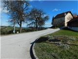 3
3 4
4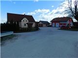 5
5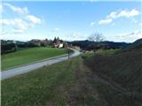 6
6 7
7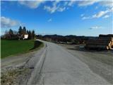 8
8 9
9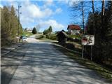 10
10 11
11 12
12 13
13 14
14 15
15 16
16 17
17
Discussion about the trip Sveta Katarina (Zgornja Kapla) - Odomovo Lake
To post a comment you must log in:
If you do not yet have a username, you must first
register.