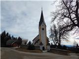
Sveti Urh (Strojna) - Pokeržnikov vrh
Starting point: Sveti Urh (Strojna) (998 m)
| Latitude/Longitude: | 46,59590°N 14,91400°E |
| |
Walking time: 10 min
Difficulty: easy marked way
Elevation gain: 57 m
Elevation difference along the route: 57 m
Map: Koroška 1:50.000
Recommended equipment (summer):
Recommended equipment (winter):
Views: 856
 | 2 people like this post |
Access to starting point:
We drive to Ravne na Koroškem, where at the crossroads near the Petrol petrol station we turn onto the road in the direction of Tolsti Vrh and Strojna. We then follow the road in the direction of Strojna, driving on the ascending road to the church of St. Urh, where we park in a suitable place.
Route description:
From the church, we continue on the road which leads towards the north, from it we go past the sports field, which is situated above the road, left onto a footpath in the direction of Pokeržnikov vrh. We quickly ascend to the sports field, then ascend on a poorer footpath which leads us along the edge of the forest. We follow this path, then with increasingly beautiful views, to the nearby peak, where there is a bench, a panorama board and a logbook box.
Description and pictures refer to the condition in 2019 (February).
Photos:
 1
1 2
2 3
3 4
4 5
5 6
6 7
7 8
8 9
910
11
12
 13
13 14
14
Discussion about the trip Sveti Urh (Strojna) - Pokeržnikov vrh
To post a comment you must log in:
If you do not yet have a username, you must first
register.