Sviščaki - Snežnik (footpath)
Starting point: Sviščaki (1242 m)
| Latitude/Longitude: | 45,57420°N 14,40100°E |
| |
Route name: footpath
Walking time: 2 h
Difficulty: easy marked way
Elevation gain: 554 m
Elevation difference along the route: 600 m
Map: Snežnik 1:50.000
Recommended equipment (summer):
Recommended equipment (winter): ice axe, crampons
Views: 358.463
 | 11 people like this post |
Access to starting point:
A) From Cerknica or Nova vas na Blokah we first drive to Bloška Polica, from there we continue driving in the direction of Lož and Babno Polje. In the settlement Pudob we turn right in the direction of Snežnik, Ilirska Bistrica, Knežak and the nearby settlement Kozarišče. In Kozarišče we continue slightly left in the direction of Snežnik and also in the next crossroads we follow the road in the direction of Snežnik. When Kozarišče ends, the asphalt also ends, and we immediately after the bridge over Mali Obrh continue left in the direction of Mašun and Knežak. There follows a long drive on a macadam road, after which after approximately 19 km from Kozarišče we arrive at a crossroad, where the road from Mašun joins us from the right. Here we continue left in the direction of Sviščaki, to where we have approximately 10 km of macadam, at crossroads we follow the signs for Sviščaki. After approximately 29 km of macadam road we arrive at the Planinski dom na Sviščakih mountain hut, where we park.
B) We drive to Pivka, from there we continue driving towards Knežak. In Knežak at the marked crossroad we continue left in the direction of Mašun and the settlements Bač and Koritnice. A little further we go right in the direction of Mašun and Koritnice (straight Bač). After Koritnice the road starts to ascend more noticeably, then after 18 km from the main crossroad in Knežak it brings us to Mašun, from where we continue driving right in the direction of Sviščaki, to where we have approximately 12 km of macadam road. When we arrive at the Planinski dom na Sviščakih mountain hut we park.
C) First we drive to Ilirska Bistrica, then we continue driving towards Sviščaki (the turn-off is in the middle of Ilirska Bistrica and is marked, perhaps it is only a little less noticeable). At first we ascend on an asphalt road, then after roughly 12 km of ascent asphalt is replaced by macadam. There follows approximately 7 km of macadam, then we arrive at a crossroad in the immediate vicinity of the Planinski dom na Sviščakih mountain hut, where we continue straight towards the nearby mountain hut, where we park.
Route description:
From the parking lot at the Planinski dom na Sviščakih mountain hut we continue on the road that goes across the meadow. On the other side of the meadow we leave the road and ascend the grassy slope in the direction of Snežnik. Already after a few minutes of walking we come back to the road and follow it to a crossroad, where we continue on the left road. The road then after a few dozen steps brings us to the parking lot at the chapel.
Here the signpost for Snežnik directs us onto a cart track that moderately ascends through the forest. After 15 minutes the cart track slightly descends and crosses a forest road. On the other side of the road it starts ascending again, then the steepness eases. The cart track then past a cross brings us to a forest road, where there is a junction.
We continue on the poorer road in the direction of Snežnik, which after 15 minutes brings us to the place where the road ends. Here a nice view opens towards the summit of Snežnik. The signpost then directs us onto a nice path that ascends among dwarf pines in a traverse below Mali Snežnik. The increasingly panoramic path brings us to the ridge, where the path to Mali Snežnik branches off to the left. We continue right and in ten minutes we reach the shelter on Snežnik.
From the shelter to the summit we have only a few steps.

Photos:
 1
1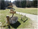 2
2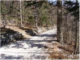 3
3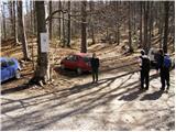 4
4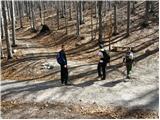 5
5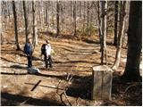 6
6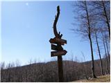 7
7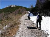 8
8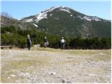 9
9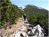 10
10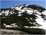 11
11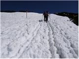 12
12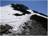 13
13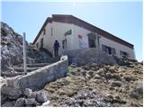 14
14 15
15
Discussion about the trip Sviščaki - Snežnik (footpath)
Show older messages
|
| Gost18. 04. 2007 |
I'm interested which of the two accesses to the starting point is shorter (time-wise), if you set off from LJ? What's the condition of the gravel road (just potholes or something better? ) )
|
|
|
|
| Tadej18. 04. 2007 |
Via Cerknica it's about 15km closer but good 20 minutes longer. Better option seems to me via Ilirska Bistrica, where orientation is also easier. From Cerknica the gravel is around 25km and quite good, last Sunday there were few potholes. From Ilirska Bistrica it's less than 10km. Lp
|
|
|
|
| Gost19. 04. 2007 |
Thanks for the information! Regards
|
|
|
|
| Damijan13. 05. 2007 |
Yes, this trail from Cerknica to Sviščaki through the forest really drags on, so it's better to go via Ilirska Bistrica, and mostly you drive on asphalt. Otherwise, this tour is easy, not too steep ascents, in short suitable for everyone.
|
|
|
|
| katjuša224. 06. 2008 |
But we're heading there tomorrow
we'll go via Cerknica
as predecessors wrote, the path may be longer or more on gravel but it is also much more scenic.
you can drive along Lake Cerknica, on the left admire the magical Slivnica and enjoy the view of Snežnik castle and the castle park.
 I think this can also be part of a hiking tour, because just up the hill and then quickly down via super road somehow ruins the trip and impressions I think this can also be part of a hiking tour, because just up the hill and then quickly down via super road somehow ruins the trip and impressions
usually gravel roads attract me almost more than fast roads where you only see a fence and forget all the beauties that nature offers us,
best regards
|
|
|
|
| nejc*3. 10. 2008 |
Does anyone know what the conditions are like at the top of Snežnik? Nejc
|
|
|
|
| MartinaZ4. 10. 2008 |
I called up there because I'm also interested. They say at the hut that the conditions are not very favorable, because there's fog and an icy path.
|
|
|
|
| Benč22. 12. 2008 |
What are the current conditions for access to Snežnik?
|
|
|
|
| ervinplaninec1. 02. 2009 |
I have a question, is there any snow on Snežnik in March and are the views good in March and April
|
|
|
|
| Tadej1. 02. 2009 |
There is snow on Snežnik until May, but the views are always nice in good weather.
|
|
|
|
| fpetel13. 02. 2009 |
Snežnik is the first barrier to moist air from the sea to the mainland. During most weather changes or even a bit before, there is fog and bora on the summit (sometimes unexpectedly). Usually there is a lot of precipitation and super views in good weather (Most Slovenian hills and Italian Dolomites as if on the palm of your hand. Of course, the Trieste gulf and northern Kvarner are also nicely visible.). The trip is not particularly demanding in any season, except if there is strong bora or ice.
|
|
|
|
| Cveto Meglič11. 02. 2009 |
Is the road to the mountain hut at Sviščaki passable in April with a large bus?
|
|
|
|
| fpetel111. 02. 2009 |
The last half of the road from Ilirska Bistrica is macadamized, but also plowed in winter and passable at least for cars, I think also for buses. In April there is usually not much snow on Sviščaki and there are no major problems - I think conditions to Sviščaki could already be mostly summer-like then.
|
|
|
|
| florjan31. 03. 2009 |
How much snow is still on Snežnik.
|
|
|
|
| Klin1. 04. 2009 |
There is still 2-3 meters of snow on Snežnik.
|
|
|
|
| urosl8. 05. 2009 |
What about now, is there still any snow? Thanks
|
|
|
|
| mad matheuss8. 05. 2009 |
On Monday, 4.5.09, when I visited the summit alone, there were still small snow patches just below the summit, which of course cause no problems. Along the path through the forest there are still some remnants, which are also no issue for a hiking mountaineer. On the ridge from Veliki Snežnik to Mali Snežnik there is still quite a lot of snow, at least 2 meters, but it did not sink under me. Only slight caution is needed, as there are larger holes between the snow and the bushes. Good luck!
|
|
|
|
| Blaž M13. 06. 2009 |
Hello!
I'm wondering if it's possible to reach the top of Snežnik by bike? It counts even if you push it for at most about 500 m due to the terrain.
many thanks
|
|
|
|
| mstrman227. 06. 2009 |
Blaž, you can go to Snežnik by bike, but not right to the top, from Sviščaki to below the summit (where the hut is already visible) it's a very nice trail (possible by bike), further on it'll be tough, although in the hut they have a picture hanging on the wall of two guys who are pictured right at the top with bikes (real pros - hats off). Blaž, I recommend you go to Blegoš by bike from Poljane uphill, there it's awesome, and you'll grind like crazy.
In general, to Snežnik it's a very nice trail also for families with small children or older folks, really easy, super....
|
|
|
|
| Blaž M27. 06. 2009 |
Thanks mstrman2!
If all goes OK, someone else will reach Snežnik summit by bike this year too.
Regarding Blegoš, yesterday I was by bike to below Blegoš (that's 3 km before the hut) but I already had 50 km of Škofja Loka hills behind me plus another 2 hours home and it was almost 19h, so I didn't dare go further up, and it was raining too... Anyway, I'll try that soon, as I've been there on foot many times already. Thanks for the reply and I recommend myself for advice and ideas.
|
|
|
|
| Enka17. 10. 2009 |
Nice, well-marked path, and at the summit wonderful views in all directions. The kids were really delighted with the brought logs .
|
|
|
|
| rjudnic19. 10. 2009 |
Is there any snow yet?
I plan to go this weekend, interested in current conditions.
Thanks
|
|
|
|
| Enka19. 10. 2009 |
Doesn't belong here, but okay. There's just a trace of snow, the path is muddy. At the top where it blows (last few metres below the hut) it's already a bit icy. But still OK.
|
|
|
|
| maremw19. 10. 2009 |
I'm wondering if the sinkhole on the northern slope is already protected
|
|
|
|
| Fazo19. 10. 2009 |
The sinkhole is protected more or less... a braid is strung around on small posts. The first snow will cover everything...
|
|
|
|
| nina_8221. 10. 2009 |
Yesterday my boyfriend and I were on Snežnik. As already mentioned, there is sample snow in the scree area (about 2cm), the upper part of the path before the hut is icy and it was blowing wildly...brrrr... unfortunately we didn't see the view due to fog otherwise it was great and the nature there is truly magnificent! otherwise it was great and the nature there is truly magnificent!
|
|
|
|
| VikiM20. 11. 2009 |
Yesterday was a really nice sunny day. Sviščaki completely in fog. After 5 min of walking, only sun. Wonderful, no wind, nothing.
Wonderful!!!
|
|
|
|
| visa8610. 05. 2010 |
Yesterday I was on Snežnik. The weather wasn't ideal, as we walked three-quarters of the way in fog, but at least it didn't rain. Some patches of snow are still visible around the path, the path itself is mostly dry, so the ascent is suitable also for hikers not used to walking in winter conditions.
|
|
|
|
| nisa2. 06. 2010 |
The weather forecasters promise a nice weekend. We plan to
visit Snežnik. Please for information:
1. Is the hut open?
2. What are the snow conditions (new snow)?
Thanks and best regards.
|
|
|
|
| rjudnic2. 06. 2010 |
I doubt there's any new snow, and if there is, it's gone by now, I was end of May and there was none on the path
hut is open on Saturdays, Sundays and holidays
|
|
|
|
| rs562. 06. 2010 |
I was up there on Sunday. From Gašper to the summit the path is dry without mud. Snow only remains in some depressions. It is true that Snežnik whitened on Monday, but it melted immediately. The hut is open on weekends throughout the winter anyway. Best wishes to Janja and Slavko.
|
|
|
|
| nisa3. 06. 2010 |
Thanks for the replies. I can hardly wait for Saturday.
LP
|
|
|
|
| amar nat22. 07. 2010 |
Hi,
can someone help please - which path to Snežnik is nicer: from Sviščaki or from Gašperjev hrib? Thanks and have a nice day.
|
|
|
|
| katjuša222. 07. 2010 |
I usually go from Sviščaki myself.
And also from Leskova dolina.
|
|
|
|
| amar nat22. 07. 2010 |
I've also gone from Leskova but it's very long. So we planned to go from Sviščaki but an acquaintance advised to go via Gašper (supposedly better views). I've been up here puffing before but many years ago, so I forgot how it is.
We'll pick one, just hope the weather holds on Saturday.
|
|
|
|
| marco22. 07. 2010 |
The trail from Sviščaki (variant through the forest - right at Sv. Gašper) is gentler and most of it runs through more or less managed (read: logged) forest, which is quite well maintained but a bit monotonous. The variant along Snežnik Road (left at Sv. Gabrijel) is cut into the steep slope and feels quite "alpine" and is more scenic than through the forest. Both join at the start of the Snežnik Reserve at "Kapetanovi bajti" (no hut there, just the name from the times when JLA soldiers camped here, who with the help of hikers built the Snežnik Road), from there the trail continues along a poorer road to its end ("Obračališče"). From there, 30-45 min through scree, which steepens only in the last 10-15 min. So quite a steady ascent in terms of steepness.
The trail over Gašperjev hrib, however, is much steeper, both through the forest and the last part through scree, the summit ridge is also steep, it levels out only for a while on the clearings and the initial ridge. But this trail is much more "wild" as the forest is practically from the parking at Gašperjeva cesta all the way on the edge or in the reserve itself. The terrain on this side is also much more riddled with rocks, boulders, cliffs and wild gullies than on the Primorska side, you also cross two or three mountain meadows with all their flowers, on one there are also remains of the first hut on Snežnik with a memorial plaque (Quoting Vojko Čeligoj: The Primorska section of the German-Austrian mountaineering association from Trieste built a mountain hut on the eastern side of Snežnik on 19.7.1874, the first mountain hut in Slovenia. The German poet Rudolf Baumbach, author of the inscription of the famous Trentarian legend of Zlatorog, also actively participated in the construction of the hut.).
|
|
|
|
| amar nat22. 07. 2010 |
Thanks for the help! I can hardly wait! Best regards
|
|
|
|
| Iguana20. 08. 2010 |
A day perfect for visiting the mountains. I head to Snežnik. Nice hike, not too strenuous, for old bones . However, at the top I was disappointed. Not a single bench in front of the hut to sit down a bit. . However, at the top I was disappointed. Not a single bench in front of the hut to sit down a bit.
There were quite a few hikers up there that Saturday.
In the hut everything was occupied and of course looooooud, which can be annoying. Unfortunately, some hikers, probably a group, were also trying to keep up the shouting outside. So I quickly headed towards Mali Snežnik, where it was a bit quieter, and ended the day with a shot of bitters.
|
|
|
|
| carpediem10. 10. 2010 |
A sunny day like today is worth taking advantage of to visit Snežnik. Even this Saturday the hut was full to the last corner, but the extremely friendly staff deserves praise. The hike is not demanding, if you want you can make it a bit harder by carrying firewood to the hut :-)
|
|
|
|
| knauf27. 10. 2010 |
Does anyone know until when the hut on Snežnik is open.
|
|
|
|
| Karletto27. 10. 2010 |
The hut is open from 1 May to 31 July and from 1 September to 31 October on Saturdays, Sundays and holidays, in winter only if weather conditions allow. From 1 August to 1 September the hut is open every day. Especially in winter we recommend checking the opening status beforehand with the manager. The manager also asks that larger groups announce in advance.
051/615-356 and 041/595 879
E-mail: pd.sneznik@email.si and skobi@siol.net
|
|
|
|
| knauf28. 10. 2010 |
Thanks for the help!
best regards
|
|
|
|
| Irina7. 02. 2011 |
Hut open, weather as if painted..... nice day invites.
|
|
|
|
| mojcej'7214. 06. 2011 |
With a colleague we headed to Snežnik on Friday 10.6. The trip was pure idyll. No scorching sun and no rain, a bit of wind on the top, so we had our snack at three masterfully placed benches by the hut. Met only 5 hikers - what better on a day when others are at work.
|
|
|
|
| dardan5. 07. 2011 |
Everyone praises the trail, which is great. But I would praise the hut keeper, always friendly and smiling, making it really pleasant at the top. We visit Snežnik at least once a year. Now everything is blooming up there, on Sviščaki you can treat yourself to forest strawberries and raspberries....of course if you find them on the clear-cut.
|
|
|
|
| Balky795. 09. 2011 |
Nice greetings.
I found the hike via hribi.net, and everything says "easy" to Snežnik, so the day before yesterday (03.09.11) I took my parents hiking I modified the trail a bit, and it turned out quite demanding, here's the trail: Sviščaki - Mali Snežnik - Snežnik
Gorgeous! Now looking where to go next weekend, but we need something easier, as mom almost quit
|
|
|
|
| Daniyel18. 09. 2011 |
Yesterday visited the karst daddy as well. Came from the Ilirska Bistrica direction, left towards Cerkno (highly recommend Ilirska Bistrica direction, as the 28km gravel towards Cerkno dragged like a slow snail ).
Started from PD Sviščaki a bit late but arrived at the summit in under 2h. Weather partly cloudy, so no strong sun to feel. Lots of hikers, mainly a group of kids. The view compensates all the effort.
At the chapel in the forest where there's also "parking", you can continue by car further to the starting point which is only 1h to the top.
At the cross in the forest keep left. I went right and wandered in the forest until I reached the marked trail again, some off-trail sections too and remoteness from other hikers.
LP.
|
|
|
|
| Okmodko19. 10. 2011 |
I was looking at Snežnik a bit on Google Earth and viewing pictures. Then I see that on many pictures it says Monte Nevoso. Actually, this name predominates on pictures over the name Snežnik. I started thinking, how come it has an Italian name when Italians never lived there. With the help of the internet, I found out that this name is from 1920 when during the occupation the fascists Italianized the names of our places. Then I noticed that Italians use these fascist names for all places located in the territory that was occupied between the two world wars. There are many pictures from Bovec to Snežnik named with these names. When I tried to tell them this and also showed them a list of Italianized names, they labeled me a racist, idiot and similar. And told me it's 2011. But why do they use names from 1920 then. I know that nevoso means snowy and it could just be a translation, but it's obvious it's not just a translation, since many other surrounding places are written with Italian names that are just distortions from 1920. Is it right to allow this? I don't think it's very nice.
|
|
|
|
| Janiel7411. 11. 2011 |
Is there any snow on the path?
|
|
|
|
| Kokta20. 11. 2011 |
No snow at all.....I recommend the trail from Ilirska Bistrica, the macadam section of the road to Sviščaki is in excellent condition, I recommend a visit...suitable for everyone. Service in the hut is phenomenal, as is the jota and strudel. Weather fantastic, sunshine and almost no wind...fog in the valley
|
|
|
|
| nitram17. 12. 2011 |
Does anyone know how the conditions are on Snežnik?
|
|
|
|
| Indi17. 12. 2011 |
Today on the path from Sviščaki there was snow on the path mostly up to below the knees (30-40 cm). It was windy only for the last 10 minutes, but visibility reached Osorščica. Tomorrow the mountain hut will also be open.
|
|
|
|
| vik18. 12. 2011 |
Today we went early, -10 showed the thermometer, the half moon also shone to help. Wonderful sunrise from the top and then unique, long views, Kvarner, islands, to S and SW even further over our peaks that shone in the morning sun. Warm in the hut already, strudel ready, štruklji just done. Then back to the valley in sun and no wind. Completely forgotten the fog and 10m visibility at dawn last Sunday on top of Krn (where it was otherwise great too).
|
|
|
|
| gojko12319. 12. 2011 |
Does anyone happen to know how much snow there is at Sviščaki or if it's possible to ski from Snežnik?
|
|
|
|
| ozo19. 12. 2011 |
and is the road to Sviščaki nicely maintained?
|
|
|
|
| dwji19. 12. 2011 |
Just got back from Sviščaki
up there is about 20 cm of snow and it's windy on the road, with winter tires you can easily drive, deeper snow is plowed
towards Snežnik probably not, I haven't been up there, only if there are 20 cm on Sviščaki I don't believe Borovce is covered
lp
|
|
|
|
| mtjkristan29. 12. 2011 |
Yesterday afternoon I was on Snežnik. The road is nicely drivable and gritted. The trail is trodden, little snow. The weather was great, very warm, quite a few visitors. The hut is closed, so we emptied our backpacks and sunbathed. Waited for sunset then down to Sviščaki for mulled wine.
lp
|
|
|
|
| marco31. 12. 2011 |
When I last counted (yes, I literally walked all over Sviščaki with a sketch in hand and noted) about 7-8 years ago, the situation was as follows: 91 "weekend houses", of which 4 "doubles" + family home + garage for snowcat with apartment for the operator + hut at the ski slope of the ski club... yes, a whole mountain/forest village, if not a small town...
|
|
|
|
| grand31. 12. 2011 |
How is the trail to the summit of Snežnik (snow depth, icy)? Lp
|
|
|
|
| vik31. 12. 2011 |
I was there on Wednesday, on several trails, but given Javornik today and Nanos yesterday, I think no more than 10 cm of new snow fell. Some "microspikes" for the upper part might be advisable, but not necessary, just more cautious steps. New year, nice day, see you up there.
|
|
|
|
| mtjkristan22. 01. 2012 |
Today on Snežnik foggy and windy. The lower part is trodden, hard base, higher up a bit icy and wind-blown. The hut is open so a hot tea fits nicely. Štruklji excellent as always. lp mk
|
|
|
|
| JanezsJohn1. 02. 2012 |
Hi. How much snow is there on Snežnik now? Is it possible to ski through the bushes on the northern/inner side? If yes, up to where? Thanks for the reply.
|
|
|
|
| Domc3. 02. 2012 |
Last month I was up there three times, conditions weren't suitable for skiing yet. Maybe now more snow has fallen, I'll report :) the hut won't be open this weekend.
lp D
|
|
|
|
| bug23. 02. 2012 |
Hi. Does anyone know the current conditions on Snežnik (snow depth and iciness)? Thanks
|
|
|
|
| BOYŠ24. 02. 2012 |
Hi
Plenty of snow, on Sviščaki about half a meter of new snow, higher up too, quite a few drifts. But at such temperature as today it won't last till end of month. Trail ok, gritted, from Sviščaki up also, trodden but sinks in......but today for the first time this winter I skied the entire route, along the trail though.
|
|
|
|
| namor28. 03. 2012 |
Hi. I'm wondering how much snow is left on the path to Snežnik? Lp. Thanks.
|
|
|
|
| Wrlk8. 03. 2012 |
I'm also interested in how much snow is left on Snežnik? Thanks.
|
|
|
|
| jbar8. 03. 2012 |
Was up there on Sunday 4.3. There's still some snow. Actually, the trail from Sviščaki up is partially icy (at least in the morning, on the way back in the afternoon it softened a bit) and almost entirely snowy. I didn't use crampons myself, but it's easier with microspikes. Lp.
|
|
|
|
| istrumel18. 03. 2012 |
I was up there on Friday 16.3. Conditions the same as the previous one, but you can get there nicely even without crampons. lp
|
|
|
|
| Darxta26. 08. 2012 |
I haven't seen it written anywhere, so let me mention:
At the end of the road there is a pile of chopped wood that visitors can carry to the hut. Worth leaving some space in the backpack
|
|
|
|
| katty23. 09. 2012 |
Yesterday on Snežnik. Which wasn't friendly at all. In the morning reportedly clear skies on the summit, sunny and warm, later completely different picture. Strong wind, fog and cold. But still huge crowds, so staff had plenty to do. Trail to the starting point in very good condition, and the footpath is quite nice. At the place with chopped wood, usually a spot for a break...There's lots of wood, so carry it up. You'll do a good deed. And the feeling in the heart is really nice The day was still long, so we visited Snežnik castle at the end. We drove along the entire ridge of this Primorska Triglav. It dragged like resin. Otherwise an interesting and varied day.
|
|
|
|
| babim23. 09. 2012 |
My husband and I also got some fresh air on Snežnik yesterday. Up to halfway it was quite pleasant, then steadily worse. On the summit itself it almost swept us away, so we quickly stepped into the warm and friendly hut for a good drink. We probably met somewhere.
|
|
|
|
| Naty42. 01. 2013 |
Good evening everyone, I'm new here, I'd like to ask if anyone knows what the situation is for Snežnik with crampons and if the paths are properly marked... Thank you all and happy 2013
|
|
|
|
| jax3. 01. 2013 |
Okay, like this: the paths are super marked, but in snow you'll have a harder time following the marks. But Snežnik is very visited anyway so there's definitely a track made.
As for crampons, like this: in good conditions you don't need anything. But Snežnik is quite windy, often windblown and icy. And if you're up there in such conditions, crampons (and ice axe!) really come in handy in the summit area. But well, in most cases it's just an easy, short and enjoyable trip. It's nice to have the gear with you in case of surprises.
|
|
|
|
| mukica3. 01. 2013 |
Up there on 29.12. nice track made, but locally icy so small crampons come in handy. The path is marked and nicely traceable...
|
|
|
|
| bernc3. 01. 2013 |
Today foggy and windy. Track and marks well visible, at the top windblown snow below a bit icy crampons in the backpack and good luck
|
|
|
|
| hribov.ec9. 01. 2013 |
Hello, can someone tell me how drivable the road from Ilirska Bistrica to Sviščaki is? I think I read somewhere that there are problems. Thanks!
|
|
|
|
| marco10. 01. 2013 |
The road is icy in places but still nicely drivable, as there is still some sand scattered on the icy patches. But there will be a new batch of snow on Sunday and Monday, and I reckon they will plow and salt on Monday or Tuesday.
|
|
|
|
| amarilis12. 01. 2013 |
Marco @ With the road it's really as you informed us. Let's wait for the promised snow that the meteorologists are promising us. And the sand for spreading and the funds will be found too. Hikers visit it very gladly, even in these winter days, it never lacks visitors. LP
|
|
|
|
| SuzanaM13. 01. 2013 |
Yesterday on Snežnik it was a beautiful day. Branches decorated with spruce twigs, sunlit sea shining under the cloud blanket. At the top fluffy snow sculptures. At the end of the path gentle snowflakes caressed us. Really fairy-tale.
|
|
|
|
| SuzanaM13. 01. 2013 |
Photos under Forum-current conditions.
|
|
|
|
| akuL15. 01. 2013 |
As SuzanaM already said and as my friend says, on Saturday it was real eye candy! We probably met somewhere too
|
|
|
|
| tusekeva30. 01. 2013 |
I advise everyone who will visit Snežnik in winter to DRESS WARMLY and go only if sunny and clear weather is forecast. We went up last Saturday and I must admit the ascent was very strenuous as the wind hindered our path. As young hikers we awakened the child in us, as we threw snowballs and rolled in the snow, so don't wonder why the path is so churned up, undoubtedly it wasn't 200 of us but only 20!
|
|
|
|
| Holcar231. 01. 2013 |
How much snow on Snežnik? Do you need gaiters, crampons, ice axe and that extra gear? Thanks for the answer.
|
|
|
|
| vik31. 01. 2013 |
https://picasaweb.google.com/100148357817993061964/Sneznik2612013
now there is less of it, it was last Saturday, there are still some among albums, Snežnik ones I mean.
tusekeva - We were already returning when I photographed you. Because we went in the morning into drifted track, we missed sunrise, caretaker with team walked 4 hours from Sviščaki previous day. Despite being our home mountain in Notranjska, it is high alpine and conditions are accordingly harsh especially in winter, even in clear and sunny wind was over 100. But wonderful in every season and weather. Some in your group were properly cold, judging by gear, but great that you enjoyed. Always happy to see young people in the mountains.
|
|
|
|
| jax1. 02. 2013 |
Despite being our home mountain in Notranjska, it is high alpine
Well yeah...
|
|
|
|
| Holcar22. 02. 2013 |
Today forecast up to 25 cm snow.
With that statement Snežnik is high alpine, I agree and don't know why you're bristling at it. Altitude is right so what if you can't exactly climb some via ferrata up there. Officially high alpine above 1500m, regardless of terrain.
|
|
|
|
| jax2. 02. 2013 |
Ah no, I seriously think that no one who has been in the high mountains would classify Snežnik in that group too. Officially, it should be (at least in Slovenian conditions) high mountains somewhere above 2000m, although I would move the boundary a bit higher - around 2200-2300 meters. Once you reach that altitude where vegetation is more or less gone and it's just moving over scree and rocks, the world simply changes quite a bit. The feeling of moving in actual high mountains is different from mid-mountains and - sorry - Snežnik doesn't give the high mountain feel. And I'm not denying that there can be plenty of snow there too and that the bora blows hard. But that doesn't make it high mountains.
And please - up to 1500m it's forest! And you claim that when you come out of the forest, it's already high mountains. Come on...
|
|
|
|
| marco2. 02. 2013 |
Well... actually both are true - it is and isn't in the high mountains (welcome to Slovenia 
).
At the PZS courses I've attended so far, high mountains were defined as the area above the upper tree line or above 1500m, but the altitude can vary:
Wikipedia: above 1500m
Interesting to read this:
Definitions of high mountains vary considerably.
Thus in the Geography lexicon (2001, p. 595) high mountains are defined as:
"Mountains with steep and precipitous walls and other sharp-edged relief forms, characterized by large elevation differences often exceeding 1000 m, and sharp peaks and ridges, result of glacial reshaping of the surface. Large part of the surface rises above the upper tree line; the highest areas are glaciated.
Best known examples are the Alps, Caucasus, Rocky Mountains, Andes and Himalayas."
So we see that this definition defines high mountains as a synonym for high mountain ranges and as such defines ranges that rise higher than others and therefore have special characteristics.
On the other hand, the Mountaineering Terminology Dictionary (2002, p. 249) defines high mountains as:
"Mountain world that in our geographical latitude extends above 2000 m above sea level."
So we see that it's a different definition, based on altitudinal belts, defining high mountains as the highest (at least with us) belt in the mountains. Belt that extends above the upper tree line.
Thus in the same dictionary (2002, p. 214) mid-mountains are defined as:
"Mountain world extending to the upper tree line."
Categorization of mountaineering huts by the Economic Commission (GK) of PZS, confirmed by the PZS management board in 1993:
When categorizing huts, two main criteria were decisive. The first is location, whether it's a hut in high mountains or mid-mountains and thus
related importance of the hut (attractiveness for visitors). In this case, Julian Alps, Karavanke and Kamnik-Savinja Alps are classified under high mountains. The second criterion is accessibility. Here, the access limit to the hut is considered, at least one hour walk, which means elevation difference over 300 m, or distance over 4 km. Huts where access takes more than an hour. Here the access limit to the hut is considered, at least one hour walk, meaning elevation difference over 300 m, or distance over 4 km. Huts where access takes more than an hour and are in high mountains are classified in the first category (What is a mountaineering hut, 2012).
Koča Draga Karolina on Big Snežnik is in category I.
|
|
|
|
| Holcar22. 02. 2013 |
@jax: I didn't claim that in my opinion high mountains are above 1500 meters but that officially it should be like that. I've seen this info elsewhere besides Wikipedia and since there are so many different definitions of high mountains, I believe the definition of the high mountains boundary is "to each his own." With careful reading of my otherwise short comment, it's noticeable that I didn't give my own opinion on it. Snežnik is well above the tree line anyway. Now I think the best alternative would be the world above 2000 meters.
|
|
|
|
| Holcar22. 02. 2013 |
Otherwise, it's different with the definition of mountain climate, which is supposed to start somewhere around 1300-1500 meters and of course intensifies with altitude.
|
|
|
|
| Holcar22. 02. 2013 |
@marco also said that the information about the high mountain boundary at around 1500 meters is taught in PZS courses, which should not be disregarded.
|
|
|
|
| ozo4. 02. 2013 |
hi. how is the road from ILIRSKE B.-SVIŠČAKOV arranged, would it be passable with mountain bike? jan&oZo
|
|
|
|
| marco4. 02. 2013 |
Yesterday they plowed up to around 14h (30 to 35cm of new wet snow on rain-soaked snow/ice base), but apparently the snowplow broke down at Sviščaki (it's old junk), so I assume it only plowed one width for uphill.
The pusher coming from behind then has nowhere to push the snow, so...
I wouldn't descend by bike in the snowy period into icy/snowy/wet/dirty conditions, if nothing else because it's not everywhere plowed to hard ground and consequently narrow bike tires aren't exactly best suited for such surfaces...
|
|
|
|
| ozo6. 02. 2013 |
Thanks, Marco, for the report. I'll head to the neighboring Učka instead. lp.jan
|
|
|
|
| MarkoBencina19. 02. 2013 |
Hello hikers!
I'm interested if anyone has experience with ski descent from Snežnik. Weather forecast is snow until Sunday.
Is the path to Sviščaki passable soon after snowfall? What to pay attention to during ascent and descent from snowy Snežnik?
Any information you share will be welcome, thank you for the answers.
Best regards!
|
|
|
|
| Holcar219. 02. 2013 |
The path to Sviščaki is usually quickly plowed, if going to Snežnik in winter dress warmly and equip with all additional gear (gaiters, ice axe, crampons..) because it's wintry, as Snežnik in general is unpredictable.
|
|
|
|
| Holcar219. 02. 2013 |
The burja often blows, creating large drifts, lots of precipitation, various weather influences mix on it.
|
|
|
|
| Holcar219. 02. 2013 |
For skiing let someone else write something, unfortunately I haven't skied from Snežnik.
|
|
|
|
| Daaam19. 02. 2013 |
On the summit section watch for fog if you don't know the path... especially if skiing.. Wind, which is quite frequent, quickly covers predecessors' tracks.. in the forest section of the path there are no major "traps"
|
|
|
|
| Daaam19. 02. 2013 |
On the summit section watch for fog if you don't know the path... especially if skiing.. Wind, which is quite frequent, quickly covers predecessors' tracks.. in the forest section of the path there are no major "traps"
|
|
|
|
| Janez Seliškar2. 04. 2013 |
In the case of reasonably favorable weather conditions, Snežnik is also massively visited in winter. Especially on weekends, when the hut is usually open with a friendly host couple.
So just boldly up there with appropriate gear and experience.
If the summit slope is too demanding, you can turn back already at the saddle below Mali Snežnik (from the Sviščaki direction).
|
|
|
|
| jedriličar7. 04. 2013 |
When high mountains are not possible, at least some conditioning tours to Snežnik. Weather so-so, everything in clouds, strong bora blowing, cold, lots of snow, good conditions for walking. Path trampled, doesn't sink in, ridge not frozen either. Not many people, more skiers than hikers. Hut at the top closed. No views from the top ... but some pics
|
|
|
|
| smatjaz4. 05. 2013 |
Does anyone know what the conditions are like on Snežnik from Sviščaki? Are crampons still needed? Thanks
|
|
|
|
| _sandra_4. 05. 2013 |
it's dry, just a bit of snow a little below the summit, no crampons needed, the snow is south-facing..
|
|
|
|
| smatjaz4. 05. 2013 |
Sandra, thanks, I'll conquer it next weekend.
|
|
|
|
| smatjaz19. 05. 2013 |
Conquered the summit today. Snow just a trace left, only bora is the problem! Above the hut you almost need to tie yourself so it doesn’t blow you into the valley, otherwise it’s a fantasy!!!
|
|
|
|
| nanica16. 06. 2013 |
Today we set out again in the Notranjska hills. After Nanos last week today Snežnik in turn. Path b.p., quite warm, but quite a lot of hikers today. At the top even a small brass band. Vistas today were not very clear, but therefore we could observe and admire the diverse alpine flowers along the path and on the top in abundance more precisely.
|
|
|
|
| matejaz7. 08. 2013 |
I'm wondering if it's possible to take a dog on the trail, is it dog-friendly? And which trail would be the best choice also for dog company? Thanks
|
|
|
|
| otiv8. 08. 2013 |
No obstacles for dogs, just that they are used to longer hikes.
|
|
|
|
| omojcej18. 12. 2013 |
On Sunday 16.12.2013 we climbed to Snežnik. If it had been nicer it would have been kitschy.
|
|
|
|
| Petra I.20. 01. 2014 |
Has anyone been up there recently? Because we plan to go up on Sunday if the weather is nice... thanks
|
|
|
|
| Pinokijo22. 01. 2014 |
Today in the afternoon hours I was up there. The path to Sviščaki is passable, no snow.
From Sviščaki to the top of Snežnik it's frozen scree. I walked the path with crampons, no major problem to reach the top. Today there was fog and no visibility.
|
|
|
|
| jernej12323. 01. 2014 |
I'm wondering how to even get to Kozarišče, because it's flooded, road closed, otherwise how to get to Sviščaki, today I wandered on such paths oh boy, if anyone knows please tell.
|
|
|
|
| jernej12323. 01. 2014 |
Yeah, from Kozarišče you can't get to Sviščake at all because everything is flooded, I don't know about the roads, if anyone knows let me know, I drove on such paths when they drag wood down with a tractor, it's oh boy, locals have no idea I asked them, or they don't want to tell.
|
|
|
|
| rs5623. 01. 2014 |
You'll find the path most easily if you go to Babno polje. At the shop turn right, at the church right again and drive a few kilometres straight ahead.You arrive above Snežnik castle on the road leading to Leskova dolina. The junction is marked with a direction sign.I don't know how it will be with snow this weekend in our area.The most is forecasted right here
best regards
|
|
|
|
| Pinokijo24. 01. 2014 |
You'll have an even easier path from Ilirska Bistrica, it's 19 km to Sviščaki.From here on foot 2 hours to the top of Snežnik if there is no snow.
|
|
|
|
| jernej12324. 01. 2014 |
Rs56 aha thanks, but now I think there is a lot of snow, when it's clear I'll come, when the road is ok.
|
|
|
|
| jernej12324. 01. 2014 |
Pinokijo: I have 46 km to Ilirska, but from my end to Sviščaki I have 49 km.
|
|
|
|
| rs5624. 01. 2014 |
This week you won't get through our end. Even the road to Šmarata village and Kozarišče is difficult, further to Leskova dolina probably even more snow
best regards
|
|
|
|
| katjusssa21. 02. 2014 |
Hello! What are the conditions like, has anyone been to the mountain in the last few days? Best, K
|
|
|
|
| ajax21. 02. 2014 |
you can also call the hut keepers.
|
|
|
|
| ifo3. 03. 2014 |
Has anyone been to the summit? Is the path from Ilirska Bistrica to Sviščaki drivable with a passenger car?
|
|
|
|
| Pinokijo3. 03. 2014 |
The path to Sviščaki is drivable. To the top there was fog and strong wind so we didn't go to the top.
|
|
|
|
| rozmanjan10. 03. 2014 |
On Sunday 9 March I wanted to go to Snežnik from the Ilirska side and the path at the junction to Sviščake 10km before the hut was blocked with trunks so the trip in perfect weather was cancelled.
|
|
|
|
| Fulcrum10. 03. 2014 |
I was at Snežnik one day earlier (8.3.) and then the road was still OK. But it's true that I wasn't so lucky with the weather, as it was quite windy.
|
|
|
|
| skala12310. 03. 2014 |
I was (9.3) at Snežnik and the road from Ilirska Bistrica was normally passable, but towards Stari Log it is closed due to ice storm.
|
|
|
|
| tk717. 04. 2014 |
How is the path to Snežnik, is winter gear still needed? Thanks for the reply!
|
|
|
|
| Irina18. 04. 2014 |
Spring. Snowdrops and spring snowflakes, no snow left anywhere.
|
|
|
|
| marco18. 04. 2014 |
Snapshot from the path 5-6 days ago ...there is some snow, but only here and there in drifts and of course the last steep section:
http://www.sneznik.net/?p=2420
|
|
|
|
| matdra5. 05. 2014 |
Was up there today, trail completely dry, nice weather and almost no wind. But the trail via Cerknica really draaaaaaaaags on.
|
|
|
|
| Carpinus8. 05. 2014 |
Hello!
I'm wondering which trail you recommend for Sviščaki. From Knežak or from Ilirska Bistrica. Which one is nicer, less winding, better?
|
|
|
|
| matdra8. 05. 2014 |
Definitely the one from Ilirska Bistrica is better and less winding.
|
|
|
|
| ifo2. 03. 2015 |
What is the road to Sviščaki like?
|
|
|
|
| billzkid26. 03. 2015 |
2 questions. Nice weather forecasted for the weekend, so Snežnik is also an idea.
1. question
Is the road to Sviščaki from Ilirska Bistrica accessible with summer tires (no rush to change )
2. What is the path to the top like. Are crampons necessary?
Thanks
|
|
|
|
| vavtora19. 04. 2015 |
Does anyone know how much snow fell yesterday on Snežnik? Are crampons needed? Is the hut open? Thanks and have a nice day.
|
|
|
|
| ajax19. 04. 2015 |
Check the webcam, for the hut call the caretakers
|
|
|
|
| vavtora19. 04. 2015 |
Thanks - we were on Snežnik, in the morning there was quite a lot of snow but during the day it melted, crampons helped towards the top. Nice winter day!
|
|
|
|
| boma17. 01. 2016 |
Yesterday on Snežnik and Sviščaki. In the morning already at Sviščaki -4 degrees indicated a cold day. At the start and along the path about 25-30 cm of snow which the wind sweeps into drifts. At the top unfortunately fog and gale at -9 degrees. Hut open and very high attendance for such a day.
|
|
|
|
| mmihaappravnikk17. 01. 2016 |
What's the road to Sviščaki like? Normally passable with winter tires and front-wheel drive? Are crampons needed along the path? Thanks!
|
|
|
|
| BrankaM21. 01. 2016 |
Me too interested in the road to Sviščaki and how it is uphill then. Thanks
|
|
|
|
| skobi21. 01. 2016 |
The road to Sviščaki from the Ilirska Bistrica direction is plowed and normally passable with winter tires, further to Snežnik the path is trodden; in places, especially below the summit, I recommend at least small crampons. Good luck!
|
|
|
|
| BrankaM21. 01. 2016 |
We would arrive at the starting point from the direction of Cerknica. But how is the road on this side? Thanks
|
|
|
|
| jax21. 01. 2016 |
Maybe you'll make it, but as a rule this road is closed in winter. I much more recommend driving around to Bistrica and then up.
|
|
|
|
| marco22. 01. 2016 |
For the condition of the road Kozarišče - Leskova dolina - Mašun, it's best to call directly the guesthouse Mašun, (031 623 053).
|
|
|
|
| marco22. 01. 2016 |
Aja, and also: ...but the question is what the road from Leskova dolina to Gašperjev hrib is like, which saves us about an hour of walking.
|
|
|
|
| SunBurned23. 01. 2016 |
The information is not current, as I walked around there a few years ago, but at that time it was a very well maintained gravel road.
|
|
|
|
| nisa10. 03. 2016 |
On Saturday we're heading to Snežnik. Does anyone know what the conditions are like on the road from Ilirska Bistrica to Sviščaki, and how much snow there is further towards Snežnik.
Regards.
|
|
|
|
| Smetar10. 03. 2016 |
@nisa:
Snežnik (1796) (Branko, 10.03.2016)
The path to Sviščaki is nicely groomed. At the parking lot immediately skins on, because there is about 40 cm of fresh powder on about 60 cm base. I broke a new track to the turning point in nice conditions. There I stopped too, because foggy and windy weather was not suitable for enjoyment. Branko
Source: http://razmere.turni-klub-gora.si/
|
|
|
|
| el rocco30. 04. 2016 |
Today my wife and I did this nice little tour... There's still quite a bit of snow, but it's melting fast, so it's more like unpleasant slush you're walking through (especially up top). So I recommend if you don't have waterproof boots, take something to change into ) Otherwise weather is a perfect 10 as are the views and service at the hut......... in short A day to remember ))
|
|
|
|
| MarkoNG8. 02. 2018 |
Snežnik showed one of its nicer faces today. In the morning, you had to wade deep into the snow, which reaches the knees in places.
Otherwise, towards the top it wasn't icy and you could safely climb to the top even without crampons. On the way back, numerous hikers had already made a nicely packed trail. The shelter at the top is closed.
Sun, snow, winter idyll....
|
|
|
|
| marco9. 02. 2018 |
The hut is officially open from today (Friday).
The caretakers were already at the hut since yesterday afternoon.
It will be open until Sunday afternoon.
|
|
|
|
| DamMal23. 02. 2018 |
Last weekend the road from Mašun towards Sviščaki was not cleared. So it's not passable from Pudob side. We drove 45 min to Mašun
|
|
|
|
| marco26. 02. 2018 |
The road from Mašun to Sviščaki is plowed only after May 1st... the road from Kozarišče (Snežnik town) to Mašun is plowed, but not regularly.
There is however a regularly maintained and plowed road from Ilirska Bistrica, which indeed comes last during heavier precipitation, as the villages in the municipality have priority.
|
|
|
|
| san-tane9. 04. 2019 |
Hello. This Saturday my friend and I were at Sviščaki. Namely on foot from Mašun. And on the way back we noticed a memorial plaque carved into the rock. Does anyone know what it was called?________strasse? Thanks
|
|
|
|
| marco9. 04. 2019 |
Hermannstrasse or Hermanova cesta
|
|
|
|
| artur29. 04. 2019 |
Hello.
I'm interested in what the road from the town of Snežnik to Sviščaki is like.
Is there any snow?
regards
|
|
|
|
| bongo30. 04. 2019 |
The road has been closed to traffic for some time. Construction of bypasses and timber extraction, it will remain so until September. I don't know if there's a way around anyway, there's also a closure notice at Sviščaki.
|
|
|
|
| matej630. 04. 2019 |
The road HAS NOT BEEN CLOSED TO TRAFFIC FOR SOME TIME, but is normally passable (by car, bike or on foot) from Snežnik castle to Sviščaki and to Mašun. Occasionally construction works are done on the roadway, but they do not obstruct traffic. Why the road is ˝officially˝ closed to traffic is unclear to both locals and the few tourists who turn into our area. Snow waved goodbye back in February... Good luck
|
|
|
|
| artur30. 04. 2019 |
Thanks for the information.
I spoke with the hut keeper at Snežnik and he said the same, only on weekdays the road is disrupted due to timber extraction.
Thanks and best regards
|
|
|
|
| danielenidoma25. 06. 2019 |
Nice sunny day on the local hill hut open, path without features. Asphalt road to Sviščaki being arranged, supposedly ready by autumn
Lp
|
|
|
|
| martinkrpan9. 08. 2019 |
Dear Sir/Madam,
In three days we are coming to Pivka and planning a hike from Sviščaki to the top of Snežnik. Which is the best path or clearly marked, as we are coming to this area for the first time. And, is the route from Ilirska Bistrica the most pleasant?
Please advise.
|
|
|
|
| stargojzar9. 08. 2019 |
From Pivka to Bistrica. From Bistrica to Sviščaki and on foot to Snežnik. You can't get lost here.
The other variant is from Pivka via Knežak to Masun. From Masun towards Sviščaki, but only to Grda Draga. From there via Mali Snežnik to Snežnik. If you don't know it, it can get complicated.
|
|
|
|
| martinkrpan10. 08. 2019 |
Thank you for the advice. We'll go from Bistrica.
Best regards from Istria
|
|
|
|
| buca 5418. 08. 2019 |
I'm from Kočevje. Which path do you recommend?
|
|
|
|
| rs5618. 08. 2019 |
For you the closest path is from Gašper.
Stari trg, Leskova dolina Gašperjev hrib.
You can drive by car to the starting point.
|
|
|
|
| mirank3. 11. 2019 |
I'm wondering if the path to Sviščaki is fully asphalted?
|
|
|
|
| brencel3. 11. 2019 |
The path is fully asphalted to Sviščaki.
LP
|
|
|
|
| brencel3. 11. 2019 |
The trail is fully asphalted from Ilirska Bistrica to Sviščaki.
LP
|
|
|
|
| leja12313. 12. 2019 |
I'm wondering if the road to Sviščaki is plowed regularly, does anyone know. I'd like to go up tomorrow, but I'm worried about the road because it's supposed to snow all night.
|
|
|
|
| BaroA13. 12. 2019 |
The road from Ilirska Bistrica to Sviščaki is regularly plowed in winter. However, it can happen that in the earliest morning hours it hasn't been cleared yet, as it's not the first priority for plowing.
|
|
|
|
| turbo13. 12. 2019 |
They forecast that 20 to 40 cm of snow could fall in the Snežnik area, so be careful.
"The snow cover will thicken during the day today. By tomorrow morning, 20 to about 40 cm of snow will fall in the Julian Alps. A similar amount is expected on Snežnik, 10 to 30 cm elsewhere in our mountains. It will snow on mostly hard base, so there will be a weak layer under the new snow on which the new snow can slide. Wind will create drifts. In the coming days, it will warm up considerably at higher elevations. Initially, due to the warming, the snow cover will become more unstable. We expect that slab avalanches of non-settled new snow may slide spontaneously first, then also loose snow avalanches, and lower down also ground avalanches on steep grassy slopes. At the same time, the snow will settle and transform faster, and by Monday or Tuesday the snow cover will already stabilize somewhat."
|
|
|
|
| danielenidoma15. 12. 2019 |
@leja123 too bad, because I didn't see your question earlier. The plow went up already before 8am, so up there it was nicely cleared and the road was fine (of course with winter tires). I arrived around 9:30am at Sviščaki, they were just plowing the parking lot and Sviščaki.
|
|
|
|
| Iztok Možina5. 02. 2020 |
Please, site maintainer, correct the path description, as the road is apparently asphalted now.
LP
|
|
|
|
| Lobnican19. 02. 2020 |
Has anyone been to Snežnik, is it icy at all or how much? thanks, lp
|
|
|
|
| BaroA20. 02. 2020 |
On Sunday the upper part of the path was icy in certain places.
|
|
|
|
| miamia10. 08. 2020 |
This Saturday, 8.8.2020, we were up there; besides the sun it was also very windy, but still a great trip. We were all the more disappointed with the catering offer in the hut: only jota, jota with sausage or just sausage was available. Hungry, we ordered jota, which was tasteless, just water and cabbage :-(
|
|
|
|
| bizgo9315. 02. 2021 |
Yesterday, after a long time, we did a winter ascent to Snežnik along the described path and skied back down to the valley. With full gear, it took us just over 2 hours, and crampons were essential for the ascent from the last shelter to the top. It was quite windy below and on the summit, so the cold feeling was intense, but it was worth it. We had practically all of Slovenia, the entire Kvarner with islands, Gorski Kotar and Lika, part of Istria, and the Gulf of Trieste (almost to Venice) in the palm of our hand. The descent was great too - the snow was mostly firm to the bottom, so even we with less off-piste experience had a chance to slide a few times on the icy surface. On top of that, the hut was operating take-away this weekend, so we gladly helped the owner with some drinks in these tough times. Perfect day!
|
|
|
|
| michael661. 04. 2021 10:49:38 |
Up to Sviščaki the road is now asphalted...no more macadam.
|
|
|
|
| grega_p1. 04. 2021 14:05:45 |
Well, it's been talked about for a long time, but I wonder if this is an April Fool's joke?
|
|
|
|
| lozarbogdan1. 04. 2021 15:16:52 |
Grega it's not April Fool's, I was there in December and there is asphalt up to Sviščaki!
|
|
|
|
| grega_p1. 04. 2021 16:49:01 |
Then okay - nice to hear, thanks for the info!
|
|
|
|
| padez1. 04. 2021 20:11:35 |
Not now, the asphalt has been there for quite some time, about two years already...
|
|
|
|
| mornar7. 05. 2021 05:29:57 |
Has anyone been to Snežnik, what's the path like, is there still snow? L.P.
|
|
|
|
| BaroA8. 05. 2021 10:04:35 |
The path from Sviščaki is mostly bare, but there are still quite a few snow patches and drifts, which are frozen in the morning, but soften during the day.
|
|
|
|
| mornar8. 05. 2021 11:40:21 |
Many thanks and best regards.
|
|
|
|
| malihodec28. 05. 2021 19:39:19 |
Path Sviščaki Veliki Snežnik, hiked 26.5. Completely snow-free, only don't recommend vehicle access on the potholed macadam road from Kozarišča to Sviščaki. Better from Il. Bistrica on asphalt
|
|
|
|
| montura15. 01. 2022 12:46:52 |
Please for info, what is the road from Il Bistrica like. Probably this is the best option, right? Thanks jn lp
|
|
|
|
| padez15. 01. 2022 15:01:45 |
Asphalt and passable. Check the camera at Sviščaki...
|
|
|
|
| saram15. 01. 2022 18:51:03 |
Today at Sviščaki and Snežnik. Road clear.
|
|
|
|
| montura16. 01. 2022 21:52:48 |
Thanks for the info both!
|
|
|
|
| valerija11228. 02. 2022 08:19:36 |
The question really repeats, because it's a month and a half since the last answer. I'm interested if the road to Sviščaki is plowed after the last snowfall. Thanks
|
|
|
|
| padez28. 02. 2022 11:41:03 |
|
|
|
|
| valerija11228. 02. 2022 13:03:19 |
Thank you very much again.
|
|
|
|
| darkom30. 10. 2022 18:10:57 |
Yesterday, 29/10/22, walked the mentioned path. It is well marked and normally passable.
|
|
|
|
| J.P.5. 11. 2022 08:38:54 |
After 6 years we repeated the visit and were nicely surprised: asphalted road to the hut and the day also caressed us with warm rays and nice views. Praise to the community for the road. LP
|
|
|
|
| darinka42. 02. 2023 13:56:22 |
To describe yesterday's conditions from Sviščaki. The road is clear. During the week quite a few ski hikers and snowboarders gather. The track is nicely made. The path is beautifully laid out. Wind starts cooling in the last part below the summit and on top. There you have no choice but to dress well, because it blows through you constantly. The bivouac is clean. Two benches inside, so you can at least partially avoid the wind. Regarding winter gear. Yesterday the snow was fine for walking. Most had small crampons. Still need to be careful. Nature is really beautiful in the winter snowy idyll.
|
|
|
|
| B22. 02. 2023 22:08:50 |
Yes Darinka.
Now after visiting the terrain, you can really give first-hand information...
|
|
|
|
| darinka43. 02. 2023 09:14:54 |
No problems for Snežnik at all because it's well-visited. And the path is beaten. Otherwise, when you're there, you see.
|
|
|
|
| matej1233. 02. 2023 12:07:35 |
Hello. Is the road from Kozarišča to guesthouse Mašun plowed?
|
|
|
|
| MinasTirith22. 05. 2023 09:29:10 |
Was on the mentioned trail on 27.5.2023. The trail really isn't demanding. It's excellently marked and definitely an excellent hike for relaxation. I took 1.15h to the summit, nice easy hiking pace. And at the top there's a hut with service, so you can recharge energy for the way down.
|
|
|
|
| Pohodnica1314. 10. 2023 11:44:41 |
Caution, today fairly large bear spotted just below Sviščaki along the macadam road.
|
|
|
|
| mornar24. 02. 2024 14:05:31 |
Has anyone gone to Snežnik from Sviščaki, what's the condition of the trail. Thanks for the info and best regards.
|
|
|
|
| ločanka9. 03. 2024 18:01:55 |
Does anyone know where to get the stamp at this time? Thanks in advance.
|
|
|
|
| J.P.4. 04. 2024 19:46:17 |
Lady and gentleman who went down from the top of Snežnik around 12 today have lost gloves(2x) and a hat. I exchanged a few words with the lady about the strong wind at the top. If you see the post, contact me. LP
|
|
|
|
| Ancek4. 04. 2024 21:29:35 |
J.P., what are the conditions on the path like? Thanks
|
|
|
|
| J.P.4. 04. 2024 21:42:09 |
Anček, the path is dry. The hut is currently closed (they start in May, on weekends).
|
|
|
|
| Ancek4. 04. 2024 22:13:11 |
Excellent, thanks. But today they posted on Facebook that the hut will already be open all this weekend
|
|
|
|
| marco24. 03. 2025 20:39:46 |
|
|
|
|
| Andrej Friedl 29. 11. 2025 21:39:21 |
Today, 29.11.2025, I headed to Snežnik from Sviščaki through the forest. Beautiful day, thin snow cover, powder snow, crampons were really useful in the upper part. I also recorded a short video, best regards A
https://www.youtube.com/watch?v=n5okuflCvnU
|
|
|
|
| Vrhovka26. 02. 2026 14:25:20 |
Has anyone been to this starting point in the last few days, is the road plowed and in what condition? Thanks and best regards
|
|
|
|
| turbo26. 02. 2026 16:02:18 |
|
|
|
|
| mirank26. 02. 2026 18:20:33 |
Bojan, it's all in vain, I've already written something about this matter several times myself, but it doesn't stick . There are also a couple of examples who strictly publish the same tour with practically the same text here and under current conditions. The Forum is otherwise very well set up, here you post if you have some comment or correction to the access description, everything else about how it was on the tour goes under current conditions . There are also a couple of examples who strictly publish the same tour with practically the same text here and under current conditions. The Forum is otherwise very well set up, here you post if you have some comment or correction to the access description, everything else about how it was on the tour goes under current conditions
|
|
|
|
| Evjuna26. 02. 2026 22:36:07 |
The road is snow-free, at Sviščaki there is almost no more snow.
|
|
|
To post a comment you must log in:
If you do not yet have a username, you must first
register.