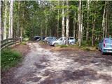
Starting point: Dolina Kot (950 m)
| Latitude/Longitude: | 46,41570°N 13,89770°E |
| |
Walking time: 2 h
Difficulty: partly demanding unmarked way
Elevation gain: 593 m
Elevation difference along the route: 600 m
Map: Triglav 1:25.000
Recommended equipment (summer):
Recommended equipment (winter): ice axe, crampons
Views: 11.844
 | 1 person like this post |
Access to starting point:
We leave the Gorenjska motorway at the Hrušica exit and continue along the road towards Kranjska Gora. Just a little before the village of Dovje, a road branches off to the left from the main road, leading to Mojstrana (Vrata, Kot and Krma). We continue along the road in the direction of the village of Radovna and the Krma and Kot valleys. The relatively steep road then leads us past the TNP sign, after which the road soon levels out and brings us to an intersection, where a gravel road branches off to the right into the Kot valley (straight ahead Radovna and Krma). We then follow this occasionally somewhat poorer road to the parking lot, where we also notice the mountain direction signs.
Route description:
From the parking lot we continue along the wide cart track (poorer road), which after a few minutes of easy walking brings us to the turning point (parking here is not recommended). Here the marked path towards Staničev dom slightly descends and crosses the torrent, but we continue slightly to the right along the cart track, which ascends gently on the right side of the torrent (left bank). After approximately 3 minutes of walking from the turning point, an unmarked hunting path branches off to the right from the cart track, along which we then continue the ascent. The path, which initially ascends gently, quickly brings us to a stream, along which we ascend for a short time before crossing it. On the other side of the stream the path ascends relatively steeply in numerous switchbacks and after some time brings us out of the forest onto quite overgrown grassy slopes. The path from which views open primarily to Macesnovec, Luknja peč and Rjavina higher up again hides into the forest. When the trail brings us to an indistinct side ridge we can in a few steps climb to a nice viewpoint, from which a view opens to the peaks above the Kot and Krma valleys.
On the indistinct ridge the path turns left (not along the ridge) and brings us in a traversing ascent to a smaller grassy scree slope, surrounded by numerous larches. The path then goes back into the forest, higher up turns right and after a somewhat longer traversing ascent brings us to the main ridge, where we continue to the right (sharply left Požgana and Rušnata Mlinarica).
In the continuation we walk along the ridge through the forest for some more time, then the path brings us out of the forest to the panoramic summit of Požar.
Starting point - junction with the marked path 0:05, junction with the marked path - junction on the ridge 1:45, junction on the ridge - Požar 0:10.

Along the route: Odcep z markirane poti (967m), Razpotje na grebenu (1545m)
Photos:
 1
1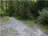 2
2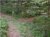 3
3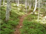 4
4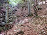 5
5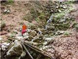 6
6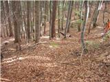 7
7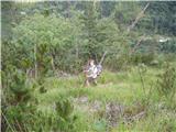 8
8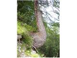 9
9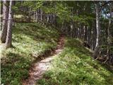 10
10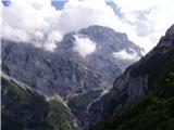 11
11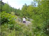 12
12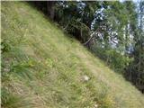 13
13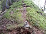 14
14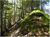 15
15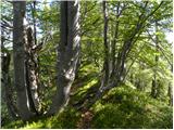 16
16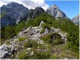 17
17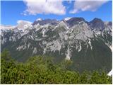 18
18
Discussion about the trip Dolina Kot - Požar
|
| viharnik28. 07. 2011 |
Already a decade ago I hiked up here to Požar from Kot. It was early spring when the ridge was already snow-free, the Škrlatica range still fully snow-covered. The view from here beyond Vrata is unforgettable and unique. The entire range from Stenar to Vrtaški vrh is visible, and along the trail only nature and mountain peace accompany you.
|
|
|
|
| pok luka20. 08. 2011 |
Was today from Kot to Požar and along the ridge to Črna gora and back by road to Legnarjev rovt and I can only say one thing insanely beautiful views as Yiharnik described plus Cmir and Rjavina as on the palm. Whoever wants peace and views I warmly recommend on the whole path we didn't meet a single person except three grouse which will become soup
|
|
|
|
| melitad20. 05. 2012 |
This weekend the hunters probably paid a lot of attention to this path, because from Kot upwards it's nicely widened and the dry brush is nicely broken so it doesn't narrow the trail. But you really have to watch your step, because I encountered two adders, both somewhere in the third third of the path.
|
|
|
|
| Jusk8. 10. 2020 |
The Črna gora ridge has tempted me for a long time, so I decided on this trail today. I started the hike at Kosmačev preval, went through Dolina Kot and continued on the path to Požar. At the beginning a nice trail, then quite steep and narrow with countless switchbacks almost the whole trail you could hear the roaring of Kotovi slapovi, at one point on the trail you can also see one waterfall. Short break at Požar, then along the ridge to the bivouac and down to the starting point. On the way to the bivouac a bit of "fighting" with the scrub, overall the trail is okay also from the bivouac down the trail is mostly well traceable. Regards almost the whole trail you could hear the roaring of Kotovi slapovi, at one point on the trail you can also see one waterfall. Short break at Požar, then along the ridge to the bivouac and down to the starting point. On the way to the bivouac a bit of "fighting" with the scrub, overall the trail is okay also from the bivouac down the trail is mostly well traceable. Regards
|
|
|
|
| ljubitelj gora8. 10. 2020 |
Then we met. Also today late afternoon, only first to Črna gora and then to Požar.
|
|
|
|
| galebka13. 07. 2021 22:42:13 |
The trail to Požar is very difficult in one section due to a large number of fallen trees... There it is extremely hard to follow where the trail is and one quickly loses it from sight while climbing over the fallen trees. And when you're no longer on the trail, you can just blindly bash your knees into the steep slope... I therefore recommend careful observation of the trail or some other destination until these trees are cleared or at least the trail is cleaned (if it ever will be?). Regards
|
|
|
|
| djimuzl14. 07. 2021 18:08:28 |
They certainly won't "clean up" the trees, maybe they'll ease the passage somewhere with a saw.
|
|
|
|
| tango29. 10. 2022 19:15:56 |
We started at Kosmačev preval intending to go to Macesnovec, but the slippery and constantly shady path (at least to the spring) tempted us to the sun-baked ridge from Požar to Črna gora. Right choice, but the descent from Črna gora quite tormented us, as due to fallen leaves the already poorly visible path disappears several times and we, despite having been to Črna gora several times, veered too far right, then it was more scrambling. Also, the road to Kot is smoother than if asphalted and with wonderful weather no wonder the parking at Lengarjev rov was completely full.
|
|
|
|
| BorStenar19. 11. 2022 18:29:21 |
On November 13th I went to Požar via this path.
The path is in good condition, otherwise near the stream in autumn orientation can be difficult (leaves cover the path to the crossing over the stream (which really doesn't exist ) but a well-visible path opens on the other side of the streambed.) Otherwise the tour is super the view even better ) but a well-visible path opens on the other side of the streambed.) Otherwise the tour is super the view even better
|
|
|
|
| G3419. 11. 2022 19:40:15 |
When we went there, there was an excellent view of the surrounding mountains. We didn't see a single person along the entire path
|
|
|
|
| G3420. 11. 2022 16:49:36 |
Sometimes the trail is also exposed but generally it's great.
|
|
|
|
| navdušena22. 06. 2023 09:03:33 |
Has anyone gone on this path this year? How about fallen trees?
|
|
|
|
| BananaBronson22. 06. 2023 09:07:30 |
We hiked it last week. In the middle section there are some fallen trees, but passage is not problematic. I assume you can go around, we modest girls squeezed a bit between them too. The path to Požar from Črna gora is also OK.
|
|
|
|
| navdušena24. 06. 2023 16:06:58 |
Walked the trail today. Fallen trees really aren't a problem. It was very nice!
|
|
|
To post a comment you must log in:
If you do not yet have a username, you must first
register.