Dolina Kot - Rušnata Mlinarica
Starting point: Dolina Kot (950 m)
| Latitude/Longitude: | 46,41570°N 13,89770°E |
| |
Walking time: 3 h
Difficulty: difficult unmarked way
Elevation gain: 827 m
Elevation difference along the route: 935 m
Map: Triglav 1:25.000
Recommended equipment (summer): helmet
Recommended equipment (winter): helmet, ice axe, crampons
Views: 8.319
 | 2 people like this post |
Access to starting point:
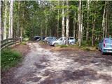
We leave the Gorenjska motorway at the Hrušica exit and continue following the road in the direction of Kranjska Gora. Just a little before the village of Dovje, a road branches off to the left from the main road, which leads to Mojstrana (Vrata, Kot and Krma). We continue following the road in the direction of the village of Radovna and the Krma and Kot valleys. The relatively steep road then leads us past the TNP sign, after which the road soon levels out and brings us to a crossroads, where a gravel road branches off to the right into the Kot valley (straight ahead Radovna and Krma). We then follow this occasionally somewhat poorer road to the parking lot, where we also notice the mountain trail signs.
Route description:
From the parking lot we continue along the wide cart track (poorer road), which after a few minutes of easy walking brings us to the turnaround (parking here is not desired). Here the marked path towards Staničev dom slightly descends and crosses the torrent, we however continue slightly right along the cart track, which ascends gently on the right side of the torrent (left bank). After about 3 minutes of walking from the turnaround an unmarked hunting path branches off to the right from the cart track, along which we then continue the ascent. The path, which initially ascends gently, quickly brings us to a small stream, along which we ascend for a short time and then cross it. On the other side of the stream the path ascends relatively steeply in numerous switchbacks and after some time brings us out of the forest onto quite overgrown grassy slopes. The path from which views open mainly to Macesnovec, Luknja peč and Rjavina higher up again hides in the forest. When the trail brings us to an indistinct side ridge we can in a few steps climb to a beautiful viewpoint, from which a view opens to the peaks above the Kot and Krma valleys.
On the indistinct ridge the path turns left (not along the ridge) and in a traversing ascent brings us to a smaller grassy scree slope, which is surrounded by numerous larches. The path then goes back into the forest, higher up turns right and after a somewhat longer traversing ascent brings us to the main ridge, where we continue sharply left (slightly right Požar).
The path ahead runs along a steep and relatively narrow forest-overgrown ridge, where there is an increased risk of slipping especially when wet. The path, which is not too demanding up to here, then brings us to the foresummit of Rušnata Mlinarica, where less experienced hikers can also end the trip (the summit is recognizable by the large cairn).
We continue along the path on the ridge, which is increasingly overgrown with dwarf pine, but the passages are nice since the dwarf pine is sawn. A little further the path brings us to a shorter steep step, where there is a torn steel cable, where we must climb with the help of dwarf pine for five meters, steeply upwards. The path, which runs along a relatively steep slope and an occasionally narrow ridge then brings us over numerous foresummits and gullies to the bare and panoramic summit of Rušnata Mlinarica.
The path, although not marked, is not particularly difficult orientationally, but in fog it is difficult to know which is the true summit. Technical difficulties on the path occasionally reach the 1st degree of climbing. Due to the crumbly rock, especially in the upper part, it is good to have a helmet. On the ridge when wet there is a great risk of slipping.
Starting point - branch from the marked path 0:05, branch from the marked path - junction on the ridge 1:45, junction on the ridge - Rušnata Mlinarica 1:10.

Along the route: Odcep z markirane poti (967m), Razpotje na grebenu (1545m)
Photos:
 1
1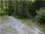 2
2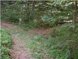 3
3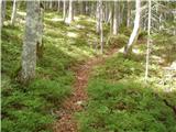 4
4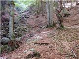 5
5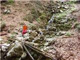 6
6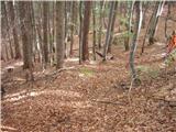 7
7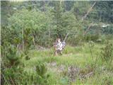 8
8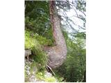 9
9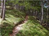 10
10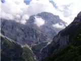 11
11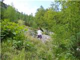 12
12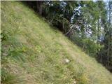 13
13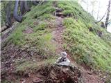 14
14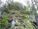 15
15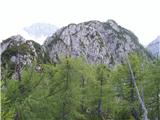 16
16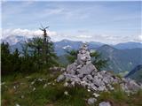 17
17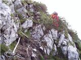 18
18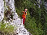 19
19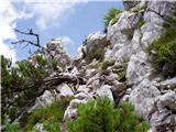 20
20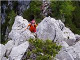 21
21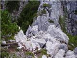 22
22 23
23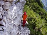 24
24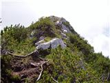 25
25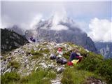 26
26
Discussion about the trip Dolina Kot - Rušnata Mlinarica
|
| Tadej14. 08. 2008 |
An incredibly peaceful place in the embrace of two popular alpine valleys. The ridge between Kot and Vrati offers beautiful views of the highest peaks of the Julian Alps.
|
|
|
|
| katty25. 06. 2012 |
Yes really, and what do you see - on one side Macesnovec, Luknja peč with Vrbanovi špice, and Begunjski vrh, at the head mighty Cmir, then on the right side Škrlatica, Stenar, Planja, and of course Kukova špica  . Worth a visit, but only with knowledge of climbing I and partly also II grade. . Worth a visit, but only with knowledge of climbing I and partly also II grade.
|
|
|
|
| tango3. 11. 2020 |
Ideal day for visiting the solitary ridge above Kot and Vrati. I'm enthusiastic about the beautifully routed path that overcomes quite steep slopes in perfectly drawn switchbacks. Path dry, even the more difficult parts, but on the way back short rope belays were necessary. Nice and incredibly warm day.
|
|
|
To post a comment you must log in:
If you do not yet have a username, you must first
register.