Dolina Krma - Triglav (via Kredarica)
Starting point: Dolina Krma (930 m)
| Latitude/Longitude: | 46,38510°N 13,90710°E |
| |
Route name: via Kredarica
Walking time: 6 h 15 min
Difficulty: very difficult marked way
Elevation gain: 1934 m
Elevation difference along the route: 1985 m
Map: Triglav 1:25.000
Recommended equipment (summer): helmet, self belay set
Recommended equipment (winter): helmet, self belay set, ice axe, crampons
Views: 277.699
 | 6 people like this post |
Access to starting point:
a) Leave the Gorenjska motorway at the Hrušica exit and continue following the road towards Kranjska Gora. Just before the village of Dovje, a road branches left from the main road leading to Mojstrana (Vrata, Kot and Krma). Continue following the road towards the village of Radovna and the Krma and Kot valleys. The relatively steep road then takes us past the TNP sign, after which the road soon levels out and brings us to a junction where a gravel road branches right into the Kot valley. Continue straight on the road, which starts to descend. Midway through the descent, a road branches right into the Krma valley (straight to Radovna). A little further on, we reach the next junction, where we continue right towards Krma. The gravel road then takes us to the Kovinarska koča, which we continue following. The occasionally somewhat rougher road then takes us to the parking lot before the barrier.
b) Drive to Kranjska Gora, then continue driving towards Jesenice. At Dovje, leave the main road and continue right towards Mojstrana and the Vrata, Kot and Krma valleys, following the signs for Krma at the subsequent junctions. The relatively steep road then takes us past the TNP sign, after which the road soon levels out and brings us to a junction where a gravel road branches right into the Kot valley. Continue straight on the road, which starts to descend. Midway through the descent, a road branches right into the Krma valley (straight to Radovna). A little further on, we reach the next junction, where we continue right towards Krma. The gravel road then takes us to the Kovinarska koča, which we continue following. The occasionally somewhat rougher road then takes us to the parking lot before the barrier.
Route description:
From the last parking lot in the Krma Valley, called Pri lesi, continue along the rougher road that continues up the valley and soon brings us to a clearing, where we bypass the nearby building on the left side. Continue along the gravel path that approaches a torrent and crosses it a little further on. On the other side of the torrent, the path enters the forest and first ascends gently, then quite steeply for a while. Higher up, we leave the forest and enter a belt of dwarf pines and shrubs, from the path opening up beautiful views of the nearby cliffs of the peaks, which descend more gently on the other side towards Pokljuka.
Higher up, at an altitude of just over 1400 m, the path levels out temporarily and brings us to the beautiful grassy plain of Vrtača.
After the grassy section, the path begins to ascend again along a path that is often quite slippery in this section, leveling out at the plain of Malo polje.
Here the path turns right and forks.
To the left, a path branches towards Bohinjska vrata and Vodnikov dom on Velem polju, while we continue straight and easily continue along the foot of Vernar to a spring with a trough.
After the trough, the path forks, and we continue straight along the marked path (left unmarked shortcut to planina Zgornja Krma). There follows some moderate, higher up somewhat steeper ascent through sparse, partly larch forest. Higher up, the path turns left and levels out, joined from the left by the aforementioned shortcut.
After the junction of both paths, we quickly reach the shepherd's hut on planina Zgornja Krma, called Prgarca.
From here, the path continues with a moderate ascent to the west, bringing us to the last spring along the path; above the spring, the path forks again.
To the left continues the path over Kurica leading to Konjsko sedlo and further to Dom Planika pod Triglavom, while we go right onto the path leading further towards Kredarica and Staničev dom.
Just a few steps further, from the normal path towards Kredarica, the "old path" towards Kredarica branches left.
Here are the only signs for Kredarica in this direction along the path, while we continue straight along the gentle marked path, which has no signs for Kredarica (September 2025), bringing us a few minutes later to a marked junction where the paths to Kredarica and Staničev dom separate.
Here we go left towards Triglavski dom na Kredarici and Triglav (straight to Dom Valentina Staniča) and first ascend steeply above the plain of Murava, then gradually arrive in the torrent valley called Ulice.
A little further, at Vrh Ulic, the aforementioned quite steep "old path" joins us from the left; another minute further, from the path to Kredarica, a path branches slightly left leading towards Konjsko sedlo (this is a longer variant avoiding the steep ascent over Kurica), while we continue slightly right along the better-trodden path.
The path ahead ascends moderately for a short time mostly northwestwards, i.e., towards the cliffs of Vrh Snežne konte.
In this section, we cross the path Konjsko sedlo - Dom Valentina Staniča, continuing straight and entering the steep scree slopes of Kalvarija. Here we ascend steeply in a few switchbacks along increasingly panoramic slopes.
When higher up the path levels out temporarily, we join the path from Pokljuka leading past Vodnikov dom on Velem polju and over Konjsko sedlo, while we continue slightly right towards Kredarica and Triglav. A few minutes further, when the path levels out even more, a path branches left past Snežna konta and over Štapce towards Dom Planika pod Triglavom, while we continue right, first quite gently, then ascending to the ridge above Vrh Snežne konte, a peak which we saw from below upwards during the ascent over Kalvarija.
Here the path becomes steeper again, and we follow it all the way to Triglavski dom na Kredarici.
In front of the hut, at the chapel of Marija Snežna, the path from Kot valley joins us from the right, leading past Dom Valentina Staniča, while we continue along the left side of the hut, and behind the hut, the path from Vrata valley joins from the right, namely the paths over Prag and Tominškova pot.
We continue left towards Triglav and descend along a technically still undemanding path to Ledeniški preval, from where we begin to ascend towards the cliff of Mali Triglav. Here we follow the marks and the larger mark visible from afar, near which the very demanding path to Triglav begins.
Initially, we ascend a not yet very steep slope with the help of some pegs and individual fixed cables; when we reach the cliff of Mali Triglav, we begin to ascend transversely to the left, where fixed cables were added to the pegs a few years ago, allowing self-belaying with a via ferrata set. There follow some quite steep and exposed ascents, where we must be careful not to slip; on the section with loose stones, we must also be careful not to dislodge stones as this can be deadly dangerous for hikers below us. The path ahead is quite narrow, and with a large number of visitors, congestion can occur due to difficult passing between hikers.
Higher up, the steepness eases, and from the left joins the path from Dom Planika pod Triglavom, namely the path over Mali Triglav, which we reach just a little further.
From Mali Triglav, there follows some gentle descent along an occasionally less exposed ridge; when we begin ascending again, the ridge narrows, and the path becomes precipitous on both sides. Further on, there are some quite steep ascents; the path is mainly well protected with fixed cables and individual pegs, and on nice days, congestion is possible due to passing all the way to the summit. Below the summit, the path becomes less demanding but still precipitous. Just below the summit, a path branches slightly left towards Staničevo zavetišče (emergency bivouac carved into the Triglav massif), while we follow the still cautious but last few meters less steep path to Aljažev stolp, located on the summit of Triglav, the highest peak of the Julian Alps and Slovenia.
Krma - Zgornja Krma 2:30, Zgornja Krma - Kredarica 2:30, Kredarica - Ledeniški preval 0:05, Ledeniški preval - Mali Triglav 0:35, Mali Triglav - Triglav 0:35.
The description refers to the condition in September 2025, the photos are from various periods.

Photos:
 1
1 2
2 3
3 4
4 5
5 6
6 7
7 8
8 9
9 10
10 11
11 12
12 13
13 14
14 15
15 16
16 17
17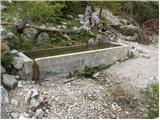 18
18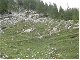 19
19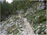 20
20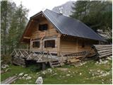 21
21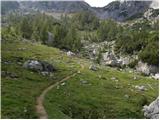 22
22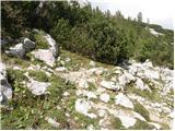 23
23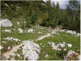 24
24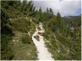 25
25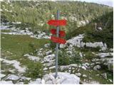 26
26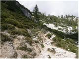 27
27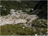 28
28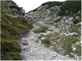 29
29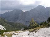 30
30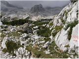 31
31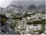 32
32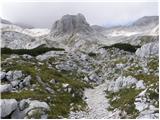 33
33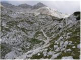 34
34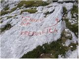 35
35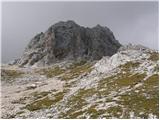 36
36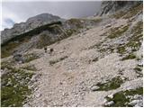 37
37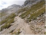 38
38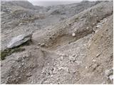 39
39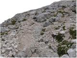 40
40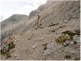 41
41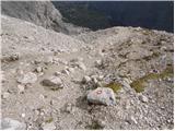 42
42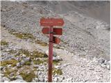 43
43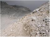 44
44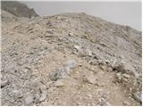 45
45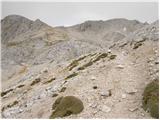 46
46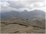 47
47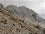 48
48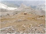 49
49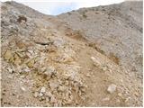 50
50 51
51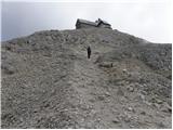 52
52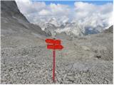 53
53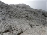 54
54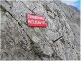 55
55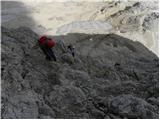 56
56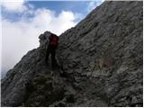 57
57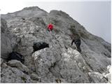 58
58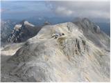 59
59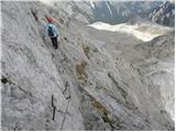 60
60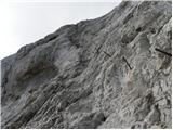 61
61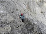 62
62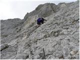 63
63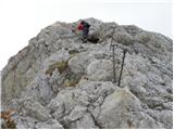 64
64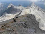 65
65 66
66 67
67 68
68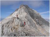 69
69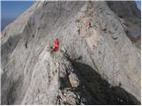 70
70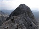 71
71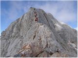 72
72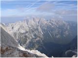 73
73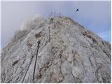 74
74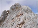 75
75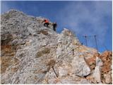 76
76 77
77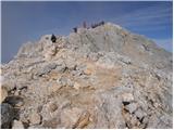 78
78 79
79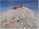 80
80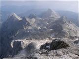 81
81 82
82
Discussion about the trip Dolina Krma - Triglav (via Kredarica)
Show older messages
|
| Gost30. 07. 2007 |
To Kredarica the route is undemanding, so anyone can treat themselves to it. From there on, it's a climbing route and not suitable for everyone. At Zgornja Krma there are plenty of marmots that aren't afraid of people at all, which is a great experience especially for children.
|
|
|
|
| Gost22. 08. 2007 |
and wrapping chocolate in foil
|
|
|
|
| johnybravoslo9. 07. 2008 |
Yes, but they wrap Gorenjka in foil because they are Gorenjci :-)
LP
|
|
|
|
| Nickster21. 07. 2008 |
I saw mice on Kredarica too
|
|
|
|
| sonce320. 08. 2008 |
I'm interested in how much harder the path via Kredarica is compared to the path via Mali Triglav. I have some experience with two-thousanders: Stenar via Sovatno, Razor via Planjo; back via Kriške pode bivak IV-Vrata, Mangart - Italian path, Ojstrica via Mala Ojstrica, Grintavec via Mlinarsko sedlo. I have no issues with fitness, it's mainly about technical difficulty. Thanks for the reply and happy trails!
|
|
|
|
| sam-zee20. 08. 2008 |
sonce, the question is hard to understand - if you mean the ascent to the summit from Kredarica, then the only path is via Mali Triglav, which you climb first, then along the ridge to the summit of Triglav. The path is technically demanding, but given the listed ascents, you won't have problems with it. You can also reach Mali Triglav from Planika, from where the path is much easier in my opinion, so it's often recommended for descent from the summit. Otherwise, there are two more approaches to the summit (one of them also from Planika - I assume this one will suit you), which I don't know. I hope my reply helped 
|
|
|
|
| panda20. 08. 2008 |
From Planika, you can also go via T.škrbina, it is well secured, but there is a lot of loose scree on the slabs, so be careful.
|
|
|
|
| srpanj10. 07. 2009 |
Could someone tell me - is there snow on the path from Krma to Kredarica, what equipment is needed?
I'd go this or next weekend
|
|
|
|
| Bojan_A18. 08. 2010 |
Today I thought of doing a training run to Kredarica. The weather in the morning wasn't promising at all, but I thought it would hold. It didn't. It was drizzling all the time, and the fog was getting thicker and thicker, so thick that I thought I was lost. I was running just a few meters from the shepherd's stand in Zg. Krma but couldn't see it. Only at the trough above the hut did I realize I hadn't strayed. The running speed was therefore below plan. On Konjski preval it started blowing hard. So I decided to turn back. It was quite cold, good thing I had gloves.
The descent to the valley was pleasant, as I met a certain hut girl unusually willing to run and we then slowly ran together to Lesa.
The goal wasn't reached, but I'm still satisfied because I got away without injuries.
|
|
|
|
| vik18. 08. 2010 |
Bojan, tomorrow we plan the same route as you today. And to the top. Probably similar, so bad. Question, does it make sense?
|
|
|
|
| Bojan_A18. 08. 2010 |
The forecast is practically identical, but with forecasts it's always like this - if it's a bit better than forecasted, it can be great for hiking, if a bit worse, it can be desperate. With proper equipment and good route knowledge, you can still reach Kredarica. However, I would rather postpone for a day. It really makes no sense (unless necessary) to push up there in total fog and rain. Improvement is forecast for Saturday.
|
|
|
|
| vik19. 08. 2010 |
Thanks, we didn't go. Next time. Although the camera now shows blue sky at Kredarica
but fog below, but it can only be like the one you had. Best regards
|
|
|
|
| Bojan_A19. 08. 2010 |
Exactly as I said happened: the weather was a bit better than forecast and in my opinion perfect for hiking, because it wouldn't be hot.
I'm also sorry I didn't move my training to today.
I hope you're not too angry. 
Best regards, Bojan
|
|
|
|
| vik19. 08. 2010 |
Where then. Next time or somewhere else.
Now the last two times it was already better than forecast - last Škrlatica, a good week ago Bohinj, Komna, Bogatin, Vrh Veliki Peski, Batognica, Krn, Krn.jezero, Velika Mantura, Velika Baba, Lanževica, Lepa Komna, Bohinj. Long.
Maybe Saturday, Sunday somewhere.
Best regards Vik
|
|
|
|
| Bojan_A19. 08. 2010 |
Well, the fact is that weather forecasters often "screw you over": either you stay in the valley despite good weather or they soak your hike despite predicted good weather
|
|
|
|
| Alti8. 09. 2010 |
Is the path to Triglav from Dolina Krma really that much shorter than from the end of the road on Pokljuka? The GPS track from Krma is only 8 km long, from Pokljuka I drew it myself and it's almost 12 km. I don't understand how it could be approximately the same walking time?
|
|
|
|
| IgorZlodej8. 09. 2010 |
To me, from Krma it's already shorter by sight, as the path is more direct. From Pokljuka, even from the parking under Konjščica, it drags on quite a bit. Especially from Studorski preval under Tosc to Vodnikov dom, where it even goes slightly downhill. Of course from Krma it's also substantially shorter time-wise, which depends on how fast you hike. Apparently times aren't very welcome to mention much here, because it quickly comes off as self-praise, of course by those who mainly enjoy the mountains (5-10 times a year).
|
|
|
|
| Gorazd G8. 09. 2010 |
Alti, have you thought about the relative elevation difference on both paths?
The starting height on Pokljuka is quite a bit higher than in Krma. You probably agree that it is not the same whether you walk a significant part of the path flat (even slightly downhill) versus constantly uphill.
What I want to say is that for the duration time of a certain tour, other factors must be considered (elevation difference, path difficulty etc.), not just the path length you get from GPS.
|
|
|
|
| zabica8. 09. 2010 |
True that the starting point on Pokljuka is 300 meters higher than from Krma, but you walk so much longer that it definitely doesn't pay off. The path from Krma is somewhat steep, but no big deal (last time I went up - 14 days ago - three kids in front of me managed it easily), with normal pace you're at Kredarica in 4 hours. From Pokljuka that's not possible.
|
|
|
|
| zabica8. 09. 2010 |
Mulc, you're not someone normal hikers would compare themselves to!!
|
|
|
|
| pikec18. 09. 2010 |
it's possible, zabica. It's not a steep path at all, it's a completely easy normal path. Only in winter when trudging through snow it's not possible
|
|
|
|
| sh8. 09. 2010 |
According to my experience you cover 300 vertical meters in one hour if walking at a moderate pace. From Pokljuka you can also easily reach Kredarica in 4 hours, since on flat terrain you can walk quite fast. Of course you shouldn't have too large a group with you, as that greatly extends the time.
|
|
|
|
| viharnik8. 09. 2010 |
However you look at it, Igor is mostly right. The path from the parking lot below Konjščica to Kredarica really drags on. Here you cover quite a few more km than from Krma, the path is gentler, so faster steps if you have fitness. Conversely, the seemingly easier walk from Pokljuka is tiring for occasional hikers due to more steps on the path. Kredarica is reached from both directions in four hours if from Pokljuka you can speed up the pace.
|
|
|
|
| gorjanci13. 08. 2011 |
I have already been to Mangart. 1995, nothing since. I have hiked quite a few peaks over 2000m. Cmir, Škrlatica, Špik, Razor, Vrbanova špica, Turska gora, Grintovec, Skuta......all until around 1997. Then with the kids we went to lower, more rounded and forested peaks. This year intensively 2x a month we go to the mountains and prepare for Triglav. We are increasing the difficulty of peak accesses. I'm interested in what you suggest for Mangart. I have no "terrible" memory, but at 22 nothing seemed difficult to me. Today I have two children and a husband who, except for this year's ascents, has no 2000ers behind him.
|
|
|
|
| mary22. 09. 2011 |
Hello!
On Saturday or Sunday I'm heading to Triglav via Kredarica. I'm interested if there's still any snow or ice left on this shady side from last week when apparently some snow fell? Thanks
|
|
|
|
| ljubitelj gora2. 10. 2011 |
Descended via this trail from the summit, for the whole endeavor less than 6 hours, up via Škrbina and down to Kredarica, three pitons missing to Kredarica, rocks a bit smooth, so every additional piton welcome, trail steep and very demanding. At Kredarica only a few people, take pics and head to Krma.
|
|
|
|
| DD8. 01. 2012 |
hi. today at 16:00 we found Black Diamond hiking poles at the parking lot in Krma, they were next to my car, owner please contact me at 040/828-698.
best regards
|
|
|
|
| DD29. 03. 2012 |
Today I visited our highest mountain, it was nice, conditions are so-so, snow sinks even to your ass, the path from Kredarica to the summit is some kind of mix of everything from ice to scrambling on rocks and there was no shortage of soft unconsolidated snow either, winter gear is mandatory.
lp
|
|
|
|
| mtjkristan1. 04. 2012 |
yesterday, on the last day of March we went with the group on a night hike to Kredarica. The trail is trodden, but in the night hours quite icy (crampons). Some of us wanted to ascend to the summit, but strong gusts of wind prevented us and we turned back instead and returned to the shelter of the Kredarica hut. A little more "debate" and in the sunny day return towards Krma. Nice day, good company,... best regards
|
|
|
|
| teja8824. 08. 2012 |
hey. I've also decided it's about time to head to our little father. I'm wondering if it's possible or safe to go to Kredarica in hiking shoes, only from there up in proper mountaineering boots. I have big problems with blisters on my heel, despite broken-in boots and everything that goes with it... thanks in advance for your answer. lp
|
|
|
|
| spyderskidoo24. 08. 2012 |
from Krma to Kredarica yes...then up definitely proper shoes
|
|
|
|
| GregorC25. 08. 2012 |
teja88 try applying Hansaplast foot expert cream to your heels before the hike. It helps me
|
|
|
|
| gregorp25. 08. 2012 |
Teja88 if your shoes blister your heels, they have a solution at this address: http://www.informacija.net/cevljarstvo-stivale (hope you're near Ljubljana). I had similar problems (after about 1 hour of walking on steeper terrain), now they're fixed. Check it out, you won't regret it. And comfortable steps!
|
|
|
|
| Grega9215. 11. 2012 |
Hi
I'm wondering if it's possible in winter to Triglav via the secured path (from Kredarica, like in summer)
with proper equipment
or if there's another path
|
|
|
|
| ljubitelj gora15. 11. 2012 |
Yes, there's also another access if there's enough snow, you exit between Mali Triglav and Triglav, but more or less you go from Kredarica where the summer path goes.
|
|
|
|
| sasajo13. 08. 2013 |
Is there still snow on the path as I'm setting off to Triglav on 24 August.
|
|
|
|
| andrej7814. 08. 2013 |
No snow, or rather it is not problematic...
|
|
|
|
| sasajo14. 08. 2013 |
Thanks for the information
|
|
|
|
| Krepkonogi Gams17. 10. 2013 |
Does anyone know if the snow on the way to the summit is problematic?
|
|
|
|
| MaxSi18. 10. 2013 |
Conditions as of 17.10.2013
The snow line is somewhere above 2000m. No issues to Kredarica from Krma side, little snow, so no special gear needed to Kredarica. From Vrata side, snow line starts right after the junction of the path via Prag and Tominškova. The path from there is icy all morning (possibly all day), in places it collapses deeply, approach from this side recommended only to those not troubled by such paths. At least poles and good boots needed, simpler crampons are advisable.
Ascent to the summit is fully winter! Full winter gear required, crampons and ice axe!
Happy trails.
|
|
|
|
| MaxSi18. 10. 2013 |
A trifle. It's definitely better to know than to have some mishaps occur 
|
|
|
|
| Cuco11. 07. 2014 |
Hi!
Could someone who was there recently or who plans to go to Triglav (not necessarily from this direction - Krma) please write how the snow conditions are.
Do you think it would be safe to reach the summit weekend 19-20.07? To Kredarica probably no problem or am I wrong?
Thanks a lot!
Mitja
|
|
|
|
| patrik5. 02. 2015 |
hi!
for the second week I've been thinking of going to Triglav this way... has anyone been there these days and can you go up?
|
|
|
|
| jax5. 02. 2015 |
These days the weather is very bad, a lot of new snow is forecast, avalanche danger is quite high.
Now, as things stand, from the weekend onwards the weather will improve and the danger will slowly decrease. There is a possibility that it will be okay for Triglav next week or at least next weekend, but in any case follow the reports.
|
|
|
|
| kuzmanb4. 07. 2017 |
On 3.7.2017 we went to Triglav from Krma via Kredarica, back via Planika. There are still quite a few snow patches around the summit, but the path is dry with no special problems, though some prior experience is needed for the ascent via fixed cables from Kredarica. From the parking lot in Krma we started at 5:30, reached the summit at 12:00 with short stops, ate lunch in the hut and returned at 19:00. Weather was very changeable with sun, clouds and two showers, but at least not very hot. In case of sun, recommend starting an hour earlier. Ascent and descent almost 2000m, so legs suffered a lot, especially knees. For average hiker, two-day tour probably better, but the path is beautiful and day well spent.
|
|
|
|
| slamca30. 07. 2017 |
Hello!
I'm wondering if the road to Krma is normally drivable by car, or if the recent rain has damaged it badly?
Thanks for honest answers.
|
|
|
|
| slamca2. 08. 2017 |
It seems that in these days no one has set off from Krma towards Triglav. Let me tell you that the road is excellent and passable without any problems despite the abundant rains.
|
|
|
|
| Prleki28. 08. 2017 |
Hello!
We're not really hikers. But we still decided (me, daughter and younger son) to head to TRIGLAV.
Departure in the morning at 6.00 from the parking in Krma, via Kredarica to Triglav, and back the same way.
I tell you: UNFORGETTABLE ADVENTURE
(Especially for us who viewed the top of Pohorje with the help of a gondola)
Back to parking at 20.30
I just want to say: WHERE THERE'S A WILL, THERE'S A WAY
|
|
|
|
| Chaos12316. 06. 2018 |
Today from Krma to Triglav. I walked the path normally without winter gear... except 2 snow patches on Mali polje and later after the junction to Konjsko sedlo (those two are unproblematic) and snowfield on the left side of Vrh Snežne Konte (that one also passable normally without crampons and ice axe) no snow on the path. LP
|
|
|
|
| Marecar1. 01. 2020 |
Exceptionally beautiful New Year's day 1.1.2020. No clouds and huge number of people. Most of them celebrated New Year's Eve at the top and at Kredarica. The cold wasn't overwhelming (-4). The wind wasn't hurricane-like either. To Kredarica it's so well trodden that you can get there even with mini crampons. To Mali Triglav is another story. An excellent track is made, but you still need to climb with caution (one mistake, and you're in a snow hole). From Mali Triglav to Aljažev stolp it's easy... The sunrise was perfect.
Best regards to all mountain and nature lovers in general...
|
|
|
|
| Turbolazec19. 04. 2020 |
Hi! I'm interested in the conditions for Triglav on this path, if anyone went recently? Thanks and best regards
|
|
|
|
| snezzzinka4. 08. 2020 |
On 27. 7. we were in Dolina Krma; somewhere from Kovinarskega doma to Bohinjska vrata we lost our sunglasses. We will be very grateful to the finder.
|
|
|
|
| recruit18. 12. 2020 |
Interesting video! How long does it take from Kredarica to the summit with average pace?
|
|
|
|
| tomo_kugy19. 12. 2020 |
@recruit
I think it's marked 1 hour and a quarter. But it depends on several factors:
- if you ascend after a multi-hour path from the valley, you'll likely need a few more minutes than if you start in the morning after sleeping at Kredarica
- average hiker covers approx. 350 vertical meters per hour, which is almost exactly the elevation difference between Kredarica and the summit
- the biggest factor is the crowd. Midweek in September there are far fewer people than weekend mid-August.
My opinion is that with average pace without crowd you should easily manage the path in one hour.
|
|
|
|
| recruit25. 12. 2020 |
@tomo_kugy
Thanks for the detailed response!
|
|
|
|
| Kafetarca11. 07. 2021 21:02:19 |
How is the road to the starting point in Krma?
|
|
|
|
| jbs11. 07. 2021 21:12:59 |
As always, passable for a normal car, otherwise quite damaged in some places by stormwater...
|
|
|
|
| coupet24. 08. 2021 19:56:10 |
Up to where can one drive with a car?
I saw that some have already received fines.
Thanks, regards
|
|
|
|
| trdi25. 08. 2021 08:45:45 |
You can drive up to the woods, but you have to park strictly only around the parking sign. Everyone who parks on the nearby meadow gets a 500 EUR fine....
|
|
|
|
| Davidd29. 12. 2021 16:10:23 |
Does anyone know what the road to the starting point is like, is it passable? Due to snow.
|
|
|
|
| Grenaleva30. 12. 2021 16:30:40 |
For Christmas they said it was plowed a little before Kovinarska koča, there was parking for 3 cars
|
|
|
|
| jbs30. 12. 2021 19:51:39 |
It is plowed to less than a kilometer before Kovinarska, to the ramp and the sign Planina spodnja Krma. There are about 12 cleared parking spaces, but meeting and turning is almost impossible. Considering you only gain less than two kilometers or 20 minutes, it's not worth it. The landowners obviously don't like driving either, as today at Pocarja the road was "closed" with tape. It's also hard to find parking at Pocarja. Tomorrow and over the weekend it will probably be madness. Otherwise, the path to Kredarica is very nicely reinforced and trodden, so it will be until the next snowfall.
|
|
|
|
| Davidd31. 12. 2021 08:44:37 |
Thanks. How about the path to the starting point from Vrata, and the road at the end of Pokljuka?
|
|
|
|
| Engis8. 08. 2022 14:26:46 |
Hello, does anyone know how parking is at the starting point from Krma (end of the road at the barrier)? And what's the condition of the road? Heavily rutted or ok for a personal car? Thanks!
|
|
|
|
| ŠpRo298. 08. 2022 14:45:27 |
The road is ok, plenty of parking spaces, park on the marked spots. Good luck.
|
|
|
|
| Engis8. 08. 2022 14:48:39 |
Thanks for the quick reply!!
|
|
|
|
| Zvončica53. 07. 2023 14:47:27 |
Hi. I'm wondering which route has more fixed cables and thus self-belaying options - from Kredarica or from Planika?
|
|
|
|
| B23. 07. 2023 15:23:42 |
There are more cables and pegs on the section Kredarica - Mali Triglav, where the paths from Planika and Kredarica meet.
|
|
|
|
| Sifra20. 07. 2023 16:15:18 |
Hi,
Does anyone know if the path through Dolina Krma to Kovinarski dom is open and drivable by car? Thanks!
|
|
|
|
| turbo20. 07. 2023 16:58:41 |
|
|
|
|
| Sifra20. 07. 2023 17:42:40 |
Thanks to both. I've seen it, yes. On Monday we plan to go from Krma to Triglav and hope it will be possible. Is there any option from there?
|
|
|
|
| turbo20. 07. 2023 17:50:30 |
Maybe Pokljuka-Vodnikov dom and onwards . . .
|
|
|
|
| Sifra21. 07. 2023 15:23:47 |
Thanks, it looks like we'll have to go this way then.
|
|
|
|
| mofoslo9. 08. 2023 07:46:57 |
Hi, I'm in a group of 15 people where this Saturday slot has been reserved for half a year. Krma Kredarica Triglav Saturday/Sunday (12/13.8.).
Due to floods 2 said no, due to the strange weather this summer another 2. 10 are for it. I as the 11th am very skeptical... and I'm 99% for no. I just need that 1%. How is Krma anyway? Kredarica Hut says it's still full, same for Planika. Media are publishing not to go to the mountains. I want to go myself but taking risks to cause problems, of course unplanned troubles but still right this weekend.. is a bit too selfish for my taste or am I just exaggerating?
|
|
|
|
| julika9. 08. 2023 08:34:11 |
Since you already mention Krma (+ Radovna and Kot), there is a complete closure due to works after the storm.. Already here with your presence you endanger yourself and disturb or delay those carrying out intervention works
|
|
|
|
| ppegan9. 08. 2023 08:38:44 |
If I'm not mistaken, both Kot and Krma are still closed Let someone correct me if I'm wrong ... In this case it definitely won't be possible from this starting point.
Currently in the mountains mostly foreigners, I learned from conversations with several caretakers who are not bothered by our floods. They don't even know that anything happened or is happening. They came on vacation, booked sleeping in huts in advance and come anyway regardless of the weather. Mostly only foreigners are being rescued - again because they don't know what's happening in the country and that by foolishly venturing into the mountains they additionally burden the already overburdened mountain rescuers. One could say they don't give a damn about anything 
|
|
|
|
| vajngero4. 09. 2023 10:50:18 |
The road is still officially closed, but you can drive past the barrier. The road is a bit worse.
|
|
|
|
| mofoslo19. 09. 2023 12:00:08 |
Maybe someone knows how conditions are this weekend? Saturday up? Thanks. Interested in Krma's state and weather opinion (for clairvoyants).
|
|
|
|
| Janez Seliškar19. 09. 2023 13:12:30 |
For a more pleasant tour, at least two limitations: closed road to Krma and bad weather. Otherwise, path underfoot and cheerfully upwards.
|
|
|
|
| renko27. 05. 2025 17:02:21 |
for the weekend I plan to go to Triglav. Since it's my first time to Triglav in spring/winter conditions I'd ask for a suggestion whether it's better via Kredarica or Planika
|
|
|
|
| mkaay17. 06. 2025 09:48:53 |
Hi, I'm interested in conditions for Triglav and recommended gear, ice axe crampons or is most of it dry already. Thanks
|
|
|
|
| Nehodimvhribe17. 06. 2025 12:23:13 |
Via Krma all dry, for gear take enough fluids and good mood with you
On Saturday there was still a minimal snow section right before entry into the secured climbing part, but I'd say even there it's all gone now
https://postimg.cc/2VKTBkL1
|
|
|
|
| uros44421. 06. 2025 13:52:47 |
I assume the road is open and functional?
|
|
|
|
| uros44421. 06. 2025 18:28:46 |
Just when you were there today Matej. Does the watering place on the path have any water?
|
|
|
|
| jbs21. 06. 2025 19:05:03 |
Currently no water flowing in the gullies below and above Prgarca...
|
|
|
|
| matej71222. 06. 2025 15:15:52 |
The gullies are unfortunately dry:/
|
|
|
To post a comment you must log in:
If you do not yet have a username, you must first
register.