Tinčkova koča - Dom pri izviru Završnice
Starting point: Tinčkova koča (1070 m)
| Latitude/Longitude: | 46,42280°N 14,19910°E |
| |
Walking time: 1 h
Difficulty: easy marked way
Elevation gain: 355 m
Elevation difference along the route: 355 m
Map: Karavanke - osrednji del 1:50.000
Recommended equipment (summer):
Recommended equipment (winter):
Views: 65.509
 | 2 people like this post |
Access to starting point:
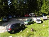
From the motorway Ljubljana - Jesenice take the Lesce exit and follow the road ahead in the direction of Žirovnica and Jesenice. After a few km of driving, we arrive at a crossroads, where the road to Žirovnica and Moste branches off to the right (from the direction of Jesenice left). Only a few meters ahead, at the next crossroads, we turn left to Moste (right Žirovnica). Further, we drive past a monument to fallen soldiers, where the road starts ascending the hill under the railway track. At the top of the slope we turn right (at the sign Vila Karin), but we continue ahead towards Završniško jezero and Valvasorjev dom. The road then flattens and brings us to a crossroads, where the road towards Valvasorjev dom branches off to the left, and we continue straight on the initially still asphalted road. The road soon becomes macadam, and we follow it to the parking lot near Tinčkova koča. The road in the upper part is often in quite bad condition.
Route description:
From the parking lot at Tinčkova koča we continue on a wide rocky cart track in the direction of Koča pri izviru Završnice. Already after a few steps of walking the blazes direct us slightly right onto a somewhat steeper footpath, which ascends across a panoramic grassy slope, then returns to the previously mentioned cart track, which we follow to the right. The cart track, which ascends relatively steeply through the forest, brings us after a few minutes of further walking to a grazing fence, behind which we arrive at the marked junction.
We continue straight (slightly right Roblekov dom) on the still rocky cart track, which higher brings us out of the forest onto expansive grassy slopes of Smokuška planina. Here the steepness eases and the increasingly panoramic path brings us to Koča pri izviru Završnice in 15 minutes of further walking.
Photos:
 1
1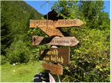 2
2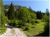 3
3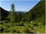 4
4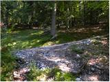 5
5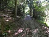 6
6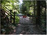 7
7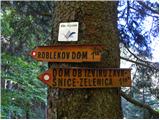 8
8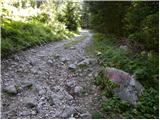 9
9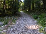 10
10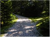 11
11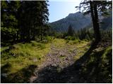 12
12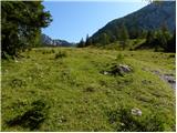 13
13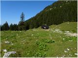 14
14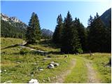 15
15 16
16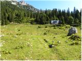 17
17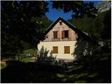 18
18
Discussion about the trip Tinčkova koča - Dom pri izviru Završnice
|
| m.b.26. 07. 2011 |
Today my daughter and I visited the hut at the source of Završnica. We started below the sawmill or at the NOB monument. The path to Tinčkova koča is very nice. The stone road, which then continues, requires more careful walking. After half an hour on the road we reach the pasture where livestock grazes. We cross the pasture and we're already at the hut . The hut is open and will be open in August and September too. The caretakers warmly welcomed us and served excellent goulash. Thanks! . The hut is open and will be open in August and September too. The caretakers warmly welcomed us and served excellent goulash. Thanks!
The weather was favorable to us and we returned to the valley in sunshine and very satisfied.
|
|
|
|
| milossmit8. 09. 2011 |
Yesterday my friend and I arrived from the top of Begunjščica via scree to the hut at the source of Završnica, where we treated ourselves to barley soup and sausage and I must say that I haven't tasted such excellent barley soup and tasty sausages this year in any mountain hut. All praise to the caretakers and cook, who obviously do their job with the greatest pleasure.
|
|
|
|
| Pohodnica567. 10. 2012 |
I too was quite surprised yesterday that it was closed. Continued to Zelenica, where there were crowds of people. Met quite a few hikers on the way who extended from Zelenica to this otherwise pleasant hut, from which there is a great view of Vrtača. Too bad.
|
|
|
|
| slavkoo6. 09. 2014 |
Anyone know? Is the time from Roblekov dom to Dom na Zelenici approx the same as descending from Roblekov dom to Tinčkova koča then at junction turn right to Koča pri izviru Završnice and on to Dom na Zelenici? Probably safer and easier than the first, right?
|
|
|
|
| sirt16. 09. 2014 |
Definitely the first path is shorter, nicer, more scenic. On the second path you descend ~450m immediately and then ascend slowly. On the first you ascend ~200m and then descend slowly towards Zelenica. That little cable is not demanding at all. Across the scree with normal caution and poles it's also not dangerous. For me the easier path. But this is purely subjective. The decision is yours.
Good luck
|
|
|
|
| slavkoo7. 09. 2014 |
Thanks sirt1, I'm off....
|
|
|
|
| plejade4510. 08. 2015 |
The caretakers are friendly and fun. Pleasant and clean hut.
|
|
|
|
| zgonik17. 08. 2015 |
With a group of friends I spent 4 wonderful days in the Karavanks. We ascended Vrtača, Begunjščica and Stol. Our base was Koča pri izviru Završnice. From the bottom of my heart I thank the caretakers Marina and Sabina for their positivity and kindness as well as excellent food. I would also praise the comfortable beds and aesthetics, which is usually a weak point in mountain huts.
|
|
|
|
| antistres17. 08. 2015 |
With company I spent four days in the embrace of the Karavanks. Starting point for ascents to Stol, Begunjščica and Vrtača was DOM PRI IZVIRU ZAVRŠNICE. Such a pleasant environment was complemented by friendly caretakers, an exemplary maintained hut, food lovingly prepared and really good water. Sincere thanks to the caretakers! I recommend it to lovers of our mountains  !! !!
|
|
|
|
| Kranj18. 08. 2015 |
Antistres, how much did you pay for the overnight stay? lp
|
|
|
|
| Rokovnjacica2. 07. 2016 |
Yesterday I was at the source of the Završnica river. The friendly caretakers in the hut still prepared excellent buckwheat pancakes. The path from Tinčkova koča to Smokuška planina is in the shade all the time. The view from the source to Lake Bled thrilled me.
|
|
|
|
| Majdag3. 01. 2019 |
Završnica - Tinčkova koča....In the morning there was a large spruce a little from the Zavrh guesthouse across the road. Impossible to go further by car.
|
|
|
|
| navdušena5. 05. 2020 |
Does anyone know what the condition of the road to Tinčkova koča is?
|
|
|
|
| magnolija662. 08. 2020 |
Same question about the road to Tinčkova koča. What is its condition?
|
|
|
|
| MaticP26. 02. 2024 11:24:40 |
Hello! Does anyone know the condition of the road to Tinčkova koča? Thanks.
|
|
|
|
| PUHIPUHI19. 06. 2024 16:58:32 |
Currently, the road to Tinčkova koča is in excellent condition.
|
|
|
|
| Deja6610. 08. 2024 18:36:12 |
Hello, is the path shady or is it better to set off when it cools down - in autumn?
|
|
|
|
| rensul10. 08. 2024 21:25:13 |
Deja66--Two thirds of the path go through the forest, then you reach the alpine pasture and there is no shade.
|
|
|
|
| Daaam11. 08. 2024 10:02:25 |
Actually it's an easy hike if going only to the hut. Even the last third of the path in the sun isn't very steep so if you're at least a bit 'fit' you don't need to wait for autumn. Nice up there. Go for it boldly.
|
|
|
|
| Vrhovka20. 10. 2025 18:54:37 |
Hello. Does anyone know the condition of the road? Has anyone been in these parts recently?
|
|
|
|
| tomjan21. 12. 2025 18:46:13 |
Does anyone know the condition of the road to Tinčkova koča?
|
|
|
|
| obergutman3. 12. 2025 10:45:18 |
tomjan2
On Friday 28.11. it was normally drivable with a passenger car, just over the water channels you need to drive more slowly and carefully.
|
|
|
|
| rensul30. 04. 2026 21:57:45 |
Today 30.4. 2026, ramp lowered(7€), road fixed up, I don't know if it was ever so smooth, the last slope below Tinčkova koča is asphalted, in short, if they already know how to charge, at least they do something
|
|
|
To post a comment you must log in:
If you do not yet have a username, you must first
register.