Starting point: Trdnjava Kluže (525 m)
| Latitude/Longitude: | 46,36120°N 13,58930°E |
| |
Walking time: 5 h
Difficulty: difficult marked way
Elevation gain: 1683 m
Elevation difference along the route: 1683 m
Map: Julijske Alpe - zahodni del 1:50.000
Recommended equipment (summer): helmet, lamp
Recommended equipment (winter): helmet, ice axe, crampons, lamp
Views: 194.711
 | 7 people like this post |
Access to starting point:
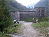
From Bovec, we drive towards the Predel border crossing. After a few kilometres along the road, we notice the Kluže Fortress and the parking lot next to it, where we park.
Route description:
From the parking lot, head to the wide path located on the opposite side of the road from the Kluže Fortress. The path, which rises barely noticeably, leads us after a few minutes of walking to a military tunnel. Since the tunnel is quite long, a headlamp or other light will be helpful. After the tunnel, the path brings us to a junction where we continue left towards Na Robu and Point 1313. The path then steeply ascends for a short time, then continues in a gentle traverse with some views towards the Kluže Fortress. After about 25 minutes of walking, the path leads us to the mighty ruins of Hermann Fort.
From the fort, continue right towards Rombon on the path that steeply ascends through the forest upwards. At junctions, continue on the marked path or follow the signs for Na Robu, higher up only the signs for 1313. After a good two hours of walking, the path leads us to a beautiful vantage point where a view opens towards nearby Jerebica and other mountains above the Koritnica valley. The path then goes back into the forest and leads us to a junction of two paths: left leads to Point 1313, straight ahead to Rombon.
Head straight on the path towards Rombon and faithfully follow the markers. The steepness of the path soon eases and the path leads us out of the forest, where a beautiful view opens onto the Bovec basin and the mountains above it. Until now, the nice and well-trodden path becomes barely visible further on. The path ahead leads across grassy slopes along a less noticeable trail, where the markers are of great help for easier orientation. A crossing of a short strip of forest follows, then the path begins to ascend the slope overgrown with dwarf pines.
Here the trail leads us to an old military mule track, which we follow onwards. The increasingly scenic path then leads us to the next military fortifications (Point 1313 / Na Robu). On this section, the path runs directly between the walls of the ruins. The path is exceptionally well marked here, so we cannot get lost in the labyrinth of former military objects. The path then ascends for some time along the mule track, then turns left onto grassy slopes. In a moderate ascent, we cross occasionally somewhat steeper grassy slopes, where there is a great risk of slipping especially when wet.
The path further leads us into a small, indistinct valley, up which we ascend to an indistinct saddle. Here, a path from Bovec, or the hamlet of Zavrzelno, joins from the left. We continue right on the path that steeply ascends over a short step. With the help of natural holds, we climb one level higher (about 5 meters). Great caution is required at this point, especially on descent! The path then levels out and continues along the moderately steep summit slope of the mountain. We follow this increasingly scenic path all the way to the summit of Rombon itself, from which an exceptional view opens onto the Julian Alps, especially the mountains above the Soča Valley.
Kluže Fortress - Hermann Fort 0:25, Hermann Fort - junction before Point 1313 1:50, junction before Point 1313 - Naklo 2:05, Naklo - Rombon 0:40.

Photos:
 1
1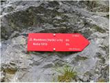 2
2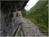 3
3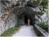 4
4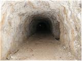 5
5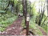 6
6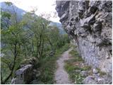 7
7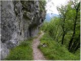 8
8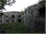 9
9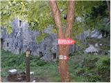 10
10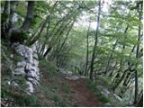 11
11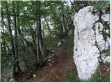 12
12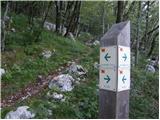 13
13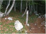 14
14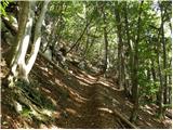 15
15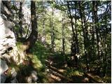 16
16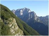 17
17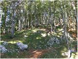 18
18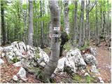 19
19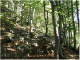 20
20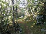 21
21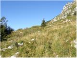 22
22 23
23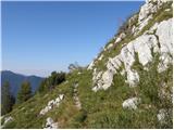 24
24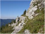 25
25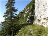 26
26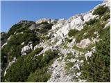 27
27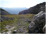 28
28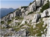 29
29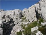 30
30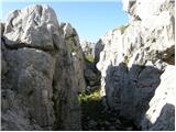 31
31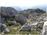 32
32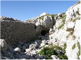 33
33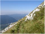 34
34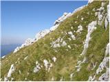 35
35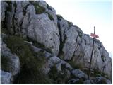 36
36 37
37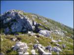 38
38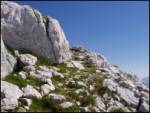 39
39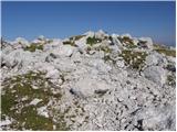 40
40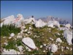 41
41
Discussion about the trip Trdnjava Kluže - Rombon
Show older messages
|
| Gost24. 09. 2007 |
This mountain hike is very nice. The path is nice and well marked. For viewing the upper military fortifications, it's worth taking some time. On this path you won't meet many people, so it's suitable for those who don't like crowds in the hills.
|
|
|
|
| franc anzelak10. 03. 2008 |
Walked 2x, now marked, very nice and interesting. To also be pleasant requires quite some fitness. 
|
|
|
|
| wida10. 03. 2008 |
In summer when the sun bakes I do not recommend visiting Rombon.
|
|
|
|
| Biser gora10. 03. 2008 |
If we start the ascent very early in the morning even a hot day is no obstacle. Last year I went up from Bovec sunbathed a bit at the top then went to the cable car at Kanin which brought me back to Bovec. That way I avoided the heat awaiting me on the hot southern slopes.
|
|
|
|
| SPIDER10. 03. 2008 |
How long did it take you to hike from the top to the cable car?
|
|
|
|
| Biser gora10. 03. 2008 |
If I remember correctly, just under 4 hours. But it's a nice scenic path. If you have time, you can also climb to Črnelska špica.
|
|
|
|
| larix decidua23. 05. 2008 |
I'm interested in the current conditions on Rombon.. Is winter gear still needed?
Best regards
|
|
|
|
| Timy28. 05. 2008 |
I'm interested in a comparison of the paths to Rombon from Bovec (Za Vrzelno) and this one from Trdnjava Kluže, specifically which one is more interesting. I went from Bovec last year and wasn't too enthusiastic (from Kluže it wasn't marked yet then). LP
|
|
|
|
| Tadej28. 05. 2008 |
As for military fortifications and caverns, the path from Trdnjava Kluže is much more interesting than from Bovec. It's worth making a short detour in the direction of "Na Robu 1313", where there are many military fortifications. More about the Soča Front http://prohereditate.com/sl/
|
|
|
|
| birch31. 05. 2009 |
for passing through the tunnel you no longer need a flashlight, because they have equipped everything with lights and therefore the path is now more pleasant. If you stop at the fortress, also check out the CASTLE FOUNTAIN, which is now also on display.
|
|
|
|
| jprim31. 05. 2009 |
The question is, when does this electricity turn on, at what time, I think it doesn't burn nonstop.
LP!
|
|
|
|
| birch1. 06. 2009 |
On Saturday it was on in the late afternoon. At the fountain, however, they have a motion sensor, so it turns on when someone comes near.
|
|
|
|
| šerpa5. 06. 2009 |
Is it possible to bivouac somewhere up there or is there some suitable spot up there to pitch three or four tents? I'd go up with a group, but most don't feel like hiking more than 5 hours a day. If we could overnight somewhere it would be great. LP.
|
|
|
|
| viharnik5. 06. 2009 |
A football pitch certainly won't be up there, it's rocky, but perhaps on the Pl. edge something to hope for.
|
|
|
|
| triglavski5. 06. 2009 |
At the Austrian positions at around 1700 m altitude there is space for a whole camp, the path goes right past there, the problem is that the area is in TNP, where camping is not permitted. http://www.tnp.si/
|
|
|
|
| šerpa9. 06. 2009 |
OK. Thank you both for the reply. We'll manage somehow. Regards
|
|
|
|
| urshy26. 07. 2009 |
We were on Rombon on Saturday. The path from Kluže is well marked, you can't get lost. The light in the tunnel at 5:30 wasn't on yet, for an earlier start you need a flashlight. The path is nice, technically undemanding, walking time to the top is 4.5 hours. Still, the path is not easy, as it requires quite a bit of fitness.
By the way, there is no stamp at the top anymore, because it was stolen.  The logbook was there, albeit damp, but the view is magnificent. The logbook was there, albeit damp, but the view is magnificent.
|
|
|
|
| Simon2826. 07. 2009 |
Stamp stolen?!? You can't believe it... And I was just planning to go up there soon 
|
|
|
|
| Gorazd G26. 07. 2009 |
That's really not nice
But Simon28, don't worry. Even without the stamp at the top, the path is just as beautiful, the views magnificent and the mountain experience complete.
|
|
|
|
| aljoša126. 07. 2009 |
The stamp should also be available at the tourist association in Bovec. Inquire a bit.
|
|
|
|
| Simon2826. 07. 2009 |
Indeed, the stamp is at least to "stamp" the booklet, but that is still not the only condition for visiting our beautiful mountains...
|
|
|
|
| urshy27. 07. 2009 |
I agree . It is still an unpleasant surprise. Not to mention that there actually exist so-called 'quasi hikers' who start such things. . It is still an unpleasant surprise. Not to mention that there actually exist so-called 'quasi hikers' who start such things.
|
|
|
|
| muhasta malina29. 08. 2009 |
We were at Rombon yesterday, the stamp is there, attached to the rock...
|
|
|
|
| Iguana15. 04. 2010 |
For the weekend I'd go anyway from peak 1313, but the inscription on the signpost (photo 7) confused me a bit, on both sides it's marked that it goes to peak 1313. Is there still snow at 1300 m altitude?
Nice greetings to all hikers and thanks for answers
|
|
|
|
| atlet8815. 04. 2010 |
interesting path, will have to go see it.
|
|
|
|
| Timy15. 04. 2010 |
I went on this trail last September to Rombon. On the way back I "detoured" to point 1313, which is a bit off the trail, but personally, given the descriptions and the hype for this spot, it was quite disappointing. As far as I remember, at the sign you mentioned you turn left steeply uphill. Regarding snow, I don't know, since it snowed yesterday, it would be good if someone from Bovec checks and lets you know. LP
|
|
|
|
| divjipetelin15. 04. 2010 |
This signpost is at the junction of two trails. If coming from the direction of Trdnjava Kluže, turn right uphill. From the direction of Ravna, turn left uphill. In any case, you go uphill. Have a pleasant hike.
|
|
|
|
| Iguana15. 04. 2010 |
Thanks to all three for the help. I hope someone from Bovec will indeed report on the snow conditions.
I won't force my way up the mountain.
Wishing everyone a pleasant weekend
|
|
|
|
| IgorZlodej16. 04. 2010 |
No snow up to elevation 1313, maybe a patch right where the path branches off to the left to the peak itself. If you go from Kluže along the marked trail, you can't miss it. Saturday will be nicer than Sunday. Otherwise, I'm responding more extensively on ZS too, lp
|
|
|
|
| Iguana16. 04. 2010 |
Great, thanks, thanks. I'll make use of both days after a long break.
Wishing everyone safe steps.
|
|
|
|
| Parkeljc29. 06. 2010 |
Yesterday we were at the top. The path is full of curiosities, especially ruins from WWI. The first two thirds of the path is still quite bearable, but when we get out of the forest into the ruins the thorny path starts, especially past the ruins the path is "ripe" for a sprained ankle, and the sun burns like hell. In the end the effort is rewarded with a really nice view. At least we had that luck. To everyone heading up in the next days I recommend leaving the valley as early as possible due to the fog forming from air heating in the valley. We're not exactly nuts, but we needed almost 4 hours for the ascent, 2 for the descent.
|
|
|
|
| sportnick30. 06. 2010 |
On Saturday we ascended Rombon. We started from Kluže at 8:20 and with very moderate hiking arrived at the summit at 13:20. The path is very varied, the ruins additionally enliven it. At the top, our effort was richly rewarded with a beautiful view. The only "mistake" we made was descending to Bovec. The path dragged on and on, and besides, it is significantly less interesting than the path from the Kluže direction. After 4 hours of walking we arrived in Bovec for a well-deserved beer.
The trip to Rombon is also suitable for our canine friends. Our Khan enjoyed it very much.
|
|
|
|
| petrah77730. 07. 2010 |
I'm wondering if anyone has been to Rombon in the last 14 days? Namely, yesterday in the reports I saw that the fire hasn't been extinguished yet. We plan to go to Rombon this weekend, but now I'm a bit skeptical about the conditions.
|
|
|
|
| lynx30. 07. 2010 |
A few days after the outbreak, everything was fine. Since you're going from Kluže, there really can't be anything wrong, as the fire was on the other side, and it's been raining the last few days.
|
|
|
|
| petrah7772. 08. 2010 |
Ascent to Rombon successful, the fire was indeed on the other side and the rain did its job well.
|
|
|
|
| joža x2. 08. 2010 |
This Saturday I have this tour planned and since I have no experience with the western Julians (some scare with large amounts of water) I'm curious how much water you needed and of course how long it took.
|
|
|
|
| tecen.sem2. 08. 2010 |
Regarding the ascent to Rombon, early hour is really the golden hour. We started at Kluže at 6 a.m. When you exit the forest, the sun really starts doing its job well. Thus high-factor cream, headgear and water mustn't be missing on this ascent. We had 6 liters of water with us - plus 2 beers for the summit Ascent took under 4 hours, on descent we stopped more and explored the surroundings (WWI, kot 1313, edelweiss, chamois...). Definitely varied and colorful tour.
|
|
|
|
| petrah7773. 08. 2010 |
We walked 4 hours up and 3 hours back. I had 2.5l of water, mine had 2l but it ran out towards the end of the way back, so another liter would have been good, but at least there was a reserve in the car
|
|
|
|
| izakp8. 08. 2010 |
The trip is fantastic. Just no need for a flashlight
, the tunnel is lit.
|
|
|
|
| joža x9. 08. 2010 |
We did this tour with my companion on 7.8. and it took us 4 hours (and we even snacked in between), so the inscription on the signpost holds true, 5 hours for "Sunday hikers". But one must consider that the starting point is at 532 m.a.s.l., while ascents to Triglav start at 1000 and more meters and if we calculate a bit we find out that we cover the same elevation gain on this path as on the ascent to Triglav. The troubles with water and sun might also be connected to this, as most take 2 days for Triglav but only 1 day for Rombon.
|
|
|
|
| Ukec9. 08. 2010 |
How about snakes on the path to the summit? Has anyone encountered them? I usually go up alone so I'm interested in such things so as not to be surprised later.
Thanks, regards
|
|
|
|
| panoramik9. 08. 2010 |
A few years ago there were quite a few of them but only around the ruins of Fort Herman, further on I don't know because I didn't go.
|
|
|
|
| joža x9. 08. 2010 |
I didn't encounter any, and why would I look at the ground when the landscape is so beautiful.
|
|
|
|
| anit16. 08. 2010 |
And can't I take the dog up there? Is it really that much walking, 5h? I would go up this week since it won't be so hot.
|
|
|
|
| gregson22. 09. 2010 |
20.9. Kluže-Rombon, Today it's quite some time depending on the pace you take, so better not to take the dog up, because the upper part is very rocky and it would only hinder you... as far as that concerns, I'm not a fan of these animals either but I had to meet one anyway.....
|
|
|
|
| tiyana9. 05. 2011 |
Which path to Rombon is the most scenic and suitable for this time of year? I plan to go on May 21st, if the weather permits. Is anyone else going?
|
|
|
|
| MANGRT9. 05. 2011 |
I always go from the Kluže direction, back via the Bovec side to Kaninska vas. I walk to the car along the road and hitchhike. (I haven't managed to walk to the Vršič junction yet.)
I wish you sunny weather
|
|
|
|
| Janiel746. 07. 2011 |
On Friday I'm planning this trail... Extra vacation This will be my first two-thousander...
|
|
|
|
| hanč6. 07. 2011 |
Bravo Janiel, everyone has their first. I was up there on Sunday. Good luck
|
|
|
|
| Gorski lovec6. 07. 2011 |
that will be a nice premiere, undoubtedly
|
|
|
|
| IgorZlodej7. 07. 2011 |
Take plenty of fluids, it'll be a hot day, no water on the trail.
|
|
|
|
| Janiel747. 07. 2011 |
Aha. Thanks for the info 3L should hopefully be enough
|
|
|
|
| ales507. 07. 2011 |
The tour is quite strenuous, interesting starts only at 1700 m, when you escape the forest and the really nice open path begins, didn't really meet any viper, but ran into WWI remains lying everywhere among rocks and by the path, dog I definitely wouldn't take along because somewhat dangerous due to rocks and steep ascents, still need to know and watch around so you don't grab or step on something dangerous like viper or even iron lying everywhere on the ground a bit below the summit.
|
|
|
|
| ales507. 07. 2011 |
No water really anywhere, but places to hide from heat, because the summit is holed wherever you look, so during thunderstorm just in and wait, luckily only small shower caught me, but I withdrew under rock by path, so it was exciting and tense
|
|
|
|
| brdar7. 07. 2011 |
I'm planning to start Saturday at 5. From Koper then start from Kluže. Some fitness I have, we'll see on site how it goes. Last weekend on Nanos via steep path to top needed cca 50 min and it went fine so just need to take something for drinking and some gear I always carry
|
|
|
|
| ales508. 07. 2011 |
yes Rombon is quite steep and of course needs quite some fitness, now depends how enduring you are, for such feats you gotta be stubborn despite efforts on path, because the final goal is really beautiful,
|
|
|
|
| JanaG8. 07. 2011 |
Brdar, good path then...i'll go at some other opportunity...slower  to document everything to document everything
|
|
|
|
| Janiel749. 07. 2011 |
Rombon and thus the first two-thousander conquered. But in a way I won't forget... Namely, I still don't know why in the gully I went down to the very steep path towards Bovec instead of turning right up... Lost 350m of elevation and stubbornly struggled back up through the scree and then to the summit.. on the way also jumped to Čukla... Experience for the future!... but it was foggy from 1500m... on the descent the sun appeared
|
|
|
|
| ales509. 07. 2011 |
super, you went from Bovec to Rombon, it's an even more interesting path than from Kluže, Čukla is also a beautiful summit, from where the Italians shelled and tried to conquer Rombon where the Austrians were, but it was never conquered,
|
|
|
|
| brdar9. 07. 2011 |
Janiel maybe we even saw each other today up on Rombon, because I arrived up at 10:50 and there were about 6-8 people up there and then some older ones (4) arrived, if I'm not mistaken. The view is really worth the effort and the trail is interesting both through the forest and outside it from 1750 m.a.s.l. onwards. From Kluže to the top it took me and my colleague 3.5 hours, for the descent 2.5 hours. Occasionally we had short breaks of 1-2 min. and about 10 of them on the way down we also looked a bit at the war remains. In short, it was worth it
|
|
|
|
| brdar9. 07. 2011 |
JanaG next time we'll go together and at a slower pace , and I still need to check out route 1313.
|
|
|
|
| Janiel749. 07. 2011 |
@ales50: I didn't go from Bovec, but from Kluže, only at the top of the gully I went steeply down towards Bovec, turned somewhere below Čuklo, went to it, went over scree and rocky terrain back to the top of the gully and then correctly right to Rombon
@Brdar: don't know if we saw each other, because due to that madness I arrived much later up..plus I took more than 200 photos, which of course slows down the pace
|
|
|
|
| shannon16. 08. 2011 |
Rombon conquered last Saturday, from Kluže. Nice weather, beautiful views, almost a crowd at the summit... Žiga is missing again!
|
|
|
|
| hribolazecales16. 08. 2011 |
The stamp is attached to the rock under the box. Verified 14.8.
The ascent alone requires quite a bit of fitness, especially if you start after 6 a.m., when the August sun already scorches towards the top. No water or hut on the path. But the view is splendid.
|
|
|
|
| ajo6215. 09. 2011 |
Since when is the path from Kluže marked? I last climbed it in 91, even alone, I logically reached the top. It was October then and now I plan to return in autumn, when the heat subsides and the days, although shorter, are fresher. Are there any blueberries in this direction in summer?
|
|
|
|
| Enka15. 09. 2011 |
The path has been marked since 2007, if you believe the information on this portal.
|
|
|
|
| IgorZlodej15. 09. 2011 |
If I checked the logbook, I could tell you the exact date. As far as I remember, the work was done in two days, the path is quite long after all.
|
|
|
|
| tincelj15. 09. 2011 |
I was up there last Friday and the path is marked. From Kluže to the top.
At certain places a bit worse, but you can see the trodden trail.
|
|
|
|
| drago7521. 09. 2011 |
I'm wondering about the route via fortress Kluže to Rombon: until when there's still time before it snows.
|
|
|
|
| ales5021. 09. 2011 |
no more time, because it has already snowed, but the sun will melt that first snow on top, so you can go to the top normally with obligatory gear of course, hat, gloves, proper clothing because it blows quite a bit up there, poles and crampons just in case, and with brains on the path
|
|
|
|
| ales5021. 09. 2011 |
no playing around with Rombon, it is completely riddled with holes, and there are also bottomless pits in between, so be careful, especially if snow is still falling
|
|
|
|
| CarpeDiem24721. 09. 2011 |
I'm wondering where that more than 1 hour of walking gets lost when starting from Kluže.
I mean the following - down by the road it says 5 hours to the top, then at Fort Hermann only 3.5 hours more. To Hermann it's about 15 minutes (say maybe 0.5 hours), but still 1 hour disappears somewhere???
Is anyone smart enough to explain to me what the difference is (it's obvious to me)!
|
|
|
|
| miri21. 09. 2011 |
Lunch
|
|
|
|
| _sandra_21. 09. 2011 |
To me it seems the hour gets lost when going up through the forest after the 3.5 hour mark upwards.. but I went down this path, however the forest path drags on very very much, for up the path from Zavrzelno was much better for me.
|
|
|
|
| ales5021. 09. 2011 |
yes a stop in between, that's what was meant, by common sense, and of course it depends on the individual, I was up at 3.5 on top, so it completely depends
|
|
|
|
| ales5021. 09. 2011 |
best to go to Rombon from Bovec, path is nicer and you conquer čuklo at the same time too, and as a collector find something interesting from WW1 times on this slope,
|
|
|
|
| Janiel7421. 09. 2011 |
@carpediem247: that hour is wrongly marked.. it'll be a good 4.5 hours up from Fort Hermann
|
|
|
|
| CarpeDiem24721. 09. 2011 |
Janiel, but it looks like we can't count to 5!
|
|
|
|
| joža x21. 09. 2011 |
Don't complicate it, in 4 hours you'll be up, and you can even snack on the way, if you have at least some fitness.
|
|
|
|
| _sandra_21. 09. 2011 |
yeah but it doesn't matter how much time it takes to get up, important is to arrive, right? 
|
|
|
|
| ales5022. 09. 2011 |
of course, important is to get there, I still explore along the way and it takes longer, then I don't watch the time, I get to the top anyway, sandra we can go up together sometime,
|
|
|
|
| _sandra_22. 09. 2011 |
sure, yes, I haven't gone up from Kluže yet, but I'd go sometime
|
|
|
|
| ales5022. 09. 2011 |
no problem, I know every hole in the Julians, you can leave me your contact number and we'll arrange, lp
|
|
|
|
| ktbffh22. 09. 2011 |
Let everyone interpret this as they wish
|
|
|
|
| turbo22. 09. 2011 |
Everyone interprets it their own way 
_sandra_ : of course, because I haven't yet . . . .
ales50 : no problem, I know every hole . . . .

|
|
|
|
| ktbffh22. 09. 2011 |
Just legends on this forum
|
|
|
|
| CarpeDiem24722. 09. 2011 |
Hehe, the important thing is that the wolf is full and the goat is whole, and that you two conquer Rombon, that's what counts the most!
|
|
|
|
| turbo22. 09. 2011 |
If you find each other, go together
|
|
|
|
| ales5022. 09. 2011 |
oh people, it wasn't meant like that, I'm a mountaineer like you, just if the company is okay then it's fine too, I mean some guys,
|
|
|
|
| ktbffh22. 09. 2011 |
Ales50, no hard feelings, you know what mountaineers are like. We adapt everything to what suits us best and so we have fun, if not in the mountains, then at the computer on this forum.
|
|
|
|
| ales5022. 09. 2011 |
hehe, I don't mind, just in the mountains I forget about such things, anyway, if the company is pleasant why not, Rombon is interesting anyway, hehe,
|
|
|
|
| _sandra_22. 09. 2011 |
eh you can't hold it against those who don't know how to think with the right head, right? otherwise we go to the mountains with my boyfriend, and if I were to go, he would come along too, because I go around for trips, not for guys.. have a nice day everyone
|
|
|
|
| turbo22. 09. 2011 |
_sandra_, ales50, I don't doubt that you know the joke There are more of us, them, who have found each other for some trip via the net. Nothing special. Nice day back
|
|
|
|
| CarpeDiem24722. 09. 2011 |
Don't get angry, rather enjoy the walking, beautiful views and conquered peaks!
|
|
|
|
| ales5023. 09. 2011 |
I'll show both of you the heritage of Slovenian soldiers and helmets who held this summit with bloody hands,
|
|
|
|
| katty26. 09. 2011 |
Hi hikers.
Tomorrow I'm heading to those parts. I'm interested if it's necessary to have a helmet and gloves on this path? If I start around 7, would it be enough daylight or do you recommend earlier? I would go down some other path to see as much as possible (from WWI), if possible of course!!!
Thanks for all info.
Katy
|
|
|
|
| Janiel7426. 09. 2011 |
You don't need except if you have gloves to hold the poles better
|
|
|
|
| katty26. 09. 2011 |
Ok thanks Jani, just for a firmer grip....
Thanks and best regards.
|
|
|
|
| CarpeDiem24726. 09. 2011 |
@Katty, the trail is only lengthy and tiring, there are no other dangers in principle (you'll mostly walk on grassy slopes, somewhat in the style of Nanos!
|
|
|
|
| jprim26. 09. 2011 |
When you're at the top, return in the direction of Bovec.
I wish you lots of enjoyment, we weren't lucky with the weather.
LP!
ps- and take a map with you
|
|
|
|
| jprim26. 09. 2011 |
... and start a bit earlier, like an hour or more, to Bovec it drags on foooort.
|
|
|
|
| ajo6230. 09. 2011 |
probably on Sunday 2.10 I'll head to Rombon from Kluže. Weather will be good, hope not too hot. Haven't decided if I'll return towards Bovec or back the same way - transport is the issue of course. Is there anyone who would be going up from Bovec??
|
|
|
|
| CarpeDiem2471. 10. 2011 |
At Kluže there's a taxi price published, for extreme cases it's fine too, and with that you see how both paths look.
|
|
|
|
| katty1. 10. 2011 |
yes, definitely return to Kluže. Today from Rombon to Čuklo, and my father and I were half concluding that it's better to return to Kluže.
I'll tell-describe tomorrow. Here I'm just too tired.
Good night
|
|
|
|
| ajo623. 10. 2011 |
All ok, weather super ideal, in less than four hours I was at the top and returned the same way to Kluže in less than 2.5 hours. The path is ideal also for descent, as the last 900m elevation difference can be "run" on a soft trail. Anyway, I saw Katty's advice only now, thanks anyway
|
|
|
|
| BOSTJAN343. 10. 2011 |
We went yesterday from Kluže to Rombon and returned via Čuklja to Bovec. Beautiful circular tour, excellent weather.
|
|
|
|
| miranm3. 10. 2011 |
My wife and I also conquered Rombon yesterday. Started from Fort Kluže and returned the same way. Wonderful day, perfect for such a unique tour that offers not only mountain beauties but also a glimpse into history. Greeting to yesterday's hikers on Rombon.
|
|
|
|
| Boštjan MK9. 11. 2011 |
Probably a similar question has already been asked and answered somewhere. However, does perhaps some cross (hunting) path from Čukla to Kluže exist, so as not to have to descend right to Bovec and then back by road to Kluže? Well, I know, that little return shouldn't be a problem either.
|
|
|
|
| ales509. 11. 2011 |
doesn't exist, except through the forest straight into the valley to Bovec as far as I know
|
|
|
|
| katty9. 11. 2011 |
Yes yes, you go nicely half the way through the forest. But the path really drags, given that for a long time you look into the valley thinking you'll be down any moment, but Bovec still isn't there. Ah, when you reach the village, you still have cca. 20-30 min walk on the asphalted road to Bovec. We had the car parked under Kanin, so we walked 45 minutes from the village to the parking. It drags endlessly, and it seems to me the asphalt wears you out even more.
|
|
|
|
| Boštjan MK9. 11. 2011 |
Thanks to both. Well then, have to go nicely around.
|
|
|
|
| B29. 11. 2011 |
We can make a circular tour, namely start in Kluže and go through the tunnel and past the upper fortress to Rombon. We return past Čukla (or through) and descend past the hunting hut to the first houses (Zavrzelno, water trough with spring). Here to the left with yellow markings (circles) and poles marked hiking trail, which takes us along the slopes above Bovec in about an hour and a half of walking to the upper fortress Kluže. Thus the circle is closed and without a single meter of asphalt! From the upper fortress we descend on the mule track and through the tunnel to Kluže. It is good to get a tourist-hiking map Bovec 1:25 000, where all paths in the Bovec area are accurately drawn, and on the ground nicely marked with poles, signs, numbers, letters and markings... I wish you pleasant walking and lots of enjoyment on these and other paths.
|
|
|
|
| ales509. 11. 2011 |
the path drags on a lot, wherever you go you don't gain altitude, I've been up twice once from Kluže, the other from Bovec, no intermediate path
|
|
|
|
| B29. 11. 2011 |
If we have the car in Kluže and do a circular tour, we don't have to descend to Bovec (460m a.s.l.) but go left at the trough in Zavrzelno (700m a.s.l.) and along the slopes, almost flat and on the marked path cross the entire foothills of Rombon at around 850m a.s.l. I think there is a big difference descending to Bovec and walking on asphalt to Kluže or strolling on a comfortable path and enjoying the view. The path is really long, as is understandable - the elevation gain is huge - around 1800 meters up and just as much down... Still worth it and happy hiking to anyone who decides on such a feat...
|
|
|
|
| katty9. 11. 2011 |
B2, these are very good pieces of information for the future. Next year we'll go up from Kluže. Thanks again.
|
|
|
|
| B211. 11. 2011 |
I'm glad I was able to help at least someone in planning a circular tour to Rombon. Let me add that there are also some still usable mule tracks that allow a direct descent towards Bovec, however, since they are not marked and are partially damaged and overgrown, and hard to follow, unfortunately only experts of this area can use them. I advise "ordinary" hikers against such adventures...
|
|
|
|
| katty11. 11. 2011 |
Yes, I also noticed them during the descent for a good part of the way. They lead us directly to the village, but the mulatieres really end abruptly in places or are hard to follow. However, they are in really good condition in some places.
|
|
|
|
| _sandra_23. 11. 2011 |
Has anyone been to Rombon this week? Is there any snow towards the top?
|
|
|
|
| IgorZlodej23. 11. 2011 |
I haven't been up there, but from the valley it looks dry all the way to the top.
|
|
|
|
| ales5023. 11. 2011 |
beautiful pictures, as memories overwhelm me when I was up there, although a shower caught me, but I made it to the top, really nice view and also the path,
|
|
|
|
| lepenatka11. 03. 2012 |
Given that this winter was rather modest with snow deliveries, I'm interested in what the conditions are like on Rombon.
Thanks for any information and lots of enjoyment to everyone on mountain trails.
|
|
|
|
| MrvdMr-8211. 03. 2012 |
Yesterday I was up there with a friend, snow towards the summit, but you can go without crampons (still better to have ice axe and crampons) nice hike.. good luck
|
|
|
|
| lepenatka11. 03. 2012 |
Thanks for the quick agreement.
Winter gear is normally included anyway, even if in the backpack.
Good luck to you too.
|
|
|
|
| anka 11. 03. 2012 |
... it's not possible to attach it, unfortunately, snow starts only above the tree line.
|
|
|
|
| benjamin711. 03. 2012 |
...under current conditions it will be fine, anka.
|
|
|
|
| ales5011. 03. 2012 |
Rombon is the most perforated peak in the Julian Alps, great and interesting view of surrounding peaks, known for fierce battles of the Soča front, worth the effort to the top,
|
|
|
|
| lepenatka12. 03. 2012 |
I agree. This mountain has tempted me for a long time.
I'll surely visit it soon and of course those beautiful, for me quite distant areas
Safe steps to all.
|
|
|
|
| Trgovec3. 05. 2012 |
Hey,
what's the condition now? How much snow?
|
|
|
|
| turbo3. 05. 2012 |
Too much for snowshoes
|
|
|
|
| Trgovec4. 05. 2012 |
Has anyone gone up in the last few days? Please really say how it is Thanks. I'd go tomorrow..
|
|
|
|
| IgorZlodej4. 05. 2012 |
Tour preparation: check the webcam:
http://www.hribi.net/spletna_kamera/rombon/1467
check the weather forecast
http://www.hribi.net/spletna_kamera/rombon/1467
There is snow on Rombon, which of course poses no problems for the properly prepared, the most is through Naklo, after a clear night frozen in the morning and dangerous for slipping, in the afternoon soft which sinks deeply, the path is nowhere visible.
For tomorrow, when thunderstorms around 11 above Bovec are expected, it won't be too suitable for the mountains.
|
|
|
|
| knap42274. 05. 2012 |
On Wednesday from the upper ruins onwards there was still quite some snow that sank deeply and I chose a more direct dry variant to the top, without crossing steep grass. Back I went along the marked path which crosses quite a few steep snowfields - without gear not recommended.
Best regards
|
|
|
|
| Trgovec4. 05. 2012 |
Thank you. I've already checked the weather forecast and it's not promising. Next time
|
|
|
|
| pohodnikR11. 05. 2012 |
I would like to ask for a hike proposal to Rombon and Kanin. Overnight at Koča Petra Skalarja. I mean for a two-day hike. And also, is there any mountain hut near Kluže and Bovec?
Thanks for the answer and best regards!
Rajko
|
|
|
|
| miri11. 05. 2012 |
It will be long in this variant. I would suggest ascent by cable car, visit to Kanin, overnight stay and the next day to Rombon and down to the valley. Of course you have to wait for the hut to open. There are no mountain huts in the immediate vicinity of Bovec or Kluže. Lepena or Vršič are not far though.
All data on hut openings and cable car operation can be found online.
|
|
|
|
| pohodnikR13. 05. 2012 |
Thanks for the suggestion miri!
Regards Rajko
|
|
|
|
| ales5014. 05. 2012 |
I have been to Rombon from fortress Kluže, this path definitely won't see me again, I'd rather go to Kanin by cable car and walk along the ridge to Rombon and back in one day, if possible.
|
|
|
|
| ales5014. 05. 2012 |
Igor, there were no thunderstorms anywhere on Rombon at that time, but only in the evening, I was on Rombon at 4 pm only, so it was sunny and quite hot, light breeze and blue sky, only on the way back some fog formed and a few drops fell, there was no sign of thunder.
|
|
|
|
| _sandra_14. 05. 2012 |
ales50, is there any snow from Kluže? Towards the top surely still some, right?
|
|
|
|
| ales5014. 05. 2012 |
There is only a little snow in the corners, where the remains of trenches and mule tracks start towards the top, on the top there is none at all, so you can go up to the top, but I recommend the other route from Bovec, it's nicer and less demanding, and if you find some grenade and mine remnants, I'd ask you to take some for me, then we can arrange a day, best regards
|
|
|
|
| katty14. 05. 2012 |
I went to Rombon from Kanin along the ridge last year. Good thing someone had already been around here, as the path is extremely poorly marked and you really need good orientation. So we went off track a few times, had to climb a bit here and there - adrenaline was working quite a bit. We descended towards Čukla, got lost again up to there - again poorly marked path . At Čukla, the path we follow is behind the monument. We went down through the meadows, so we got lost for the third time . And we turned back, went left between the rocks, climbed a bit here and there, so it was quite an exciting wander in this area . Up to Planina Krnica you can see remains of WWI. There are quite a few , so I recommend this route to all enthusiasts of such things.
Oh, considering there's about 100m elevation gain, the path is really quite strenuous, as I say, especially orientation-wise. But the views from the top of Rombon are among the best for me . I hope I go up again this year, but this time from Kluže.
|
|
|
|
| ales5014. 05. 2012 |
yeah, how long does the one-way trail from Kanin to Rombon take e.g.
|
|
|
|
| ales5014. 05. 2012 |
I don't go up from Kluže anymore, the path from Bovec is nicer, you see more and experience more :)
|
|
|
|
| miri14. 05. 2012 |
From station D it takes good 5 hours
|
|
|
|
| ales5014. 05. 2012 |
quite a long tour, even a grenade flew faster to Rombon from Reklanska valley up, hehe
|
|
|
|
| miri14. 05. 2012 |
if someone whistled at your ass, you'd probably be faster. :D
|
|
|
|
| ales5014. 05. 2012 |
hehe, she would overtake me and retreat on time,
|
|
|
|
| IgorZlodej14. 05. 2012 |
@katty, it's true that quite a few years have passed since I marked these paths, the markings have faded in some places. That's why you always need to have a map with you, no problems with getting lost and you have to stick to the path, which is visible. Of course, we didn't see the remains of WWI up to Planina Krnica, because there are none there, but up to Planina Goričica, where the hunting hut stands. If you're criticizing, you need to know something.
|
|
|
|
| katty14. 05. 2012 |
@Igor, I didn't criticize anything, I wrote the real situation---so that people know what to expect. @ales50, what if you went up from Bovec and then returned down to Kluže? I think that could be an interesting tour. The only problem is transport. And sorry, that is really Planina Goričica---it slipped my mind.
|
|
|
|
| IgorZlodej15. 05. 2012 |
The visibility problem of markings is somewhere else, we won't talk about it here. Anyway, pathless areas aren't marked either but many hikers go there, and in winter markings aren't visible but we still go many places, so.... as always, you need to prepare for the tour, have a map, more modern even GPS, no problems. It's true that the first time you see almost nothing, so you need to go to the mountain more times to get to know it at least somewhat. I have been up there from all possible and impossible directions at least 30 times in summer and winter, marking paths, clearing trees, and I have no idea about Rombon.
|
|
|
|
| ales5015. 05. 2012 |
I prefer going from Bovec, because you really have a lot to see, past Planina Goričica to Čuklo and then to Rombon, the remains start above Planina Goričica, where the Italians had from there onwards to Čuklje their fortified positions, hospitals, cemetery, on the top and ridge of Rombon there were Austrians, or rather a whole nation of peoples, I haven't strayed from the path yet, because if you observe you can't miss the path, of course if you're a collector and have to take side paths,
|
|
|
|
| schristina15. 05. 2012 |
We went up last year from station D. I must say we didn't stray from the path at all. But I always have a map with me. We went down to Kluže. We really needed 11 hours for the whole tour but there was so much to see that time stands still when you look around everything.
And a thunderstorm caught us below the summit.. luckily near a hole where we took shelter right away until the rain subsided. Since we had the car at the cable car in Bovec I hitchhiked to the car.
|
|
|
|
| ales5015. 05. 2012 |
then next time I'll take you with me, hehe, because you have a map with you, but I'm the map, hehe
|
|
|
|
| janez5920. 08. 2012 |
On Saturday, my wife and I went from Kluže. Nice hike, although not entirely innocent, it drags on. Up and down in good 7 hours. In summer heat, the most important thing on this path is to have enough liquid. With 5 liters we barely made it, although we started from Kluže at 5:30 when the day was just beginning. Path through the forest - real bliss, then easy classic with one small jump right after joining the path from Bovec.
The view is really worth the effort. Unfortunately, someone tore off the stamp attached to the rock again. The logbook is there, even the pencil works. But there had been rain on the summit in previous days, so for the first time at this altitude I saw swallows that came to feed on flies. Well marked, if you watch the marks, you can't get lost. Rombon is definitely worth the effort, a bit unique hike (hike with soul), and you also feel a bit of history. We don't regret going.
|
|
|
|
| Kokta20. 08. 2012 |
Hm....@janez59 on Sunday 19.8.2012 I used the stamp on the summit of Rombon. The stamp is attached to the rock under the logbox. Lp
|
|
|
|
| petruša21. 08. 2012 |
We were on Rombon from this side on 5.8. Altogether we hiked up and down in 9 hours. Of course, there were also children 12 and 13 years old. It was hot, need to take plenty of water, but the effort was rewarded. The kids really enjoyed the views of those tunnels and military walls. Rombon is really worth it. Although it drags on. lp
|
|
|
|
| janez5921. 08. 2012 |
"Kokta" hello. Then I overlooked the stamp , a little by the box you can see that something was attached and torn off. All the better if the stamp is there. And one more mistake, we were also up on Sunday and not on Saturday, around 9:30. Maybe we even met on the path. lp
|
|
|
|
| Kokta21. 08. 2012 |
Hi janez59, I think we saw each other at the top
Regards
|
|
|
|
| cilinder22. 08. 2012 |
I set off for Rombon on July 22, specifically from Hotel Mangart past Kaninska vas to the summit, I returned in the direction towards Trdnjava Kluže. The weather was decent, maybe a bit too windy I needed 4:31 hours for the trail.
|
|
|
|
| kamino5. 09. 2012 |
tomorrow 6.9 we're going to Rombon from Kluže and then to Kanin, we'll meet someone who comes from Kanin
|
|
|
|
| klavdipo14. 09. 2012 |
Is there now a stamp on Rombon or do you have to go get it at the Bovec TIC? LP
|
|
|
|
| kitina15. 09. 2012 |
The stamp is at Rombon! Verified on Sunday, September 9th! Regards.
|
|
|
|
| klavdipo17. 09. 2012 |
Thanks, I was there on Sunday and got it stamped in the logbook! LP
|
|
|
|
| ljubitelj gora9. 11. 2012 |
Yesterday my colleague and I set off to Rombon from Kluže, the time written below is in no way correct, as walking to the top takes about 4 hours, but we needed much less, the path is really easy, zigzagging, quite a few interesting things along the way, also a chamois appeared, wonderful view of our and neighboring mountains on the top.
|
|
|
|
| pepč10. 11. 2012 |
I agree, the time that is written is not correct. From Kluže to the top I got there in five hours, but unfortunately too quickly, because there is so much to see there, so much to experience, ....
|
|
|
|
| jprim10. 11. 2012 |
About the timetables there has already been a long debate on all topics, I would say so, for some it is still correct, especially if you are a beginner, ...
Matej - mountain lover, remember your beginnings, now ... , figure it out yourself. Perhaps you will figure out what I want to tell you. , figure it out yourself. Perhaps you will figure out what I want to tell you.
Best regards!
|
|
|
|
| tulipan10. 11. 2012 |
L.G. The most important thing is the post, right?
From your modest beginnings four years ago until today you have collected 2200 of them.
Congratulations!
|
|
|
|
| slamca10. 11. 2012 |
maybe he's training and will start running mountain marathons
|
|
|
|
| ljubitelj gora11. 11. 2012 |
Here we comment on excursions; from picture 10 to here we needed 20 minutes.
|
|
|
|
| slamca21. 05. 2013 |
Hello,
I'm interested in what the conditions are like on Rombon.
|
|
|
|
| marchy1. 06. 2014 |
Hey, does anyone have information on what the conditions are like these days on Rombon?
|
|
|
|
| malimiha3. 06. 2014 |
I'm also interested in the current conditions on this trail. Thanks for the info
|
|
|
|
| 75'er4. 06. 2014 |
On Sunday, there was still quite a bit of snow visible on Rombon from the neighboring Svinjak.
|
|
|
|
| Petra I.4. 08. 2014 |
I'm interested in how to make a circular tour...
|
|
|
|
| _sandra_4. 08. 2014 |
Zavrzelno up (there's surely still some snow there), down to Kluže...you need 2 cars or transport to the first starting point..otherwise it doesn't work
|
|
|
|
| IgorZlodej4. 08. 2014 |
From Zavrzelno to Kluže is only 35 minutes walk
|
|
|
|
| _sandra_4. 08. 2014 |
Yeah Igor, but after a full-day tour the car fits.. :-) especially since the path down to Kluže drags on veeery much, at least for me..
|
|
|
|
| Matic2515. 09. 2014 |
Very nice and very solitary hill for the end of the season (high hills).
|
|
|
|
| subaru8. 10. 2014 |
Yesterday visited Rombon, via the path from Kluže. Nice tour, demanding fitness-wise. Unfortunately, fog in the upper part deprived us of nice views.
|
|
|
|
| mjk3. 08. 2015 |
Regarding the time, it's written exactly according to the rules and 5 hours is the correct time. But if you're in good shape and the climbs come easily to you, you can subtract 1 hour. (e.g. same as from Koča on Stanič in 3h instead of 4h).
Most importantly, take all the water you need for these 8-10 hours with you ... there's nowhere to refill it and the upper half has no shade anywhere
|
|
|
|
| Mira.k4. 06. 2016 |
Does anyone know what the conditions on the path are like? We'd like to do it at the first opportunity.
|
|
|
|
| Mira.k6. 06. 2016 |
Thanks, I'll head up there at the first stable weather.
|
|
|
|
| Mira.k10. 07. 2016 |
So, today we did this trail, wonderful. For the trail in both directions we needed 6 hours, breaks at the top deducted. The view is really fantastic.
|
|
|
|
| Enka25. 06. 2017 |
Which path to Rombon does the marking on the PZS sign (picture 2) refer to - the path is marked as very demanding?
|
|
|
|
| A.D.K.26. 06. 2017 |
The sign refers to the path described here, but the path is lightly marked... just enough stamina and water are needed.
|
|
|
|
| Ajda_6. 07. 2017 |
I'm planning a hike to Rombon. I intend to start at Trdnjava Kluže. Since I don't want to return the same way, I'd try to make an (almost) circular route. However, in that case from the descent (Zavrzelno) to the starting point there's still quite a way. Is there perhaps some public transport - to shorten the path right at the end when legs are already heavy - on hard asphalt?
|
|
|
|
| A.D.K.6. 07. 2017 |
Ajda, for public transport I don't know off the top of my head but something would surely be found, if nothing else thumbs up and a good soul will surely be found to drive you back to Kluže. Otherwise I did a loop myself last year and returned via Čukla towards Bovec. But before you fully descend into the valley there's a nice walking path to the left leading back to Kluže. So no need to walk even a meter on asphalt. I think that path back to Kluže is about 5 km. The path is well marked (direction signs) and the path is marked with B4 sign. Can't miss it.
|
|
|
|
| roberthr18. 06. 2018 |
The path is great, especially if it's hot since two-thirds of it are in forest shade. Not technically demanding but steep, which is more annoying downhill. The stamp on top is gone again, but you can see where it was.
|
|
|
|
| MarijanB18. 06. 2018 |
"roberthr", the stamp was still on the mountain last Sunday. I posted a picture in the forum, in case it helps and if that's where you looked for it. Maybe "darinka4" already knows, who was up there yesterday.
|
|
|
|
| roberthr2. 07. 2018 |
I found it in the forum. It wasn't there, but there was a piece torn off the rock in that shape. Unless it's really on the back side, which I didn't notice.
|
|
|
|
| khribi21. 10. 2018 |
Yesterday I was at the summit. Weather was wonderful, the path from Kluže really beautiful. As most write, the path is solitary, although there were 6 of us at the top.
Didn't need a light for the tunnel right at Kluže, but it came in handy in Hermanova utrdba when I went down the shaft. The path is technically easy, only before the last ascent there's a bigger tooth where you need to use hands besides feet. But it's really an interesting summit, especially from a historical perspective. In a way it's sad how poorly we know our own history. You get a lump in your throat thinking that people died here, certainly slaved to build all these fortifications on the slope, and today most still have no idea, even though only just over 100 years have passed.
|
|
|
|
| ales5025. 10. 2018 |
Yes, the mountain is historically very interesting, I was up there recently and the mosque was visible, the only one in Europe at such altitude of open type without a roof, the summiteers had barracks in the hinterland, wonderful mountain, beautiful nature and peaks in the surroundings, the whole mountain battlefield was very strategically important like Skabrijel in Solkan.
|
|
|
|
| korl25. 10. 2018 |
The mosque was proven in Log pod Mangartom, that rubble on the slopes of Rombon is for now just a fabrication of some amateur researcher who had his few minutes of fame and of course easily attracted the interest of the Islamic community here. This object is actually even less provable than the Bosnian pyramids. Experts have confirmed nothing.
Let's rather focus on our history, on the Soča front where tens of thousands of our grandfathers fought and died, not on some foreign sacred objects.
Bosniaks were just part of the mixed Austro-Hungarian army and did not come to the front as volunteers, so we don't have to show them any special gratitude today.
Let's browse a bit on Wikipedia or books about Slovenes in World War I. More of our Slovenian soldiers fell on the eastern front in Galicia, located in the area of today's Poland-Ukraine-Romania, than on the Soča front.
But does anyone there bow to our fallen soldiers and search for remains of chapels where they prayed? No one! We rather promote Rombon with far-fetched evidence so that Qatar finances who knows what for us, just like the mosque in Ljubljana... Or something???
|
|
|
|
| miri25. 10. 2018 |
@korl, you have a bit strange thinking about WW1.
You really need to browse some books.
|
|
|
|
| korl25. 10. 2018 |
miri, can you explain what is historically wrong in it? or do you just not like it?
|
|
|
|
| ales5027. 10. 2018 |
It is proven that there was a mosque, there were mixed nations, but Bosniaks distinguished themselves the most, as they proved, glory goes to all participants who defended our little piece of land, no one went to the front happily, of course at the beginning the Germans thought the war would be short until Christmas, but they were wrong, war never brings victory but sorrow and devastation, also in Galicia we should dedicate to our fallen and of course other nations, that's why they have battlefield animations every year in memory of the battles there
|
|
|
|
| ales5027. 10. 2018 |
Korl there they participate every year in live battle animations, how they went, soldiers dressed in national costumes, from Russians to Austrians, Bosniaks, Slovenes, we had it at Kolovrat, this is a memory of all the fallen, not just lighting candles and chapels, Rombon was a key bastion very important for Italians as for Austrians, like Škabrijel which was the last unconquered peak, if it fell Italians together with French, English and Americans would easily overrun the Austro-Hungarian army, true though that too little is done for our Slovenian boys, glory to them, that's all I can say, who fought for their land not for the Emperor.
|
|
|
|
| korl27. 10. 2018 |
well yes, I agree with what you say.
The point was that due to increased interest from foreigners in recent years (Russians, Hungarians, Bosniaks) more attention is paid to them, because maybe to someone here it seems nice that media interest, recognition and some funds come from abroad - meanwhile we completely forget our ancestors. That's unfortunately quite typical for us
|
|
|
|
| ales5027. 10. 2018 |
yes that's how our people are, there's nothing you can do about it, but foreigners come because of the fallen soldiers on the other side, they are interested in distant ancestors, our soldiers and Bosniaks and other nations in the Austro-Hungarian army fell in thousands, that was a war of extermination of entire generations of young boys and men, that's why remembering them is so important, foreigners know that, because our country is wonderful and there is really something to see and experience, we have everything within a short distance, mountains all around, they are aware of the first war there and know a lot about us, as a powerful and small nation,
|
|
|
|
| bbugari128. 10. 2018 |
"like Škabrijel, which was the last unconquered peak, if it had fallen the Italians together with the French, British and Americans would have easily overrun the Austro-Hungarian army"
Not true, classic thinking about all important points on the front. This could have been said beforehand also for Poldašnja špica, Montaž, Črnelsko špico, Čuklo, the Vršič - Vrata ridge, Krn, Batognica, Sveto Goro, Banjška planota, Sabotin, Gorica, Doberdob... None of that was fateful, nor would Škabrijel have been.
|
|
|
|
| ales5028. 10. 2018 |
I agree, every peak was important not just Škabrijel, but the Austrians defended the passage to the interior, but what would have happened if they had broken through the front is just a question, because they had reserve trenches in Styria originally planned as the front, there such huge armies plus allies I don't know if the Austrians would have held psychologically, Italians had allies on the front later, then also Americans and French, total superiority.
|
|
|
|
| bbugari128. 10. 2018 |
It would have been like at the breakthrough on Banjška planota, retreat a couple of km to the next defensive position. This applies also to Rombon, the next resistance point would have been Svinjak, BG, or Briceljk. Historiographical drama doesn't apply here. That it was really bloody on Škabrijel and on Rombon, no doubt.
|
|
|
|
| ales5028. 10. 2018 |
yes Italians were bad soldiers, but there were thousands of them, then also allies French, and British and then also Americans, when they attacked it's impossible that no point would fall, even though the Austrians and others recaptured it with heavy losses, it was bloody everywhere where half-ton shells and howitzers pounded, there neither concrete nor other cover helps, war of destroying nations, French and British and Americans gave them huge guns at disposal, Svinjak as a peak wasn't active only point supposedly with artillery and manpower then there would be a crisis yes, Briceljk I don't know, luckily they defended all attacks, 12 Isonzo battles without help probably Austrians wouldn't have managed, because there were too many Italians and of course allies, they were beaten on the Piave both k.u.k. and all and Germans, because French and British awaited them superiority in manpower there of course no chance but only retreat.
|
|
|
|
| cico28. 10. 2018 |
No, no Aleš!!!! What about Italian Arditi, and also
as artillerymen they were at the top of armies, at the beginning
they directly demolished Fort Herman like today you send
a Tomahawk through the roof window!!
Little is known about the fate of k.u.k. soldiers, Austrians were
exempted, Slavic origin, whom after capture
at the end of the war they deported to various Italian
islands, where rarely anyone survived, despite
various conventions that Italians
signed!!! Well Piave and treacherous diplomacy
regarding the disarmament of the k.u.k. army is a special
chapter!! And best regards!!
|
|
|
|
| ales5028. 10. 2018 |
Yes, the Arditi were a special unit, the Italians had superiority in weapons and manpower, it is true that both sides were brave, both Arditi and infantry and Austrians, but the fierce ones were Bosniaks and especially Slovenes, because they fought for their land, just like the Italians in the end for theirs and won.
|
|
|
|
| ales5028. 10. 2018 |
yes, diplomacy is really a special chapter, lp
|
|
|
|
| ales5028. 10. 2018 |
I apologize cico, there were brave soldiers on both sides, both Italian and Austro-Hungarian soldiers, I agree, all who fought in this war were fierce, Lp
|
|
|
|
| khribi30. 10. 2018 |
Why are you getting into ideological quarrels? Isn't it enough to realize that people are always caught in some ideologies for which we fight on the orders of those who lead us. Above all, it's right that people know history. Although under foreign yoke, if we had been alone during the time of WWI, we certainly wouldn't have defended the territory. It would also be politically correct to know that there was already a mosque in Log. But not to delve into political topics. Just so that we know...
|
|
|
|
| bbugari130. 10. 2018 |
"Political correctness"??? What connection does this have with mountains and mountain history?
|
|
|
|
| B231. 10. 2018 |
Eh. Everywhere there were religious symbols, chapels, even churches and prayer spaces in caverns and outdoors where soldiers resorted to supplication for survival, each to his own god. They allowed them everything - just so they would slaughter each other...
|
|
|
|
| malihodec1. 05. 2020 |
Dear mountain friends, I'm wondering if anyone has been from Kluže to Rombon in the last few days and what the hiking conditions are (snow, ice...???). Thanks for the reply and safe steps
|
|
|
|
| britof13. 05. 2020 |
10.05.2020, We started from Kluže early in the morning towards Rombon 2208m. Weather changeable, even a little drizzle on the way. The path is well trodden especially up to 1313, further on almost no snow except a few patches under the summit which you bypass. Just below the summit fog caught us, so visibility zero. The summit has a 2-3m thick snow cap. On the return just below the summit we met 4 hikers, a bit lower another one who was almost running up. We were a bit too early as it cleared up afterwards, but still satisfied, on the return we saw everything. To the summit just under 4 hours.
|
|
|
|
| malihodec17. 05. 2020 |
Britof, many thanks for the info.
|
|
|
|
| winni18. 05. 2020 |
I don't know who sets these difficulty standards, but this trail should be named at least PARTLY DEMANDING (POORLY) MARKED TRAIL.
That part where both trails (from Kluže and from Zavrzelna) merge requires at least some climbing knowledge, definitely not suitable for children or pets, as some ask.
Definitely the section that should have at least a couple of pegs, if not a few meters of wire rope. I admit I had trouble myself, wet rocks from melting snow only increased the chance of poor grip and subsequent slip, so about 20m lower I found a much easier passage between two rocks, where hands are hardly needed.
[img>https://i.ibb.co/9cQMK9r/64646464646464646464.jpg[/img]
[img>http://shrani.si/t/1V/1U/sLcsDwD/1.jpg[/img]
Through the forest markings are hard to miss, on open terrain they are mostly faded, especially towards the top you can mistake signs for dirt on rocks. Need to be careful on descent from the top, namely the trail descends along the top of the ridge, just before it a well-trodden but unmarked trail goes down to the valley, which ended in a pile of snow, then I had to return about 250m. Given the troddenness, I surely wasn't the first
Didn't reach the summit because snow in several places, looked for bypasses but suddenly encountered a very deep abyss, so I quickly came to my senses and gave up.
|
|
|
|
| TiZu25. 05. 2020 |
On 24.5. we set off for Rombon. The path is snow-free, we only encountered one snow patch, which is very easy to bypass (we just cut across a short section of the path for a couple of meters).
The markings in the upper part of the path really need to be renewed, especially since there are many side paths probably worn out from exploring historical remains.
On the descent, it's necessary to pay good attention not to stray off the path.
|
|
|
|
| Enka13. 07. 2020 |
Yesterday we walked the mentioned trail, which is really pleasant when cooled by the wind. The trail seemed to us extremely beautiful, interesting and varied. We had no problems with markings and orientation to the top. I agree, however, that due to that jump(climb) at the junction with the path from Bovec, the trail should really be marked as partially demanding. In the dry it is not as bad as Winni says, but in the wet it is certainly a detail that - if we rate the trail by the hardest spot - requires the marking of a partially demanding trail (which this website of course knows and uses).
|
|
|
|
| marah13. 07. 2020 |
Approx. 100m before, an unmarked path branches off to the right, bypassing the mentioned rocky jump.
|
|
|
|
| Enka13. 07. 2020 |
Marah, 100m before in the ascent direction?
|
|
|
|
| di1. 08. 2020 |
On the map on this website (http://www.hribi.net/zemljevid_poti.asp?id=414) there is a drawn path representing a connection just below Rombon (somewhere just below 2000 m a.s.l.) to the peaks V. and M. Ušje. Such a "nice" path is however not noticeable (only the one from the direction of Bovec or Zavrzelno) joins there for the summit path of Rombon. What's with this drawn path - does it actually exist, what does it look like?
|
|
|
|
| rensul1. 08. 2020 |
I also went up today through that short section where climbing is necessary, on the way back I accidentally turned left somewhere-missed the marked path-and thus avoided climbing. In the upward direction this path starts right before the big wall with marking, just before we reach the saddle where the climbing section is.
|
|
|
|
| Medvoščan17. 08. 2020 |
My girlfriend and I also got lost yesterday on the descent and ended up on the aforementioned unmarked path. In case anyone else gets lost: on descent you end up on a well-trodden but unmarked path that first crosses a meadow, then goes over some rocks (boulders), in the final part runs under a rock wall several meters high, then joins the original path a few meters below the climbing section where the path from Bovec joins. It takes approx. 15-20 min and is a kind of shortcut bypassing the climbing part.
|
|
|
|
| barbara.hribi16. 06. 2021 08:49:48 |
We were up there this Sunday, didn't meet anyone. We had some trouble finding the markers or path, because the markers higher up are in places still under snow. But crampons are no longer needed on this path (probably still needed on other directions). Need to pay attention a bit further from the viewpoint, where there is a kind of junction (rock) and the path to Rombon a bit higher from the junction turns left, although it is trodden straight ahead (obviously quite a few have gone astray there), the marker is then a bit higher.
We got to the valley twice as fast as up; admittedly it says it's an easy path, but due to the length it's quite demanding, especially you really need to have enough fluids and snacks with you, because it drags towards the top... but it's worth it, wonderful view
|
|
|
|
| winni26. 08. 2021 11:22:00 |
Otherwise a nice but quite neglected summit, most of the year in clouds and fog. Markings from point 1313 onwards haven't seen updates in the last 20 years, and in that last climbing jump, a rope would be needed or mark the path to an easier passage about 15 meters lower. Before the jump, there's a whole collection of hiking poles that hikers obviously left before the climbing ascent, but on the way back missed the path due to desperately poor markings and came via the southern parallel path, and stayed without poles.
|
|
|
|
| J.P.12. 09. 2021 19:31:23 |
Those sticks are either still up there or a new shipment has arrived True, there is now a bunch of little firs at the point where you can get lost. I highly recommend visiting Rombon, half the path goes through a nice, temperature-pleasant forest, the upper part runs along the slopes where we follow history, then the summit itself rewards us (depending on the weather of course) with exceptional views in all directions. Regards
|
|
|
|
| darinka417. 10. 2021 19:59:50 |
Today Makssij and I went from Kluže Fortress to Rombon. It was a nice day. Warm. There were seven of us at the top and two dogs. We hiked half an hour less than five hours. Probably also because it wasn't hot and it's easier to hike. We spent two hours at the top in the sun and light wind.
|
|
|
|
| Mini_Ini28. 10. 2021 14:14:42 |
Hello, isn't the path from Kluže closed? How is it with the snow? Thanks and best regards,
|
|
|
|
| sezana128. 10. 2021 19:06:59 |
Yes, from 18.10.2021 to presumably 01.05.2022
Darinka visited Rombon on 17.10.2021...
|
|
|
|
| dvojnit21. 08. 2022 16:20:35 |
The trail duration might be a bit exaggerated. For a feel, from the lower fortress Kluže to Fort Hermann is 1.2 km and you complete it, if you go really slowly and look around a lot, in less than half an hour. At Fort Hermann, the sign officially says Rombon 3:30 (photo 10). So the norm could be around 4 hours, then everyone knows for themselves how much faster or slower they are than the norm.
Regarding that rock on photo 37, I'm not quite clear why the trail is routed over it. For many it won't pose a serious problem, fear or danger, but you have to look carefully where to go up. Definitely not in the middle where the red line and marker are drawn, but one meter to the left. For someone less agile, this section could still present a serious obstacle. But read on.
As someone already wrote, on the way back down (partly out of curiosity, partly influenced by comments) about 200 m before that rock, at a cave, instead of straight along the marked trail, I turned left down the slope along an unmarked path and eventually came around that rock. The path goes through fortified positions where you can see quite a bit. Along the entire Rombon, rusty cans stand out, but I doubt they are remnants from World War I. Even more incomprehensible is how someone could be so disrespectful as to try to hide them in a crack in the rock among the bones of the fallen ...
Anyway. The unmarked path rejoins the marked one literally a few meters before that rock from photo 37. So if climbing the rock makes you uncomfortable, go back a few meters to the last marker. There you'll see a cairn on the adjacent rock and notice the unmarked path that takes you along the wall between the marker and the cairn through the fortified positions up towards the top of Rombon.
PS. If anyone misses a dark blue McKinley jacket (forgotten somewhere halfway), it came down with me.
|
|
|
|
| Kafetarca23. 09. 2022 20:27:14 |
On 22.9. I did the path from Kluže to Rombon. Through the tunnel I walked for a minute and a half, they have also installed lights that turn on automatically. The path to Rombon itself is pleasant - through the forest it ascends moderately, similarly later when you exit the forest. Rare are the steep sections where one gets tired. I went up over the famous rock jump, which is nothing special, on the way down I followed the marker and bypassed the jump. At the top of Rombon there are great views, but I admired them less time because it was windy. Bottom line - Rombon from Kluže is a great, non-strenuous excursion, especially nice to visit in months without heat and scorching sun... For up and down plus visit to Kot 1313 and Fort Hermann I spent 7 hours. (correction, when I checked the time from photos - start at 8 o'clock, return at 15:00)
|
|
|
|
| miri24. 09. 2022 08:28:04 |
No, no. It's not such an easy hike, at least not for most. You can see that from the hours taken.
|
|
|
|
| Kafetarca24. 09. 2022 09:15:45 |
Well, I've been on hikes that absolutely exhausted me more for up and down, so Rombon was a really nice surprise. In my head I planned about 9 hours for the whole tour, especially since I've been slower lately, but I see it can be done extra quickly up, as one guy who started a bit after me was up at least half an hour before me.
|
|
|
|
| kozuc31. 10. 2022 17:37:31 |
Today I went up for the first time in beautiful autumn scenery. Very nice, but also very strenuous ascent, as we gain almost as many elevation meters as to Triglav. The summit logbook is full, it would be nice if they replaced it. It's also sad, the state of markings above the tree line, you can see that probably no markacists have been there in the 21st century. Fortunately today in ideal conditions orientation was not difficult.
Time: I walked three hours, obviously at a good pace for almost 1700 elevation meters. Pleasantly surprised.
|
|
|
|
| Tbs9. 05. 2024 18:11:17 |
Hi Has anyone been to Rombon these days? What are the conditions?
|
|
|
|
| jax19. 05. 2024 17:29:06 |
If it helps anyone - conditions are ok. There are still a few snow patches, except for two I managed to bypass all, those two are so gentle that there's no problem. At the top, the drift is still quite large, so the stamp and logbook are not yet accessible. Two guys were just yesterday during my visit starting to dig it out, but I descended before them, so I don't know if they succeeded.
|
|
|
|
| Tomaž002. 08. 2024 13:39:12 |
Is the path to Rombon okay, and is there a stamp at the top? Thanks
|
|
|
|
| Tajka6711. 08. 2024 08:06:33 |
Trail hiked yesterday, start still in the dark. With all breaks good 5 hours up. Nice marked trail, full of history. That rock passage isn't too bad either. Stamp is at the top, prints rather poorly though, no summit logbook
|
|
|
|
| Klavdija6925. 08. 2024 13:37:31 |
Hi, yesterday we were with a friend up to Rombon from Kluže. The trail is quite poorly marked, overgrown, no logbook, the stamp is quite worn. But happy that we made it up. Does anyone know how long the circular trail takes? I'd like to go once more, but wouldn't return the same way. Thanks
|
|
|
|
| miri25. 08. 2024 15:08:05 |
Sad that the stamp and logbook are the only motivation for visiting the mountains.
|
|
|
|
| bo_zl25. 08. 2024 17:45:35 |
Miri, who says they are the only motivation? It bothers me too if they are not at the top. PZS says you sign in the books, in case of an accident and search it can be useful. Where to sign if there is no book? The stamp from the top also has some symbolism, not everyone can get it.
|
|
|
|
| dvince17. 08. 2025 11:25:09 |
The marked path over that rocky jump at the crossroads belongs to difficult paths and deters many from the summit. I don't understand why they didn't route the marked path below as others have already mentioned.
|
|
|
|
| Evjuna19. 10. 2025 20:13:46 |
The path has been freshly cleared (cut debris and remaining brush), in the upper section the markings have been renewed and the rocky jump has a marked "bypass".
|
|
|
|
| goriska125. 04. 2026 08:34:19 |
Hi, can anyone tell me what this trail is like currently? Is it mostly snow-free already or should I wait a bit longer? Thanks.
|
|
|
|
| nekdo_nekje23. 06. 2026 18:26:06 |
I was at the top a couple of days ago. The path is also suitable for dogs. The "shorter 5 meter jump" described by the path can be bypassed on the right side (which I discovered on the way back when I unknowingly strayed from the path), there is no marked trail but it is clearly visible. I also recommend something against ticks since part of the path is overgrown with quite tall grass and other vegetation. Good luck!
(@goriska1 late response but the path is dry😅)
|
|
|
|
| DVas24. 06. 2026 07:15:32 |
The same thing happened to me, that I "accidentally" bypassed the mentioned jump
|
|
|
To post a comment you must log in:
If you do not yet have a username, you must first
register.