Tremerje - Malič (on western ridge of Malič)
Starting point: Tremerje (231 m)
| Latitude/Longitude: | 46,19538°N 15,23067°E |
| |
Route name: on western ridge of Malič
Walking time: 2 h
Difficulty: easy marked way
Elevation gain: 705 m
Elevation difference along the route: 780 m
Map: Celjska kotlina, 1:50000
Recommended equipment (summer):
Recommended equipment (winter):
Views: 2.260
 | 1 person like this post |
Access to starting point:
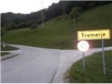
Tremerje is a settlement between Celje and Laško. Coming from the direction of Celje on the way to Laško, before the inn Hochkraut at the crossroads we turn right towards Tremerje. In the opposite direction of the turn at the crossroads there is a bridge over the Savinja, where on the other side of the Savinja there is the central Celje wastewater treatment plant, financed from European funds, which is shown on the notice board. Coming from the direction of Laško at that crossroads we turn left. Immediately after the turn the settlement is marked with the sign "Tremerje". We continue on the main road into the left turn, then straight through the settlement approx 1 km towards the south, until we get to a large parking lot on the left side just by the railway. Near the parking lot on the opposite side of the road there is a sign for the Žerdonerjeva planinska pot to "Veliki Slomnik". Even otherwise, continuing further with a car no longer makes sense, because approx 300 meters ahead the flat part of the road ends; in the past there was the underpass Tremerje, which was several times flooded.
Route description:
From the parking spot, we go on the asphalt road forward towards the south in the direction of Laško approx 300 meters, all the way to the former well-known underpass Tremerje, which years ago "paralysed and frayed nerves" mainly because of frequent floods and too narrow passage. Before the underpass we go around the homestead on its left side, or on the asphalt road we turn right upwards towards the west. At first among lonely homesteads we follow the asphalt road, the blazes and signs for "Šmohor", and further we pass on to a macadam road. At the end of the road among houses we further pass on to a forest path, partly also a cart track, which we follow to the left, then right steeper upwards. We again join the macadam, perhaps also a forest road, and turn sharply left, from the right also joins the path from Liboj, which runs below the "libojska stena" of Veliki Slomnik. We follow the forest road upwards. It rises pleasantly to an abandoned homestead, where we turn through the yard quite sharply right upwards and below another homestead and by a weekend cottage we step onto the plain to a crossroad of paths. In accordance with the signs for "Šmohor" we continue sharply left upwards into the forest. The surface is very pleasant and finally a proper hiking forest path. We follow the path, the marking in this part is excellent, the path is varied in a not too strenuous ascent. Further a short section across meadow/pasture clearing. After a short section through the forest, on the flat part of the path from the right joins another hiking path from Liboj. A few more steps and we come out of the forest onto the road, where a little ahead and downwards we notice directional signs towards Malič. To the right somewhat downwards on the meadow we notice an almost completed large building; if we continued in its direction we would reach Dom na Šmohorju, but we turn left into the forest towards Malič on its western ridge. The path in the eastward direction further runs roughly parallel with the macadam road, which also leads to Malič, but hikers prefer the path through the forest or ridge with some ascents and descents. After some time the path brings us to the take-off point for paragliders. Further the path ascends steeply and along the forested western ridge of Malič quickly brings us to the summit.

Along the route: Dom na Šmohorju (784m)
Photos:
 1
1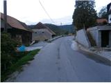 2
2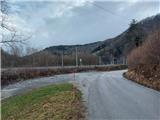 3
3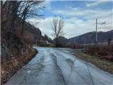 4
4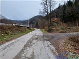 5
5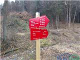 6
6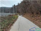 7
7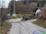 8
8 9
9 10
10 11
11 12
12 13
13 14
14 15
15 16
16 17
17 18
18 19
19 20
20 21
21 22
22 23
23 24
24 25
25 26
26 27
27 28
28 29
29 30
30 31
31 32
32 33
33 34
34 35
35 36
36 37
37 38
38 39
39 40
40 41
41 42
42
Discussion about the trip Tremerje - Malič (on western ridge of Malič)
To post a comment you must log in:
If you do not yet have a username, you must first
register.