Turkov rovt (Vrata) - Požgana Mlinarica
Starting point: Turkov rovt (Vrata) (941 m)
| Latitude/Longitude: | 46,41790°N 13,85800°E |
| |
Walking time: 2 h 45 min
Difficulty: easy pathless terrain
Elevation gain: 927 m
Elevation difference along the route: 927 m
Map: Triglav 1:25.000
Recommended equipment (summer):
Recommended equipment (winter): ice axe, crampons
Views: 13.851
 | 2 people like this post |
Access to starting point:
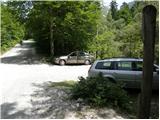
We leave the Gorenjska motorway at the Jesenice - west (Hrušica) exit and continue driving in the direction of Kranjska Gora. A little before Dovje, signs for Mojstrana, Krma, Kot and Vrata direct us to the left onto a somewhat narrower road, along which we quickly arrive in Mojstrana. Through Mojstrana we follow the signs for the alpine valley Vrata, and we follow the mentioned road for good 10.5 km (signs along the road), then on the left side we notice a brook and across it a poor forest road which is closed with a barrier. We park in a suitable place between the road and the brook, of course in such a way that we do not obstruct the passage across the water.
Route description:
From the parking lot, we first cross the river Bistrico; on the other side we continue only a few meters to the right and then turn left uphill onto a footpath. The path then ascends quite steeply through the forest for some time and later brings us out of the forest onto extensive scree fields. We continue along a well-visible trail, which a little further turns right so as to avoid the steep slopes on the left side of the valley. We ascend the scree to the foot of the walls, where the path turns left and then ascends diagonally across the scree.
When we come above the steep slopes on the left side of the valley, we do not continue right along the valley Za Cmirom, but continue straight ahead and cross the valley in a gentle descent towards the steep walls of the ridge of Vrbanove špice. After crossing the valley, we head even more to the left towards the scree (northeast of Spodnja Vrbanova špica), which leads towards the slopes of Požgana Mlinarica. Požgana Mlinarica has been well visible from the path for some time and from here is visible as the first vegetated peak in the ridge (viewed from right to left).
At first we ascend diagonally across a slope strewn with numerous rocks, but when we reach the scree with smaller stones we will also notice a trail leading upwards across the scree. At the end of the scree we continue along the trail, which leads us left through dwarf pines and larch forest. The path is sufficiently well visible further on and we can follow it without major difficulties. In the final section, the path ascends more steeply a few times and brings us to a very panoramic summit.

Photos:
 1
1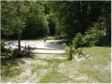 2
2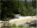 3
3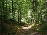 4
4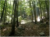 5
5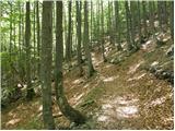 6
6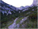 7
7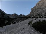 8
8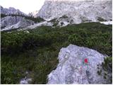 9
9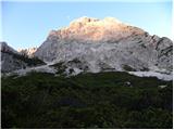 10
10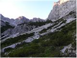 11
11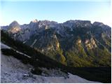 12
12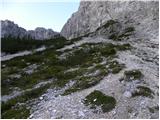 13
13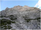 14
14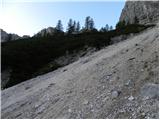 15
15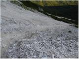 16
16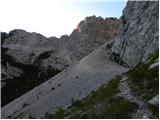 17
17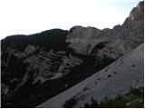 18
18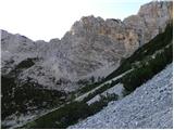 19
19 20
20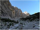 21
21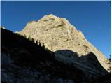 22
22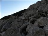 23
23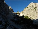 24
24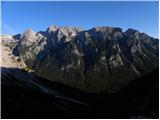 25
25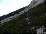 26
26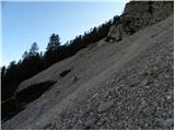 27
27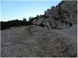 28
28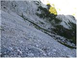 29
29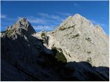 30
30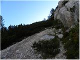 31
31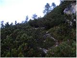 32
32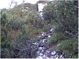 33
33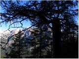 34
34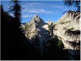 35
35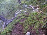 36
36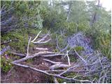 37
37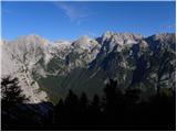 38
38 39
39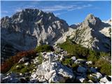 40
40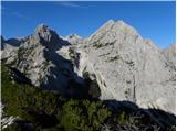 41
41 42
42
Discussion about the trip Turkov rovt (Vrata) - Požgana Mlinarica
|
| Lunca15. 09. 2012 |
Today I went along this path... it's by no means easy... and it's really unmarked... Lots of cairns, some for PP, some really for the summit, total confusion and you can easily get lost. Well, summit found, views phenomenal (leaving aside some cloudiness  ), photo report to follow tomorrow ), photo report to follow tomorrow
|
|
|
|
| ločanka7. 06. 2015 |
This description has an error right at the start. The start is at 10.5 km, not at 11.5.
|
|
|
|
| Tadej8. 06. 2015 |
Thanks for the warning, I have corrected it.
|
|
|
|
| franck14. 12. 2016 |
Yesterday my wife and I were at Požgana Mlinarica. The trail is dry, snow is only a trace. The entire trail to the summit was in shade, but at the top there was plenty of sun. The views were magnificent.
|
|
|
|
| Batistuta23. 08. 2020 |
Yesterday we did a tour from Kosmačeva preval along the entire Mlinaric ridge to Požgana Mlinarica, then descent to Turkov rovt in Vratih.
Total duration 8.5 h. This is possible only with two cars, one left in Kot, the other in Vratih. We three very experienced hikers fully rated the tour as very demanding.
IMPORTANT: if looking for the path to Turkov rovt at Požgana Mlinarica, it branches off to the right at the very summit and is poorly visible. Yesterday we placed a large cairn there, which wasn't there before. We made a mistake by going straight ahead from the summit, where there is initially a very nice path (which can easily mislead you), but after 5 minutes it runs into scrub. There, a very steep path branches off to the left down towards Kot, which leads nowhere, similarly it's possible to go through scrub on a barely visible trail, which also leads nowhere but reaches a small scree slope that ends in impassable scrub. We tried all these options, lost a lot of strength, then went back to the summit where we finally found the right path.
Descent along the trail to Turkov rovt is definitely not easy off-trail but demanding off-trail. Scree slopes are full of rocks and large stones, so running on scree is possible only partially, the trail is followable for a while, then disappears among rocks, some cairns are placed to help.
The scree has several tongues, but we must choose the very last one, after which we reach a forest path that takes us to Vratih in less than half an hour.
Views from the Mlinaric ridge are phenomenal, yesterday cloudless. I recommend the path to experienced hikers with excellent fitness and orientation skills.
Good luck! 
|
|
|
|
| JusAvgustin23. 08. 2020 |
Correction. The path towards Kot definitely leads to Kot. Barely noticeable trail leads across the phenomenal ledge all the way to the marked Jakijeva pot. If you already had such problems descending to Turkov rovt, I advise against descent to Kot.
|
|
|
|
| Batistuta24. 08. 2020 |
JusAvgustin: do you mean the path that branches to Kot before Rušnata Mlinarica and goes to Bišćkov studenec, or the actual path that should go from the top of Požgana Mlinarica towards Kot?
Which path is called Jakijeva pot?
|
|
|
|
| Batistuta24. 08. 2020 |
JusAvgustin, for ordinary hikers: what is PP, LR, AS, PM???
|
|
|
|
| n3jc24. 08. 2020 |
LR = Lengarjev rovt
PM = Požgana Mlinarica
AS = Aljažev stolp
PP = PP 
|
|
|
|
| Marko Torelli11. 07. 2021 20:30:15 |
Today in a five-member group + little dog to Požgana Mlinarica. If you've read the above description and checked the map, you'll definitely reach the top; maybe with some extra detour. Since this was our first ascent, we concluded at the end that this is not an easy pathless route but a more demanding unmarked trail. You'll enjoy lots of nasty scree, conditionally usable scree fields, sharp rocks, untrimmed scrub and other mountaineering delicacies that really raise your pulse. Essential equipment: good boots and poles. Otherwise, a beautiful and solitary peak in the heart of the ridges.
|
|
|
To post a comment you must log in:
If you do not yet have a username, you must first
register.