Unterpirkach - Hochstadel (Dreitörlweg)
Starting point: Unterpirkach (636 m)
| Latitude/Longitude: | 46,75920°N 12,92490°E |
| |
Route name: Dreitörlweg
Walking time: 6 h 50 min
Difficulty: difficult marked way
Elevation gain: 2045 m
Elevation difference along the route: 2130 m
Map: Kompass, Lienzer Dolomiten/Lesachtal 1:50.000
Recommended equipment (summer):
Recommended equipment (winter): ice axe, crampons
Views: 429
 | 1 person like this post |
Access to starting point:
From Ljubljana through the Karawanks Tunnel and then on the highway to Spittal. We continue driving in the direction of Lienz, but drive along the Drava Valley to Oberdrauburg, where we turn left in the direction of Kötschach and Plöckenpass. Immediately after the Drava River and the railway track we turn right (at the intersection we notice numerous signs, among them also for the Hochstadelhaus hut), and then on a somewhat narrower road we reach Unterpirkach. Further we drive past a larger chapel and only a few meters ahead over the bridge across the Pirkner stream. Immediately after the bridge we turn left and park on the parking lot by the alpine trail signposts.
Route description:
From the parking lot we continue along the even gravel road that runs along the right side of the nearby stream. After a few minutes the road forks into two parts. The left one ends after some 10 meters at the stream, we continue on the right one, which gradually begins to ascend more steeply. The marked trail soon leaves the increasingly worse road and continues to the right, where it ascends transversely across occasionally somewhat steeper slopes. Higher up the trail returns to the road, which we follow to its end. The marked footpath continues in the same direction, then after some time turns left, where a climbing path soon joins us. We continue along the well-trodden path, which higher up crosses the road (the road is closed to public traffic), then returns to the forest and takes us past Hilda's smoking bench back to the forest road. We immediately leave the road, the marked trail crosses it higher up a few more times, or also follows it briefly. Higher up the forest thins, offering nice views to the east, where we can clearly see the Drava River and part of the Gailtal Alps. The trail returns to the road higher up, which we follow all the way to the Hochstadelhaus alpine hut.
Some huts organize transport to the alpine pasture.
From the alpine hut we continue slightly to the right (direction Hochstadel) and ascend through a short stretch of forest to the Unholdenalm pasture. Here we walk to the right side of the pasture, where at a few huts we step back onto the road. A short even ascent follows along the increasingly worse road, then we arrive at a marked junction. Slightly to the right the direct path to Hochstadel branches off, we continue left along the path called Dreitörlweg. The path initially ascends gently through sparse larch forest, crossing slopes to the south to the Raineck ridge, where it turns west and loses some elevation in the subsequent traverse. In doing so it crosses a few gullies (two larger ones) and then at the alpine pastures begins to ascend again. The ascent follows the mountain ridge for several hundred meters of elevation gain until it ends at a new junction, where it continues to the right. Here begins the secured climbing path of difficulty A to A/B, which in one hour leads to the summit. In doing so it elegantly chooses the path and crosses the slopes of Schneeklamkopf, 2642 m, before transitioning to the final summit slope of the mountain, at the top of which the path also emerges onto the expansive summit of Hochstadel.
Descent is possible via the easier direct path to the Unholdenalm pasture and then along the described path to the starting point.

Along the route: Hochstadelhaus (1780m), Planina Unholdenalm (1800m), Raineck (1968m)
Photos:
 1
1 2
2 3
3 4
4 5
5 6
6 7
7 8
8 9
9 10
10 11
11 12
12 13
13 14
14 15
15 16
16 17
17 18
18 19
19 20
20 21
21 22
22 23
23 24
24 25
25 26
26 27
27 28
28 29
29 30
30 31
31 32
32 33
33 34
34 35
35 36
36 37
37 38
38 39
39 40
40 41
41 42
42 43
43 44
44 45
45 46
46 47
47 48
48 49
49 50
50 51
51 52
52 53
53 54
54 55
55 56
56 57
57 58
58 59
59 60
60 61
61 62
62 63
63 64
64 65
65 66
66 67
67 68
68 69
69 70
70 71
71 72
72 73
73 74
74 75
75 76
76 77
77 78
78 79
79 80
80 81
81 82
82 83
83 84
84 85
85 86
86 87
87 88
88 89
89 90
90 91
91 92
92 93
93 94
94 95
95 96
96 97
97 98
98 99
99 100
100 101
101 102
102 103
103 104
104 105
105 106
106 107
107 108
108 109
109 110
110 111
111 112
112 113
113 114
114 115
115 116
116 117
117 118
118 119
119 120
120 121
121 122
122 123
123 124
124 125
125 126
126 127
127 128
128 129
129 130
130 131
131 132
132 133
133 134
134 135
135 136
136 137
137 138
138 139
139 140
140 141
141 142
142 143
143 144
144 145
145 146
146 147
147 148
148 149
149 150
150 151
151 152
152 153
153 154
154 155
155 156
156 157
157 158
158 159
159 160
160 161
161 162
162 163
163 164
164 165
165 166
166 167
167 168
168 169
169 170
170 171
171 172
172 173
173 174
174 175
175 176
176 177
177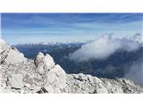 178
178
Discussion about the trip Unterpirkach - Hochstadel (Dreitörlweg)
To post a comment you must log in:
If you do not yet have a username, you must first
register.