Uskovnica (Lom) - Vodnikov dom (via planina Spodnji Tosc)
Starting point: Uskovnica (Lom) (1076 m)
| Latitude/Longitude: | 46,31330°N 13,90540°E |
| |
Route name: via planina Spodnji Tosc
Walking time: 3 h 35 min
Difficulty: difficult marked way
Elevation gain: 741 m
Elevation difference along the route: 915 m
Map: TNP 1:50.000
Recommended equipment (summer): helmet
Recommended equipment (winter): helmet, ice axe, crampons
Views: 3.550
 | 1 person like this post |
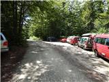
Access to starting point:From the Ljubljana - Jesenice motorway, take the Lesce exit and follow the road towards Bled and further towards Bohinjska Bistrica. Just before Bohinjska Bistrica, at the settlement of Bitnje, continue sharply right towards Pokljuka. After a short ascent, the road levels out and quickly brings us into the Upper Bohinj Valley. At the intersection, continue left (right Pokljuka) and follow the road further to Srednja vas. In the second part of the village, notice the signs for Uskovnica (7 km), which direct us right onto a narrower, initially still asphalted road. Follow the road, which ascends most of the time, to the "Lom" parking lot, where there is a sign prohibiting further driving (further driving permitted only to landowners).
Traffic regime in the Pokljuka and Uskovnica area from 15.6. to 15.10.
Route description:
From the parking lot continue in the direction of Koča na Uskovnici along the road, after which we quickly emerge from the forest, where we notice signs for cheese, milk and homemade products. A few tens of meters further, a short path branches left from the road leading to the nearby sirarna pr Ulčnek, where during grazing season we can buy the aforementioned products; otherwise continue straight to the marked junction a few steps away, where we continue right in the direction of Koča na Uskovnici. The path further leads us first past a landmark (cross), then continues between pastures. When the pastures end on the right side, a marked path from Srednja vas (path "Za Ribnico") joins from the right.
Continue straight, then past weekend houses arrive at a water trough and a few steps further to the place where signs for the already known hut direct us left onto a cart track. A short ascent on the cart track follows and the path takes us to Koča na Uskovnici.
From the hut continue in the direction of Tosca, Draški vrh, Viševnik, Vodnikov dom, Rudno polje and Praprotnica along the path that first crosses the pasture fence, then quickly joins a macadam road which we follow right. The road then leads us between hummocky meadows, then to cross the next fence we quickly arrive at the intersection or junction by the chapel of Mary Queen of Peace on Uskovnica.
After the chapel continue left (straight planina Konjščica, right Rudno polje) along the flat road that leads us across extensive meadows of Uskovnica, then the path brings us to the edge of the forest where it begins to turn into an initially wide cart track. The cart track which further starts to ascend moderately has some junctions, but we follow it in the direction of Vodnikov dom na Velem polju and Triglav. Higher up the cart track which mostly runs through forest turns into a footpath which quickly brings us to a pleasant spring under Mesnova glava called Štapce. At the spring continue straight (right hunters' hut) and continue the ascent on a gentle path that a little further brings us to steep slopes. Soon after reaching the steep slopes, fixed safety gear assists at crossing the steep gully. The path continues along relatively steep slopes that are especially prone to slipping when wet. During the crossing of steep slopes the path several times steeply ascends briefly and then descends again. In the last part of the crossing we cross several very steep gullies over which the path is locally completely eroded (high slip risk). The crossing ends at a larger streambed (usually a spring) after which we enter softer grassy terrain.
A few minutes of easy walking follow and the path brings us to the abandoned planina Spodnji Tosc. The path further begins to ascend moderately and soon brings us to a small junction where we continue sharply right (straight old partly abandoned path) on a well-followable path. The path further starts to ascend ever more steeply and quickly brings us from a belt of sparse forest into dwarf pines where it begins to turn increasingly left. The path soon levels out and brings us from the dwarf pines onto grassy slopes across which in a few minutes of further walking we ascend to the Pokljuka - Triglav path where we turn left.
The path further crosses the southern slopes of Tosca, then in a slight descent crosses a short belt of sparse forest after which we arrive at steep slopes of Tosca. A little further the path along an artificially made wide ledge in slight descent crosses sheer slopes of the same mountain. As the path is quite wide it presents no difficulties (caution due to falling rocks, rockfall in 2008). The path then rises gently again bringing us to a junction where we continue right in the direction of Vodnikov dom (sharply left Voje and Stara Fužina, slightly left Velo polje). Another approx. ten minutes walking without major ascents or descents brings us to Vodnikov dom na Velem polju.
Starting point - Koča na Uskovnici 0:15, Koča na Uskovnici - chapel on Uskovnica 0:05, chapel on Uskovnica - Štapce 0:50, Štapce - Planina Spodnji Tosc 1:15, Planina Spodnji Tosc - Planina Zgornji Tosc 0:30, Planina Zgornji Tosc - Na Zagonu 0:20, Na Zagonu - Vodnikov dom 0:20.

Along the route: Koča na Uskovnici (1154m), Kapela Kraljice miru na Uskovnici (1177m), Izvir Štapce (1452m), Planina Spodnji Tosc (1663m), Planina Zgornji Tosc (1849m), Na Zagonu (1819m)
The trip can be extended to the following destinations: Cesar,
Koča na Doliču,
Vernar,
Dom Valentina Staniča,
Vrh Snežne konte (1 h 40 min),
Šmarjetna glava,
Dom Planika,
Visoka Vrbanova špica,
Begunjski vrh,
Triglavski dom na Kredarici,
Rjavina,
Triglav (2 h 45 min)
Photos:
 1
1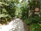 2
2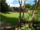 3
3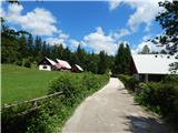 4
4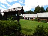 5
5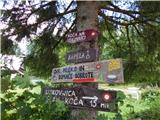 6
6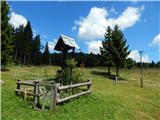 7
7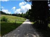 8
8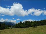 9
9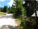 10
10 11
11 12
12 13
13 14
14 15
15 16
16 17
17 18
18 19
19 20
20 21
21 22
22 23
23 24
24 25
25 26
26 27
27 28
28 29
29 30
30 31
31 32
32 33
33 34
34 35
35 36
36 37
37 38
38 39
39 40
40 41
41 42
42 43
43 44
44 45
45 46
46 47
47 48
48 49
49 50
50 51
51 52
52 53
53 54
54 55
55 56
56 57
57 58
58 59
59 60
60 61
61 62
62 63
63 64
64 65
65 66
66 67
67 68
68 69
69 70
70 71
71 72
72 73
73 74
74 75
75
Discussion about the trip Uskovnica (Lom) - Vodnikov dom (via planina Spodnji Tosc)
|
| velkavrh7. 10. 2015 |
The abandoned Planina Spodnji Tosc is well visible from Studorski preval. Today only ruins of the long-abandoned pasture are visible. The same fate befell Planina Zgornji Tosc - also visible ruins of shepherd structures from the path that leads further towards Vodnikov dom.
|
|
|
|
| keti116. 09. 2019 |
I'm wondering if the path from Uskovnica towards Vodnikov dom under Spodnji Tosc has been repaired or if it's still damaged and dangerous for slipping?
|
|
|
|
| garmont16. 09. 2019 |
It has been repaired.
But I saw on the PZS website that due to renewed damage to the path, hiking with children and larger groups of hikers is discouraged.
|
|
|
|
| keti117. 09. 2019 |
Thanks for the answer. Then we'll go somewhere else.
|
|
|
|
| grega_p12. 09. 2021 19:38:47 |
I found an announcement on the net (https://www.pzs.si/novice.php?pid=13584), that the path is OPEN again.
I walked it to Vodnikov dom. The most problematic section (landslide) has reinforced steps in the sand and it seems to me that PD Srednja vas did a good job.
The only thing that bothered me was that they still left signs saying the path is temporarily closed. Not at the bottom at Uskovnica, but only on that mentioned 5min section, about 1h into the hike. Is there a purpose or were they just not removed? I hope it doesn't deter anyone from continuing the path, as it is normally passable, of course with a certain degree of caution.
|
|
|
To post a comment you must log in:
If you do not yet have a username, you must first
register.