Uskovnica (Razpotje) - Koča na Uskovnici
Starting point: Uskovnica (Razpotje) (1215 m)
| Latitude/Longitude: | 46,32670°N 13,91070°E |
| |
Walking time: 20 min
Difficulty: easy marked way
Elevation gain: -61 m
Elevation difference along the route: 5 m
Map: Triglav 1:25.000
Recommended equipment (summer):
Recommended equipment (winter):
Views: 18.966
 | 2 people like this post |
Access to starting point:a) Leave the Gorenjska motorway at the Lesce exit, then follow the signs for Bled and Pokljuka. Continue through Gorje and past the Zatrnik ski slope to Rudno polje on Pokljuka, where there is a large paid parking lot, and nearby a military barracks and shooting range. From here continue straight on the gravel road, which shortly brings us to a junction, where we continue left towards Uskovnica (right Planina Konjščica). From here drive another good 500 m to the former parking lot above Uskovnica. This area is called Razpotje.
Parking is now prohibited at the mentioned parking lot, so we must park already at Rudno polje, which extends the route by about 35 minutes, or choose the starting point Uskovnica (Lom).
b) From Železniki or Podbrda drive to Bohinjska Bistrica, then continue driving towards Bled. Shortly after the Petrol petrol station, located just beyond Bohinjska Bistrica, continue left towards Pokljuka and Jereka. The road first climbs steeply, then gradually flattens after Koriti and brings us to a junction at the bus stop, where we continue right towards Pokljuka, Koprivnik and Jereka (straight Srednja vas). Immediately after the junction we arrive in Jereka, and from the junction in front of the church we continue straight towards Pokljuka (left Podjelje). After Jereka the road begins to climb more steeply again, higher up it flattens and continues along the Mrzli potok. When we join the road from Bled, go left and drive to Rudno polje, where there is a large paid parking lot, and nearby a military barracks and shooting range. From here continue straight on the gravel road, which shortly brings us to a junction, where we continue left towards Uskovnica (right Planina Konjščica). From here drive another good 500 m to the former parking lot above Uskovnica. This area is called Razpotje.
Parking is now prohibited at the mentioned parking lot, so we must park already at Rudno polje, which extends the route by about 35 minutes, or choose the starting point Uskovnica (Lom).
Traffic regime in the Pokljuka and Uskovnica area from 15.6. to 15.10.
Route description:
From the former parking lot at the junction, continue along the gravel road closed to public traffic towards Uskovnica. The road immediately descends quite steeply and quickly brings us to the bridge over Ribnica (Ribnica is the stream separating Uskovnica from Pokljuka). After the bridge, the road turns sharply left, then in a slight descent crosses the slopes above the right bank of Ribnica. A few tens of metres further, a road branches off to the right towards Planina Konjščica, we continue straight to the next junction, located in the immediate vicinity of the Chapel of Mary Queen of Peace. Here another path continues right towards Planina Konjščica, straight along the right side of the chapel the path continues towards Vodnikov dom na Velem polju and Triglav, we continue left towards Koča na Uskovnici. Continue along the road, which soon crosses a fence, then near a hummocky meadow continue left again towards Koča na Uskovnici. From the last junction to the hut it is only about 50 m walk.
Starting point - Chapel 0:15, Chapel - Hut 0:05.

Along the route: Kapela Kraljice miru na Uskovnici (1177m)
The trip can be extended to the following destinations: Planina Zajamniki,
Planina Konjščica (1 h 5 min),
Planina pod Mišelj vrhom (4 h),
Velo polje (3 h 30 min),
Vodnikov dom (3 h 15 min),
Ablanca,
Jezerski Stog (5 h 15 min),
Viševnik,
Mali Draški vrh (3 h 10 min),
Vernar (4 h 30 min),
Veliki Draški vrh,
Tosc (4 h),
Dom Valentina Staniča (6 h 15 min),
Dom Planika (4 h 45 min),
Triglavski dom na Kredarici (5 h 15 min),
Triglav (6 h)
Photos:
 1
1 2
2 3
3 4
4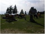 5
5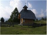 6
6 7
7 8
8 9
9 10
10 11
11 12
12 13
13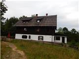 14
14 15
15
Discussion about the trip Uskovnica (Razpotje) - Koča na Uskovnici
|
| prlekj14. 01. 2009 |
I'm interested in what the path from Srednja vas to the hut at Uskovnica is like! Namely, with friends we are planning a three-day hike across Triglav in spring! What are the connections to get back to the car?
|
|
|
|
| Klin15. 01. 2009 |
I suggest the following route: Srednja vas, Uskovnica, Vodnikov dom, Planika (overnight), Triglav, Dolič, Prehodavci, Triglavska jezera (overnight), Ovcarija, Dedno polje, Blato, Voje, Stara Fužina, Srenja vas.
And don't forget that in spring the paths around Triglav are still snowy.
|
|
|
|
| triglavski15. 01. 2009 |
Planika will also be closed in spring, so sleeping won't be possible, but you could bivouac at the Triglav Lakes.
|
|
|
To post a comment you must log in:
If you do not yet have a username, you must first
register.