V Koncu - Dolgi hrbet (via Kokrsko sedlo)
Starting point: V Koncu (900 m)
| Latitude/Longitude: | 46,34200°N 14,56820°E |
| |
Route name: via Kokrsko sedlo
Walking time: 5 h
Difficulty: very difficult marked way
Elevation gain: 1573 m
Elevation difference along the route: 1700 m
Map: Kamniške in Savinjske Alpe 1:50.000
Recommended equipment (summer): helmet, self belay set
Recommended equipment (winter): helmet, self belay set, ice axe, crampons
Views: 29.267
 | 3 people like this post |
Access to starting point:
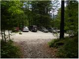
We drive to Kamnik and follow the road further towards the valley of Kamniška Bistrica. From the house in Kamniška Bistrica we continue driving on the forest road, which brings us higher up to a junction, where we continue straight (right Jermanca, starting point for Kamniško sedlo). The road then brings us past Žagana peč to the parking lot at the lower station of the cargo cableway to Kokrsko sedlo.
Driving from the hut in Kamniška Bistrica to the parking lot V Koncu is now forbidden (traffic sign), this extends the path by less than an hour.
Route description:
From the parking lot at the cargo cableway we head onto the footpath in the direction of Kokrsko sedlo and Grintovec. The path, which runs through the forest, ascends gently at first, but this section of the path is short. Already after a few minutes of walking, however, the path starts to ascend steeply and a little higher fixed safety gear helps us, which comes in handy on wet and slippery ground (dry: undemanding). The well-visible and still steep path then starts turning somewhat to the right higher up. The steepness eases for a short time and the path takes us out of the forest onto avalanche slopes below Kokrsko sedlo. Here the path stands vertical again and ascends at the foot of the walls of Kalška gora and Mali vrh amid ever more beautiful views (the most beautiful are on the peaks above the valley of Kamniška Bistrica). Easy to follow but due to a lot of stones (slightly overgrown scree) on the path, this strenuous path brings us after a good 2 hours of walking to Kokrsko sedlo, where Cojzova koča stands.
From the saddle we continue right in the direction of Grintovec, Kočna and Skuta. The path steeply ascends right above the saddle and takes us a little higher to a junction, where the path to the bivouac pod Grintovcem and Skuta branches off to the right (straight to Grintovec via Streha and Kočna). We head onto this initially somewhat less visible pathlet, which takes us in moderate ascent to the picturesque passage over Mala vratca. Beyond the narrow passage of Mala vratca, the path starts descending on a steep and occasionally somewhat exposed slope. At the end of the descent, which takes us about 100 meters of elevation, a few pitons assist us. This is followed by crossing the gully and then ascent through high-mountain terrain to the bivouac pod Grintovcem.
From the bivouac we continue on the marked path, which quickly takes us to a junction. We continue straight in the direction of Skuta and Grintovec (right Kamniško sedlo, Rinke and Turska gora) on a relatively gentle path, which soon takes us to the next junction. Again we continue on the left path (right Skuta), which takes us further across karst terrain full of limestone pavements and sinkholes. Further on we carefully follow the blazes, which after a short ascent take us to Mlinarsko sedlo, where the path from Jezersko joins. Here at the junction we head right in the direction of Dolgi hrbet and Skuta (left Grintovec). From here to the summit of Dolgi hrbet we have only a good 30 minutes of secured climbing path. Initially the path leads across the southern slopes of Dolgi hrbet, but with the aid of numerous fixed safety gear it quickly takes us back onto the ridge. Further we walk along the ridge, in places the path leads above 1000 m precipices. This path, which is dangerous for slipping when wet, soon takes us to the summit of Dolgi hrbet.
V Koncu - Cojzova koča 2:15, Cojzova koča - bivak pod Grintovcem 1:15, bivak pod Grintovcem - Dolgi hrbet 1:30.

The trip can be extended to the following destinations: Štruca,
Skuta
Photos:
 1
1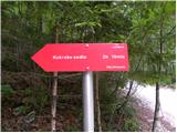 2
2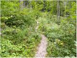 3
3 4
4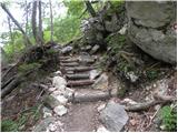 5
5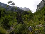 6
6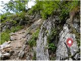 7
7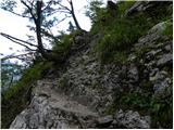 8
8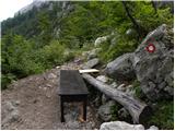 9
9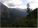 10
10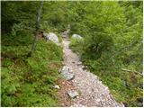 11
11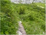 12
12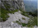 13
13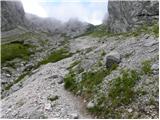 14
14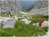 15
15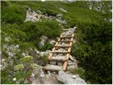 16
16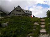 17
17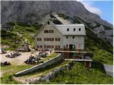 18
18 19
19 20
20 21
21 22
22 23
23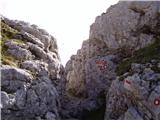 24
24 25
25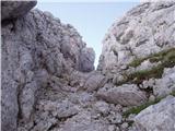 26
26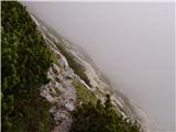 27
27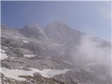 28
28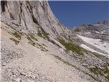 29
29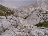 30
30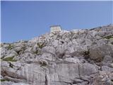 31
31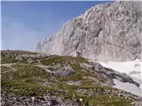 32
32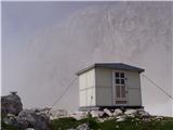 33
33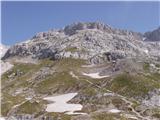 34
34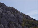 35
35 36
36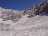 37
37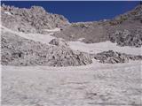 38
38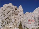 39
39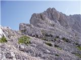 40
40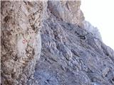 41
41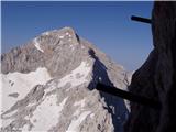 42
42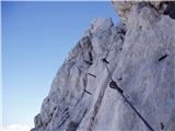 43
43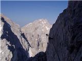 44
44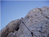 45
45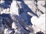 46
46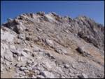 47
47 48
48
Discussion about the trip V Koncu - Dolgi hrbet (via Kokrsko sedlo)
|
| pohodnik3810. 08. 2012 |
Last Sunday hiked Dolgi hrbet but in the opposite direction from Skuta to Mlinarsko sedlo, very demanding, the trail is without special features but protections in good condition
SOME PICTURES FROM DOLGI HRBET
|
|
|
|
| nincokl3. 07. 2013 |
Does anyone know what the conditions are like on this trail to Dolgi hrbet, I would go on Saturday.....thanks for info..
|
|
|
|
| lenart3. 07. 2013 |
Today I went from Mlinarsko sedlo over Dolgi hrbet to Skuta. Conditions okay, the only problem is the path from Skuta to the bivouac, where there is a fairly steep snowfield... without winter gear I don't think it's wise. Others also turned back here.
|
|
|
|
| kwhtre4. 07. 2013 |
@lenart: you wrote that the path from Skuta to the bivouac is problematic due to snowfield. Did you mean bivouac under Skuta or under Grintovec?
That's why I'm asking, as I planned this weekend from Cojzova koča over mala vratca to bivouac under Grintovec and then to Skuta, wondering if I still need ice axe and crampons.
|
|
|
|
| _sandra_4. 07. 2013 |
if going from Skuta towards bivouac under Grintovec there's still snow, surely lenart meant that too..
|
|
|
|
| kwhtre5. 07. 2013 |
OK, thanks for the info...
|
|
|
|
| navdušena2. 08. 2015 |
What if we go directly from Skuta to Dolgi hrbet? Does anyone have photos from this trail - what does it look like?
|
|
|
|
| smatjaz2. 08. 2015 |
Which trail did you plan to take up and which down?
|
|
|
To post a comment you must log in:
If you do not yet have a username, you must first
register.