V Koncu - Skuta (via Kokrsko sedlo)
Starting point: V Koncu (900 m)
| Latitude/Longitude: | 46,34200°N 14,56820°E |
| |
Route name: via Kokrsko sedlo
Walking time: 5 h 30 min
Difficulty: difficult marked way
Elevation gain: 1632 m
Elevation difference along the route: 1800 m
Map: Kamniške in Savinjske Alpe 1:50.000
Recommended equipment (summer): helmet
Recommended equipment (winter): helmet, ice axe, crampons
Views: 174.958
 | 7 people like this post |
Access to starting point:
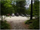
We drive to Kamnik and follow the road ahead towards the valley of Kamniška Bistrica. From the hut in Kamniška Bistrica we continue driving on the forest road which brings us higher to a crossroad, where we continue straight (right Jermanca, starting point for Kamniško sedlo). The road then past Žagana peč brings us to the parking lot at the lower station of the cargo cableway to Kokrsko sedlo.
Driving from the Koča in Kamniška Bistrica to the parking lot V Koncu is now forbidden (traffic sign), this extends the path by less than an hour.
Route description:
From the parking lot at the cargo cableway we head onto the footpath in the direction of Kokrsko sedlo and Grintovec. The path, which runs through the forest, initially ascends only gently, but this section of the path is short. Already after a few minutes of walking the path starts to ascend steeply and a little higher there are fixed safety aids, which come in handy on wet and slippery ground (in dry conditions undemanding). The well-visible and still steep path higher starts to turn slightly to the right. The steepness then eases for a short time and the path brings us out of the forest onto avalanche slopes below Kokrsko sedlo. Here the path becomes steep again and with ever more beautiful views (these are the most beautiful on the peaks above the valley of Kamniška Bistrica) ascends at the foot of the walls of Kalška gora and Mali vrh. Easily followable but due to a lot of stones (slightly overgrown scree) on the path strenuous, after good 2 hours of walking it brings us to Kokrsko sedlo, where Cojzova koča stands.
From the saddle we continue right in the direction of Grintovec, Kočna and Skuta. The path immediately above the saddle ascends steeply and a little higher brings us to a junction, where to the right branches the path to the bivouac under Grintovec and Skuta (straight Grintovec via Streha and Kočna). We take this initially somewhat less visible track, which in moderate ascent brings us to the picturesque passage over Mala vratca. Behind the narrow passage of Mali vratca the path starts descending on a steep and occasionally somewhat exposed slope. At the end of the descent, which takes us about 100 elevation meters, some pegs assist us. This is followed by crossing the gully and then ascent through high-mountain terrain to the bivouac under Grintovec.
From the bivouac we continue on the marked path, which quickly brings us to a junction. We continue straight in the direction of Skuta and Grintovec (right Kamniško sedlo, Rinke and Turska gora) on a relatively gentle path, which soon brings us to the next junction. We continue right in the direction of Skuta (straight Mlinarsko sedlo) on the path which through the karst terrain of Veliki podi brings us to the foot of a moderately steep wall. Here the path becomes vertical and with the help of natural holds we overcome the short wall between Dolgi hrbet and Štruca (in wet great risk of slipping). At the top of the ascent the path from Dolgega hrbeta joins from the left. We continue right, where then in a slight descent with the help of some pegs on the left side we bypass the summit of Štruca. The path then brings us to an indistinct saddle between Štruca and Skuta, from which in 15 minutes via the undemanding summit slope of Skuta we ascend to the summit.
V Koncu - Cojzova koča 2:15, Cojzova koča - bivak pod Grintovcem 1:15, bivak pod Grintovcem - Skuta 2:00.

Photos:
 1
1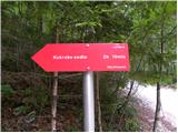 2
2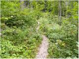 3
3 4
4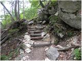 5
5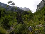 6
6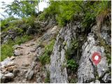 7
7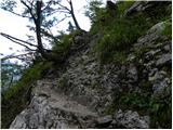 8
8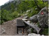 9
9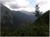 10
10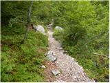 11
11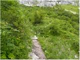 12
12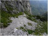 13
13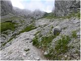 14
14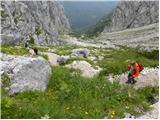 15
15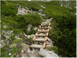 16
16 17
17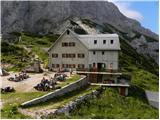 18
18 19
19 20
20 21
21 22
22 23
23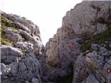 24
24 25
25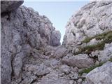 26
26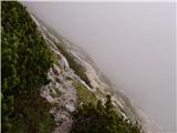 27
27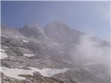 28
28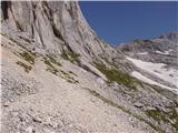 29
29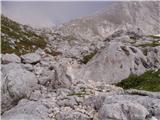 30
30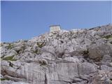 31
31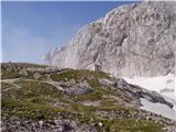 32
32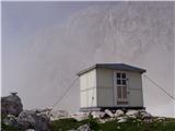 33
33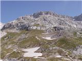 34
34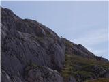 35
35 36
36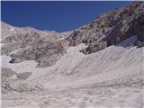 37
37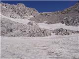 38
38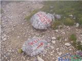 39
39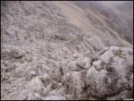 40
40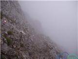 41
41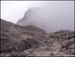 42
42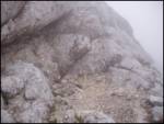 43
43 44
44
Discussion about the trip V Koncu - Skuta (via Kokrsko sedlo)
Show older messages
|
| andrej7674. 08. 2007 |
" We have to climb the easier wall between Dolgi hrbet and Štruca all the way to the ridge. Without protections-Caution " . This deters me a bit from going up as I'm not much of a climber. So no protections or pegs on this most demanding part? 
|
|
|
|
| Gost4. 08. 2007 |
The path is quite steep there, but no climbing skills are required.
|
|
|
|
| andrej7675. 08. 2007 |
Yes thanks, then I'll take Štruca along so I'm not hungry.  
|
|
|
|
| majdicst4. 09. 2007 |
On September 1st we returned from Skuta to the valley along this path. Interesting path that also requires some technical knowledge, especially before descending from below Dolgi hrbet to the scree and the final ascent to Vratca. But it's true that the eastern approach to Skuta is considerably more difficult. Everything was great except the last part of the path, as rain caught us just above the tree line on the descent to the valley and thoroughly soaked the path. In such conditions, quite a bit of caution is needed so you don't slip on wet roots or rocks. I wouldn't recommend it to complete beginners.
|
|
|
|
| Gost11. 10. 2007 |
The hike is nice - personally, the nicest path to Skuta for me is through Žmavcarje past the bivouac under Skuta to the summit. It's not too demanding for the upper part, even though it's secured mostly only with pegs. This path is better for descent
|
|
|
|
| joža x8. 06. 2008 |
does anyone know the conditions on the path Kokrsko sedlo-Skuta, I mean especially snow and ice?
|
|
|
|
| Nickster22. 07. 2008 |
There's still some snow as I saw from Jezersko.
I'd rather go in August
lp
|
|
|
|
| vertov28. 08. 2009 |
Did the tour today and I have to say it's one of the best routed paths in the Kamnik Alps. Marking is also top-notch.
I was completely alone from Kokrsko sedlo all the way to the top of Skuta. Really crazy feeling when you have the whole mountain to yourself...
|
|
|
|
| markoz5. 07. 2010 |
In the near future I plan to go to Skuta, preferably on Sunday 11.7.10. For safety reasons alone, I'm interested if anyone has similar interests?
|
|
|
|
| jozo18. 07. 2010 |
markoz, have you already been to Skuta, I'm also heading up there on Tuesday, of course depending on the weather.
|
|
|
|
| rakec18. 07. 2010 |
jozo, I'm going on Saturday or Friday. If you don't make it on Tuesday, we can go together.
|
|
|
|
| jozo18. 07. 2010 |
Since I spend most weekends at work, Tuesday is the only possible day next week, so unfortunately. But if you manage to reschedule your visit to Skuta for Tuesday, let me know on ZS, and we'll arrange it.
|
|
|
|
| svenson18. 10. 2011 |
Conquered the described path today-first time. Despite the exceptionally nice weather I met only a handful of hikers who like me probably caught the last chance this year for a hike in summer gear.
|
|
|
|
| Marky13. 11. 2011 |
This weekend I conquered the summit.. At times it was very strenuous, especially on the descent, as I strained my knee so I needed more time for the descent than for the ascent.. but, the summit is conquered, and I also made it back to the valley.
The path itself is great and not extra demanding. Given the date, "winter gear" is needed to reach the summit.. hehe.. crampons, ice axe as you wish You only need the gear for the last approx. 150m of elevation.
You can see pictures from my ascent at M-foto.si
|
|
|
|
| katty13. 11. 2011 |
@Marky, wonderful pictures. Congratulations on the great ascent.
|
|
|
|
| ljubitelj gora13. 11. 2011 |
Picture 13/14: During descent a 1-2kg rock flew out of the wall, just a few seconds faster and it wouldn't have ended well... straight onto the marked path After observing, I saw a large broken rock on the edge in the middle of the wall, so caution under that wall.
|
|
|
|
| pohodnik3813. 11. 2011 |
Under Dolgi hrbet be especially careful, stones often fly down there, it happened to me in July but chamois triggered them
|
|
|
|
| ljubitelj gora14. 11. 2011 |
@pohodnik38
A 24-year-old hiker had an accident there, somewhere on the scree.
|
|
|
|
| kary1. 05. 2012 |
And does anyone know what the snow conditions are like?
|
|
|
|
| Mihy28. 05. 2012 |
Today unsuccessful attempt to conquer Skuta. In steep ascent before the wall we gave up due to too much snow and slip hazard. Absolutely need crampons and ice axe, we were without anything 
Otherwise wonderful path. Repeat ascent in July or August
|
|
|
|
| _sandra_26. 06. 2012 |
Has anyone been recently to Skuta via this path? Is there still any snow?
|
|
|
|
| _sandra_2. 07. 2012 |
we went via the long ridge to Skuta, no snow anywhere at all, so it was great 
|
|
|
|
| Janiel745. 07. 2012 |
Sorry for the question. Can you park here? And how is the road to the parking? I probably mixed it up a bit with Jermanca or something?
|
|
|
|
| tol5. 07. 2012 |
According to the rules you can't park. The sign prohibits driving from the start of the path to Kamniško sedlo.
Yes, people also drive to Jermanca and to the lower station at Kokrško sedlo.
The road is getting more and more destroyed, at some parts it becomes impassable until someone breaks the potholes that formed.
|
|
|
|
| Janiel745. 07. 2012 |
Thanks. Well then this is off.
|
|
|
|
| Janiel745. 07. 2012 |
The option from Suhadolnik remains.
|
|
|
|
| _sandra_6. 07. 2012 |
@Janiel74: if you want to go to Cojzova koča you can park at Žagani peči or even higher, at the cargo cableway, the no traffic sign is already down at Dom v Kamniški Bistrici, but personally I've never gotten a ticket for wrong parking..road to the lower station of the cargo cableway is newly filled, so no big potholes..
|
|
|
|
| Janiel746. 07. 2012 |
Aha Somehow I'd like to go on a path I haven't gone through yet. Is this the parking as on pic 1.?
|
|
|
|
| mojca.sedej21. 08. 2012 |
From Cojzova koča to Skuta and then to Kamniško sedlo: what special features are there on the path?
|
|
|
|
| AnzeKozjek16. 09. 2013 |
I'm asking because of my girlfriend, is the path very exposed (crossing above deep precipices)? or is it just somewhat technical climbing, but not so vertiginous...?
Thanks for the answer!
|
|
|
|
| smatjaz17. 09. 2013 |
AnzeKozjek, if you decided to go to Skuta via Kokrsko sedlo, the only thing is right above Kokrško sedlo through Mala vratca under the long walls there is a short section of the path secured with cables and exposed. If she is slightly dizzy, put on a via ferrata set with lanyards and there shouldn't be any problems. Helmet is mandatory. Later there is only the section from the scree between Štruca and Dolgi hrbet unsecured ascent, but it's not vertical. Both sections don't seem technically demanding to me, as I crossed them with a thirteen-year-old. Of course that's for us. For you, you'll see right from Mala vratca if it will go, you can still turn back as you won't be too far from Cojzova koča yet. Cheers and safe steps to you. PS: before Saturday it won't be pleasant up there due to the weather.
|
|
|
|
| otiv17. 09. 2013 |
The path as a whole is not demanding, at three places it is slightly exposed, which can be seen in photos 27, where the path goes under the Dolge stene of Grintovec, photo 41, where the path ascends steeply, and photo 43, where the path goes behind Štruca.
Good luck!
|
|
|
|
| Binchy5. 08. 2014 |
Hi! Has anyone gone on this trail recently? How are the snow patches? Are they still there? Is it dangerous?
Thanks!
|
|
|
|
| juhejnaprej5. 08. 2014 |
Binchy: On Sunday during descent from Skuta I partially walked this trail, making a detour via dolgi hrbet-mlinarsko sedlo-kemprlov bivak. The only possible snow patches are under the saddle between štruco and dolgi hrbet and on velikih podih, so on still fairly flat terrain and the trail is normally passable (ice axe/crampons no longer needed).
I also met approx. 5 hikers who took this trail and all confirmed no major issues on the trail.
|
|
|
|
| Binchy5. 08. 2014 |
juhejnaprej thanks for the information! We plan to do a circular trail back to Kokrsko sedlo - sleeping in bivouac under Skuta then over Sleme to bivouac under Grintavcem and from there back to Kokrsko sedlo. How is this trail?
|
|
|
|
| juhejnaprej6. 08. 2014 |
No problem. I don't know much about the snow conditions on the ridge path, because I haven't been there yet this year, but I assume it's similar to Velikih Podih. The path is otherwise very nice with a couple of demanding but well-protected sections that don't reach the difficulty of the descent from Skuta to the bivouac below Skuta, which will be the most demanding part of your route. Right at the entrance to the Skuta wall there is also a small snowfield, which can be crossed with a bit of care even without an ice axe.
That's why I would perhaps rather climb Skuta from malih podov, and descend towards Velikih Podih via Štruca, but your variant is also fine.
|
|
|
|
| bo_zl29. 08. 2014 |
Today I did this wonderful tour accompanied by a lady from Novo mesto. Thanks again for the company....
|
|
|
|
| TineR21. 06. 2016 |
Hello, interested in conditions on Skuta (snow)? Is winter gear still needed? Plan to bivouac in the bivouac under Skuta, then next day go over Štruca to Grintovec and descend to the valley.
|
|
|
|
| tomislavo3. 07. 2016 |
Hi, has anyone hiked the path Kokrško sedlo - Dolgi hrbet - Štruca - Skuta in the last week, how much snow is left and where.
thanks
|
|
|
|
| redbull3. 07. 2016 |
Only the podi still have snow, which is not difficult.
Good luck
|
|
|
|
| tomislavo3. 07. 2016 |
Thanks for the information.
|
|
|
|
| planika823. 07. 2016 |
And how is it with the snow under Skuta towards the Rinke?
Thanks.
|
|
|
|
| planika824. 07. 2016 |
I meant the descent from Skuta towards Mali podi and then further to the ascent to Rinke.
|
|
|
|
| katjah2. 08. 2016 |
Hi! Is it possible to visit the bivouac under Skuta also via this path?
Best, Katja
|
|
|
|
| Gost2. 08. 2016 |
Yes. But it'll be quite long. From the top of Skuta you descend in the direction of Turska gora, from the marked path you turn towards the bivouac (marked with a cairn, no marks) then via Žmavčarje to the starting point. I find the path easier in the opposite direction.
|
|
|
|
| rasto_r28. 08. 2017 |
No driving ban sign is visible in Kamniška Bistrica. Anyway, you couldn't even park there due to the crowd. Over the weekend everything was parked from Žagana peč to the cable car.
|
|
|
|
| rokopoko22. 10. 2019 |
I'd like to go to Skuta via this trail but wondering if anyone has gone with a dog? Especially those few pegs at the end worry me...
|
|
|
|
| anak22. 10. 2019 |
Our Abby (border collie) managed the trail without trouble. She's used to hills though.
|
|
|
|
| Branee23. 10. 2019 |
Border is one of the most agile and intelligent breeds, especially in agility, few dog breeds match it.
|
|
|
|
| rokopoko23. 10. 2019 |
thanks anak.. we have a mixed breed though, but it's similarly agile as border collie.. if fear grips it I won't carry it over those pegs anyway.. lp
|
|
|
|
| hijacker25. 10. 2019 |
how are the conditions on the long ridge Struca Skuta?
is it still possible without winter gear?
best regards
|
|
|
|
| rokopoko25. 10. 2019 |
Well today our Cookie managed it... no need to carry him at all.. at the end he was pretty exhausted, just like me... otherwise no snow, as it's the sunny side and the sun is really scorching these days...
|
|
|
|
| Kinki4. 07. 2023 20:27:45 |
Hello. I'm interested if there's still any snow from Kokrsko sedlo towards Skuta or if it's possible to cross the snowfields without winter gear?
|
|
|
|
| Climber914. 07. 2023 22:01:37 |
I was there on Friday. Over Žmavčarje a couple of snowfields, quite uncomfortable to cross, especially towards the saddle. I would recommend gear.
|
|
|
|
| smatjaz5. 07. 2023 18:47:19 |
On Sunday I looked from Grintovec... the path kokrško sedlo - bivak pod Grintovcem - Mlinarsko sedlo is snowy in places (winter gear). Due to clouds the view towards Skuta was poor, but as far as could be seen the entry from Velikih podov into the wall between Štruco and Dolgim hrbtom is under snow too, so yes, I think you need gear. South of Skuta all full of snowfields, north even worse. True that snowfields are steadily disappearing, but at this moment it's still more winter-like.
|
|
|
|
| goretz5. 09. 2023 21:00:31 |
Hello,
I'm interested if the road to the starting point and the hiking trail itself are passable/drivable considering the recent floods.
Best regards
|
|
|
|
| Ficla25. 09. 2023 09:47:59 |
The road to the starting point is passable.
|
|
|
|
| JureZT25. 09. 2023 15:53:29 |
@Ficla, so you can get there with a normal car then?
|
|
|
|
| Nerad26. 09. 2023 09:01:34 |
@JureZT, yes with any car
|
|
|
|
| Ficla26. 09. 2023 09:54:02 |
Yes.
|
|
|
|
| Tajka671. 10. 2023 09:20:17 |
Yesterday on this path to Skuta and then to Štruca. Cloudy, just right for walking, it cleared up at the top. In the bivouac under Grintavec, Czechs have been bivouacking since 16h. Good path with great company
|
|
|
|
| iza_2. 07. 2025 19:10:39 |
Hi, has anyone been on this path to Skuta this year yet?
Is the path in good condition or is there any snow?
Thanks for the info!
|
|
|
|
| mylix17. 07. 2025 14:50:23 |
I checked at the hut and they told me that the path is dry.
|
|
|
|
| Majamuhovec1. 09. 2025 10:55:22 |
Hi. How is the road to V Koncu? Has anyone driven there in the last few days by chance? Thanks
|
|
|
|
| Nehodimvhribe3. 09. 2025 08:55:27 |
The road is quite good, but not asphalt, so second gear and off we go.
|
|
|
To post a comment you must log in:
If you do not yet have a username, you must first
register.