Žabnice / Camporosso in Valcanale - Svete Višarje / Monte Lussari
Starting point: Žabnice / Camporosso in Valcanale (858 m)
| Latitude/Longitude: | 46,50440°N 13,54040°E |
| |
Walking time: 2 h 30 min
Difficulty: easy marked way
Elevation gain: 908 m
Elevation difference along the route: 910 m
Map: Julijske Alpe - zahodni del 1:50.000
Recommended equipment (summer):
Recommended equipment (winter):
Views: 138.498
 | 2 people like this post |
Access to starting point:
Via the border crossing Rateče or the border crossing Predel we drive to Trbiž / Tarvisio, then we continue driving in the direction of Vidma / Udine and the settlement Žabnice / Camporosso in Valcanale. When Trbiž ends, just a little after the Eurospar store (the store is located on the right side of the road), still before the main roundabout, we turn left onto Via Lussari street. We drive a few 100 meters along the mentioned street, then we arrive at a smaller intersection, from the intersection we continue straight and after the intersection we park on the parking lot on the right side of the road. We park on the lower part of the parking lot, on the upper part parking is prohibited by a traffic sign.
Route description:
From the starting point, we continue on the asphalt road closed to public traffic, which leads us past a few more houses. Above the hamlet, the path leads past an information board, then the asphalt ends. We continue on a macadam road which leads us through Višarski graben, through which the stream Rio Lussari flows. Higher up, the road changes into a wide cart track, and beside it the Stations of the Cross appear.
We continue ascending for some time on the cart track, from which we occasionally get some views in the direction of the Carnic Alps, where we can clearly see Ojstrnik. Higher up, from the cart track we turn right onto the marked footpath in the direction of Kamnitega lovca / Cima del Cacciatore and Svetih Višarij / Monte Lussari (straight along the cart track to Višarska planina / Malga di Lussari). This is followed by an ascent through the forest; at the XIII. Station of the Cross we approach the ski slope and service road completely.
We continue right on the footpath (via the road we can ascend to Višarsko sedlo / Sella Lussari and further to Kamniti lovec) and ascend diagonally. Below the cable car we continue left, then we follow the signs for Svete Višarje. A little further on, the wide path is protected by a fence, and increasingly beautiful views open up for us on the western Julian Alps, where the highest is Montaž. When we bypass Beračni kugel / Monte Prasnig on the left side (the peak to which the cable car leads), we descend to the road in a few steps, along which we continue all the way to the hamlet and the church on Svetih Višarjah.
From the church, in a minute or two we also ascend to the summit of Svetih Višarij, where a cross stands and from which a beautiful view opens up for us.
The description and pictures refer to the condition in 2017 (July).

Photos:
 1
1 2
2 3
3 4
4 5
5 6
6 7
7 8
8 9
9 10
10 11
11 12
12 13
13 14
14 15
15 16
16 17
17 18
18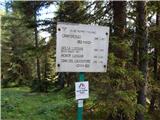 19
19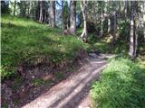 20
20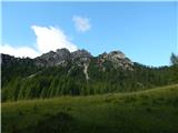 21
21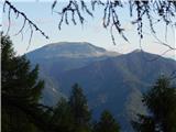 22
22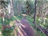 23
23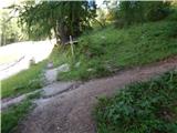 24
24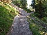 25
25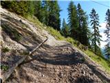 26
26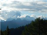 27
27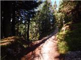 28
28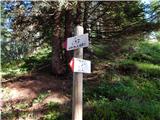 29
29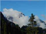 30
30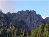 31
31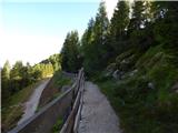 32
32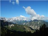 33
33 34
34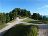 35
35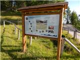 36
36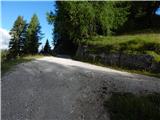 37
37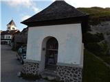 38
38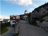 39
39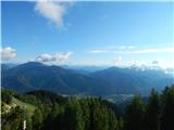 40
40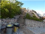 41
41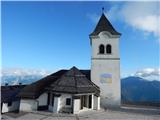 42
42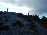 43
43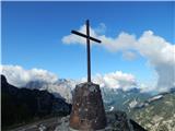 44
44 45
45
Discussion about the trip Žabnice / Camporosso in Valcanale - Svete Višarje / Monte Lussari
|
| Laščan17. 02. 2012 |
I'm interested in the condition of this trail, has anyone gone up on foot in the last few days and how will it probably be tomorrow on this trail?
Thanks!
|
|
|
|
| Laščan18. 02. 2012 |
Checked today! Morning -12, sky clear. Corresponding views right after the start. Normal walking, no crampons needed. At the top though .... Views clear all around, from Kamniti lovec to Veliki Klek. On the descent after 12 o'clock, we met groups of ski tourers, snowshoers and hikers. In short, a beautifully utilized day!
|
|
|
|
| Pohodnica562. 03. 2012 |
I'd also like to go tomorrow to move my old bones a bit. How long is the drive (approx) from Ljubljana to the starting point? According to Laščan's info, it's good to go early in the morning so there won't be too much crowd at the parking lot. Maybe someone knows what the trail from Zajzera is like currently?
|
|
|
|
| turbo2. 03. 2012 |
From Lj. it's about an hour and a half drive there. If the P at the start of the pilgrimage path is full, that's right under the hill, just leave the car at P under the road and you have max. 15 minutes walk more.
( I've gone very early and also very late from home and many times in between and it was always nice and rarely was the crowd such that it would be annoying  ) )
|
|
|
|
| AlainNovak8. 01. 2014 |
I'm wondering how this trail is in winter. Can it be easily hiked with mountaineering boots or is it advisable to have crampons or snowshoes?
|
|
|
|
| rovka8. 01. 2014 |
Definitely, it is more advisable to have snowshoes with you. The pilgrimage path through the forest above the Višarski stream gully is usually well-trodden due to numerous hikers and ski tourers. About half an hour before the summit, it follows the ski slope trail, where it can sink in at higher temperatures.
|
|
|
|
| IgorZlodej8. 01. 2014 |
From Višarska planina onwards, the hiking path has been newly routed since the year before last and does not run on the ski slope, but there are some types who walk on the ski slope, though I think the authorities quickly direct them off the ski slope.
|
|
|
|
| Lj8. 01. 2014 |
The pilgrimage path is usually even more trodden and "icy" due to numerous hikers and ski tourers, so based on my experience, small crampons (4- or 6-pointed) or "chains" from Verige Lesce are highly recommended. I have also seen hikers with snowshoes, which did not seem practical to me for that steepness. Good luck!
|
|
|
|
| kabe17. 01. 2014 |
Yesterday we were up there...the path, at least for us average hikers (+child) almost impassable... At the top about 80 cm of snow.
|
|
|
|
| Enka5. 06. 2016 |
What is this trail like in summer? Does it mostly follow forest paths or more forest roads?
|
|
|
|
| IgorZlodej7. 06. 2016 |
Usually nice, only last autumn it was muddy because they were doing timber extraction. But it's not a road, but a nice pilgrimage trail, somewhat steeper in certain sections.
|
|
|
|
| Enka8. 06. 2016 |
Oh super, thanks Igor, I was counting on you. We'll come check in summer .
|
|
|
|
| gigi67. 07. 2016 |
We are interested whether on 15.08. there is any Marian celebration and mass at the Višarje sanctuary, in Croatia it is a holiday so we would go up, thank you for any information
|
|
|
|
| rajko00287. 07. 2016 |
Of course there is celebration and holy mass - also in SLO it is Veliki Šmaren (Great Lady) a non-working day. There are at least three masses, first at 10.00 (9.30) 11.00(10.30) 12.00 (12.00 and 15.00) Times in brackets apply to Sunday and celebrations.
|
|
|
|
| gigi67. 07. 2016 |
Mr. rajko0028 thank you for the information and we will surely be up there that day for the celebration of the Great Lady.
|
|
|
|
| Priestess13. 08. 2016 |
hello... I'm wondering if you can get to the top by car or if you have to take the cable car in any case
|
|
|
|
| MANGRT13. 08. 2016 |
You can't/may not go by car. But the cable car is not the only option, because you can go by bike or on foot . .
|
|
|
|
| radagremvhribe21. 08. 2016 |
From the main road, turn left at the Davitt restaurant, Via Lussari, after a short climb we reach the parking lot, I walked along the dirt road, the path climbs steeply almost all the time, maybe it's not the same path?
|
|
|
|
| mornar7. 05. 2017 |
Please info on how the gondola runs. Lp.
|
|
|
|
| seflja8. 05. 2017 |
rubber boots on your feet and proper crampons then you're good to go
|
|
|
|
| darinka410. 05. 2017 |
It's really a via crucis. No switchbacks. Just straight up steeply. We did it once. Then I said I'd never go again.
|
|
|
|
| Petra54. 04. 2019 |
On Tuesday a wonderful day on Višarje. Crampons are recommended in the initial part of the path, otherwise an excellent snowy path for hiking. The gondola is not running, so everything was closed, but no one at the top. Paradise.
|
|
|
|
| Petra59. 12. 2019 |
Not yet a beautiful day up there. Already enough snow to walk nicely. Yesterday crystal-clear views.
|
|
|
|
| Marko Torelli10. 10. 2020 |
Hi...Today trip to Višarje...wonderful weather...and surprisingly few visitors...given the new Italian Covid measures we preferred to put on masks right at the border so the carabinieri wouldn't fine us...we walked without masks like everyone else...weather really summery before tomorrow's snow...nice regards
|
|
|
|
| tango18. 03. 2023 19:46:18 |
The trail is excellent, dry up to picture 9, snowy further on, in the lower part up to about the 8th station occasionally icy, further on the footing is excellent. Up without crampons, down with crampons. Given the excellent conditions at the ski resort, we decided to dedicate one day to skiing before it closes.
|
|
|
|
| Simona Mohar12. 04. 2024 09:01:20 |
Hello.
Next Saturday we plan to go on this path to the top of SV. Višarje. Is there any snow or ice on the path?
I'll be very grateful for a reply.
|
|
|
|
| PUHIPUHI26. 02. 2026 06:34:08 |
Is this path currently safe from avalanches?
|
|
|
|
| tango26. 02. 2026 21:52:00 |
Today my wife and I approached Višarje on this path. The conditions are excellent, but I estimate that the approach is easier with the use of crampons, although there were quite a few "hikers" without. It is true though that one already turned back on the first steep part. There were many touring skiers. The day was as if painted and therefore quite boldly.
|
|
|
To post a comment you must log in:
If you do not yet have a username, you must first
register.