Zadnjica - Pogačnikov dom na Kriških podih
Starting point: Zadnjica (642 m)
| Latitude/Longitude: | 46,38240°N 13,76040°E |
| |
Walking time: 4 h
Difficulty: easy marked way
Elevation gain: 1408 m
Elevation difference along the route: 1410 m
Map: Triglav 1:25.000
Recommended equipment (summer): helmet
Recommended equipment (winter): helmet, ice axe, crampons
Views: 305.551
 | 11 people like this post |
Access to starting point:
From Kranjska Gora drive over Vršič Pass towards Bovec or vice versa, but only to the 50th hairpin turn of the Vršič or Russian road (near the village of Trenta). Here turn onto the side road, along which after a few hundred meters park at the parking lot by the road.
Route description:
From the parking lot continue along the road, which takes us past a few houses, mainly weekend cottages, in about 15 minutes to the place where the road splits into two parts (there used to be a parking lot at the junction, today parking is prohibited).
From the old parking lot head onto the left road in the direction of Pogačnikov hut at Kriški podi (the right road leads towards Prehodavci and Dolič). After 15 minutes of further walking the road brings us to the lower station of the cargo cableway, where it ends.
The ascent continues along the marked hiking trail, mule track, which moderately ascends through the forest. The trail, ascending above the valley of Bela potok, quickly brings us to very steep slopes (danger of falling rocks), across which a wide path leads. The path then crosses the Veliki Presek gully, after which we reach a short exposed ledge, across which we pass with the aid of a fixed cable. Further on the path returns to the forest, where it moderately ascends in numerous switchbacks. A bit further the path brings us under a small overhang, where we can observe numerous sticks that hikers set up so the rock does not collapse into the valley (the sticks are placed more for fun than seriously). The path then crosses a few smaller gullies, then takes us past a chapel to a larger gully. With some caution (easy) we cross the mentioned gully, after which in a few minutes of further walking we ascend to a pleasant rest area (two benches along the path). Further we cross another large gully (possibility of snowfield in early summer), then the path returns to the forest. Higher up the forest becomes sparser, the path somewhat steeper and increasingly scenic.
The path, which continues ascending along the old mule track, then takes us past yet two benches into the dwarf pine belt, beyond which we pass into a more rocky terrain. Further we ascend over smaller screes, along an increasingly scenic path, which higher brings us to a pleasant spring (source).
Just a few dozen steps above the mentioned source, we arrive at an unmarked junction, where an unmarked path branches off to the right towards Lower Kriško Lake, which is a two-minute walk away, while we continue slightly left along the still wide alpine path. The path further leads us past smaller ruins, which we follow all the way to the marked junction, where the path from Vrata valley joins from the right. Continue left and after two minutes of further walking arrive at Pogačnikov hut at Kriški podi.
Just a few dozen steps above the mentioned source, we arrive at an unmarked junction, where an unmarked path branches off to the right towards Lower Kriško Lake, to which it is a two-minute walk, while we continue slightly left along the still wide alpine path. The path further leads us past smaller ruins, which we follow all the way to the marked junction, where the path from Vrata valley joins from the right. Continue left and after two minutes of further walking arrive at Pogačnikov hut at Kriški podi.
Starting point - To the clearing 0:15, To the clearing - lower cargo cableway station 0:15, lower cargo cableway station - To Utrci 2:00, To Utrci spring below Kriški podi 1:05, spring below Kriški podi - Lower Kriško Lake 0:05, Lower Kriško Lake - Pogačnikov hut 0:20.

Photos:
 1
1 2
2 3
3 4
4 5
5 6
6 7
7 8
8 9
9 10
10 11
11 12
12 13
13 14
14 15
15 16
16 17
17 18
18 19
19 20
20 21
21 22
22 23
23 24
24 25
25 26
26 27
27 28
28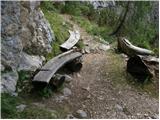 29
29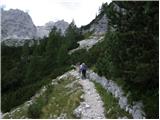 30
30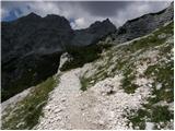 31
31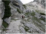 32
32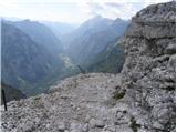 33
33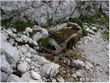 34
34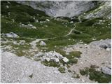 35
35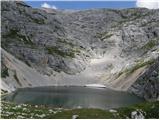 36
36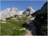 37
37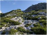 38
38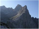 39
39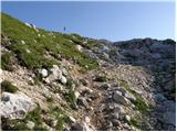 40
40 41
41 42
42 43
43
Discussion about the trip Zadnjica - Pogačnikov dom na Kriških podih
Show older messages
|
| Gost4. 08. 2006 |
Wonderful tour; also for smaller children. For animal lovers, there are charming ibexes, of which there are quite a few here.
Alenka
|
|
|
|
| Gost4. 08. 2006 |
But do those sticks support the rock so it doesn't roll into the valley or will someone bake corn there?
|
|
|
|
| Gost4. 08. 2006 |
Yes, you could bake them, but I'm afraid that then the rock will roll on me, then you can eat a pancake with corn filling.
|
|
|
|
| Gost21. 08. 2006 |
With a friend, I bet who placed the STICKS under the rock. Themselves after the snow melted, or hikers for...
|
|
|
|
| Tadej22. 08. 2006 |
And who won the bet? The one who bet that hikers built them for fun!!! I built some too!
|
|
|
|
| Gost22. 08. 2006 |
Thanks Tadej.
After this I won the bet myself, although I thought maybe for kindling a fire.
|
|
|
|
| Gost26. 05. 2007 |
interesting
|
|
|
|
| Gost12. 06. 2007 |
The path to the hut is interesting as you see nothing but beauties along the way. Waterfall, gully, chapel, cableway, lake and view. Recommended.
|
|
|
|
| TinaPRR25. 08. 2008 |
Nice route Worth doing another from here when you're already so high Worth doing another from here when you're already so high
|
|
|
|
| reina28. 09. 2008 |
I was up there two weeks ago. In the hut there are fantastic young people. Even though all overnight capacities were taken, they still provided for us latecomers. Thanks to them.
|
|
|
|
| urosl26. 07. 2009 |
Great trip! We were up there today. From Zadnjica we walked 2:45h, fantastic weather, good bean soup, jota and pancakes and very friendly people at the hut!
|
|
|
|
| petruša23. 08. 2009 |
We were up two weeks ago, also 9 and 10 year olds. Especially interesting for kids when an ibex was in front of us. Very nice even with fog up top. Suitable tour for family with children.
|
|
|
|
| Ljubljana24. 09. 2009 |
Trip rating - 5! Long ascent with magnificent views. I recommend it too!
|
|
|
|
| vesna.p25. 03. 2010 |
Phenomenal, I recommend it to everyone
|
|
|
|
| spotonbody26. 05. 2010 |
Can anyone provide info, I'm interested in current conditions on the path, especially how much snow is left and how much is trodden and suitable for visiting. Thanks, best regards
|
|
|
|
| spotonbody24. 06. 2010 |
14.06. the path was completely dry except for one snow patch. nice path suitable also for youngest hikers who with a bit of luck can be delighted by chamois wild goats and ibex along the way
|
|
|
|
| modrook1211. 07. 2010 |
I'm wondering how long it takes from Pogačnikov dom to Razor. Thanks, best, Franci
|
|
|
|
| Gorazd G11. 07. 2010 |
Two hours. (Officially)
|
|
|
|
| GregorC11. 07. 2010 |
Yesterday I went up from Zadnjica. Really nice path, with magnificent views of the neighboring peaks and the Trenta valley. The path is fine. It was extremely hot though. Thank goodness we started early enough to do most of the ascent in the shade, the descent passed in scorching heat, so it exhausted me much more than the ascent. Otherwise a super tour. And praise to the hut staff. They are very friendly.
|
|
|
|
| NEIC00812. 07. 2010 |
Friendly yes, but they want money IMMEDIATELY before you drink or eat anything.. 
|
|
|
|
| BARMETAL26. 07. 2010 |
Wonderful tour, friendly caretakers, ibex, marmots, edelweiss.... in short, an unforgettable trip, which unfortunately ended with a bitter aftertaste. At the "parking lot" in Zadnjica, a notice from the traffic warden was waiting on our car. Horror!!!! There were more than 20 vehicles parked, including many foreigners, of course all with warden notices. The indignation was indescribable, as this area is marked everywhere as a parking lot (also in the path description above). Apparently they changed the signs recently, so you have to be very careful, as there is no no-parking sign even before the "parking lot", but it is placed about 2 km lower along the road, shortly after the turnoff from Vršiška cesta. So be careful, as this is a big source of income for the authorities!!!!!!! We are people of tourism!!!!!
|
|
|
|
| BARMETAL26. 07. 2010 |
Wonderful tour, friendly caretakers, chamois, marmots, edelweiss.... in short, an unforgettable trip, which unfortunately ended with a bitter aftertaste. At the "parking lot" in Zadnjica, a notice from the traffic warden was waiting on our car. Horror!!!! There were more than 20 vehicles parked, including many foreigners, of course all with warden notices. The indignation was indescribable, as this area is marked everywhere as a parking lot (also in the path description above). Apparently they changed the signs recently, so you have to be very careful, as there is no no-parking sign even before the "parking lot", but it is placed about 2 km lower along the road, shortly after the turnoff from Vršiška cesta. So be careful, as this is a big source of income for the authorities!!!!!!! Tourism, we are people!!!!!
|
|
|
|
| Bizy26. 07. 2010 |
Don't joke, is it really like that. And where is the parking lot now? By the main road or where? We'll have to walk even more on foot up the gravel road.
|
|
|
|
| heinz26. 07. 2010 |
Where – two kilometers lower along the road after the turnoff from Vršiška cesta? I didn't see it. On Friday I received a "Notice".
|
|
|
|
| turbo26. 07. 2010 |
No-parking sign is there, free parking too, wardens are a staple, as are the fines. A lot has been written about this on this portal in another forum. Unfortunately, that's how it is and we'll have to adapt. Just like for Tamar. And from Planica to Tamar is farther than from the "new" parking in Zadnjica to the barrier.
True, we are people of tourism. Abroad I haven't seen (Switzerland, Austria, Italy) parking at mountain trailheads where it's not allowed. Parking in Vrata must be paid, likewise on Planina Blato, at Savica, on Vršič, in Logarska dolina. In Zadnjica it's still free, just park a bit earlier and walk half an hour more.
And one more thing. Last year there were several car break-ins right at the barrier in Zadnjica. Also in Zadnja Trenta. Believe it or not, the police have preventively visited those areas several times. And right in Zadnjica they couldn't even turn around (with the van), because everything was parked haphazardly up to 120 vehicles!!! Not to mention that locals living above the barrier often couldn't open it because of an awkwardly parked car in front. And transporting wood from the end of Zadnjica to the valley... sometimes at the barrier everything was so parked that you had to fold in your mirrors to sneak out of the valley on the road. And a truck or tractor with wood?!? Yes, it's true, locals there work hard often also on Saturdays and Sundays. Or Fridays and holidays. Wardens don't just care about "fines", they also chase those who litter, light fires in nature, camp illegally and such. And probably more.
|
|
|
|
| VanSims26. 07. 2010 |
In foreign countries, it is precisely and explicitly marked where parking is allowed and where not. I've never had a ticket abroad for parking somewhere not forbidden (and of course in accordance with traffic rules). But you get one quickly if you park where it's explicitly prohibited or don't pay the fee... They often tolerate it if the car is parked against the rules but doesn't obstruct anyone.
Not like here in Zadnjica (something vague or one sign at the beginning, which you can easily miss or forget after two km) or in Bohinj, where you don't know you can't park outside paid parking spots (still in accordance with regulations) and you get a ticket.
With all respect to the hard work of the locals, setting traps (deliberate non-signage or vague and unclear signaling) and then fining is Balkan-style.
They should clearly write on the parking lot in Zadnjica that parking is prohibited and possibly put up another sign there. In Bohinj too, the parking regime should be explained at the city entrance and/or all no-parking spots marked. Then they can fine as much as they want. That would be Europe!
|
|
|
|
| viharnik27. 07. 2010 |
In this Slovenia, I'm really surprised by individuals from Gorenjska local communities who arbitrarily set traffic rules in valleys, passes, and lakes. Such behavior is not observed abroad, as tourist locals there know how to behave towards tourists in their areas. If a tourist is treated merely as a consumer from the start and welcomed heartlessly and disrespectfully, he will soon blow away elsewhere. But if welcomed with warmth and homeliness, the tourist himself will be more open to exploring the landscape, cuisine, natural sights, sports, etc.
The Val d'Isère area has many mountain parking lots above 2000m, but it doesn't occur to them to have a cashier at the end by the parking lots. There's only a small parking lot near the town in the sports valley with barriers and an automaton (probably for winter when plowing, now in summer even that is open, free). Everything is free, you simply park and go to the mountains. Even in conversation with locals about parking in valleys, they themselves say they haven't noticed complications with tourist parking. Also, Kleine Bernardo pass 2188m, Col de Mt. Cenis 2083m, and Col de l'Iseran are completely free of fees and parking up there. Even souvenirs at that altitude aren't overly expensive (the ceramic mug I bought was only 3€ more expensive at the 2770m pass - 18eur).
In conclusion, I think like turbo said. Let the municipalities finally unite in this small Slovenia (otherwise we'll become ridiculous) and close the traffic-disturbing sections with barriers, arrange the other parking lots and mark them with a P sign, so it's clearly recognizable and not duplicitous, leaving many in doubt as it is now.
|
|
|
|
| strelec195427. 07. 2010 |
Such twisting of regulations really leads nowhere. It might sound strange, but that's why I've decided not to go to the Bohinj area for several years; they chased me away with parking fees at every corner. It's not about that euro, but the manner...
Let them once ask themselves if they would behave like that everywhere in the country and set up barriers. For example, every morning when they drive to bigger cities for work, they create traffic jams and even more stink—does that sound strange???? If I start thinking like them.
|
|
|
|
| lepenatka27. 07. 2010 |
So there's nowhere to park for Zadnjica. As far as I remember, along the road after the exit from Vršiška cesta, there are no parking spots.
And where should I leave the car on Saturday
|
|
|
|
| turbo27. 07. 2010 |
Lepenatka,
when you turn from asphalt to gravel towards Zadnjica, after about 10 meters on the right there's a large gravel parking lot. Leave the car there. If you don't like it there, then in the village Na Logu next to the info object - TNP museum, there's also a good one. And there's even a tavern right nearby for the way back.
|
|
|
|
| BARMETAL27. 07. 2010 |
DEAR TURBO ALSO ON POKLJUKI THERE ARE SO-CALLED UNMARKED PARKING SPACES, AND I HAVEN'T HEARD OF ANYONE GETTING A FINE FOR PARKING THERE, ABOUT THE BARRIERS BEING PARKED I AGREE LET THE WARDEN FINE THOSE WHO OBSTRUCT SMOOTH PASSAGE, WHEN I GOT THE FINE I ASSURE YOU THERE WASN'T EVEN ONE PARKED SO AS TO OBSTRUCT PASSAGE THROUGH THEM
GOOD LUCK
|
|
|
|
| turbo27. 07. 2010 |
On Pokljuka (under Lipanca, Rudno Polje, Mrzli Studenec...) there is no traffic sign "No parking", but in Zadnjica there is. When they changed the traffic regime in Tamar, no one got upset, even though it's about an hour's walk from Planica there. And the situation in Planica is the same, sign prohibiting entry to Tamar, no barriers anymore, but if you drive further, it's very likely you'll pay a fine (last year 40€).
Anyway, each to his own, thank God. For tours from Tamar, I've already added plus one hour up and one hour down to the tour last year, and it somehow works out for me. It's true that I prefer going to Tamar in winter, when you can't drive there anyway. And in winter, you often have to park much lower in Logarska Dolina than in summer, but you can still do nice day tours. And there are quite a few similar examples. What I'm writing has nothing to do with the parking regime, I just want to say that it's not exactly necessary to drive to the starting point and park a meter or two from the start of the hiking trail. At home and abroad, when I go to the mountains, I follow the principle: by car as far as allowed, not as far as possible. And it works out for me somehow...
|
|
|
|
| lepenatka27. 07. 2010 |
Turbo, thanks. The first option will be fine
The tavern also comes in handy - on the way back.
Safe steps and lots of enjoyment I wish.
|
|
|
|
| Klemenko23. 08. 2010 |
My wife and I also had a good time on this tour over the weekend. Saw some chamois, watched ibex on the way to Gamsovec (why not Kozorogovec?). Slept in a packed hut, but the young (and capable) crew managed well. Thanks! Food also super (sachertorte with Sunday lunch!). Since not mentioned: we carried drinks from the car excessively. Up to 1300 m you can refill water (currently!) three times. First at the cable car station, once in between, at ca. 1300 need to go 10 m up from the path along the stream. Then tap below Spodnje jezero (1850 m? - correct). In between really scorching sun if hiking in the afternoon. Hat essential. Kriški podi are anyway magnificent and really the right starting point for summits.
This time rangers could really "earn". Thank God they didn't, also for us, as everything was full.
|
|
|
|
| geo925. 08. 2011 |
yesterday the rangers earned well again, so don't rely too much on them maybe not being there this time 
|
|
|
|
| marjana2. 09. 2011 |
Where do you have to park the car so that the wardens don't fine you? Is there perhaps a new parking regime? In early July we parked at the parking lot by the ramp.
|
|
|
|
| rjudnic2. 09. 2011 |
there where the "P" sign is, as far as I know the sign is only at the entrance to the valley
|
|
|
|
| turbo2. 09. 2011 |
You have to park immediately when you come down from the asphalt, or approx. 50m further. On the right are large gravel parking areas. Further ahead on the right side is a house, just before the house a no-parking sign that applies all the way to the barrier.
|
|
|
|
| Tomažke2. 09. 2011 |
Turbo, are you sure it's like that? When I recently went to Triglav I also parked right away on the gravel parking lot. From there to the ramp it's another 10 minutes walk, and there it's always full of cars. That no parking and stopping sign is placed a bit ambiguously. It's right in front of the driveway to that house, if I'm not mistaken...
|
|
|
|
| dm7212. 05. 2012 |
After a long time back a bit to the mountains. This time I chose Pogačnikov dom na Kriških podih. Start from the parking lot in Zadnja Trenta still in the dark and I was at the hut before sunrise. Weather excellent. Views superb. The lake is still encased in ice, snow practically gone.
|
|
|
|
| mirjam6730. 06. 2012 |
Yesterday, after many years, I was back at Kriški podi. Since I read these comments about parking at the ramp, I called TIC Bovec and asked them about it. They gave me the phone number 05 38 89 330 (TNP) to ask there. A friendly lady answered and said that parking at the ramp is indeed prohibited and that the parking lot is right after you turn off the asphalt into Zadnjica. That's where I left the car. It's a good 10 minutes walk to the ramp. There were at least 10 cars parked at the ramp. It seems the warden isn't working yet, as none had a ticket on the windshield. And why is parking no longer allowed? Because there's a water reservoir there for Bovec and because sometimes cars blocked the gate so emergency vehicles couldn't pass.
|
|
|
|
| urbancek30. 06. 2012 |
Yeah, is it such a sin to walk those extra couple of minutes? That's how it is, that's the regulation and it's right to gradually abolish "wild" parking lots...
Let the others drive if they want, even to Pogačnik...
|
|
|
|
| jax1. 07. 2012 |
Here, since you're asking, I'll answer. Yes, I see no reason to prohibit traffic in the VALLEYS. People have always lived and operated here, and roads have been present for a long time, so I see no reason to close them. And maybe Zadnjica is indeed a less extreme case, but with that foolishness in Tamar, quite a few tours (not to mention climbing) have become very difficult to do in one day. Of course, we can moralize and claim that you need to take who knows how much vacation and walk at least from Rateče, if not already from Jesenice, but I firmly state one thing: all those who claim that you need to park as far from the hills as possible, experience them "from the foothills" and walk as much as possible even in the valleys, are mostly those who don't like real mountains at all. Simply - such "additions" to long tours are generally unnecessary for mountaineers, and if traffic were properly regulated, they wouldn't be needed either, and yet no one would be worse off.
|
|
|
|
| joža x1. 07. 2012 |
Don't judge others by yourself. Those who really love the mountains (REALLY) will do more to leave as few "traces" as possible. Everything else is bla, bla......
|
|
|
|
| Irina1. 07. 2012 |
@jax,
where are the times when we got off in Mostrani and off we went on foot to Vrata or from Rateče to Jalovec. We also cheerfully walked from Bohinj along the lake and then on. Do you know where the start for Krn was? The bus dropped you on the Bovec road and you already had a good chunk of the way to Lepena, let alone to the summit. But we went. No problem, no complaining. In those student years none of us had a car, what car, but that wasn't a problem. We looked forward to nice weather and the time we spent together in the mountains.
Today we've gotten a bit spoiled and most would like to drive right under the wall. Is that still hiking or just rushing to conquer the summit as quickly as possible and return even faster to the city concrete?
You have to take time for friends and mountains!
|
|
|
|
| jax1. 07. 2012 |
Irina: none of you would do it if not necessary. Reading Mihelič's 1991 guide, I see that in many places one could drive even further (if one had a car). Some restrictions make sense, perhaps even in Zadnjica. But others are downright mad and explicitly hinder tours, like Tamar and Kamniška Bistrica.
joža: come on. And how do I leave traces by driving to where THE ROAD ALREADY EXISTS? I'm not advocating off-road on tracks, but using what's already there...
|
|
|
|
| Branee1. 07. 2012 |
@jax seems you don't grasp some things, e.g. today 100x more traffic than before and this road not made for thousands of vehicles weekly. Past: occasional car, nonstop traffic: no peace for animals, neglecting space. Ever seen grass/veg by road vs no traffic? Often vital for wildlife, is your tour vital?
Secondly, always plan tours. Thank God not allowed, already neglecting all Slovenian, now the last (nature)?
|
|
|
|
| urbancek1. 07. 2012 |
Of course need access deep into valleys (many reasons), but direct to organized parking. Latest example Jezersko: large organized parking created, before parked between tree trunks...
|
|
|
|
| KARLEK31. 08. 2012 |
Hello!
On Monday morning (around 10 am) I'd like to go to Pogačnikov dom from Zadnjica. Since it's my first time on this trail, I'm interested in the actual difficulty level for walking, given that I have partially torn knee ligaments again (old injury). And what's the weather forecast? With the front passing over the weekend, is there also a chance of snow announced, and what does that mean for walking this trail? Thanks for the answers despite (probably some) strange questions.
|
|
|
|
| Zebdi31. 08. 2012 |
Well, difficulty level... technically not demanding, it's more or less a walk. There are no extra steep sections on the trail. Condition-wise, you know best yourself how capable you are. For the weather forecast, it's best to check ARSU.
|
|
|
|
| Daaam31. 08. 2012 |
The elevation difference is known, so you have to reckon with descending for quite some time (knees), but you always have to check the weather yourself (it's really not smart to ask on the forum what it will be like).....as for snow,...if it falls and you're not prepared, then turn back..
|
|
|
|
| pupek10. 07. 2013 |
Hello! I'm interested in how long the walk is from the bus stop to the starting point and where the path goes if anyone knows.
|
|
|
|
| miri10. 07. 2013 |
Half an hour, everything else is written down. Have a nice tour.
|
|
|
|
| pupek10. 07. 2013 |
thank you very much for the reply
|
|
|
|
| pupek11. 07. 2013 |
Hello!
I'm also interested in what the bus station is called.
|
|
|
|
| SuzanaM11. 07. 2013 |
The driver stopped for me right at the bend where the road to Zadnjica branches off.
The bus station is in the village of Trenta, to the 50th bend of the Trenta-Vršič road (from Trenta village it's the first bend) it's then about 5-10 minutes walk.
|
|
|
|
| SuzanaM11. 07. 2013 |
From the village of Trenta to the 50th serpentine you go along the main road, further along the Zadnjica valley on the gravel road.
|
|
|
|
| pupek11. 07. 2013 |
Thanks for the answers but is the path hard to find from the station in Trenta to the starting point
|
|
|
|
| SuzanaM11. 07. 2013 |
No problem. Just along the main road to Vršič. At the first bend (i.e. 50th hairpin bend of the Vršič road) there is a big sign for Zadnjica.
|
|
|
|
| SuzanaM11. 07. 2013 |
And one more thing. In the Avriga and Alpetour timetable the station name is Trenta.
|
|
|
|
| pupek11. 07. 2013 |
Many thanks to everyone for the answers
|
|
|
|
| ih_hihi5. 08. 2013 |
Hi, is it possible to hike this trail with a dog? thanks for answers =)
|
|
|
|
| capraibex5. 08. 2013 |
In these hot days a dog doesn't belong on such a long tour, exposed to the sun.
|
|
|
|
| Grenaleva13. 08. 2013 |
Yesterday we returned from that beautiful hike. At the hut it was already quite cold late in the afternoon. We extended the trip to Križ, which offers a beautiful view of the highest Julijce. I'd like to warn you to respect the no parking sign in the valley, as yesterday all cars parked before the barrier (about 20 of them) got a fine from the inspectors - 160 €.
Otherwise a nice path. From Zadnjica, right at the junction, count a good 4 hours.
|
|
|
|
| Monika819. 08. 2013 |
Hello! This week I'm heading to Kriške pode for the first time, and I'm wondering if a helmet is necessary. I noticed it's listed in the equipment. Thanks.
|
|
|
|
| LunaMars19. 08. 2013 |
Hello. We hiked the path as a group last week, the path is really easy and well-marked, it drags a bit, that's all... great starting point for continuing to Križ, Bovški Gamsovec or Stenar. No helmet needed to Pogačnikova hut, just some fitness and proper footwear. And don't forget sufficient drinks. Enjoy the trail.
|
|
|
|
| Monika819. 08. 2013 |
@ LunaMars
Great, many thanks for the reply.
|
|
|
|
| andro-id23. 01. 2014 |
I'm interested in how much overnight stay costs at Pogačnikov dom (adults, children)?
|
|
|
|
| tinky23. 01. 2014 |
By June when they open it you'll already know
|
|
|
|
| laik28. 10. 2014 |
I'm interested, what are the conditions on Kriških podih... is there any snow? thanks a lot and greetings to all.
|
|
|
|
| ana13. 08. 2015 |
Yesterday I arrived from Kriške pode to Zadnjica. Luckily I had arranged transport because of the circular tour, otherwise it would have ended badly. Along the entire Zadnjica up to the parking lot at the beginning, there were at least 50 cars ticketed by the inspectors, mostly foreigners and a couple of ours. Apart from a no parking sign somewhere at the beginning, we didn't notice any special notices.
This is plain municipal banditry. On one hand, these people shout that they are forgotten by the world and the state that doesn't allocate enough funds to them, but those who come to them as tourists they calmly slaughter for a one-time profit.
Where do they even have any logic regarding tourism? As if those Hungarians, Germans, Dutch etc. came from so far just to see something that isn't anywhere else in the world??? They have to sleep, eat, drink and spend money somewhere. Probably they will never return to Trento. There they can shout again that the whole world forgets them except for two summer months. In the long term, it will ruin them for the whole year and quite rightly so
|
|
|
|
| malimiha26. 08. 2015 |
Hi,
I'm interested in how much walking there is from the hut to Vršiča. If I'm correctly informed there are two paths, one easier and one more demanding? Best Miha
|
|
|
|
| buda128. 08. 2015 |
approx 5-6 hours via South path, via Jubilee path add another "thick" hour.
The South path is easier than the Jubilee one, both paths are very demanding...
|
|
|
|
| Kruli221. 09. 2015 |
Remove the license plates and let them write you a fine ...
|
|
|
|
| ajax1. 09. 2015 |
that's because of the locals' or weekenders' parking. if there's a sign at the beginning it's at the beginning and it's right that they pay.
|
|
|
|
| B21. 09. 2015 |
Kruli22, bravo! Good idea!
|
|
|
|
| mirank1. 09. 2015 |
I often go to Italy and there these things are arranged. You have a sign and a barrier and an organized parking lot, end of story. Sometimes parking is charged and no one finds it strange.
But this in Zadnjica is pure hypocrisy with that sign. They would earn more if they tidied up the road and parking a bit and then charged for it. Everyone would rather pay than at the end and also at the start, walk on the road.
|
|
|
|
| Zebdi2. 09. 2015 |
In Slovenia too, things are well arranged. The parking is marked both in nature and on the hiking map, but apparently that's not enough for some
|
|
|
|
| mirank2. 09. 2015 |
That the parking is arranged is true, how it is is another story. What bothers is a clear sign prohibiting traffic ahead and a barrier and also some information board next to it
|
|
|
|
| jax2. 09. 2015 |
If my memory doesn't deceive me badly, there is a perfectly clear sign at the beginning of the road. But there really is no barrier. Personally, I think there's no need for such strict traffic regulation (the parking lot in the middle of the valley was quite ok), but I can't agree that it's not clearly marked. Well, I allow the possibility that the sign was removed since last year. I haven't been there this year yet.
|
|
|
|
| jax2. 09. 2015 |
Aha, and barriers aren't everywhere in Italy either. But there somehow the prohibition sign is respected.
|
|
|
|
| mirank2. 09. 2015 |
If I remember correctly, there was indeed a very clear sign prohibiting stopping and parking; from here on no comment
|
|
|
|
| planika822. 09. 2015 |
The sign prohibiting stopping and parking is of course still there (visible from picture 2) and it's there on purpose to be obeyed. As the first Zebdi, the parking is marked both on site and on hiking maps. I don't know what's wrong with the parking lot or how it should be arranged differently? If there's a sign with a clear meaning of prohibition, no ramp is needed.
|
|
|
|
| jax2. 09. 2015 |
Come on, copy-paste the whole thing. The link is not nicely summarized.
|
|
|
|
| gorska_jožica20. 04. 2016 |
Hi, end of next week we plan to go to Pogačnikov dom via Zadnjica. Does anyone know what the conditions are like? How much snow is there?
Thanks and best regards!
|
|
|
|
| nordkap25. 06. 2016 |
Hi,
I plan to take this trail soon. I'm wondering about the current parking situation; I understand you can't park at the old spot, but can you park without issues or fines at the indicated starting point, or as in picture 1.
So that I don't ruin the whole nice hike upon return.
Thanks for the info.
|
|
|
|
| mirank25. 06. 2016 |
That is the official parking lot, you can't go any further anyway, as they have installed another barrier.
|
|
|
|
| nordkap25. 06. 2016 |
Thanks for the reply, I wouldn't go further anyway, just that it's the spot so I don't get a ticket. If the trail gets longer, I don't mind at all, because I like walking.
Thanks.
|
|
|
|
| tofant6711. 08. 2016 |
This weekend we're heading to Kriške podi. Is it possible to park a 7-meter long motorhome at the parking lot? I'm also interested if the path is suitable for a small dog used to long walks. lp and thanks for your opinions
|
|
|
|
| B212. 08. 2016 |
At the (new) parking lot before the barrier there is enough space even for a bus. From the Zadnjica valley to Kriške pode a comfortable mulattiera leads, walking time is about three hours. Whether your dog can manage this path you have to judge yourselves...
|
|
|
|
| to68ne17. 08. 2016 |
Hello!
This or next weekend I'm heading (weather permitting) to Kriški podi, specifically from Zadnjica. However, I plan to do a loop: Zadnjica-Kriški podi-Bavški gamsovec-Luknja-Zadnjica. I reckon it's about 10 or 11 hours of walking. Can you help with the actual time for this loop?
thanks
|
|
|
|
| miri17. 08. 2016 |
That's accurate, it should hold. If you run into a herd of chamois, it might extend by a couple of minutes.
|
|
|
|
| Branee17. 08. 2016 |
I went down your route from BG in 3 hours to Zadnjica.
|
|
|
|
| darinka417. 08. 2016 |
From Zadnjica to Luknja is 4.5 hours at a more normal pace without racing.
|
|
|
|
| Branee17. 08. 2016 |
Come on, 4.5 hours to Luknja is 2 hours for a fit person.
|
|
|
|
| Smetar17. 08. 2016 |
If you "step on it" it's actually about 7h walking without breaks Otherwise that time will hold (10-12h), total almost 21km and 1850m ascent.
|
|
|
|
| miri17. 08. 2016 |
Buddy, multiply your age by two, add 10 and then comment.
|
|
|
|
| Branee17. 08. 2016 |
Yeah, how should I know how old he is
|
|
|
|
| to68ne17. 08. 2016 |
Big thanks to everyone for the help and answers. I'm 48 years old but going with family, so the trip might take a bit longer time-wise, but I'm sure it will be nice and unforgettable. Yeah, looking forward to meeting a chamois, both the four-legged one and the 0.5l one.
thanks again for the help
|
|
|
|
| dolce1. 09. 2016 |
Hello, can you advise on footwear, are mountaineering boots necessary for the path to Kriške pode or are hiking/higher shoes sufficient?
|
|
|
|
| zokica1. 09. 2016 |
Ha... it's like asking if you need swim trunks at the sea. No you don't - you can be in your underwear or without.
|
|
|
|
| Ljubljana1. 09. 2016 |
What's the difference between mountaineering boots and hiking/higher shoes?
|
|
|
|
| dolce1. 09. 2016 |
Mountaineering boots are mountaineering boots, hiking shoes are just a bit more robust sports sneakers...
|
|
|
|
| ZOJA9. 09. 2016 |
Hello, please can someone tell me if there is any water at the hut or in the hut... drinkable or not.
best regards
|
|
|
|
| simon799. 09. 2016 |
The water is of course drinkable (where else, if not up there). Usually in the hut, no problem. There is also water nearby ca. 20 minutes before the hut from Zadnjica direction (trough, plenty of water). Or on the path from the hut onwards to Križ/Škrlatica, good 5 minutes from the hut - there is a barrel and pipe that supplies water to the hut...
|
|
|
|
| ZOJA9. 09. 2016 |
Thanks for the useful information.
lp
|
|
|
|
| andrejam21. 09. 2016 |
Excellent hike. At 7:30 I started at the "barrier", by 13:00 I was already on the way to Vršič. At the hut there was a snack and well-deserved Radler
|
|
|
|
| miri21. 09. 2016 |
@simon79, don't be so sure about the water purity. The Upper Kriško Lake is one of the most polluted lakes in Slovenia.
|
|
|
|
| jprim21. 09. 2016 |
@Dolce gojzarji are hobnailed boots. I think the times when gojzarji were worn on mountain hikes are over.
Lp
|
|
|
|
| vanya3. 08. 2017 |
I've read so much about this parking, I'd rather ask once more how it is this year? Are the radars still chasing and issuing tickets?So where exactly to park now if going from Zadnjica to Kriške?
|
|
|
|
| mirank3. 08. 2017 |
As far as I know, they no longer issue tickets, because you have no choice-they have installed a barrier.
|
|
|
|
| Enka3. 08. 2017 |
You park almost immediately after turning from the Vršiška road into Zadnjica, maybe 200m after the bend.
|
|
|
|
| vanya7. 08. 2017 |
Thanks to both for the info.
|
|
|
|
| vanya7. 08. 2017 |
Oh, one more thing I'd ask, if you overnight up there, probably nothing wrong if you leave the car there in front of the barrier?
|
|
|
|
| darinka47. 08. 2017 |
Better not leave the car in front of the barrier. Leave it down below. There is plenty of parking.
|
|
|
|
| turbo8. 08. 2017 |
Parking in front of the gate is prohibited mainly because there is a water intake there!
|
|
|
|
| vanya10. 08. 2017 |
ok. thanks for the info. we'll leave it at the parking lot.
|
|
|
|
| FSkok3. 08. 2018 |
Is the information about drinking water along the path current?
|
|
|
|
| tfajfar3. 08. 2018 |
Water is available.
@admin (correction of the trail description)
The junction to Malo Kriško jezero is (now) marked.
|
|
|
|
| FSkok3. 08. 2018 |
Thanks for both useful pieces of information,
best regards, Franci
|
|
|
|
| FSkok3. 08. 2018 |
Thanks for both useful pieces of information,
best regards, Franci
|
|
|
|
| FSkok3. 08. 2018 |
Thanks for both useful pieces of information,
best regards, Franci
|
|
|
|
| miratan10. 09. 2019 |
Hello,
does anyone know approximately how much time the route from Pogačnikov dom na Kriških podih would take, via Dovška vratca, Bovški Gamsovec to Luknja, via Plemenice, Triglavsko škrbino to Triglav?
|
|
|
|
| bo_zl10. 09. 2019 |
Signpost at Dovška vratca says: Pogačnikov dom 30 minutes, Luknja 2 hours 30 minutes.
Signpost at Luknja: Triglav 4 hours.
Total therefore 7 hours, how much faster you are than these times you know yourself.
|
|
|
|
| miratan12. 09. 2019 |
Greetings again. Is safety equipment needed via Plemenice, as I hear that the fixed cables are only sparsely placed? regards
|
|
|
|
| darinka412. 09. 2019 |
Helmet definitely. At the beginning and in the last gully you can use the via ferrata set.
|
|
|
|
| Emiljano17. 07. 2020 |
On Wednesday, July 18, three hikers went on a trip from Pogačnikov dom to Luknja, Dolič and back to Trenta. Someone tried to break into the car at the parking lot. PZS, police or I don't know who should do something, as break-ins at this parking lot apparently repeat.
|
|
|
|
| Emiljano17. 07. 2020 |
Pardon, the date is wrong. We went on the mentioned trip on Wednesday, July 8.
|
|
|
|
| KMiha18. 07. 2020 |
Hello Emiljana, we met at the hut, chatted and drank a beer or two Did you manage to reach Gamsovc?
|
|
|
|
| Emiljano31. 07. 2020 |
Hello Miha!
Yes, with a 10 kg backpack we managed to climb Bovški Gamsovec. I was very happy, as a few years ago I got scared of heights twice. This time I succeeded, I followed my mountain guide's rule..."Look only where you will step and hold on. What's down there doesn't interest you". But I must not look into the depths, because fear of heights appears. When climbing down it's of course harder to do that.
Happy trails in the mountains ahead!
|
|
|
|
| Pušjakec5. 08. 2020 |
Hello,
this week I'm heading to Kriške pode and I'm just curious about the condition of the cables on the path. Safety comes first, especially for an inexperienced hiker
Thanks for the reply and best regards
|
|
|
|
| jax5. 08. 2020 |
On this path? Well, yes, down at the crossing of one gully there is even a cable - and it's in good condition there. Otherwise, it's a mulatiera ...
|
|
|
|
| GregorD6. 08. 2020 |
The path is very comfortable and "cool" in the morning hours. As the previous poster wrote, there's only one spot where the path is narrow and slightly exposed. The cable in that section is OK.
Just watch your step.
|
|
|
|
| glorija1. 09. 2020 |
Hello,
Recently I visited this path for the first time, which leads to Kriški podi and further to Razor... I must praise the young staff who skilfully and friendly served food and accommodation in the hut, a great example to all other huts where I haven't experienced this... I'll return, bravo young ones... safe steps to all and good luck..
|
|
|
|
| Robyt30. 11. 2020 |
Today's hike done. Morning frost in Zadnjica was pressing, but on the way we warmed up properly. At the hut, the sunshine welcomed us. Perfect day, complete calm and sunshine that really warmed the old bones, and we were alone up there. We also jumped to the lake on the way down, frozen but still magical. A chamois accompanied us on part of the path. Really ideal day. Snow is forecast for the day after tomorrow.
|
|
|
|
| jugo.kis@gmail.com19. 12. 2020 |
I got to the hut at Kriške podi from Vrata valley via Sovatna from where there's a great view of Triglav. Since I had leg cramps, I didn't go further to Razor but stayed overnight at the hut and went back the next day via Sovatna to Vrata. My friend Beno went to Razor, I waited for him at the hut. Next time I plan to go to Razor from Zadnjica valley in Trenta when I'm better prepared for 10 hours of walking.
|
|
|
|
| miratan15. 06. 2021 14:10:01 |
Hello
I would like to take colleagues from Zadnjica to the hut at Kriške podi. Has anyone been there in the last few days?
I'm interested if the snow has melted and there are no more snow patches on the path?
Thanks
|
|
|
|
| SSpak27. 06. 2021 20:06:27 |
One of the gullies that the path crosses is still covered with ice. There you need to walk over the ice or cross the gully lower down along the streambed, which requires descending the spur and climbing back to the path. Today (27.6.) around 8:00 the ice looked quite solid, so we went over it, in the afternoon the heat had already seriously undermined it and I think it's no longer safe for crossing. Better to wait a couple more days until all the ice melts.
Higher up the path there are a few snow patches that can be nicely crossed even without poles.
The lower lake is also partly still covered with ice.
|
|
|
|
| izi7928. 06. 2021 13:58:36 |
SSpak, I'm curious in case you cross the gully what kind of descent is needed? How much lower and how demanding (steep) is it?
|
|
|
|
| SSpak28. 06. 2021 16:19:27 |
For an idea - the path is visible in picture no. 24, ice covers the reinforced path through the torrent bed, you need to take that path on the right, descend a few meters along the grassy ridge and go over the lower rocks. If I look closely at the photo, there's a path on the right that you need to take.
Anyway, a couple more days of this heat and there won't be any snow left.
|
|
|
|
| osa18. 07. 2021 12:13:12 |
I'm wondering where I can park in Zadnjica for Kriške podi, apparently the parking lot entrance is closed due to parking space arrangements.
|
|
|
|
| turbo18. 07. 2021 16:38:08 |
osa,
they are still working on the parking lot, so parking there is not yet possible. I spoke to a local, he said best to leave the car in the village Na Logu in front of the TNP museum. He didn't know when the parking at the start of Zajnca will be finished and open, says maybe another month of work.
|
|
|
|
| UROS120. 07. 2021 07:16:32 |
Thank you very much for this information. Please let me know also when the parking lot in Zadnjica is completed and arranged.
|
|
|
|
| felix20. 07. 2021 09:11:03 |
And our models are arranging the parking lot during peak season? This is really only possible here!
|
|
|
|
| malihodec21. 07. 2021 08:30:40 |
Do they also work on Saturdays and Sundays? Experience?
|
|
|
|
| polownk199821. 07. 2021 10:58:20 |
Yesterday we left our car a bit higher above curve no.50 at the monument. A few cars were in the afternoon also in Zadnjica at the ramp.
Lp
|
|
|
|
| Janez Seliškar21. 07. 2021 13:34:00 |
There are plenty of parking spaces at the TNP Information Center.
|
|
|
|
| felix22. 07. 2021 08:57:57 |
Yes, and you go on some longer tour, and then walk an additional hour or more? Then we can park at the source of the Soča or even in Bovec? When I was younger, the extra walking wasn't a problem for me, but now in years, an extra hour is noticeable.
|
|
|
|
| darinka422. 07. 2021 09:14:55 |
From Zadnjica all tours are long. And on the descent probably even more so. If I heard correctly on Radio Koper, there will be a paid parking lot, namely 50 cents per hour. A day has 24 hours.
|
|
|
|
| turbo22. 07. 2021 09:18:21 |
Darinka, we won't pay, right Otherwise, from the TNP center it's possible via shortcut, before the bridge over Krajcarco turn right and go past the lime kiln, then over the wooden footbridge and you're there (at the parking lot). From memory a quarter of an hour, around there, one way, of course.
|
|
|
|
| darinka422. 07. 2021 09:24:23 |
Yes really. From TNP center there's also a shortcut if you go to Trebiški dol. You avoid all weekends where there's a barrier. Because that gravel road to Lepoč drags on. And it's only for weekenders. They don't pollute the environment with exhaust fumes. And not only there. Similar elsewhere too.
|
|
|
|
| lubadar22. 07. 2021 17:33:36 |
is this shortcut marked somehow?
|
|
|
|
| darinka422. 07. 2021 17:39:14 |
If you mean via Lepoč, it's marked. You go more to the right at the hut. I wouldn't even have known about it if the TNP manager hadn't told me, who was right there in front of the hut at that time, where we left the car.
|
|
|
|
| lubadar22. 07. 2021 17:47:08 |
Yes, via Lepoč interests me, where does it then join the path from the barrier, I walked there last year and didn't notice any path joining.
|
|
|
|
| darinka422. 07. 2021 18:34:16 |
Yes, somewhere you have to turn right. I think it's not marked there. You cross the stream. There it joins the path. Last year we went twice and didn't miss it. There's also a waterfall there where you cross, so you can't miss it.
|
|
|
|
| Tina A. 807. 08. 2021 18:12:06 |
Is it already possible to park at the parking lot in Zadnjica?
|
|
|
|
| turbo7. 08. 2021 18:31:41 |
Info from Zadnjica. A local says he was at the parking lot today, it was full of cars and a parking meter has been installed at the beginning. He doesn't know if the parking is officially open, nor if the meter is working or if payment is required. He said there was talk that 1h would cost 0.5 €. According to what he said, you can now park there, but how it is with the meter should be written on it.
|
|
|
|
| darinka47. 08. 2021 20:37:01 |
From what I learned, the parking meter is not yet operating because the works are not completed. But you need to watch where you park so as not to obstruct others on the parking lot.
|
|
|
|
| Merlin185. 09. 2021 08:48:26 |
Nice greeting! Is the parking lot in Zadnjica already arranged, or where can one park?
|
|
|
|
| julika5. 09. 2021 09:50:46 |
The parking lot in Zadnjica is arranged. Payment for parking is made via the EasyPark app.
|
|
|
|
| Merlin185. 09. 2021 18:27:16 |
Big thanks for the reply @julika
Is payment possible only with EasyPark or also with cash?
|
|
|
|
| julika6. 09. 2021 08:20:10 |
Only with the EasyPark app
|
|
|
|
| felix6. 09. 2021 17:46:46 |
They are increasingly forcing us into some apps in all areas. Real role models in this dear country. We older ones can go to hell in the local way....., some will probably say, then park in Trenta.
|
|
|
|
| dprapr6. 09. 2021 19:09:06 |
It's not that bad. New things are very helpful.
|
|
|
|
| mirank6. 09. 2021 19:56:12 |
As long as money-cash is a means of payment, payment with cash must also be allowed. Otherwise, I don't know if they have grounds for punishing non-payers.
|
|
|
|
| dprapr6. 09. 2021 20:17:03 |
Yes, that's true. If you don't have the app already downloaded beforehand, you might not be able to even there on the spot, because there might be no connection.
Yes, that already falls under good preparation for the tour.
Otherwise, we also can't park "in cash" at Lake Jasna.
|
|
|
|
| Ficla10. 07. 2022 14:06:29 |
On Friday afternoon we left the car in Zadnjica, payment possible with EasyPark app or card, it's 5€.
We slept in the hut and paid 70€ for two half-boards. Next day in the morning in the wind we summited Stenar and Križ.
Views are phenomenal, ibex too.
Great tour, great staff in the hut, great food and really wonderful nature.
|
|
|
|
| rdemiro14. 07. 2023 12:43:47 |
Can you go from Kriški podi further to Gamsovec?
|
|
|
|
| mirank14. 07. 2023 12:49:34 |
I don't understand why you're asking here. Look under current conditions where it also belongs; we did this tour three weeks ago with descent through Luknja. At that time there were about three snowfields up to Vratice; we bypassed the last one on the right. Further up there was no snow already then.
|
|
|
|
| miri14. 07. 2023 12:49:44 |
Of course. And further to Luknja. Carefully.
|
|
|
To post a comment you must log in:
If you do not yet have a username, you must first
register.