Zidani Most - Kum (through Škratova dolina (old path))
Starting point: Zidani Most (201 m)
| Latitude/Longitude: | 46,08530°N 15,17090°E |
| |
Route name: through Škratova dolina (old path)
Walking time: 3 h
Difficulty: easy marked way
Elevation gain: 1019 m
Elevation difference along the route: 1019 m
Map:
Recommended equipment (summer):
Recommended equipment (winter): ice axe, crampons
Views: 81.440
 | 4 people like this post |
Access to starting point:
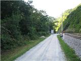
From Ljubljana we drive towards Litija and continue to Zidani Most. If coming from Styria, we also drive from Celje via Laško to Zidani Most. We park at the railway station, or we can park on the gravel road 1km before Zidani Most (from the direction of Litija), where the main road crosses the railway line.
Route description:
WARNING: This old version of the path through Škratova dolina is officially abandoned and closed. Passage along this route is no longer possible, as its middle and upper sections run across private land and right by house thresholds where owners prohibit passage, and in the area (especially in the settlement Ključevica) aggressive dogs are often let loose. Since the section is not maintained, the markings are incomplete and the path is overgrown with thorns and nettles. For the ascent from Zidani Most, be sure to choose the officially maintained New path through Škratova dolina, which the Mountaineering Club Kum Trbovlje has newly marked so that it turns right and completely avoids the disputed homesteads.
If we started the path at the railway station in Zidani Most, we go about 1 km along the road towards Hrastnik. Where the road crosses the railway line, there is a hand-operated swing "cicka", with the help of which we cross to the other side of the Sava. Riding the cicka is a special experience. Once on the other bank of the Sava, we continue straight up the hill, ascending along the stream. The path, which crosses the stream several times, leads us to abandoned mills.
At the top of the ascent the path levels out and Škratova dolina begins. The path through Škratova dolina partly follows a cart track. At the end of the cart track we cross a meadow next to which there is an older farm. Soon we reach an asphalt road, where we continue right towards Kum. On the left the path from Radeče joins us. The road ascends and takes us past houses in the settlement. At the last house we go under a shelter, where the path continues into the forest. After a few minutes of ascent we emerge from the forest and can already see the summit. The path takes us past houses and later turns back into the forest. At the chapel in the forest we continue straight along the path; from the right the marked path from Mali Kum also joins. Another ascent of about 15 min awaits us, and we are already at the summit of Kum.

Photos:
 1
1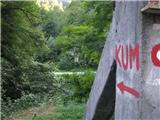 2
2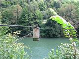 3
3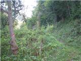 4
4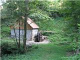 5
5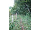 6
6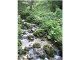 7
7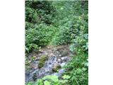 8
8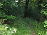 9
9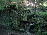 10
10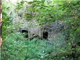 11
11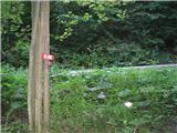 12
12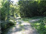 13
13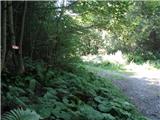 14
14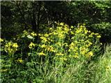 15
15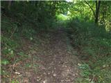 16
16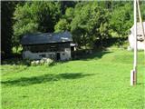 17
17 18
18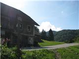 19
19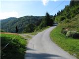 20
20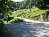 21
21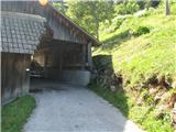 22
22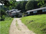 23
23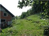 24
24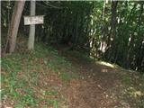 25
25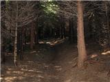 26
26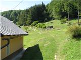 27
27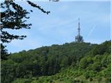 28
28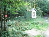 29
29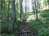 30
30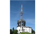 31
31 32
32
Discussion about the trip Zidani Most - Kum (through Škratova dolina (old path))
Show older messages
|
| petruša16. 04. 2010 |
Has anyone hiked to Kum through Škrat's land? I'm curious about this ride across the Sava with Cicka, what it looks like and how many can ride at once. Whoever has ridden it, please describe it in more detail. Thanks in advance. lp   
|
|
|
|
| Enka16. 04. 2010 |
Here Petruš, this interests me too. And also, can you reach this starting point, where you arrive from Zidani Most with cicka, also by car (through Radeče and on this side past the old bridge)?
|
|
|
|
| ben16. 04. 2010 |
Well, I rode this Cicka about two years ago. Very well thought-out thing and quite simple too. It's good if there are at least two, then with a little help it goes across almost by itself. This cableway is really quite an interesting thing and worth trying. I know you can get to the other side by car too, but as far as I saw, that road is quite narrow and really more suitable for cyclists. But where the turn-off to it is, I wouldn't know.
Lp B
|
|
|
|
| Gorazd G16. 04. 2010 |
The asphalted road on the Kranj side of the Sava branches off the main roads in Hrastnik or Radeče. From Radeče through the settlement and past the old bridge is closer than from Hrastnik, but therefore (at least from the old bridge onwards) no less narrow.
Really ideal for a bike (we kids rode it many times), but only until you spot an oncoming car. Meeting is very tricky in many places.
Cicka. I rode it already in elementary school years after descending from Kum and remember that day very well. Since I was alone and not yet very strong, a friendly woman from the nearby farm helped me.
|
|
|
|
| Hybrid16. 04. 2010 |
I rode it about a month ago and continued the path through Škratovo dolina, so I have fresher memories...
In short, it's worth trying this thing. Seriously!
When you get to it or to the boarding point, you pull the basket to yourself with the pulley. Then you sit in it, close the door and let go. Cicka then gains such speed that you almost reach the other side. Maybe you have to pull the last 10 or 15 meters, but it's not hard. It's certainly easier if you're two, because then the other pulls you to the end with the help of that pulley. I was alone and had no problems. I think it's not too hard for an adult, just a bit awkward to pull because you have to use the rope that's tensioned on the side of the basket. But there is indeed a farm nearby where an older gentleman lives who will gladly help you. He offered me help himself when I passed the house. Well, then I didn't need help. Maybe you have to pull the last 10 or 15 meters, but it's not hard. It's certainly easier if you're two, because then the other pulls you to the end with the help of that pulley. I was alone and had no problems. I think it's not too hard for an adult, just a bit awkward to pull because you have to use the rope that's tensioned on the side of the basket. But there is indeed a farm nearby where an older gentleman lives who will gladly help you. He offered me help himself when I passed the house. Well, then I didn't need help.
As for how many can ride at once... it says capacity 160kg. And there's not much space either. Two adults probably can't squeeze in easily. One adult and one child yes.
Hope I answered you.
LP
|
|
|
|
| petruša17. 04. 2010 |
Thank you very much. I think we'll go try it, as it will be an experience for us adults and for the kids 10 and 11 years old. Thank you very much. I'm just a bit in doubt that we might get stuck in the middle, but since you say it goes, we'll have to try. lp
|
|
|
|
| petruša17. 04. 2010 |
Thank you very much. I think we'll go try it, because it will be an experience for us adults and for the children aged 10 and 11. Thank you very much. I'm just a bit in a dilemma that we might get stuck in the middle, but if you say it goes then we have to go. lp
|
|
|
|
| Enka17. 04. 2010 |
Thank you very much everyone for the information. Maybe we'll really dare the cicka. The road is obviously not the best choice :-).
|
|
|
|
| ben17. 04. 2010 |
Petruša, if you manage to stop in the middle, you'll probably be the only one to succeed And also, two adult persons managed to get through without problems (just that neither has more than 100 kg  ) )
LP B
|
|
|
|
| petruša25. 04. 2010 |
Yesterday we went to Kum with the family. The kids really enjoyed riding the cicka across the Sava. At first they were hesitant and didn't want to, but once they rode it, they would have just ridden across the Sava all day. A really nice experience for the kids, as well as for the parents. The whole path to Kum is also nice.
|
|
|
|
| nejka4029. 08. 2010 |
nice, interesting path, especially the experience of riding the "cicko" across Sava.. highly recommend.
|
|
|
|
| Matjaz_6529. 05. 2011 |
for a pleasant circular tour it's worth combining the ascent through Škratova dolina with the return through Čebulno
for the connection between Trbovlje and Zidani Most the train is ideal ... although I used a bike myself ... with which I took about 40 min from Trbovlje to Zidani Most.
a few more photos
|
|
|
|
| bojkoker30. 05. 2011 |
For everyone still interested in the path to Kum via Škratova dolina:
I went up there again today.
From Zidani Most (from the "wire" across Sava) we start up the gully. The path is very steep right from the start and leads us here and there along the markers (on the whole path I spotted only one sign with time to Kum. We constantly walk close to the water and have a nice view of the small waterfalls below us. At the former old mill we are (I'll write my times and if you have good fitness they apply to you too, otherwise add "something" - say 30%) in good 20 minutes. Here we cross the stream for the third time and in a couple of minutes we are at the former Koritnik homestead, which is now completely overgrown with greenery and looks quite dark. So we hurry, skillfully avoid the mud on the path for about 150 meters and we are on the gravel road in a little over half an hour. We go straight, don't turn anywhere and in the next good 10 minutes, when we previously passed the gravel road turning right uphill, but we still go straight, we are at the next abandoned "ruin" in the greenery. If we're not careful enough, we can easily miss it. Immediately about 100m behind it, the road turns right uphill again, but we keep going straight, now on a path eroded by raging waters when it rains heavily. So always just straight. Even when two paths split, one slightly left, the other slightly right, it doesn't matter which one we take. I prefer the right one, the left is very overgrown and eroded by water, although the right is partially eroded too. We are in a wonderful forest where there are hundreds of thousands of bellflowers in spring and soon it starts to lighten at the end of the forest. That means we are close to the exit to the meadow (look ahead and up and you will spot a piece of the tower on Kum and the tower church which is a good half hour before the tower) and after a couple of 100 meters walking on the grassy path, we pass the homestead where a solitary man lives. To here I walked exactly 1 hour, normally I'd say you'll be there in an hour and a half, maybe even a bit later. Another good 5 minutes and the path exits onto the asphalt road and we are already "at Rezka" on Čimerno. Usually the hostess is home, always friendly and often the traveler is lucky to be served a shot of homemade. Healing. Tasty, believe me. I even drank it myself although I don't drink alcohol otherwise. From Rezka you can see part of the tower on Kum again, if you look well. Now we are roughly halfway, maybe a bit more. We head uphill on the asphalt road, in the bend we turn sharply right and continue past the houses. Soon the path turns left from the road into the forest. We follow the markers and after about 20 minutes we reach the gravel road again. After the chapel, we soon turn right and after 5 minutes we reach the "top" of the hill, from where we spot Kum. I was here in an hour and a half, a minute or two more.
The path then turns downhill but not for long. When we pass a few houses and "around the bend", we go STRAIGHT. Today I went this far for the first time but missed the path and went down the road about 500m and then on some indicated path, eroded and covered with branches, left uphill. I pushed up for about 10 minutes and then turned back. I thought I would cross towards the tower which I saw for a moment earlier straight through the forest but I changed my mind. I think I wasted about twenty minutes on foolishness. So I returned to the right path from the junction which I missed due to carelessness, about good 10 min (say on average rather good 15) to the hut on Kum. The last part of the path is incredibly steep.
The whole path mostly leads through the forest, in the shade, down by the water, where wonderful photos can be taken. I took 2 hours and less than 15 min for the whole path, say 2 hours, if I hadn't strayed, maybe a bit less. How much is realistic to Kum from Zidani Most, I have no idea. As I said, I didn't spot any marker with time below. Say that I was fast and that it's "normal walking just under 3 hours?
Later I'll add a few more photos
|
|
|
|
| bperc9. 07. 2011 |
Today I visited Kum for the first time via Škratova dolina and was very disappointed with the unkempt trail and the trail is also very poorly marked. Maybe the marks aren't visible because it's so overgrown, so it needs to be cleared. So, the PD that maintains the mentioned trail, I think it's high time to grab the "machete" and tidy up the trail.
|
|
|
|
| jurep28. 11. 2011 |
So, yesterday I visited Kum for the first time from Zidani Most. I can say that the path is well marked, not too overgrown and I think no one will have major problems finding the trail markers.
The ride with "CICKO" was really special and I must say a pleasant experience, which I warmly recommend to everyone. The initial ascent is really strenuous, but the waterfalls and the beauty of nature on offer are something special. I must also mention Rezka at Čimerno, who kindly offered us homemade brandy, which with the strong and cold wind that was blowing really came just right.
On the summit still some sunshine and my expectations that I had before departure were fulfilled. Warmly recommend...
|
|
|
|
| lakkon8. 09. 2012 |
Is this 'Cicka' in OK condition? I wouldn't want to be negatively surprised after a one-hour drive to the starting point. On Tuesday or Wednesday we're going from Zidani Most to Kum with clear nice weather forecast.
|
|
|
|
| Gora Trma8. 09. 2012 |
The Cicka is used by local residents and there shouldn't be a problem. Nearby there is a bistro at Ancki's (something like that and it's on the left bank).
|
|
|
|
| rinoz8. 09. 2012 |
Regarding the length of the path to Kum from Zidani Most: on the wall behind the train station there is a mountaineering sign indicating 4 hours (I'd attach a picture but I don't know how). I walked this path in family pace in three hours, including a picnic break along the way. The path is pleasant, only annoying at the beginning because it's overgrown.
|
|
|
|
| Gora Trma8. 09. 2012 |
For information about the Cicka, the previously mentioned one was the Hren family bistro in Suhadol.
|
|
|
|
| klemen12516. 03. 2013 |
Nice greetings to all
Today my colleague and I walked this path. Path start is muddy, partly frozen higher up 25cm snow. Tour is well trodden. Cicka works perfectly and is in good condition. We needed 5h for the path, tour is 16km long.
Happy trails!
|
|
|
|
| ajax16. 03. 2013 |
Ah, nice that the Cicka is still alive, usually we go straight from Radeče.
|
|
|
|
| jprim14. 05. 2013 |
This Cicka, as we call it, is really an interesting thing, but I couldn't get into it, so we parked under it, of course on the other side of Sava, where you drive from Radeče.
Path interesting, solitary, in one part veeeeery muddy, as the path is worked by forest logging, on Sunday you sank into the mud up to your ankles.
Probably different when the path dries, as it rained the day before.
And some brushwood has accumulated.
LP!
|
|
|
|
| lakkon20. 05. 2013 |
On the map I see a hiking path to Kum from the north side from Sava or Podkraj. But I haven’t found descriptions for this path, at least starting from those places.
I have a feeling it’s the shortest path starting right by the Sava or on the same side of the Sava as Kum. Probably also the steepest, which is actually OK for me.
I’d like to go to Kum during the week, but 3-hour hikes before or after work don’t suit me best.
So I’m interested:
- can you park a car in Podkraj or Sava for this hike?
- with average fast walking, how much time does the Sava(Podkraj)-Kum path take (compared to this path: http://www.hribi.net/izlet/zidani_most_kum_cez_skratovo_dolino/25/192/2247)?
|
|
|
|
| josst20. 05. 2013 |
lakkon: it’s the path from Hrastnik:
http://pd-kum.si/pot-iz-hrastnika/
At the start there’s quite a steep ascent to the village Župa, then it’s not so bad if you’re reasonably fast you’ll be up in two hours, I usually take around an hour and a half.
You can park the car in Podkraj, actually right at the start, as the path goes straight into the forest.
|
|
|
|
| lakkon21. 05. 2013 |
josst,
thanks. I'll go tomorrow (Wednesday), if the weather forecast is OK. start approx 15:45.
|
|
|
|
| Janiel7423. 05. 2013 |
Yesterday afternoon to Kum from Hrastnik or. Podkraj. I don't get why this path isn't listed here on hribi.net ...Super path, very varied and doesn't drag Ideal weather!
|
|
|
|
| nincokl1. 07. 2013 |
Yesterday on Sunday 30.6.2013 I visited Kum for the first time via this mentioned path, let me note that the path is catastrophically poorly marked, at the key junction you don't know at all whether left or right, of course I got lost and spent one hour to find the right path, some local told me that someone probably maliciously removed the marks at the key point, otherwise an interesting path!!
|
|
|
|
| lakkon2. 07. 2013 |
nincokl,
yes, this can happen on hikes. I have experiences from elsewhere. Then your conquest of the 'Posavje-Zasavje Triglav' took quite long in the end considering that 3h is stated for this path. As if going to a decent 2000er. I rather went up from the Hrastnik side, from Podkraj, for which I got info from a couple of posts above. With taking photos not too fast in two hours up. And that's 1km ascent. super. There wasn't any more time available that nice afternoon.
|
|
|
|
| nincokl2. 07. 2013 |
lakkon I agree with you that the other access is nicer, but I wished for this path and of course was disappointed, but hiking in mountains is like that, sometimes you like it sometimes not. No I would criticize this path once more only because of poor marking, because those who visit Kum for the first time on this path can easily get lost, therefore I would appeal to the competent mountaineering association to add some signs or marks at key points on this beautiful path!!
|
|
|
|
| mrzlica2. 07. 2013 |
I was on Saturday 29.6 for the first time on this path, and there was no problem regarding markings.....so, I don't know where you were looking
|
|
|
|
| sirt119. 09. 2013 |
Hello
a few days ago I was on Kum, not via this path but from Hrastnik, return via Čebulova to Trbovlje. Very pleasant tour.
I'm writing because we all forget the train too much. Starting points are Ž.P. Zagorje, Trbovlje, Hrastnik, Zidani most, Radeče. So no problems returning to the start. You can calculate yourselves how many different path combinations there are. Many children haven't ridden the train yet. What an experience: first the train then the Cicka!
|
|
|
|
| bruny20. 09. 2013 |
About tours in combination with train... I've been writing personally since spring on the conditions forum Zasavsko - Posavsko hribovje and Dolenjska, because that area is ideal for visiting by train... but it's true that for most Slovenes the car means a lot and if you're already paying credit or leasing installments you'll drive too... and one more thing, if you go on a tour alone or maybe two the train still pays off, with three, four, five the math no longer works and for family it's unfortunately better to go say with an MPV or share costs with more people in the car... Unfortunately that's how it is, although with train it's quite pleasant and also very easy precisely because of connecting different starting points and endings of activities. Thirty, forty, fifty years ago trains were practically bursting at the seams on weekends, full of hikers and walking enthusiasts... Maybe we posted in the wrong place... Best regards
|
|
|
|
| sirt121. 09. 2013 |
bruny
thanks for the information. I don't know if the place is wrong.
If a highlander is conquering Dolenjska, the train is a very good solution.
As for the prices, there are pensioners', family and group discounts as well as discounts on public holidays, so everyone can find something for themselves. LP
|
|
|
|
| VanSims23. 09. 2013 |
The previous evening's excursion in the Carnic Alps wasn't enough for this weekend, so yesterday I also visited Kum from Zidani Most.
So:
1. Cicka works fine. Even if you're alone and reasonably fit, it goes. You have to hold it so it doesn't get away (like any woman ), meanwhile load the backpack, quickly jump in and quickly close the door. At the end, you have to pull yourself out using the strap on the right side, and at the exit repeat the procedure: again hold the strap, first out with the backpack, jump out, hold it to close the door and let it go its way
2. The trail itself is really poorly marked. Unfortunately, I didn't have this description printed. And even the description itself wouldn't have helped much, except for the comment by user 'bojkoter', who described it best at least to the exit at Rezki (I assume that's the farm on the left at the signs when we come from the meadow to the asphalt). From there it's a bit easier, but to there, don't go right at that cross... unless you want to meet a somewhat strange person and waste another 45 minutes!
That sign at the station in Zidani Most showing 4h probably includes all the getting lost and searching. In that case, it's a realistic time, otherwise with breaks say a good three hours.
The descent to Hrastnik is another story. Marking-wise it's problematic especially the course of the trail through the village Župa and even before there are some issues. After that village, just a steep descent to the train station (and for me still a beer in the nearby fishing club ). The time of two hours on the sign at the top again holds, taking into account all the gettings lost, otherwise a good hour and a half.
|
|
|
|
| bruny23. 09. 2013 |
In mid-August from Hrastnik to Kum. Uphill it was marked solidly, perhaps through the Župa settlement really somewhat less visible... Otherwise, it's a path with life, maybe I'm repeating myself a bit... just right worn, so you can follow the trail and there's practically no erosion. There are many approach variants to Kum and the paths suffer somewhat evenly as seen. Even more interesting to me was the path to Zagorje after the junction with the Trbovlje one in Čebulova dolina. Somewhat less known, I descended it and the final part along the torrent to the remains of the Poitorek sawmill is really good. It's a bit distant from Zagorje, the gas station below Zagorje towards Trbovlje is more suitable as a starting point if someone decides to ascend...
|
|
|
|
| jernej.spiler10. 01. 2014 |
hi,
I'm interested in what the path from Kum to Zidani Most is like, is it passable through the forest along the stream?
Thanks
LP
|
|
|
|
| starakapa10. 01. 2014 |
Last week I was around there and I can tell you that the path is dry and without problems. It's also nicely marked.
|
|
|
|
| navdušena20. 11. 2014 |
Oj!
Has anyone gone from Zidani Most to Kum recently? How is "Cicka"? Is it still safe and functional?
What about the intermediate detour to Nebeška gora? Is it marked, do we know where to go?
|
|
|
|
| Gorazd G20. 11. 2014 |
Cicko was replaced with a new one about a month ago. It works nicely.
The path to Nebeška gora is marked from the east and west sides. If you come from Zidani Most, the path from the west side is more suitable. Visiting Nebeška gora extends the tour to Kum by a good hour.
|
|
|
|
| navdušena20. 11. 2014 |
GorazdG, thanks for the info. I think Kum will "fall" already on Saturday!
|
|
|
|
| navdušena22. 11. 2014 |
Today from Zidani Most first with "Cicko" across Sava - no problem, inside possible or a bit tight if with backpacks, two people sit. Really cool.
Then to the top of Nebeška gora. Around 2h 30 or so. Junction marked when you reach path crossroads. From Nebeška gora another approx. 1 hour 15 to Kum. All very well marked. Descended to Hrastnik. Slovenske železnice: 20 min delay. So what! It was nice and recommend.
|
|
|
|
| Merymery1. 01. 2015 |
hello, did anyone go with cicko across Sava then along Škratova dolina to Kum a couple of days ago, can you drive across Sava and what's the path to Kum summit like
best regards mery
|
|
|
|
| PohodniskoSrce4. 12. 2015 |
Hello! Today we headed to Kum via Škratova path. The path is very interesting! The "cicka" is modern, it's interesting to cross the Sava with it ! It's good to be at least two because if you go alone with "cicka" there are small chances you'll get to the other side without someone pushing you! All paths are well marked without any risk. With "cicka" max two people plus backpacks. The path is wonderful and not so innocent ! Best regards and safe steps! HikingHeart. On my profile there are some photos for information.
|
|
|
|
| tvodop3. 05. 2016 |
A few days ago we failed to reach Kum via Škratova dolina. On the left bank of Sava (Zidani most) it said the ferry was out of service. It was moored on the other side of Sava. No announcement about this from PZ and PD Trbovlje.
|
|
|
|
| jprim3. 05. 2016 |
You could drive to the other side by car. We did that some time ago too. Well, unless you wanted to go by ferry. I had a phobia, so that ride was cancelled then.
Best regards!
|
|
|
|
| garmont3. 05. 2016 |
The problem is if you arrive in Zidani Most by train...
|
|
|
|
| hribuc854. 05. 2016 |
Alternative, somewhat less safe option is the following. From ŽP Zidani Most walk across the road bridge over Savinja towards Radeče and then along the main road 2 km in the direction of Radeče to the iron bridge over Sava from the Austro-Hungarian monarchy era. Here cross Sava and return on the "Kranjska" side to the gondola over Sava. The return is safer, it runs along a less busy road right above Sava. In short, this detour lengthens the path by approx. less than an hour or a good 3/4 hour if done more seriously. Warning once again. The direction to the bridge before Radeče is dangerous mainly due to trucks, so extra caution is not superfluous. But this railway bridge is the closest to ŽP Zidani Most. That's all from my side. Hope they repair the gondola soon.
Good luck!
|
|
|
|
| luigi4. 05. 2016 |
The ferry is repaired, so off to Kum happily
|
|
|
|
| garmont31. 08. 2016 |
The storm on 29.8.2016 washed away the concrete platform with railing that you step on to climb onto Cicko.
|
|
|
|
| Brave6619. 11. 2016 |
Is the footbridge in use?
|
|
|
|
| docepe219. 11. 2016 |
The footbridge is normally in use, the platform is also in its place, and now they've piled up the slope anyway.
|
|
|
|
| Brave6619. 11. 2016 |
Great, then tomorrow cheerfully to Kum
|
|
|
|
| Brave6619. 11. 2016 |
Is there a lot of snow up there?
|
|
|
|
| tvodop19. 11. 2016 |
almost no snow. thaw already on Thursday
|
|
|
|
| Brave6619. 11. 2016 |
darn, I was looking forward to it being white....
|
|
|
|
| kahu23. 06. 2017 |
Hi! Does Cicka work? LP!
|
|
|
|
| Janezs23. 06. 2017 |
A week ago we walked the Posavski krog. The path through Škratova dolina is very overgrown in the lower part, nettles, thistles, tall grasses. 
|
|
|
|
| Lord Pes13. 09. 2019 |
Hi!
I'm wondering, what's the path to Kum through "Škratovo dolina" like?
Best regards from Brežice
|
|
|
|
| cokla15. 01. 2020 |
Cicka is unusable again, as it was damaged in an accident at the level crossing with the railway.
|
|
|
|
| jprim17. 01. 2020 |
Well, interesting, about two months ago we were still using it.
Quite an adrenaline rush, especially when you arrive on the other side and two dogs attack you.
On the return trip they also rushed at us properly.
Cheers!
|
|
|
|
| karibu17. 01. 2020 |
I've been with Cicka several times already and never had any issues with dogs.
|
|
|
|
| jprim17. 01. 2020 |
Or are there two Cickas? The house on the other side of the Sava has two dogs and when they hear Cicka rattling against the iron they start barking. A few meters from the landing along the path and you're already threatened by dogs' teeth.
Cheers!
|
|
|
|
| karibu17. 01. 2020 |
What more can I tell you? Obviously they "smell" you
Best regards and good luck!
|
|
|
|
| jprim18. 01. 2020 |
Karibu
Anyway maybe the dogs were locked in the house.
Maybe they will chase you sometime too?
|
|
|
|
| jprim18. 01. 2020 |
Karibu sorry, the computer just records something on its own
I meant they sniffed you out in a homely way.
Regards!
|
|
|
|
| jaz19. 01. 2020 |
On 2 January this year very friendly, happily wagging her tail and even went part of the path with me. Last year no problems with them either. Obviously they know who is not the right one and bark at such a person. Regards!
|
|
|
|
| jprim19. 01. 2020 |
Maybe so, we are not the right ones ...
Next time I'll take sausage with me
Regards!
|
|
|
|
| azzey8. 05. 2020 |
Hi, is Cicka working already?
|
|
|
|
| zmp28. 05. 2020 |
It works, at least last weekend it did.
|
|
|
|
| navdušena11. 01. 2022 08:54:32 |
Is "cicka" okay now? Is it working?
|
|
|
|
| Avje29. 01. 2022 02:53:35 |
Today I rode with cicko. It works.
|
|
|
|
| Zanverbic29. 01. 2022 10:20:02 |
Just crossed the Sava river with cicko. It works
|
|
|
|
| davou11. 01. 2023 07:28:32 |
I do not recommend the trail. On Sunday 8.1.22 we set off along the mentioned trail. Already before crossing the green passage, a dog attacked us, which came from behind the fenced workshop. Under the summit, the trail passes several homes, under the shelter and literally over the thresholds of houses. In the settlement Kljucevica, another dog attacked us and it was pure luck that the owner somehow but successfully put the raging dog in the kennel. When we were returning, the dog was released again we went higher to the neighbors and asked them to call the owner to lock the dog in the kennel. I recommend some other trail
|
|
|
|
| padez13. 01. 2023 10:15:06 |
Mountaineering Association Kum Trbovlje, the trail maintainer, what do you say to the previous comment???
|
|
|
|
| docepe213. 01. 2023 11:35:43 |
If anyone had looked at the trail descriptions, they would see that the MA has already taken action and changed the course of the trail so that it turns right before the houses.
This description is even on this page under the label new trail. And on the map on this page, only the new marked trail is drawn.
|
|
|
|
| padez13. 01. 2023 21:00:21 |
So @davou and the team did not walk the newly described (and hopefully marked) trail.
Let's leave that now. What about the "cicka" - is it really not operating, as stated in the note?
|
|
|
|
| docepe214. 01. 2023 06:37:33 |
The problem is that on the old section there are still paths and markings are partially visible. Cicka is operating according to the latest information. Last year it was a target of vandals and they fixed it up quite a bit.
|
|
|
|
| padez14. 01. 2023 10:14:11 |
It would be good to cancel that notice on mapzs from 24.06.2021 that the cable car is not operating until further notice and consequently access from Zidani Most is not possible...
|
|
|
|
| robibre15. 01. 2023 17:07:36 |
The path is newly nicely marked and the cable car is operating normally.
|
|
|
|
| davou18. 01. 2023 06:55:11 |
Then delete that "option" and the markings on the old path. Also the option for excursion from Zidani Most appears first!
|
|
|
|
| marepn9551. 03. 2023 10:25:58 |
Is there perhaps a mobile number where I can check if Cicka is operating? Or does anyone have information if it's currently running? Thanks and best regards
|
|
|
|
| mlostr2. 05. 2023 10:28:19 |
And what is the chance of getting across if you go alone?
|
|
|
|
| mado2. 05. 2023 15:37:13 |
Cicka is operating i.e. it was working properly 18.3.2023 when I was on it.
If you go alone it is harder because you have to pull yourself alone along the cable which is next to Cicka. We didn't try how hard that is.
|
|
|
To post a comment you must log in:
If you do not yet have a username, you must first
register.