Country: Austria
| Latitude/Longitude: | 46,8389201°N 14,693055°E |
| |
Altitude: 1551 m
Type: Mountain hut
Weather forecast:
Description:
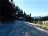
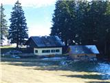
Zechhütte is a mountain hut at an altitude of 1551 meters in the Lavanttal Alps. The mountain hut is located 4 km east-southeast of peak Ladinger Spitz. The nearest peak is Moarhaltberg, which is located 0.5km severo-severozahodno. The mountain hut is located east of the valley Görtschitztal.
Images:
Points in the vicinity: