Hike.uno
Hike.uno
Login
Login
Username:
Password:
Login
Not registered yet? Registration.
Forgot password?
Großer Sauofen

Großer Sauofen

Country: Austria
Latitude/Longitude: 46,8240547°N 14,6492114°E
Altitude: 1895 m
Type: Summit
Weather forecast:
Su
Mo
Tu
We
Th
Description:
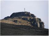
Großer Sauofen is 1895 meter high peak in the Lavanttal Alps. The peak is located in country Austria 3 km south of peak Ladinger Spitz. The nearest mountain hut is Wolfsberger Hütte, located 1.4km northeast. Even closer is Thersaler-Zeche, which is located 1.3km to the west. The peak is located east of the valley Görtschitztal.
Images:
Großer Sauofen Großer Sauofen
Show map
Points in the vicinity:
Detailed descriptions
Webcams
Weißbergerhütte (Weißberger Alm)
5,7 km north-northwesterly
Gemeinde Diex in Kärnten
8,4 km south-southwesterly
Gemeinde Diex in Kärnten
10,5 km south-southwesterly
Klippitztörl Straße
13,8 km north-northeasterly
Starting points
Ladinger Straße
5,1 km east-northeasterly
Klippitztörl
12,6 km northerly
Seetalerhütte (Klippitztörl)
13,6 km north-northeasterly
Schwarzkogelhütte
14,0 km north-northeasterly
         
Copyright © 2026 Hike.uno, Terms of use, Privacy and cookies